As I began to write this on June 6 at 5:00pm, the TTC had not yet published the detailed memo of service changes for June 7. There is a web page listing World Cup related service changes, but no details about service frequencies. On an interim basis, I have used the electronic version of the June 7 schedules (GTFS data) as a source for info on scheduled service. On game days, there will be additional service as needed.
Updated: The TTC issued the detailed service memo in the early hours of June 7. Thanks to those burning the midnight oil to get this out. This article has been updated to consolidate info from the memo. Note that June service changes for subway, LRT and bus routes will not occur until June 21, and these will be covered in a separate post.
307 and 311 Bathurst night services: Stopping arrangements at Bathurst and St. Clair West Stations clarified.
Streetcar route maps added at the end of the article.
301L route clarified to include extension to Dufferin Loop.
Streetcar vehicle allocation tables added.
Spreadsheet of detailed changes added. Revised to include 929 Dufferin Express.
List of destination sign changes added.
Bathurst Corridor
Night service on 307 Bathurst bus will be shortened to end at Bathurst Station. Service south to Exhibition will be provided by a 311 Bathurst night car running from St. Clair to Exhibition Loop.
Service on 511 Bathurst will be improved (see table later in this article).
Updates:
307 buses will loop through Bathurst Station, but will lay over and serve a new stop northbound on Bathurst at London (opposite the station).
311 streetcars will run out of service through St. Clair West Station.
Spadina Corridor
Service on the 510 Spadina streetcar will be shortened to turn at Queens Quay Loop. Service to Union Station will be provided by 509/309 Harbourfront and by 310 Spadina. (Corrected)
Waterfront
Service on 509 Harbourfront will be improved (see table later in this article), and a new 309 Harbourfront night car will operate.
Dufferin Corridor
Service on 929 Dufferin express will be added on Sunday evenings on Game Days running every 8 minutes.
King Corridor
Service will be improved on 504 King. On Game Days, the 504B from Broadview Station will turn back via a loop of King, Queen and Shaw without serving Dufferin Loop. See detailed map and schedule in the schedule section later in this article.
Queen / Lake Shore Boulevard West
507/501/301 Long Branch service will be replaced by buses due to construction at Long Branch Loop.
Two branches of the replacement bus service will operate:
507 from Humber Loop to Long Branch Loop via Park Lawn.
507M from Humber Loop to the Humber Bay Shores area looping via Marine Parade Drive.
This configuration will run until Labour Day weekend. In September, 507 streetcars will return as far as Kipling Loop, and the 110 Islington South will be extended west to Long Branch Loop.
508 Lake Shore streetcar service will be suspended for the summer season returning after Labour Day.
Updated: 301L night buses will operate from Long Branch Loop to Dufferin Loop via Queen and Dufferin providing an overlap with the 301 Queen night car.
See map in the schedule details later in this post.
This article updates previously published on the Dufferin bus and Bathurst streetcar routes to show how the travel times in affected areas changed with the gradual implementation of red lanes over past months.
In summary, there is a reduction in travel time during some periods, but not others, typically because congestion is not an issue all of the time. An important factor, one we saw some years back on King Street, is not just to lower travel times, but to reduce the variations that contribute to irregular headways.
With a reserved lane, periods that might not be badly congested all the time have extra protection against surges like special events or construction projects that remove some network capacity. This depends on enforcement, of course, and paint alone will not keep motorists out of transit lanes.
The balance of the article shows how travel times have evolved from 2024 to May 2026 as a reference point before the World Cup events stress the transit and road system.
Also shown here are the headways on the three services from terminals and along the route. This is a very serious problem, and, indeed, the Achilles’ Heel of the RapidTO scheme. It is not enough to reduce travel times by a few minutes if the service reliability is poor.
Riders are more sensitive to wait times than travel times, especially over shorter distances because the unreliability of a wait contributes substantially to total travel time. On a route like Dufferin with local and express service, the short travel time can be completely outweighed by the longer wait for a bus which is also likely to be crowded when it eventually arrives.
This is an update from previous articles about the 511 Bathurst Streetcar showing the effect of operational changes in recent months. These include:
A shift from 10-minute to 6-minute headways for daytime service effective mid-November 2025.
Implementation of red transit-only lanes on Bathurst south from Dundas in Fall 2025.
Increased headway supervision to reduce bunching and gaps.
These effects took place concurrently, and it is difficult to tease apart the individual effects especially as seen by riders. For example, bunching produces wide gaps in service, but these can be reduced both by better headway regulation and by more frequent scheduled service. Reserved lanes can reduce fluctuations in travel times leading to less irregularity in headways. Some of these effects were seen years ago with the implementation of the King Street transit corridor. This is not a transit epiphany, but rather a rediscovery of what is needed to ensure reliable service.
The first part of this article reviews travel times over various parts of the route from January 2024 to February 2026. Between November 2024 and June 2025, the south end of the streetcar route was diverted for construction. Data for this period is included in the charts only for locations north of King which had streetcar service through the entire 2+ year period.
The second part of the article reviews headways (the interval between cars) at key locations. There is a consistent degradation in headway reliability between the southern terminal at Exhibition and Richmond Street northbound, and this exists even after reserved lanes were in place over the entire distance.
The time saving of transit priority schemes can be undone by unevenly spaced service and the extra wait times this causes. Moreover, because a “gap car” typically has heavier than average loads, more riders experience waits and crowding than would be shown in average counts that the TTC typically publishes.
Another important point is that delays and irregularity are not just a peak period issues, but can affect service at midday and through the evening. (This can also affect weekends, but I have not included them here.) On 511 Bathurst, there is a quite striking “heartbeat” pattern with extended travel times almost always on Friday evenings on the south end of the route due to congestion in the Entertainment District. This substantially disappeared after the implementation of red lanes in the area.
Buckets of red paint alone will not solve reliability issues without a culture of regularly spaced service. Note that this is quite different from “on time performance” where staying “on time” can actually lead to erratic spacing when what is needed is headway regulation. Moreover, TTC standards allow some variation in departures giving a window up to five minutes late while still being “on time”. With cars scheduled every six minutes, bunched service does not ring any alarm bells.
This article is the first in the series of review of routes where transit priority measures have been implemented.
After the red lanes are extended north to Bloor Street, I will publish an update to this article.
Readers with long memories might recall the early days of plans for a new streetcar order including discussions about how large a vehicle should be purchased. A major concern at the time was the possibility that the TTC would change schedules and run less frequent service with the larger cars just as they had when the articulated version of the CLRV (the previous generation of cars) arrived in the late 1980s.
That concern was softened by a TTC claim that service would actually improve. Peak periods would see slightly less frequent service, but a net increase in capacity, while off-peak periods would see little change in frequency effectively doubling the capacity of service. At the time, crowding was a big issue and this persisted right up to the pandemic in 2020, by which time all of the old cars had been retired. The management proposal was approved in July 2013.
As the CLRV/ALRV fleet aged, there were problems with reliability of older cars and the need to operate buses on some lines thanks to a shortage of working vehicles. Some repairs were done at considerable cost, but these were more cosmetic than a true life extension.
Moving forward to 2026, there has been a lot of talk of restoring pre-pandemic service levels. TTC fudges the numbers on this in many cases citing vehicle hours operated, not actual service frequencies which have been degraded by longer travel times.
(For example, if a round trip, including terminal layovers, takes two hours or 120 minutes, then 20 cars will provide a 6-minute service. If the round trip gets longer but no cars are added, the service is less frequent, but the number of vehicle hours stays the same. From a rider’s point of view, service is worse, but from a budget outlook, there is no change. This is at the heart of the discrepancy between TTC service claims and rider experience.)
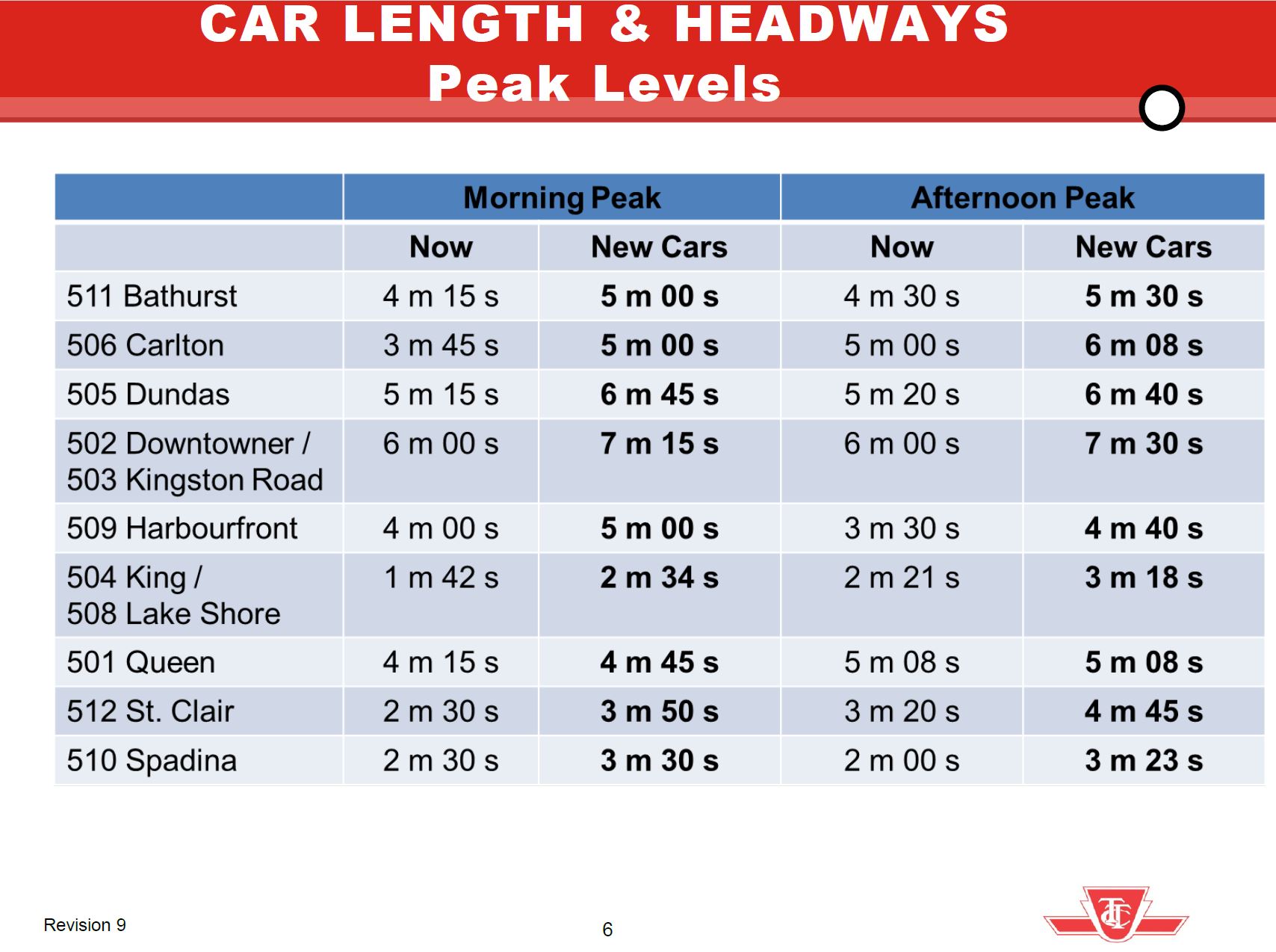
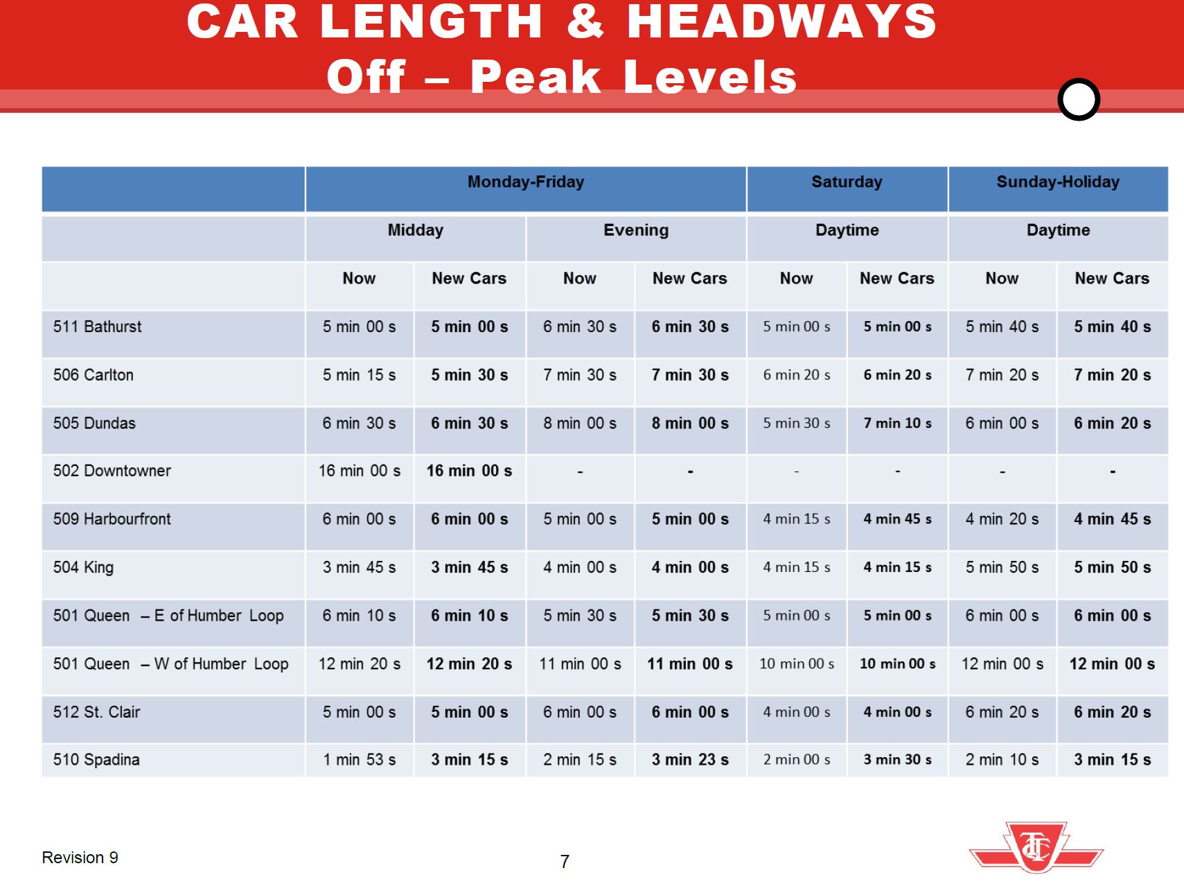
After years of changing service levels and demand, the TTC’s Five Year Plan foresees a return to six minute headways, at most, as a new standard for daytime service. This has been rolled out on some routes over the past year, but not all.
Already at 6 minutes or better: 504 King, 510 Spadina
Improved to 6 minutes: 512 St. Clair (Sept/25), 511 Bathurst (Nov/25), 505 Dundas (Nov/25)
Pending, but with no committed date: 501 Queen, 503 Kingston Road, 506 Carlton, 507 Long Branch.
The Five Year Plan (at p. 4) includes provision for extra spending in 2027 and 2028, but this is not tied to specific routes. There is nothing in the Plan for 2026.
A related issue is the size of the streetcar fleet. Leading up to 2020, the issue was how many cars were actually available, and some service cuts flowed directly from this. With the recent delivery of 60 additional cars, fleet availability should not be an issue although service can still be limited by a lack of operators. The TTC currently schedules 163 cars at peak out of a fleet of 264. If services now operating with buses due to construction were also using streetcars (503 Kingston Road and the Broadview branch of 504 King), the peak requirement would rise to 178. Allowing for maintenance spares this would drive the total requirement to 214 leaving 42 surplus for service improvements (allowing for 8 spares).
February 2026 Schedule PM Peak
Full Streetcar Service
Possible Service
Peak Requirement
163
178
220
Spares at 20%
33
36
44
Total Requirement
196
214
264
Fleet
264
264
264
Surplus
68
50
0
The problem, of course, is that the TTC barely has budget headroom to operate existing services let alone increases.
In theory, some of the surplus cars will eventually operate the Waterfront East LRT extension, but that service is at least 8 years away even assuming Toronto finds the money to build it. In any event this will not require anywhere near all of the current surplus fleet. Another issue is that the “streetcar network” has not operated with 100% streetcar service for a few decades thanks to various construction projects and vehicle shortages.
There are parallel issues with the bus network, but they are complicated by issues of vehicle reliability and the need for a spare pool to cover the unreliable LRT service primarily on Line 6 Finch West. I will turn to the bus fleet in a separate article.
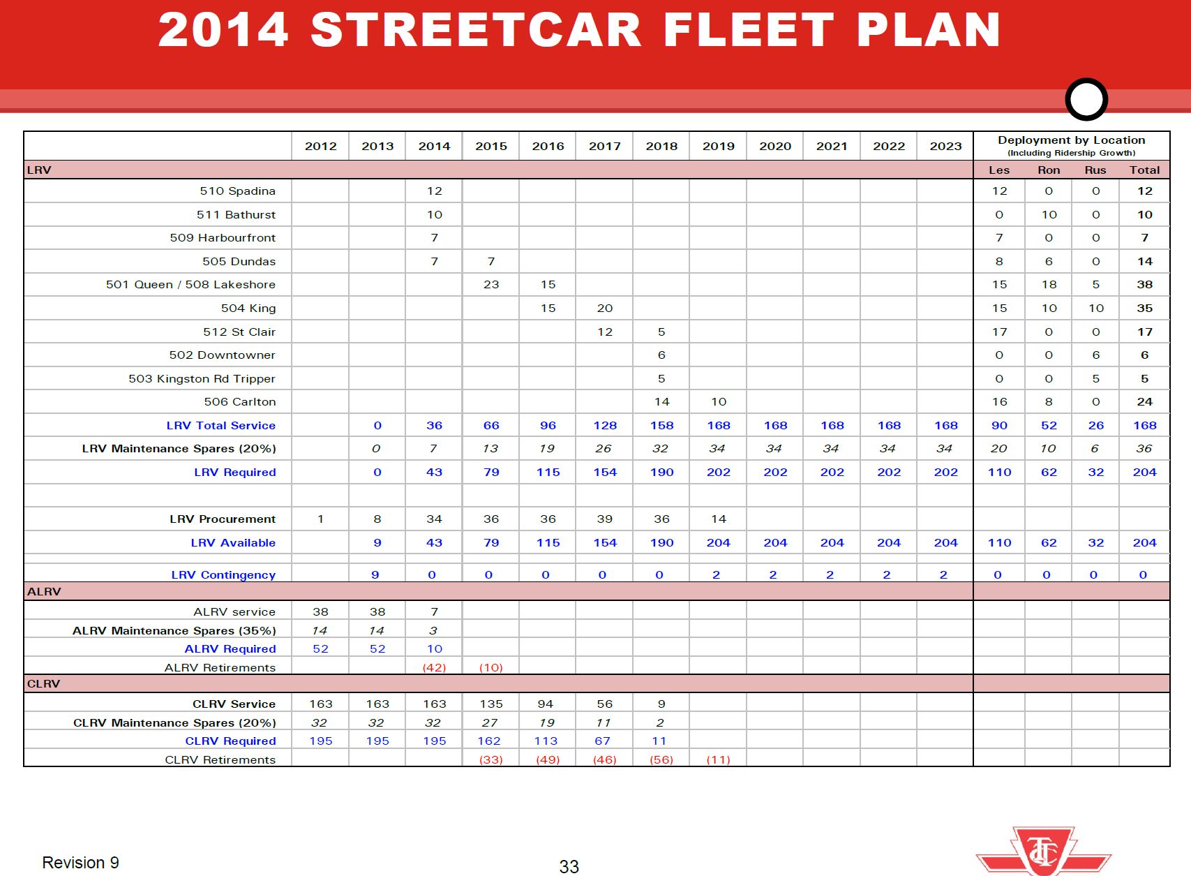
Back in 2013, the TTC proposed how it would operate with the new streetcar fleet. During peak periods, headways would widen particularly where existing service was very frequent. Notably on 501 Queen, there would only be a slight widening of the time between cars in the AM peak and no change in the PM peak. This reflected the fact that Queen was already running with the 75-foot long ALRVs and needed more capacity.
In the off peak, most routes would see no change in service level except for 510 Spadina due to its already frequent service of 50-foot CLRVs that could not be sustained at terminals with the larger new cars.
The overall fleet plan showed a buildup to a peak requirement of 168 cars plus 20% spares.
This plan gave a bright future for streetcar service and capacity growth, but things did not work out that way. Service today is generally lower than originally projected for the new fleet, and part of this reduction is due to slower operating speeds and greater provision for terminal recovery time even on routes with reserved lanes.
A related question is the effect that less frequent service has had on ridership. There is a post-pandemic slump on the streetcar system in part due to work-from-home for office jobs and remote learning for post-secondary students. However, even allowing for the pandemic era drop, the problem remains in attracting riders back to transit when streetcars are less frequent and slower, compounded by chronic problems with service reliability. Charts tracking streetcar ridership from 1976 to 2024, the last year published by TTC, are at the end of the article.
These routes are in the part of Toronto where transit riders should be easy to win, but a long decline in service frequency discourages those who have the option to use another mode including private autos, ride hailing or cycling. Service cuts during economic downturns do not magically get reversed as times improve, and ridership that might be wooed back to transit instead faces less reliable service and a political attitude that favours big spending on subway projects, not surface transit.
The remainder of this article looks at each route in detail to see how the actual service changed from the 2014 plan through the 2020s to today comparing:
The 2014 headways for AM Peak, Midday and PM Peak in the management proposal.
The proposed headways after routes converted to Flexity streetcars.
The actual scheduled service in January 2014, January 2020 (just before the pandemic) and February 2026. Driving times are shown separate from terminal recovery times to illustrate how each component has evolved.
Quite notable on many routes is the growth in both scheduled driving and terminal times. Although it is common in the mid-2020s to regard extended travel times and traffic delays as a recent, post-pandemic phenomenon, this pattern started earlier and is evident in 2014:2020 comparisons. Surplus time, it was argued, would prevent short turns, a claim that is demonstrably false as most riders know on a daily basis, but it slows service, wastes resources and forces wider headways.
This article reviews the change in travel times and speed profiles on 510 Spadina, 511 Bathurst and 512 St. Clair between October 2019 and October 2025 (pre- and post-pandemic). In almost every case, streetcars are slower today than they were six years ago even though two of the three routes have reserved lanes.
511 Bathurst will soon have red lanes from Fleet to Bloor (except for a section north of Dundas), and I will publish updated charts for that route when the lane changes are in place.
By October 2019, streetcar service was almost completely operated with the new Flexity cars, and so the change over time is not explained with a comparison between the sprightlier CLRVs and the newer cars. (For 512 St. Clair, I have also included a comparison with the CLRV era to show the effect of the vehicle change separate from the pre/post pandemic change in traffic conditions.)
TTC is overly fond of laying blame for transit vehicle speeds on “traffic congestion”, but that is too simplistic an analysis especially for routes with reserved lanes. They also have a bad habit of presenting data without the granularity needed to identify patterns and problems by time of day and location. There are many charts in the main part of this article, but they are intended to show each route in detail.
One important point is that it is impossible to know how much change in speed comes from a more cautious operating philosophy as opposed to traffic conditions. There is, of course, the slow operation through junctions, but that does not explain slower travel on straight track with no special work. Traffic signal effects also show up, particularly in time spent holding nearside at intersections and then again at farside stops. Some areas are inherently slower than others such as Spadina from Queen south with many close-spaced intersections and signals that generally favour east-west traffic. The situation is particularly bad between Front and Queens Quay where the primary job of signals is to handle traffic to/from the Gardiner Expressway.
Any move to speed up operations on streetcar routes requires more than quick fixes like stop eliminations, and detailed block-by-block reviews are needed. In some cases there will be trade-offs between transit and other road users. Arguments for better priority will fare better if and when the TTC improves service so that there are actually transit vehicles to prioritize.
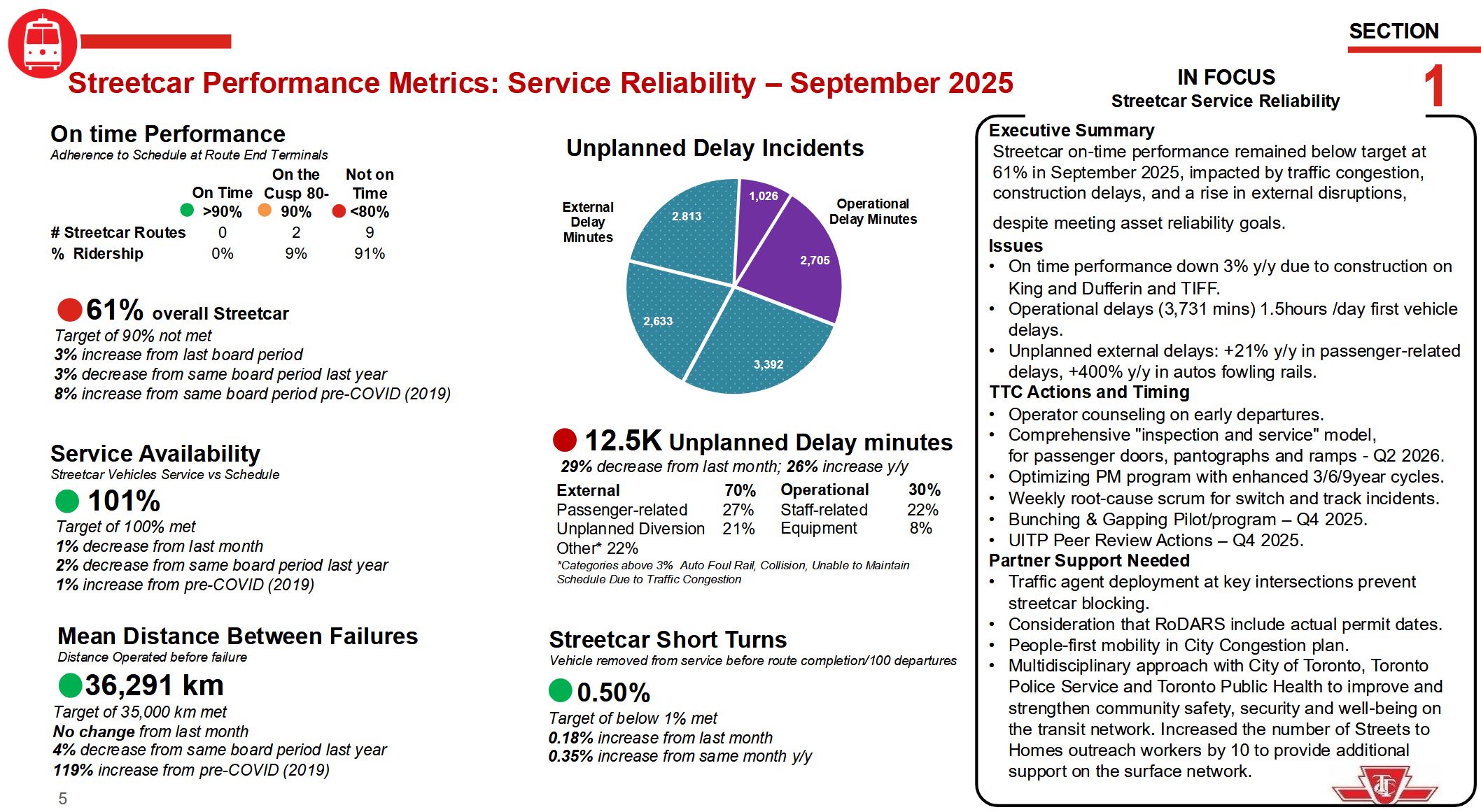
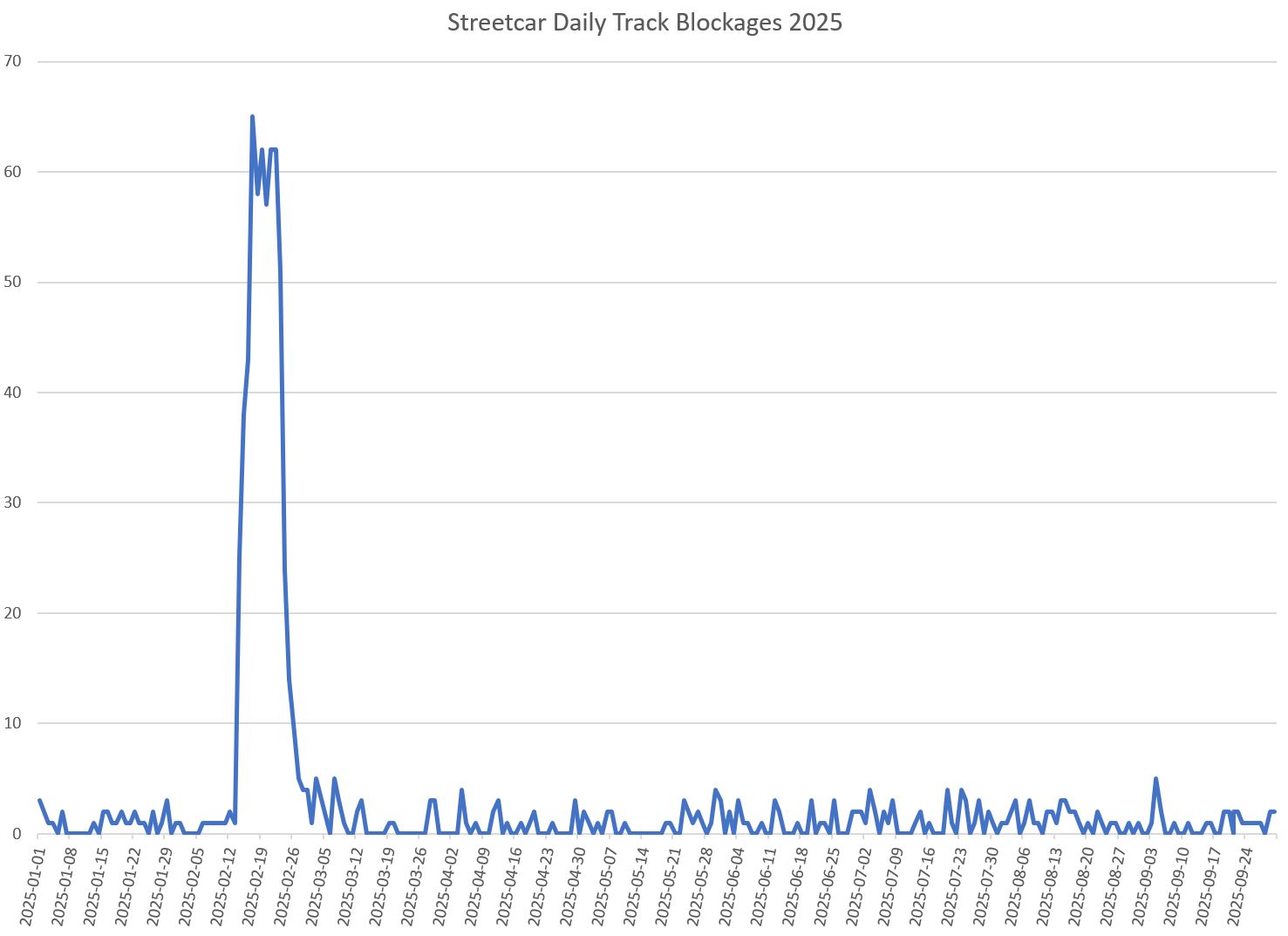
At the TTC Board meeting on November 3, management presented statistics on streetcar delays broken down by type of incident. TTC is quite fond of portraying external incidents, especially those related to congestion, as the root of (almost) all evil. The following page is from the CEO’s Report.
Note that external delays (turquoise) occupy the majority of the chart. During discussion of the problem of autos fouling rails, a passing remark by the Interim Chief Operating Officer piqued my curiosity when he said that there were many delays due to the winter storm.
This sent me to the TTC’s delay statistics which are available on the City’s Open Data site. There are codes for many types of delay including “MTAFR”, short for “Auto Fouling Rails”.
According to the “In Focus” box above there has been a 400% year-over-year increase in these delays, although they are styled as “fowling” implying a flock of chickens might be responsible for service issues.
Sorting the data by code and summarizing by date produces interesting results.
Between January 1 and September 30, 2025, there were 843 MTAFR events logged.
Of these, 586 fall between February 14 and 26 hitting a daily high of 65 on February 17.
These blockages were not caused by the typical traffic congestion, but by the City’s utter failure to clear snow on key streets.
105 were on 501 Queen
42 were on 503 Kingston Rd.
84 were on 504 King
93 were on 505 Dundas
186 were on 506 Carlton
3 were on 507 Long Branch
1 was on 508 Lake Shore
2 were on 509 Harbourfront
None were on 510 Spadina or 511 Bathurst
6 were on 512 St. Clair
A few dozen were on various night cars
The pattern here is quite clear: routes on wide roads or rights-of-way were not seriously affected, but routes on regular 4-lane streets were hammered. (How 511 Bathurst was spared is a mystery. At the time it was running with streetcars from Bathurst Station to King & Spadina, and with buses on the south end of the route.)
To claim that the 400% increase from 2024 is some indication of worsening traffic problems is gross misrepresentation of what actually happened. Although this is the CEO’s report and he almost certainly did not assemble the information himself, he wears this issue for having reported misleading data to the Board and public.
Direct comparison with published 2024 data is difficult because until 2025 the TTC used a much coarser set of delay codes that lumped many types of events under generic headings. There was a category “Held by” in which there were 625 incidents from January to September in 2024. The 843 MTAFR codes in 2025 are quite clearly not a 400% increase over 2024.
Whenever there is a discussion of unreliable service, we hear endlessly about traffic congestion. This definitely is a problem, but not the only one, and certainly not in the way presented by the CEO.
A question arose during the debate about the problem that performance stats are consolidated across all routes. Route-by-route service quality is presented in detail in the second part of this article for all streetcar routes. This shows that problems are widespread in the system, even on routes with reserved lanes.
As for the delay stats cited by the CEO, it is clear that we are not comparing September 2025 to one year earlier as the text implies, but using events from the entire year to date including a major snowstorm that had no equivalent a year earlier. The so-called 400% jump in delays from blocked tracks is due to snow and poor road clearance by the City.
TTC management owes the Board and the public an apology for blatant misrepresentation of the delay statistics.
The City of Toronto has announced that work at King & Dufferin is finished and the intersection will reopen to traffic on Wednesday, October 29 after 7pm.
Regular service will be restored on 29/929/329 Dufferin, and the 503 Kingston Road bus will be extended west from Joe Shuster Way (east of Dufferin) to Roncesvalles at 5am on Thursday, October 30.
TTC will test the new track and overhead during the week of November 3 and will restore 504 King and 508 Lake Shore services from their current Shaw/Queen diversion when the intersection is cleared for streetcar operation.
Meanwhile, the TTC CEO’s Report notes that six minute or better service will come to 505 Dundas and 511 Bathurst from 7am-7pm 7 days/week starting November 16.
The TTC has announced its services for the CNE for 2025 to operate from Friday, August 15 to Monday, September 1.
CNE Express buses will operate non-stop between Bathurst Station and Exhibition Loop, and between Dufferin Station and Dufferin Loop.
Extra service will operate on the 29 Dufferin and 929 Dufferin Express bus routes, and on the 509 Harbourfront and 511 Bathurst streetcar routes.
Other routes will change to accommodate the CNE services and traffic conditions.
63 Ossington buses normally loop at King via Strachan, East Liberty, Liberty and Atlantic. This will change so that buses loop via Fraser, Liberty and Atlantic.
503 Kingston Road streetcars will be extended west from Dufferin to Sunnyside Loop between 2pm-1am weekdays and 9am-1am on weekends.
510 Spadina streetcars will terminate at Queens Quay Loop until 7:30pm daily, and will run to Union Station afterward.
This is the third part of a series showing details of travel times in the Bathurst and Dufferin corridors.
For introductory remarks and a discussion of general issues, please refer to Part I.
The main part of this article contains the charts for the streetcar service on 511 Bathurst. Note that data for any bus extras has been omitted from these charts to ensure a presentation of streetcar-only speeds. Data from October 2024 and July 2025 are shown here to be outside of the period when the line was rerouted around construction at Fleet and Bathurst with buses operating a south-end shuttle service.
Thanks to a recent article about the proposed RapidTO lanes on Bathurst and Dufferin, A Contrarian’s View of Bathurst/Dufferin RapidTO, I was dumped on by several people notably on BlueSky in the type of exchange we are more used to seeing on X. The problem was compounded when several of my comments were incorporated in the now-discredited anti-bus-lane campaigns featuring AI-generated “spokespeople” for affected neighbourhoods.
The existence of those campaigns, however, does not invalidate my basic arguments questioning the purported benefits of the project.
While I was working on a series of articles reviewing the actual operating characteristics of 7 Bathurst and 29/929 Dufferin, the debate about red lanes started to heat up. I already knew from the analysis in progress that the issues on these corridors went well beyond parking, and in some cases were completely separate.
Both routes suffer from appallingly irregular “dispatching”, if we can call it that, of vehicles from their northern and southern terminals. Before service even reaches the proposed transit priority areas, the headways are erratic with gaps and bunching. This worsens as buses travel along routes. This happens all of the time, every day of the week. This is not a case of chronically late buses leaving at random times, and tracking data show that much of the service enjoys a reasonable terminal layover time.
A related problem for riders is that the scheduled service on 7 Bathurst is not frequent, compared to other routes in the city with reserved lanes. This compounds with irregular headways to produce unreliable service.
Although Bathurst was part of the “top 20” identified as possible RapidTO candidates, it was not part of the original RapidTO studies reviewing Dufferin, Jane, Steeles West, Lawrence East and Finch East. Lawrence East is only on that short list thanks to efforts of the recently departed Councillor McKelvie who has gone on to a new career as an MP. Bathurst rose to prominence thanks to the anticipated need for transit priority during the six FIFA World Cup games in 2026.
Even the overnight 329 Dufferin Night Bus, operating half-hourly when there is no traffic congestion, does not maintain regular headways. Buses leave terminals at Exhibition Place and Steeles within a narrow band of headways, as one would hope when they are running “on time” relative to schedules. However, just as with daytime service, bus speeds vary, and as they move along the route, the headways spread out. Midway along the route between 3am and 4am, half of the service lies in a 15-minute wide band, well beyond TTC Service Standards, and the other half lies even further from the target.
This is not a problem of congestion but of the lack of headway and “on time” discipline for night services. In turn this makes wait times unpredictable, and transfers between routes can fail because a bus is badly off schedule. Night service is erratic across the city despite political talk of its important role serving shift workers.
TTC Service Standards give considerable leeway to what is reported as “on time performance” and allow management to report better results than a typical rider would find credible. I have covered this topic in other posts and will not belabour the problems here. The “Standards” badly need revision, and along with them, the quality of service management.
This is not to say that transit priority is unnecessary, but that it will not achieve its stated goals without addressing underlying problems affecting far more routes than the Bathurst and Dufferin buses.
As for the Bathurst Streetcar proposal, this originates in the FIFA games. The TTC hopes to run very frequent service between Bathurst Station and Exhibition Loop with transit priority from Bloor south to Lake Shore where the route joins the existing right-of-way on Fleet Street. The question here is whether the installation should be permanent, or only for the period of the games.
The 511 Bathurst car now operates every 8-10 minutes, although the TTC has plans to improve this to every 6 minutes later this year. The route suffers from many delays at crossings of other streetcar routes thanks to the TTC’s blanket slow order on junctions where streetcars crawl through the special trackwork. Those of us with long memories (or anyone who has visited street railways elsewhere) know that this is a Toronto-specific restriction that grew out of problems with electric switch controller reliability dating back to the 1990s.
If service on 511 Bathurst is to be very frequent for the games, the TTC will have to design a mechanism for crew relief that does not include parking vehicles for extended periods. Operators need breaks, but this should not cause transit traffic congestion at terminals.
On a four-lane road, no parking will be possible with a 7×24 reserved streetcar lane. As with the proposed bus lanes, the issue is whether all-day reservation is needed, and what locations would work with shorter hours. The problem of enforcement is trickier because motorists think of middle lanes as “theirs” while the curb lane might come and go. There will also be an issue with any mix of local and express services, and which of these is provided by the streetcars.
The TTC has not published any service design proposals to indicate what the transit demands on the road will be. Many operational issues need to be sorted out for an intensive FIFA service, and much more than red paint is needed.
Toronto talks a good line on transit support, but this is not reflected in system-wide issues including irregular and crowded bus service, and a sense that growth, if any, will be doled out by a parsimonious Council. This directly contradicts claims for the future importance of transit in moving people around the city and supporting increased density on major routes.