As I began to write this on June 6 at 5:00pm, the TTC had not yet published the detailed memo of service changes for June 7. There is a web page listing World Cup related service changes, but no details about service frequencies. On an interim basis, I have used the electronic version of the June 7 schedules (GTFS data) as a source for info on scheduled service. On game days, there will be additional service as needed.
Updated: The TTC issued the detailed service memo in the early hours of June 7. Thanks to those burning the midnight oil to get this out. This article has been updated to consolidate info from the memo. Note that June service changes for subway, LRT and bus routes will not occur until June 21, and these will be covered in a separate post.
307 and 311 Bathurst night services: Stopping arrangements at Bathurst and St. Clair West Stations clarified.
Streetcar route maps added at the end of the article.
301L route clarified to include extension to Dufferin Loop.
Streetcar vehicle allocation tables added.
Spreadsheet of detailed changes added. Revised to include 929 Dufferin Express.
List of destination sign changes added.
Bathurst Corridor
Night service on 307 Bathurst bus will be shortened to end at Bathurst Station. Service south to Exhibition will be provided by a 311 Bathurst night car running from St. Clair to Exhibition Loop.
Service on 511 Bathurst will be improved (see table later in this article).
Updates:
307 buses will loop through Bathurst Station, but will lay over and serve a new stop northbound on Bathurst at London (opposite the station).
311 streetcars will run out of service through St. Clair West Station.
Spadina Corridor
Service on the 510 Spadina streetcar will be shortened to turn at Queens Quay Loop. Service to Union Station will be provided by 509/309 Harbourfront and by 310 Spadina. (Corrected)
Waterfront
Service on 509 Harbourfront will be improved (see table later in this article), and a new 309 Harbourfront night car will operate.
Dufferin Corridor
Service on 929 Dufferin express will be added on Sunday evenings on Game Days running every 8 minutes.
King Corridor
Service will be improved on 504 King. On Game Days, the 504B from Broadview Station will turn back via a loop of King, Queen and Shaw without serving Dufferin Loop. See detailed map and schedule in the schedule section later in this article.
Queen / Lake Shore Boulevard West
507/501/301 Long Branch service will be replaced by buses due to construction at Long Branch Loop.
Two branches of the replacement bus service will operate:
507 from Humber Loop to Long Branch Loop via Park Lawn.
507M from Humber Loop to the Humber Bay Shores area looping via Marine Parade Drive.
This configuration will run until Labour Day weekend. In September, 507 streetcars will return as far as Kipling Loop, and the 110 Islington South will be extended west to Long Branch Loop.
508 Lake Shore streetcar service will be suspended for the summer season returning after Labour Day.
Updated: 301L night buses will operate from Long Branch Loop to Dufferin Loop via Queen and Dufferin providing an overlap with the 301 Queen night car.
See map in the schedule details later in this post.
An online meeting of the Stakeholder Advisory Committee for Waterfront East transit was called for May 13. Normally these events provide significant new information about the project, and they are usually just ahead of a new round of public consultation or reports to Council.
That was certainly not the case for this round. What information was conveyed has already appeared in previous announcements and reports, and the presenters from Waterfront Toronto and the City’s Transit Expansion Office were loathe to part with details, assuming they knew anything about the project.
Notable by its absence was any detailed discussion of project phasing: which chunks of the Waterfront East will be built first and what the interim service plans will look like. Any further updates have been punted to early 2027 conveniently beyond the election.
I could not help remembering a conversation with then-Mayor Tory at TTC’s 100th Anniversary celebration at Hillcrest in 2021 where he was quite firm that the Waterfront line was a “priority” for him. We are still waiting.
The meeting was one of those embarrassing affairs with roughly the same number of public participants as staff. Notable by their absence was anyone from City Planning, the TTC or any Councillors’ office.
What was presented is already known:
There is now $3-billion committed by Toronto, Ontario and Canada to fund the project.
Council has authorized continuing with design work as well as “early works” this year in preparation for construction next year. The early work is construction of the ductbank on Small Street north from Queens Quay to Lakeshore to the site of a future substation to be incorporated in a new development there.
Planned construction will be on Queens Quay east but not all the way to Cherry, and it is unclear just how much will be done in 2027.
The opening date, as repeatedly stated, is now linked to the 2032 occupancy of new buildings on Ookwemin Minising (formerly Villier’s Island). It is almost as if all of the development already on Queens Quay does not exist or need better transit service as soon as possible. Reading between the lines, this will be the tail end of a service running east across Queens Quay from Spadina, but not yet to Union Station.
There is no staging plan yet. Obviously an east-west link on Queens Quay is needed first and that is impossible without interrupting service at Bay to Queens Quay and Union Stations. There is no projection for the duration of work that will first shut down streetcar service completely, then reopen only for through east-west travel pending completion of the Union Station rebuild.
Also uncertain is the timing of the branch north via Cherry to connect with Distillery Loop. This would provide an alternate link from the east, but there are timing issues with both Metrolinx work (Ontario Line), and the relocation of the Gardiner/DVP ramps. The legacy Cherry Street Tower just north of the rail corridor also needs to be moved.
This meeting did not discuss the many issues related to the Bay Street tunnel including work needed to expand the streetcar loop and to improve connections to the Ferry Docks at Queens Quay. It is ironic that hours before I wrote this, the City announced the names of two new electric ferries that will substantially increase capacity to the Toronto Island.
At the very least, some of these events already have dates or tentative plans, although they must be stitched together into an overall project. The “players” are notorious for changing plans without notice, and there is no guarantee a plan formed today will last until tomorrow. All the same, the public and politicians deserve to know what all the parts are and what issues might arise. We have $3-billion burning a hole in our pocket, but no idea of how to spend it or even if it will cover all of the planned work.
With the opening off to 2032 and full operation to Union beyond that, other projects potentially serving the waterfront also should be discussed including the Broadview extension south to Commissioners, and the extension of the WERTL east to at least Broadview. Waterfront planning has many moving parts, and nobody seems willing to unpack the complete list let alone speculate on costs and timeframes.
I had a real sense that the presenters were clearly the City’s “B” team, the kind of people one sends to a public meeting with a script to say as little as possible. Either they did not know what the options and decisions are on the table, or they were not telling even with repeated chances to clarify. SAC members had expected an update on staging this spring, but now we (and by extension Council and voters) must wait until 2027 after the election.
In some doublespeak worthy of Metrolinx we learned that the former Waterfront East LRT has been renamed the Waterfront East Rapid Transit Line. The purpose is to distinguish it from Lines 5 and 6, with the WERTL being an extension of the existing streetcar network. A rose by any other name.
Years ago, the TTC’s planning function was spun off to the City’s Transit Expansion Office, a group that has never felt like an “A” team. They seem to have taken over this project from the City’s Planning Department who gave a sense they actually knew what was happening having been involved for so long in redevelopment of the eastern waterfront.
Toronto deserves an open and honest discussion of waterfront transit issues, not a once-over-lightly presentation with almost no detail.
Work on this article began before the March 30 announcement of tripartite funding for various housing and transit projects. Comments about this have been incorporated here.
At its meeting of March 31, the TTC’s Strategic Planning Committee will consider two reports relating to the financial future of both the Operating and Capital budgets.
The report on a long-term plan is less than its title might suggest in that it merely launches a process to develop a plan, but does not propose anything concrete. Some members of the TTC Board have wanted to see a long-term plan and options for years, but nothing usually comes of this beyond rehashing information we already know from the annual budget cycle. City Council cannot formulate capital and operating budget plans without a clear indication of the needs and trends at its most expensive agency.
A related problem is that conflicting indications come from the Council and the Mayor about spending priorities, and some TTC plans are closely linked to Provincial projects such as the North Yonge subway extension. Major committed projects have already claimed much of the announced Federal funding, and substantial additions will require net new funding.
That, in turn, requires the TTC and Council to think carefully about priorities rather than asking for money project-to-project on the assumption that money will always be available. In the context of high Provincial debt and considerable spending on transit, plus a refocus of Federal priorities and an attempt to decrease spending, Toronto is unlikely to receive everything it wants.
Short-Term Planning
Short-term planning placed the TTC in a very difficult position.
The short-term balancing of the TTC’s financial pressures would not have been achieved without a substantial City subsidy in recent years, including the Ontario-Toronto New Deal providing three-years of operating funding support, and project specific capital grant funding from the provincial and federal governments.
For instance, the injection of $5.1 billion in the 2025-2034 Capital Plan, which was predominantly city funding, reduced the TTC’s state-of-good-repair backlog by $3.9 billion, or nearly 50%. However, fleet plan changes, asset condition assessments and cost estimate increases have increased the SOGR backlog in the 2026-2035 Capital Plan to a projected $6.1 billion at the end of the 10-year planning window. Funding for new trains, buses and streetcars by other orders of government addressed immediate fleet needs, and the operating support through COVID, have kept the system going. While these efforts had significant impact in the immediate term, the TTC still has a long-term financial problem due to a fiscal framework that has not evolved at the same pace as the scale, complexity, and expectations of a world class transit system.
This cycle of finding immediate term solutions to the budgetary pressures of the organization is one repeated annually. With each successive year the balancing act produces increasingly limited opportunities to find new efficiencies and revenue generation opportunities. The TTC’s aging assets continue to drive state-of good repair investment needs to maintain existing levels of service, while struggling to fund capacity enhancements to keep up with growth. [Long Term Plan, p. 1]
As things stand, the projections for Operating and Capital Budgets assume very modest growth in demand, at least in the short term, but there is a long list of projects, mostly unfunded on the Capital side both for State of Good Repair (SOGR) and to accommodate projected demand growth. Rapid transit extensions now underway only include provision for fleets at the level needed to serve current demand, but not the extra trains to increase capacity nor the maintenance facilities to house the expanded fleets. Drawing lines on maps requires not just tunnel construction, but consideration for how the network will operate and what effect extensions and new lines will have on the existing network’s operations.
With all the focus on a few rapid transit projects, there is the much larger issue of subway and surface fleet renewal, not to mention infrastructure work. Any plan to increase service and ridership substantially places an additional load on the Capital budget not to mention the Operating budget to actually deliver new service.
Fare Revenue Will Not Pay For Capital
Fare revenue from ridership growth did not pay for expansion even when the cost recovery rate was 70%. Now that it is below 50%, the effect of additional service is even more acute. We cannot talk about system expansion and moving more people with transit if we are not prepared to pay for it.
Transit funding in other cities comes from a variety of sources as detailed in the jurisdictional review. Toronto’s problem is that actually levying most of these requires cooperation from senior governments, notably Ontario where new taxes or fees of any kind are not welcome. In at least the medium term, Toronto will have to make do with existing funding schemes while hoping/lobbying for increases.
Options For Ridership Growth
The other side of this dilemma is that Toronto has never been presented with options beyond modest business as usual transit service. We do not know what growth and service quality we might aim for because annual budgets only scrape by to keep the system running.
While ridership growth is essential to long-term sustainability, on it own it is insufficient to close the structural fiscal gap without complementary changes to funding, fare policy and cost structures. As a result, other options and strategies must be identified. Recognizing this, at the January 23, 2026 meeting, the City of Toronto’s Budget Committee directed City staff to work with the TTC to develop a multi-year operating budget that both supports ridership growth and addresses the underlying financial pressures.
Growing ridership and increasing the mode share of public transit trips will require additional levels of investment in both service and capital beyond what is currently projected and may demand consideration of other sources of revenue and/or fundamental changes in policy with respect to how transit is prioritized within the City. [p. 3]
The report proposes that various scenarios be developed for levels of future growth and service. This will inform future budgets, but not immediately. A four-phase program is proposed:
Jurisdictional review of major transit systems: See the attachment linked above.
Scenario development and long-term analysis
Balancing strategies including cost containment, fare policy including enforcement, funding, and capital priorities
Recommendations and implementation roadmap
There is no discussion of the range of options that might be considered, nor is there a proposed date to report back. Obviously major change will not occur overnight, but short-term plans should explore what can be achieved within existing resources (fleet, infrastructure) and at what cost to get more out of resources the TTC already owns. Further out, no rapid transit growth will come online until the early 2030s, but the surface system should not be ignored waiting for new trains to roll into Scarborough, Richmond Hill and Thorncliffe Park.
In parallel there is the TransformTO plan which has a very aggressive target for shifting travel away from cars. It includes a massive increase in transit service that will not be achieved overnight even assuming Council approves this and funding is available. The TTC Board and Council need to make hard decisions about the scope of transit expansion, and not just a few rapid transit lines, they are prepared to undertake.
Once again, Middle-East war has exposed economy to rising fuel prices. What this will do to economic growth and transit demand remains to be seen. Toronto is at least in the position of owning a large, if not entirely adequate, transit network serving a goodly chunk of demand. However, this is historically focused on downtown-oriented trips, with considerably less support for the more numerous trips between suburban areas.
Ontario bears some responsibility here too because for decades GO Transit’s downtown focus worked against better use for inter-regional trips, and support for local and regional bus service has not encouraged large-scale growth. Calls for us to “do something” to relieve the high cost of fuel, such as free transit, ignore the fact that transit simply is not present, or is too small-scale, to support a major shift of auto to transit travel. Moreover, this only addresses the cost of driving where transit is an option, not the much wider question of the wider economic effect of higher fuel costs.
The March 30 Announcement
The Federal, Provincial and Toronto governments announced funding for various transit projects, as well as tax relief for some new housing.
The first important point about this is that it affects only the TTC Capital budget, but provides no new support for transit operations. Moreover, none of this announcement addresses the TTC’s unfunded capital backlog. Note that Waterfront East is not part of the TTC capital plan.
The Federal contribution to several transit projects has been confirmed, but this is not “new money”, only the formalization of previous announcements. These projects are: Ontario Line, Eglinton Crosstown West Extension, Scarborough Subway Extension, Yonge North Subway Extension and Hamilton LRT. These are Metrolinx, not TTC, projects.
In the name of stimulating housing, municipal Development Charges will be reduced with the gap made up by transfers from other governments. This benefits housing prices, but has no effect on transit to the extent that TTC plans include a provision (albeit declining) for DC revenue as a capital funding source. The only change is which pocket the money comes from, tempered by the hope that replacement DC funding will match what might otherwise have been expected.
The Waterfront East transit line will be funded at $3-billion with one third coming from each level of government. Any overruns will be the City’s responsibility. Now that funding is announced, the next stage of design can get underway. Waterfront Toronto expects to reveal staging plans for construction soon to Council and to community stakeholders.
Readers with long memories might recall the early days of plans for a new streetcar order including discussions about how large a vehicle should be purchased. A major concern at the time was the possibility that the TTC would change schedules and run less frequent service with the larger cars just as they had when the articulated version of the CLRV (the previous generation of cars) arrived in the late 1980s.
That concern was softened by a TTC claim that service would actually improve. Peak periods would see slightly less frequent service, but a net increase in capacity, while off-peak periods would see little change in frequency effectively doubling the capacity of service. At the time, crowding was a big issue and this persisted right up to the pandemic in 2020, by which time all of the old cars had been retired. The management proposal was approved in July 2013.
As the CLRV/ALRV fleet aged, there were problems with reliability of older cars and the need to operate buses on some lines thanks to a shortage of working vehicles. Some repairs were done at considerable cost, but these were more cosmetic than a true life extension.
Moving forward to 2026, there has been a lot of talk of restoring pre-pandemic service levels. TTC fudges the numbers on this in many cases citing vehicle hours operated, not actual service frequencies which have been degraded by longer travel times.
(For example, if a round trip, including terminal layovers, takes two hours or 120 minutes, then 20 cars will provide a 6-minute service. If the round trip gets longer but no cars are added, the service is less frequent, but the number of vehicle hours stays the same. From a rider’s point of view, service is worse, but from a budget outlook, there is no change. This is at the heart of the discrepancy between TTC service claims and rider experience.)
After years of changing service levels and demand, the TTC’s Five Year Plan foresees a return to six minute headways, at most, as a new standard for daytime service. This has been rolled out on some routes over the past year, but not all.
Already at 6 minutes or better: 504 King, 510 Spadina
Improved to 6 minutes: 512 St. Clair (Sept/25), 511 Bathurst (Nov/25), 505 Dundas (Nov/25)
Pending, but with no committed date: 501 Queen, 503 Kingston Road, 506 Carlton, 507 Long Branch.
The Five Year Plan (at p. 4) includes provision for extra spending in 2027 and 2028, but this is not tied to specific routes. There is nothing in the Plan for 2026.
A related issue is the size of the streetcar fleet. Leading up to 2020, the issue was how many cars were actually available, and some service cuts flowed directly from this. With the recent delivery of 60 additional cars, fleet availability should not be an issue although service can still be limited by a lack of operators. The TTC currently schedules 163 cars at peak out of a fleet of 264. If services now operating with buses due to construction were also using streetcars (503 Kingston Road and the Broadview branch of 504 King), the peak requirement would rise to 178. Allowing for maintenance spares this would drive the total requirement to 214 leaving 42 surplus for service improvements (allowing for 8 spares).
February 2026 Schedule PM Peak
Full Streetcar Service
Possible Service
Peak Requirement
163
178
220
Spares at 20%
33
36
44
Total Requirement
196
214
264
Fleet
264
264
264
Surplus
68
50
0
The problem, of course, is that the TTC barely has budget headroom to operate existing services let alone increases.
In theory, some of the surplus cars will eventually operate the Waterfront East LRT extension, but that service is at least 8 years away even assuming Toronto finds the money to build it. In any event this will not require anywhere near all of the current surplus fleet. Another issue is that the “streetcar network” has not operated with 100% streetcar service for a few decades thanks to various construction projects and vehicle shortages.
There are parallel issues with the bus network, but they are complicated by issues of vehicle reliability and the need for a spare pool to cover the unreliable LRT service primarily on Line 6 Finch West. I will turn to the bus fleet in a separate article.
Back in 2013, the TTC proposed how it would operate with the new streetcar fleet. During peak periods, headways would widen particularly where existing service was very frequent. Notably on 501 Queen, there would only be a slight widening of the time between cars in the AM peak and no change in the PM peak. This reflected the fact that Queen was already running with the 75-foot long ALRVs and needed more capacity.
In the off peak, most routes would see no change in service level except for 510 Spadina due to its already frequent service of 50-foot CLRVs that could not be sustained at terminals with the larger new cars.
The overall fleet plan showed a buildup to a peak requirement of 168 cars plus 20% spares.
This plan gave a bright future for streetcar service and capacity growth, but things did not work out that way. Service today is generally lower than originally projected for the new fleet, and part of this reduction is due to slower operating speeds and greater provision for terminal recovery time even on routes with reserved lanes.
A related question is the effect that less frequent service has had on ridership. There is a post-pandemic slump on the streetcar system in part due to work-from-home for office jobs and remote learning for post-secondary students. However, even allowing for the pandemic era drop, the problem remains in attracting riders back to transit when streetcars are less frequent and slower, compounded by chronic problems with service reliability. Charts tracking streetcar ridership from 1976 to 2024, the last year published by TTC, are at the end of the article.
These routes are in the part of Toronto where transit riders should be easy to win, but a long decline in service frequency discourages those who have the option to use another mode including private autos, ride hailing or cycling. Service cuts during economic downturns do not magically get reversed as times improve, and ridership that might be wooed back to transit instead faces less reliable service and a political attitude that favours big spending on subway projects, not surface transit.
The remainder of this article looks at each route in detail to see how the actual service changed from the 2014 plan through the 2020s to today comparing:
The 2014 headways for AM Peak, Midday and PM Peak in the management proposal.
The proposed headways after routes converted to Flexity streetcars.
The actual scheduled service in January 2014, January 2020 (just before the pandemic) and February 2026. Driving times are shown separate from terminal recovery times to illustrate how each component has evolved.
Quite notable on many routes is the growth in both scheduled driving and terminal times. Although it is common in the mid-2020s to regard extended travel times and traffic delays as a recent, post-pandemic phenomenon, this pattern started earlier and is evident in 2014:2020 comparisons. Surplus time, it was argued, would prevent short turns, a claim that is demonstrably false as most riders know on a daily basis, but it slows service, wastes resources and forces wider headways.
The Design Review Panel at Waterfront Toronto recently considered the proposed design for the surface portion of the Waterfront East LRT and Queens Quay reconfiguration now that it has reached the 60% level.
Updated June 6 at 4:10pm:
The presentation decks from the meeting will not be posted on Waterfront’s site, but I have set up a page on this site where those interested can access them. There is far more information about the designs in the presentation decks than I have included here.
This article focuses on aspects of the design affecting the Waterfront East LRT project (WELRT), one of several major City of Toronto priorities that is not yet funded. Toronto hopes to see money for this in the Federal government’s collection of key infrastructure projects, but nothing is certain.
How much of this design will survive the inevitable “value engineering” and reduce acres of green to boring concrete remains to be seen.
Responsibility for this project is split:
The segment from Union south to Queens Quay is a TTC project, but work on that has stopped at 30% design pending certainty about funding.
The segments on Queens Quay East, Cherry and Commissioners are split between the Port Lands Flood Protection project (funded) and the WELRT (not funded). Waterfront Toronto is responsible for design of these segments.
Two early works, shown in light blue in the map above, are the reconfiguration of the Yonge Street Slip and the extension of Queens Quay east from Small Street (where it now veers north) to Cherry Street. Readers may recall the overblown Sidewalk Labs proposal for the land around Parliament Slip and south onto Ookwemin Minising (formerly Villiers Island). This design round is far more in keeping with the style and scale of Queens Quay West’s renewal.
In its initial implementation, the WELRT will go as far as the Commissioners Street crossing of the new Don River. Tracks on Cherry will be extended south from Distillery Loop through a new portal under the rail corridor to connect with the line on Queens Quay east from Bay Street. Future expansion in various ways is possible, but how soon this might occur is anyone’s guess given the state of transit funding and the uncertainty of land development schemes. Options include:
Southern extension via Cherry to Polson Street
Eastern extension to a planned Broadview extension and thus to:
Leslie Barns via Commissioners
East Harbour Station on the Ontario Line and beyond to existing trackage on Broadview at Queen Street
This was a design presentation, and issues of constructability and eventual implementation of the WELRT are beyond its scope.
Ontario unveiled its 2025 budget on May 15. Although it speaks of “Approximately $61 billion over 10 years for public transit”, by far the lion’s share of this spending is for projects already underway in the construction and design stages.
All of this is for capital expansion and renewal, and nothing has been announced for day-to-day improvement of transit service.
GO Transit
The budget cites:
The Hamilton-Niagara through service connection at West Harbour Station which is already in service.
The proposed Bowmanville extension which has been announced before, but is only barely underway at the “early works” stage. This extension has physical alignment issues.
GO 2.0 includes “delivering all-day, two-way service to Kitchener and Milton, building new GO stations across the region and advancing planning to unlock potential new rail corridors through midtown Toronto, Etobicoke, York Region and Bolton.” There are no dates attached, and some of these have been on maps for a very long time. Notable by its absence is any mention of electrification.
A total of $850 million to refurbish GO Transit rail coaches at the Thunder Bay Alstom the North Bay ONR facility. This work is already announced. The cars may receive convenience upgrades such as “charging plug ports, cup holders and improved Wi-Fi”, but the long-term retention of these cars indicates that the operating model for GO electrification, if and when it occurs, will have a large component of locomotive-hauled trains rather than electric multiple units.
Subways
Subway projects in the budget are:
Ontario Line (under construction).
Eglinton-Crosstown Western Extension (under construction).
Yonge North to Richmond Hill (procurement underway).
Sheppard Subway Extension (planning, consultation and business case preparation underway). Notable in the map below is the absence of a line east of McCowan where there is a conflict with the City’s Eglinton East LRT project and with maintenance yard property requirements.
New subway cars for Line 2. Provincial funding for these trains has been in place for some time. What is not yet funded are trains for service expansion beyond pre-covid 2019 levels. Trains for the Yonge North and Scarborough extensions are included in those projects. The TTC is in the Request for Proposals process for new trains, but this has been skewed by provincial statements that the work should go to Alstom’s Thunder Bay plant.
Yes, they seem to have forgotten the Scarborough Subway Extension (now under construction) in the text although it is included in the map below..
East Harbour Transit Hub
The hub at East Harbour Station, near the point where the Lakeshore East GO line crosses the Don River, will eventually serve GO Transit, the Ontario Line, and the local streetcar/LRT system via the Broadview Avenue Extension and a link west via Commissioners Street.
A substantial portion of this project is funded by the City of Toronto as a remnant of John Tory’s “SmartTrack” plan.
Light Rail Projects
Hamilton LRT: This is in early states with procurement underway for Civil Works and Utilities.
Hazel McCallion (Mississauga) LRT: Construction is well underway for the initial phase of this project, and the Province is studying whether the extension into downtown Brampton should be tunneled.
Ottawa LRT: The Province is studying a potential upload of the Ottawa LRT “to help reduce costs for Ottawa taxpayers”. What implications this might have for future network operation and expansion is not clear.
Eglinton Crosstown and Finch West LRTs: “Major construction for both projects is now complete. Metrolinx continues to focus on safety and operational readiness testing, as the projects advance toward revenue service.” There is still no commitment to opening dates, and we are getting close to the three-month lead-time required for a go/no-go decision for an early fall 2025 start of service. Meanwhile, TTC has begun the process to update subway train announcements and maps to reflect the new lines.’
There is no mention of the Eglinton East or Waterfront East projects. In a recent letter, Mayor Chow asked the Federal government to contribute 1/3 to these schemes, but there is no indication of support in the Provincial budget.
Updated Feb 18, 2025 at 12:55pm:A TTC report with more extensive information about the proposal was posted today as part of the Board’s agenda for February 24. Information from that report has been merged into this article.
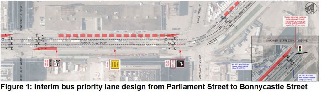
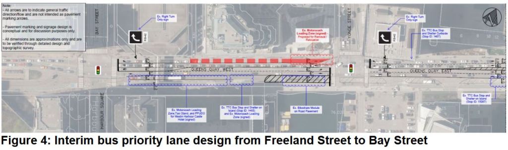
In the long wait for any kind of transit improvement for the eastern waterfront, the City of Toronto and TTC now plan to install reserved bus lanes on Queens Quay between Bay and Parliament Streets. A short stretch is also proposed for Front Street between Bay and Yonge Streets eastbound.
The proposal would add red lanes:
eastbound on Queens Quay from Jarvis to Parliament,
westbound on Queens Quay from Parliament to Bay, and
eastbound on Front from Bay to Yonge.
The Martin Goodman Trail (cycling) will not be affected. A new westbound right turn lane will be added on Queens Quay at Jarvis. Parking spaces will be removed on Front east of Bay Street.
Updated Feb. 18, 2025: Maps of the proposed changes to Queens Quay and to Front Street are included in the TTC report.
There is more reservation westbound on Queens Quay than eastbound, and that is the direction with the worst congestion problems. The south side offers less space for creation of a bus lane, and in some cases there might be lane narrowing to free up space for the north side.
The reserved lane westbound is generally in the curb lane, but between Sherbourne and Jarvis it will be the second from the curb. The curb lane will be dedicated to right turns given the high demand for this at Jarvis. With this change, the westbound stop at Richardson Street will be removed. The lane disappears between Cooper and Yonge Streets due to space constraints, but reappears west of Yonge in an area now used for Motorcoach loading.
On Front Street, although this is a “red lane”, the intent is for storage of up to five buses, not for speedy travel. Moreover, the bus stop will be shifted further east adding to the walking distance for riders to Union Station.
The accessible loading zone will shift west behind the bus layby. The layby area is now occupied by ten parking spaces which will be removed. This area will be shared by 114 Queens Quay, 19 Bay and 202 Cherry Beach.
For further details on the proposal, please see the TTC Report at pp 12-15.
[End of Feb. 18 update]
The area is now served, albeit infrequently, by a mix of routes that can often be snarled in traffic. The intent is to save up to five minutes travel time between Bay and Parliament. The reserved lanes will also host future improved service to developments on the eastern waterfront pending construction of the planned, but long-delayed Waterfront East LRT.
In May 2024, 114 Queens Quay replaced the southern end of 19 Bay which now terminates at Front Street. From a loop via Front, Yonge, Wellington and Bay it runs south on Bay then east on Queens Quay into the Port Lands. The 114 operates every 10 minutes in peak periods, 12-15 minutes at other times. This is the primary route serving waterfront developments.
202 Cherry Beach (summer months only) runs from the same downtown loop as the 119 and follows its route as far as Parliament where it shifts north to serve the Distillery District. The 202 then turns south via Cherry Street to a loop at Cherry Beach. In summer 2024, this route operated every 20-30 minutes with no service in the AM peak.
75 Sherbourne has a south end loop via Sherbourne, Queens Quay, Jarvis and The Esplanade. It operates every 6-8 minutes during weekday daytime, and 20 minutes or more during most other periods.
65 Parliament loops at the George Brown Campus on Queens Quay. (This loop was the former eastern terminus of 19 Bay). It operates every 8-9 minutes during peak periods, 13-15 minutes at other times. Overnight service is provided every half hour by 365 Parliament.
The service between Union Station and the waterfront on 114 Queens Quay is not on a par with other routes that have dedicated lanes, and real improvement in accessibility of the waterfront will only come with much better service and eventually the LRT link via the Bay Street tunnel. A recommendation and decision on staging of the LRT should come to Council and the TTC later in 2025, but the project is not funded.
Public consultation will be held via a survey that is active until Thursday, February 20, and via three sessions:
Tuesday, February 18, 2025, 7:00 – 8:30 p.m. This session was held via webex.
Wednesday, February 19, 2025 at the George Brown Waterfront Campus:
3 – 5 p.m. A pop-up event will occur in the main lobby.
7:00 – 8:30 p.m. An in person session in the 2nd floor main auditorium, room 237.
This page will be updated when more information is available.
The July 17 Board meeting was extraordinarily long thanks to three in camera items, plus extended discussions of the CEO’s Report and of use of buses as homeless shelters during the winter.
The confidential session dealt with:
A collective bargaining update for two small groups of customer service and operations supervisor employees.
An update on advice from External Counsel. On a recorded vote, this was adopted with all Board members except Councillor Saxe in favour. As of the publication of this article (July 28), there have been no leaks about the subject of this report.
An update on the fare modernization program including the status of the Presto contract. The report was also discussed briefly in the public session later in the meeting.
The public meeting included:
The July 16 storm, flooding and hardening of infrastructure against climate change.
New subway trains and federal funding announced earlier the same day (July 17).
Prioritization of State of Good Repair projects. This item received scant attention although the report contains much interesting background on capital plans.
Safety on the TTC.
Use of shelter buses.
Transit network expansion update.
Fare Compliance Action Plan: See the updated version of my previous article on this report which includes the debate at the Board meeting.
Not discussed was the issue of hydraulic fluid leaks from subway work cars of which one quarter are still out of service. A report is supposed to be coming to the Board soon. It is not clear how much this situation is affecting the TTC’s ability to stay on top of track maintenance issues and the growing list of slow orders for track that cannot be safely operated at full speed.
Work on the Waterfront East LRT crept forward with the approval by Toronto’s Executive Committee of funding to continue design work, and of a tentative project plan. This must be endorsed by Council at its meeting of November 8-10, 2023.
Updated: Shortly after this article was published, the City of Toronto replied to questions I had posed about their report. The replies are integrated with the text of the article.
A combination of several factors push the completion date of this project, assuming that it receives full funding from provincial and/or federal sources, out into the 2030s. There is a danger that a so-called transit first community will actually see much of its redevelopment occur before adequate transit is in place to support it. Conversely, absent the transit service, some planned projects may simply sit as empty lots because they are not viable without it.
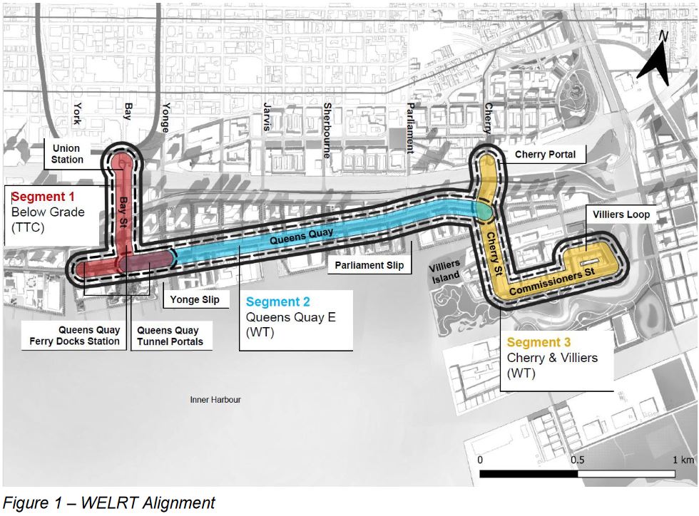
Segment 1 (red) contains the Bay Street tunnel and the portals at Queens Quay where streetcars will surface. The existing west portal will be renovated and the new east portal added. Plans for decorative canopies have been dropped from the plan as a cost saving measure. This segment is under the TTC’s control for design and construction.
Segment 2 (blue) consists of the surface running on Queens Quay East to a revised intersection at Cherry Street which is realigned to the west. This segment primarily involved the reconfiguration of Queens Quay East similar to what already exists on Queens Quay West. (For details please refer to previous articles.)
Segment 3 (yellow) includes the southerly extension of trackage from Distillery Loop under the GO corridor, along a realigned Cherry Street, and east on Commissioners St to Villiers Loop (which is actually an around-the-block terminus, not an off street loop).
There are impediments to the work on segments 1 and 3 that dictate the timing of various works. The many delays in actually launching the WELRT project put other works in the same area in conflict that might otherwise be avoided notably the Ontario Line and the Gardiner/DVP realignment. The Bay Street tunnel has become more complex due to updated fire codes and the need to serve many more passengers than the Union Station Loop does today. Still outstanding is the redesign and expansion of Queens Quay Station and a link to the Island Ferry Docks which has been dropped from the project, as of the last update in April 2023.
The recommendations approved by Executive Committee are that:
Council approve the alignment shown in the report.
Council approve advancing design for the entire project, except segment 1 (underground), to 60%.
Council approve
completion of environmental approvals,
undertaking of a traffic management plan to address interfacing the WELRT an other projects’ construction, and
design and coordination of the scope for the WELRT at the Cherry Lake Shore realignment, the Inner Harbour Tunnel at Jarvis, and the Hydro One relocation project at Cherry Portal.
Council authorize an increase to the Transit Expansion Division’s Capital plan of $63.6 million in 2024-2026.
Council direct the Executive Director of the Transit Expansion Division to report back at some point, unspecified, in 2024 with an update.
The estimated cost of the full project is $2.57 billion over a ten-year period assuming that full funding comes in Q1 2024, and the design work proposed in this report starts immediately. Any delay is a notable concern in an era when construction material and labour costs are rising quickly. It is not clear whether the figure cited is in current 2023 dollars, or includes inflation to the point the money is actually spent. I await clarification on this from the City.
Updated: The City of Toronto advises that:
The City is using as-spent dollars with future escalation included to the anticipated year of the expenditure. The cost estimate relies upon timely funding to meet the implementation schedule which is used as the basis for these inflation numbers.
Email from City of Toronto Media Relations, Nov. 2/23
The reason that the underground segment is excluded from approved design in recommendation 2 above is that this segment is proposed to be executed with a design-build contract where the detailed design will be undertaken by a contractor who is familiar with work in an underground environment.
Updated: This also keeps the design cost off of the City’s expenses for the moment. The City of Toronto advises that:
As noted in the staff report, staff are not recommending advancing the design of Segment 1 to 60% due to the City’s current financial pressures.
Email from City of Toronto Media Relations, Nov. 2/23
The project is subdivided into three parts:
Union Station Loop, $932 million.
Remainder of project except Cherry North, $1.3 billion. Includes East and West portals on Queens Quay, Queens Quay Station, Yonge Slip infill, Queens Quay East track from Bay to Cherry, Cherry Street south, Commissioners Street and Villiers Loop.
Cherry North connection to Distillery District, $337 million, to be completed as a separate future phase.
The scope of work planned at Queens Quay Station is unclear because at the last update, much of this work had been dropped (platform expansion, link to adjacent building, link to ferry docks). I have asked the City for clarification of this.
Updated: The City of Toronto advises that:
The current scope for Queens Quay Ferry Docks Station is related to the station access upgrades (upgrade of the west entrance to improve accessibility) and it is part of the Segment 1 scope.
Email from City of Toronto Media Relations, Nov. 2/23
For the benefit of latecomers to the Waterfront East project, I have included a history at the end of the article. The idea goes back at least to the 2003 Central Waterfront Plan, and has languished without strong political support ever since the Ford era when all focus shifted to subways.
The greatest challenge was and remains that waterfront transit is not “important enough” to many on Council and lacked key leadership from the Mayor’s office through the John Tory era. Under Mayor Chow, it will compete with many other projects for priority and funding both for transit and in the wider context of City projects.
Three decades after the Central Waterfront Plan and a 2011 target opening date, we might still not have good service to our “transit first” neighbourhood by 2032.
The City of Toronto, Waterfront Toronto and the TTC held an online open house on April 5 to present the current status of the Waterfront East LRT project.
The presentation video and slide deck are be available on the project website. All illustrations here are taken from that deck.
Updated April 9 at 8:15 am: There is also a FAQ addressing many questions about this project.
Because this session fell on the first day of Passover, there will be a second Q&A session on April 11, 2023.
There is an online survey available to provide feedback on the project. Please note that although members of the project team almost certainly read this blog, comments left here will not be part of the formal record and might be missed by the team. Do not treat the comments section here as an alternative to using the survey.
The WELRT project has taken an extraordinary amount of time to reach this point, and only part of that can be put down to the pandemic. Indeed the last public session was conducted in 2021. The biggest problem is that the waterfront is nobody’s top priority. Even former Mayor Tory, who talked a good line about waterfront development, did not push the project until quite recently, and his momentum, such as it might have been, has now vanished.
Recently, many on Council and in the wider community have worried that residential developments along Queens Quay East and on Villiers Island (the new island to be created as part of the Don River rerouting work now in progress) would all be for high-end buyers or investors, and would not address Toronto’s housing needs. With a move to increase planned densities in the eastern waterfront, there is an even stronger need for much better transit. The area is now served by the Bay, Sherbourne, Parliament and Pape buses, but service can be quite unpredictable.
For the record, the AM peak service planned for schedules coming into effect May 7, 2023, is:
every 20 minutes on 19 Bay,
every 7 minutes on 75 Sherbourne,
every 7 minutes on 65 Parliament, and
every 19 minutes on 72 Pape.
Each route serves a portion of the waterfront and, depending on your destination, not all of them might be useful. Notably the two which link to Union Station are infrequent and unreliable. This is hardly a “transit oriented” neighbourhood.
In spite of the poor transit service, the eastern waterfront is hardly at a standstill. Many condos as well as commercial and academic space have appeared, and much more is planned. How a projected 50,000 workers/students and 100,000 residents will get around for the next decade is a mystery.
This project has been underway for a very, very long time as the chart below shows.
The current study is subdivided into three segments, plus future extensions into the Port Lands east of the Don River (dotted blue lines below).
Segment 1 (red) includes the Bay Street tunnel and the portal area on Queens Quay.
Segment 2 (turquoise) runs from Bay Street to New Cherry Street (which will open later this year).
Segment three includes the link via Cherry from the Distillery District south to Commissioners Street and east to an around-the-block loop just west of the realigned river (yellow).