
The City of Toronto, Waterfront Toronto and the TTC held an online open house on April 5 to present the current status of the Waterfront East LRT project.

The presentation video and slide deck are be available on the project website. All illustrations here are taken from that deck.
Updated April 9 at 8:15 am: There is also a FAQ addressing many questions about this project.
Because this session fell on the first day of Passover, there will be a second Q&A session on April 11, 2023.
There is an online survey available to provide feedback on the project. Please note that although members of the project team almost certainly read this blog, comments left here will not be part of the formal record and might be missed by the team. Do not treat the comments section here as an alternative to using the survey.
The WELRT project has taken an extraordinary amount of time to reach this point, and only part of that can be put down to the pandemic. Indeed the last public session was conducted in 2021. The biggest problem is that the waterfront is nobody’s top priority. Even former Mayor Tory, who talked a good line about waterfront development, did not push the project until quite recently, and his momentum, such as it might have been, has now vanished.
Recently, many on Council and in the wider community have worried that residential developments along Queens Quay East and on Villiers Island (the new island to be created as part of the Don River rerouting work now in progress) would all be for high-end buyers or investors, and would not address Toronto’s housing needs. With a move to increase planned densities in the eastern waterfront, there is an even stronger need for much better transit. The area is now served by the Bay, Sherbourne, Parliament and Pape buses, but service can be quite unpredictable.
For the record, the AM peak service planned for schedules coming into effect May 7, 2023, is:
- every 20 minutes on 19 Bay,
- every 7 minutes on 75 Sherbourne,
- every 7 minutes on 65 Parliament, and
- every 19 minutes on 72 Pape.
Each route serves a portion of the waterfront and, depending on your destination, not all of them might be useful. Notably the two which link to Union Station are infrequent and unreliable. This is hardly a “transit oriented” neighbourhood.
In spite of the poor transit service, the eastern waterfront is hardly at a standstill. Many condos as well as commercial and academic space have appeared, and much more is planned. How a projected 50,000 workers/students and 100,000 residents will get around for the next decade is a mystery.
This project has been underway for a very, very long time as the chart below shows.

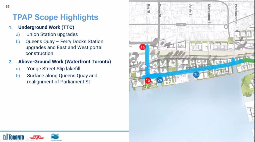
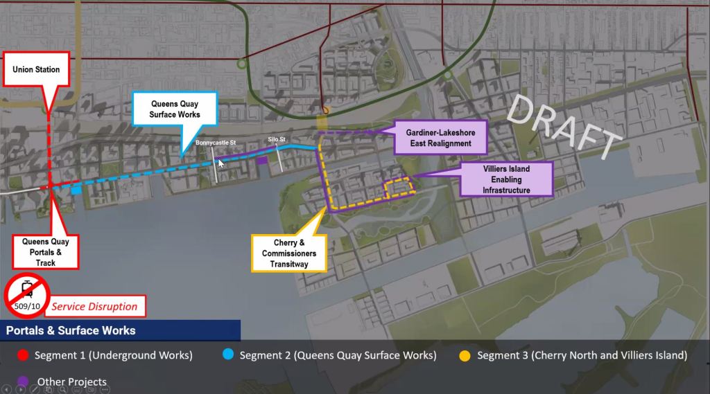
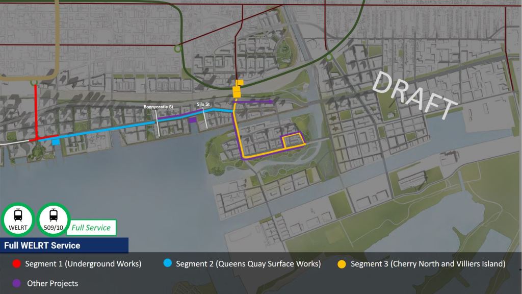
The current study is subdivided into three segments, plus future extensions into the Port Lands east of the Don River (dotted blue lines below).
- Segment 1 (red) includes the Bay Street tunnel and the portal area on Queens Quay.
- Segment 2 (turquoise) runs from Bay Street to New Cherry Street (which will open later this year).
- Segment three includes the link via Cherry from the Distillery District south to Commissioners Street and east to an around-the-block loop just west of the realigned river (yellow).

Segment 1 Videos
There are three overview videos about the project’s Bay Street Segment 1. Only one of these was shown to the public meeting (the intro), but not the more detailed reviews of plans for and construction at Union and Queens Quay stations.
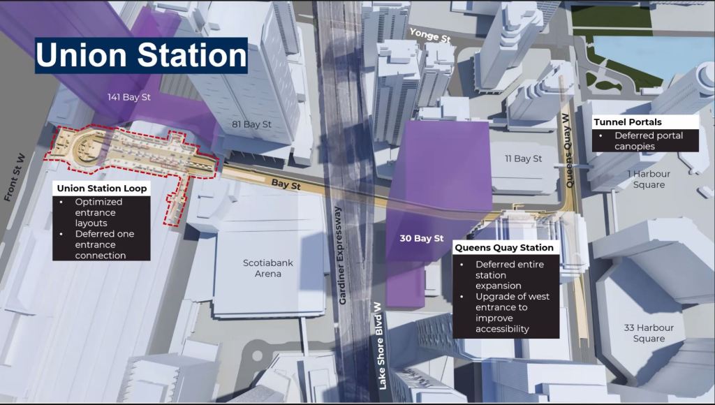
The presentation sped through a description of Union Station, but omitted construction details. It also revealed that major upgrades to Queens Quay Station are for a future project, although provision will be included in this phase of construction. This is cold comfort for many who long for an improved link to the Jack Layton Ferry Terminal. (See the section on Queens Quay and the new Portals below.)
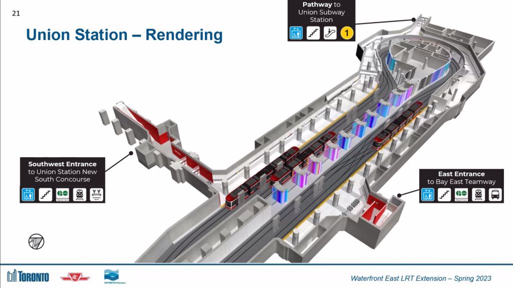
Union Station
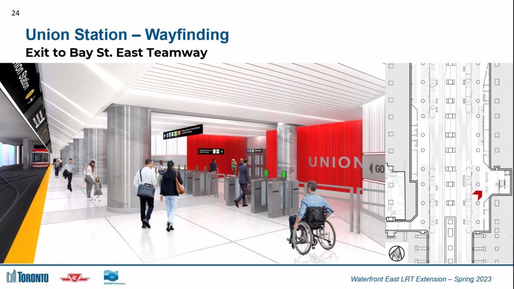
As previously reported, the design for an expanded Union Station Loop includes double platforms on both the northbound (unloading) and southbound (loading) side of the loop. Crossovers will be provided to allow cars to bypass each other at the platforms.
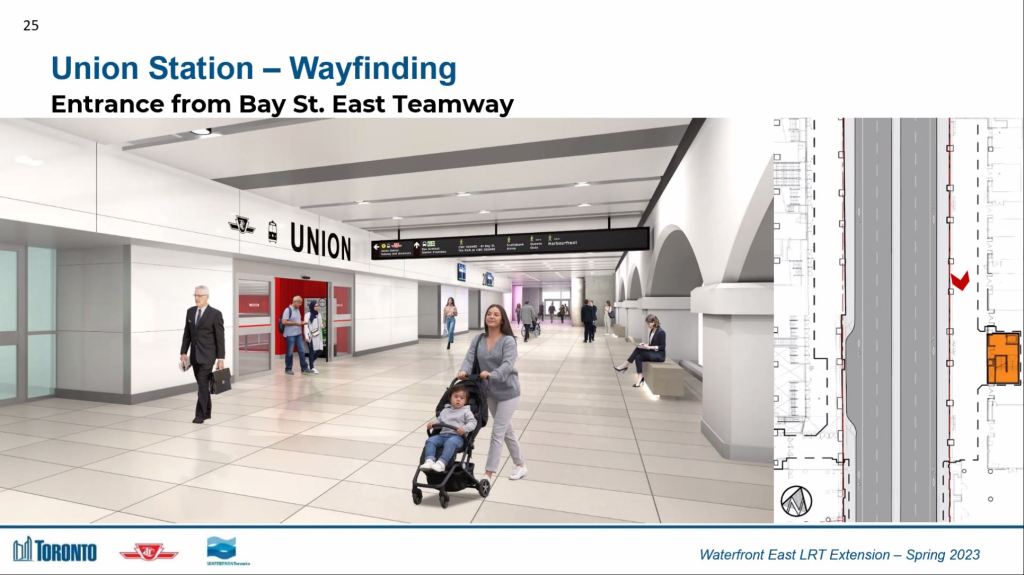
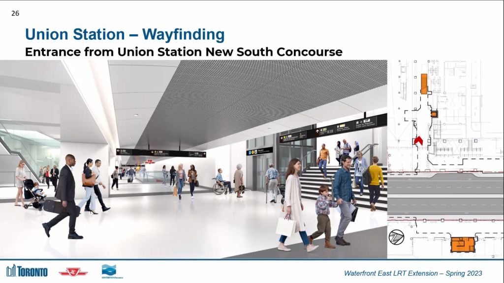
The first drawing below (click on any drawing to open the set in a gallery) shows the full Bay Street tunnel and planned works in an aerial view. The second drawing contrasts the small existing loop with the much expanded new loop including its new exits at the south end of the platforms.
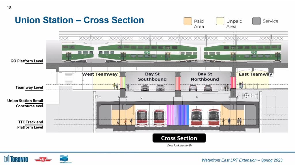
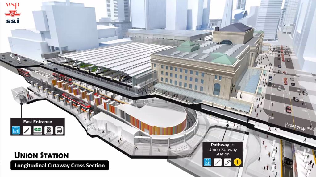
The third drawing (upper right) shows the station in profile looking north. Note the three pillars that run from the underside of the GO track slab down to the foundation of the expanded LRT tunnel. These will be built in a manner similar to the “dig down” that occurred in the main Union Station building to provide the new lower level concourse. (This is illustrated in one of the videos linked above.)
The lower three drawings show circulation patterns at street and platform levels, and a cutaway view of the full station looking northwest. The so-called “Bremner LRT” (which would branch off to the west through the basement of the Air Canada Centre) is not shown in these plans, although they do not preclude its addition later. From a planning point of view, that line is still part of Toronto’s Official Plan, even though it is extremely unlikely to be built.
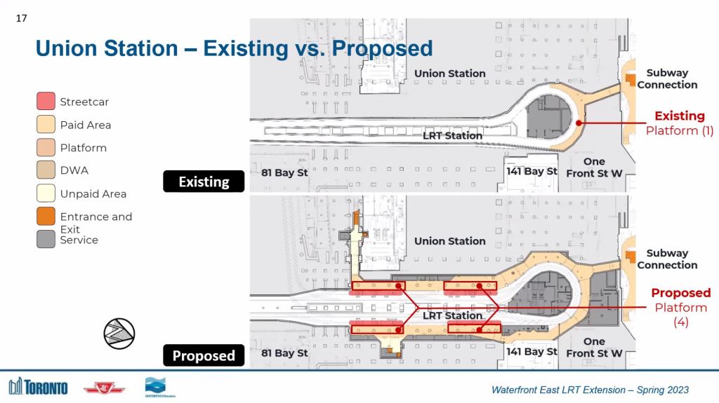
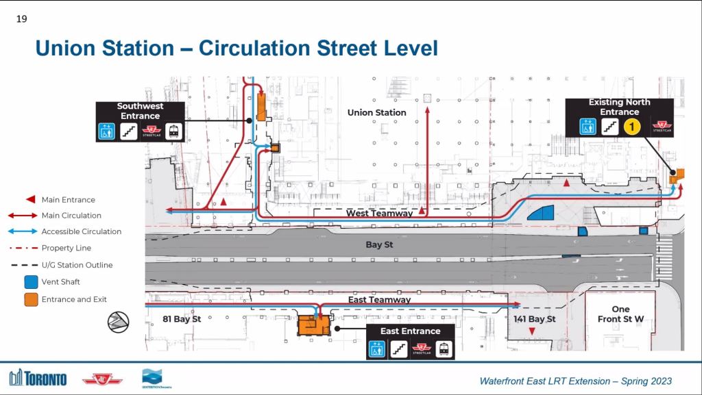
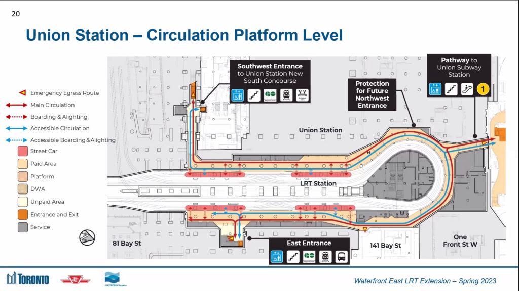
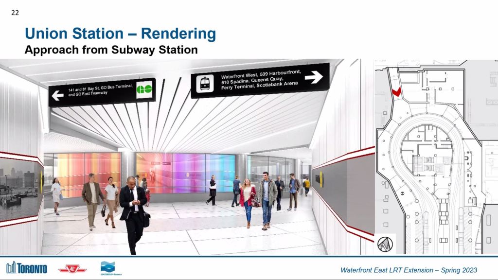
A major change in the access to and from loading areas comes from shifting them away from the curved platform at the north end of the tunnel where they are today to separate, straight sections beside the northbound and southbound tracks. With this shift, the passageway to the Line 1 subway station would no longer jam up with waiting passengers, and its capacity would be available for people moving to and from the streetcar loop.
Demand will also be spread out via the new entrances at the south end of the expanded station.
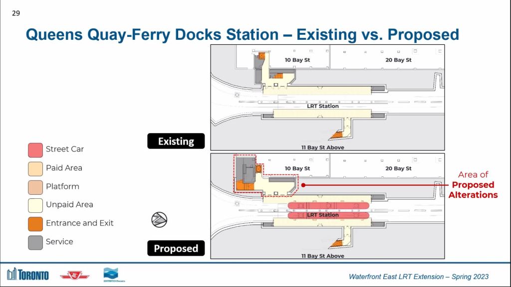
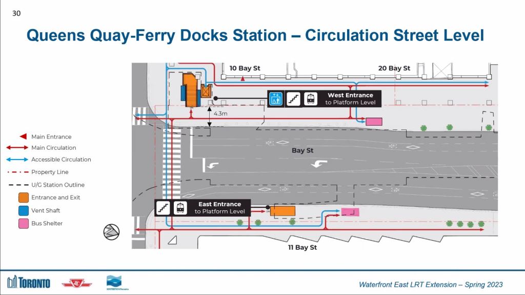
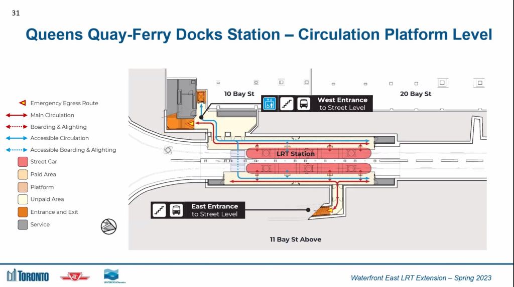
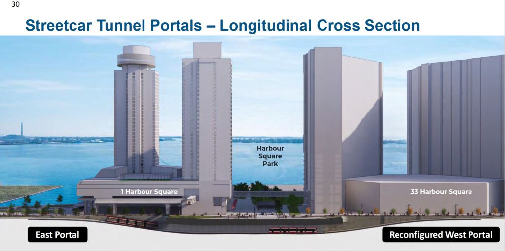
Queens Quay Station and Portals
Th online presentation skimmed over the fact that the planned expansion of Queens Quay Station has been almost completely deferred. This is partly a cost control issue, but also is related to delay in a development proposal for the northeast corner of Bay & Queen’s Quay through which a new and improved link to the station would be possible. (This site was to be a CreateTO development, but that is on hold.)
The one surviving work at this stage will be expansion and reconfiguration of the existing exit to improve the stairway and install a new elevator that will be designed both for better reliability, and for ride through flow by users of mobility devices. There will not, however, be redundant elevators here, and this is an issue that will require attention in design of the east side of the station and development at 11 Bay Street.
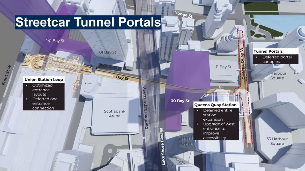
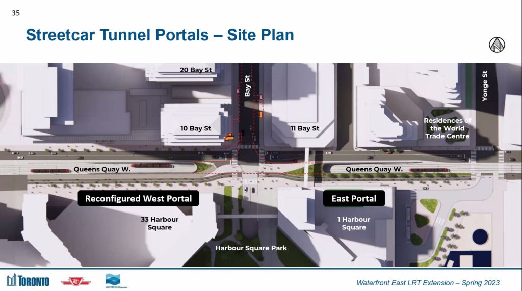
In the cutaway view (centre, below) note that the revised portal structure includes a full “T” junction so that streetcars can enter Bay Street from the west or the east, or they can operate straight through on Queens Quay.
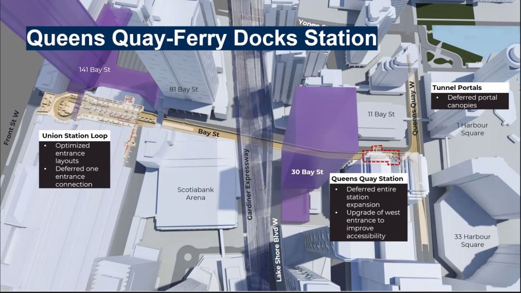
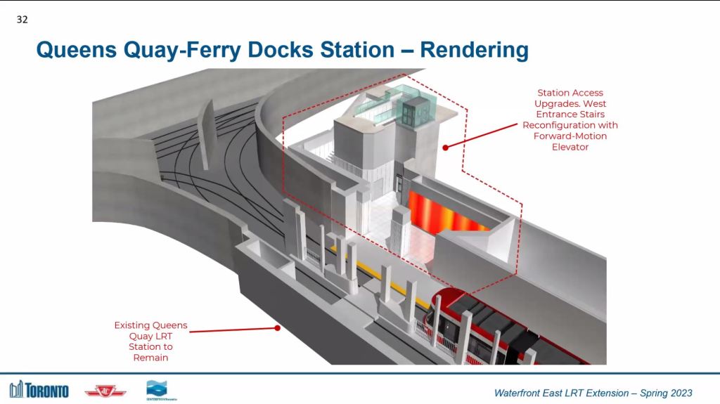

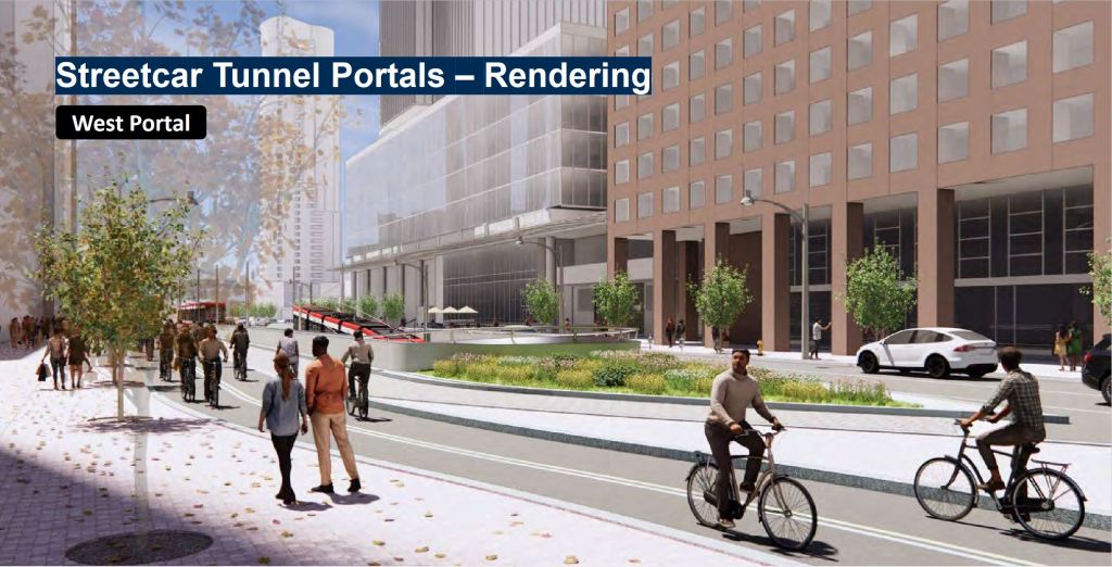
There will be two portals on Queens Quay. One is the existing west portal which will be rebuilt, and a new east portal that will lie west of Yonge Street in front of the Harbour Castle Hotel.
Decorative canopies were originally proposed for these portals, but they have been cut as a cost saving measure. The portals will be built so that the canopies can be added in the future when funding is available.

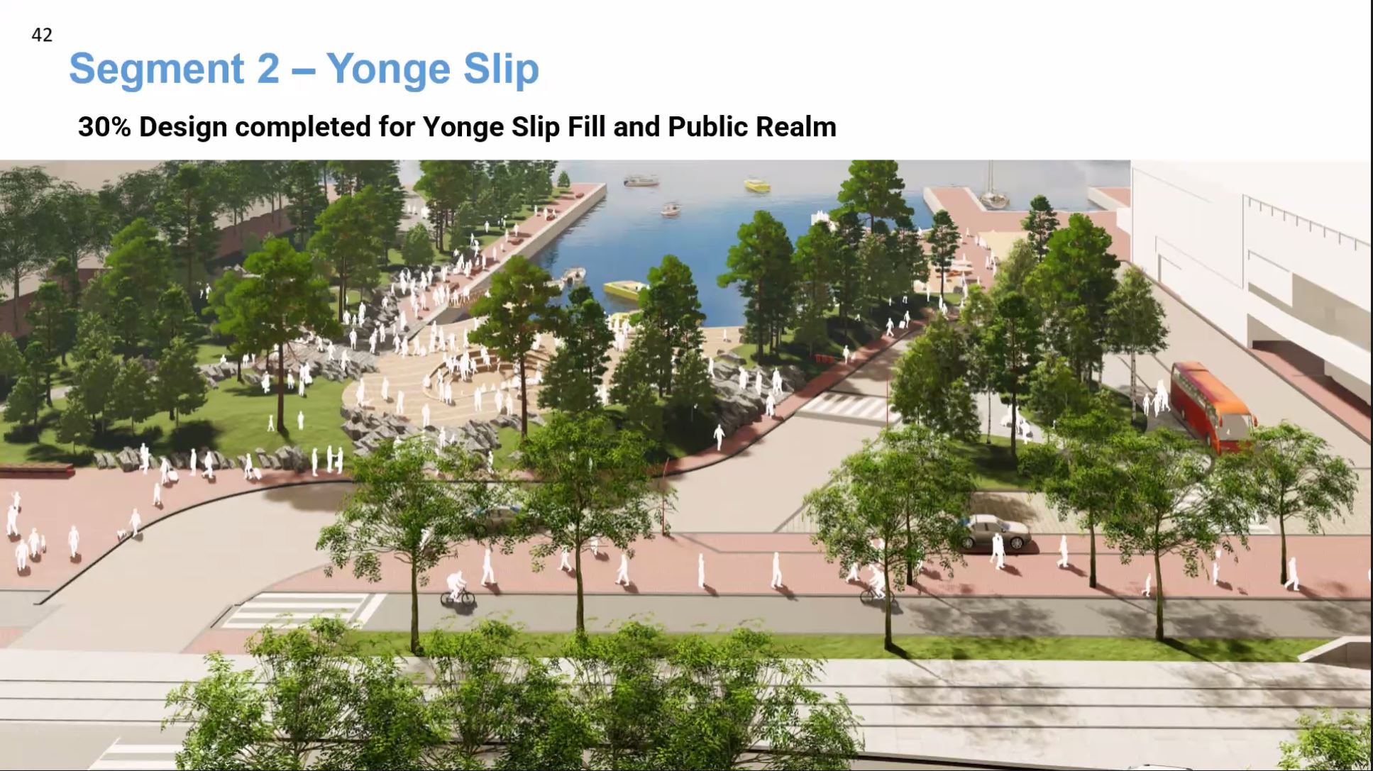
The Yonge Street Slip
The area east of the Harbour Castle Hotel at the foot of Yonge Street is now occupied by the Yonge Street Slip. The WELRT plan would partially fill this slip and create a new driveway into the hotel as well as an access to the Ferry Docks (behind the hotel).
Note that the park on the east side of the slip is not formally part of this project which would provide the land, but not the landscaping.
The Ferry Docks
Access to the Jack Layton Ferry Terminal has been a burning issue throughout this study. However, with the scope reduction at Queens Quay Station, discussion of ferry access has all but disappeared from the project.
With the planned construction in the Bay & Queens Quay intersection, an alternate route will be needed for pedestrian traffic coming south on Bay from Union Station. This will probably be diverted east to Yonge and the expanded slip shown above. However, there is also the question of transit access during various phases of construction and when the project is complete, but this has not been addressed.
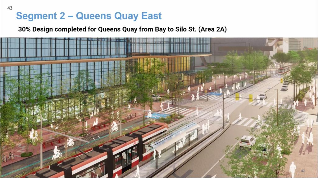
Queens Quay East Street Design
The design for Queens Quay East is descended from the original Waterfront LRT project west of Bay, but with some important changes.
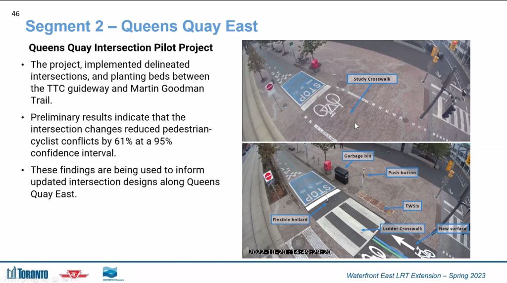
Taking advantage of the space available for much of its length, the design provides stronger delineation between the Martin Goodman Trail (cycling lanes) and the surrounding pedestrian and transit lanes. The design also includes stronger visual cues about where each “realm” begins and ends to reduce conflicts at intersections. These changes are being tested on Queens Quay West with good results, according to the project.


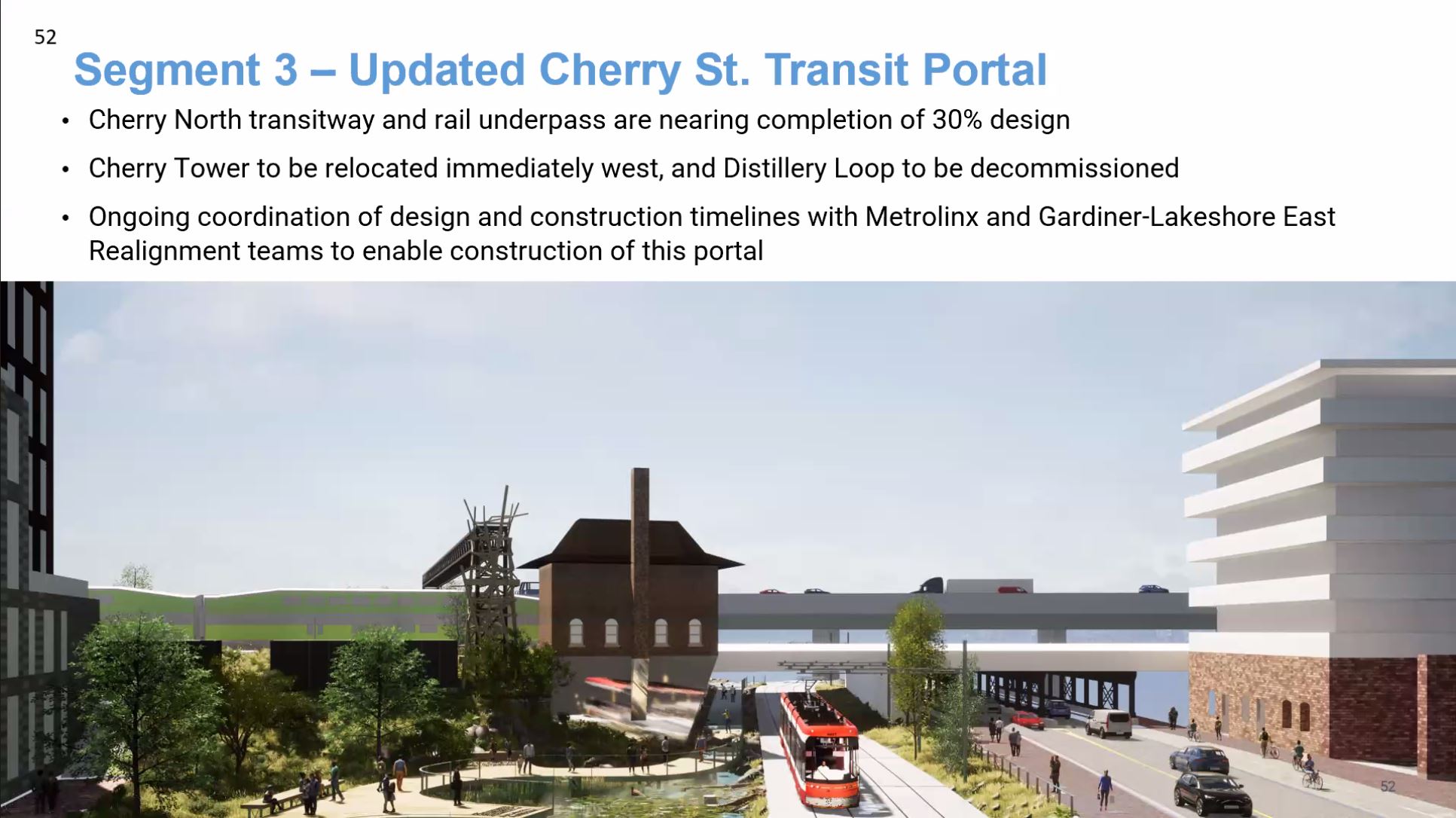
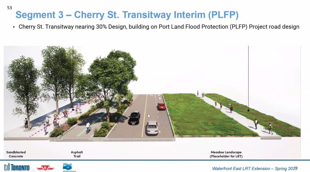
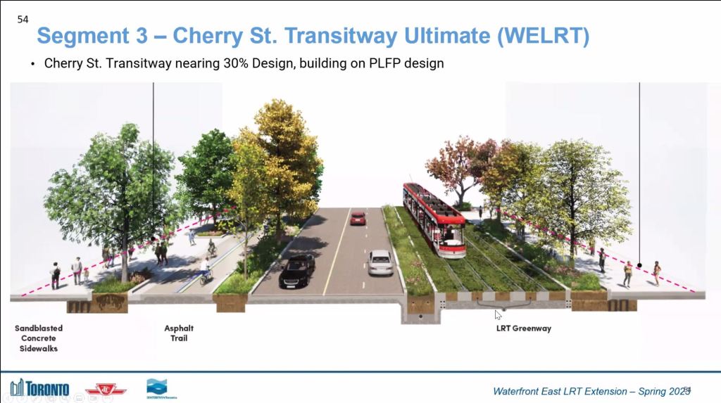
Cherry Street
The Cherry Street portion (segment 3) will connect the existing trackage at Distillery Loop with the WELRT tracks at Queens Quay and New Cherry Street. The existing loop cannot be retained because there is a grade change from the north to the south side of the rail corridor, and the new through tracks conflict with the existing loop.
As part of the work, the Cherry Tower will be shifted (it says “west” in the slide, but I think they really mean “east” here) to make room for the new underpass. In the drawing below, the new east portal holds the two LRT tracks plus a wide pedestrian connection.
The existing loop area will be partly repurposed as a small wetland.
New Cherry Street is under construction now (the portion south of Commissioners is already open), and it makes provision for a future transit corridor as shown in the left and centre views below (looking north). The Cherry North bridges already include the span for the future transit service over the Keating Channel to Queens Quay.
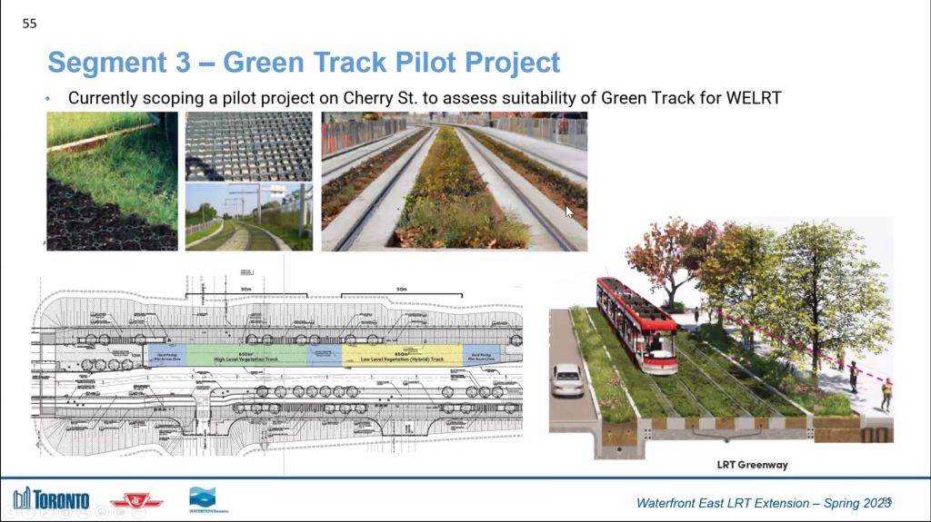
Also planned here is a test area of green track using various construction techniques. The intent is to build this before the actual LRT line as a trial particularly for use by emergency vehicles and buses. One wonders why this work is needed given the green track already built on Eglinton.
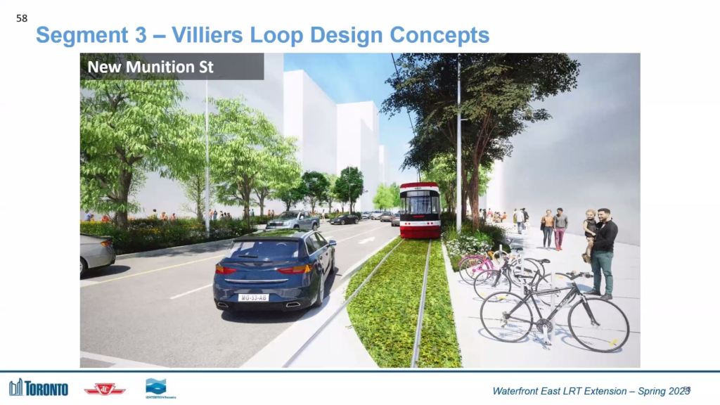
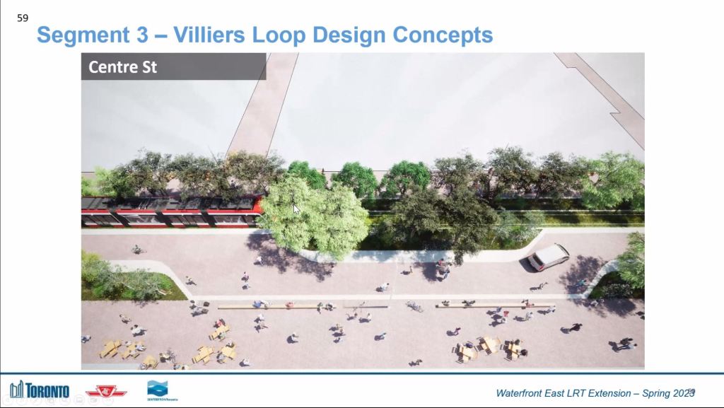
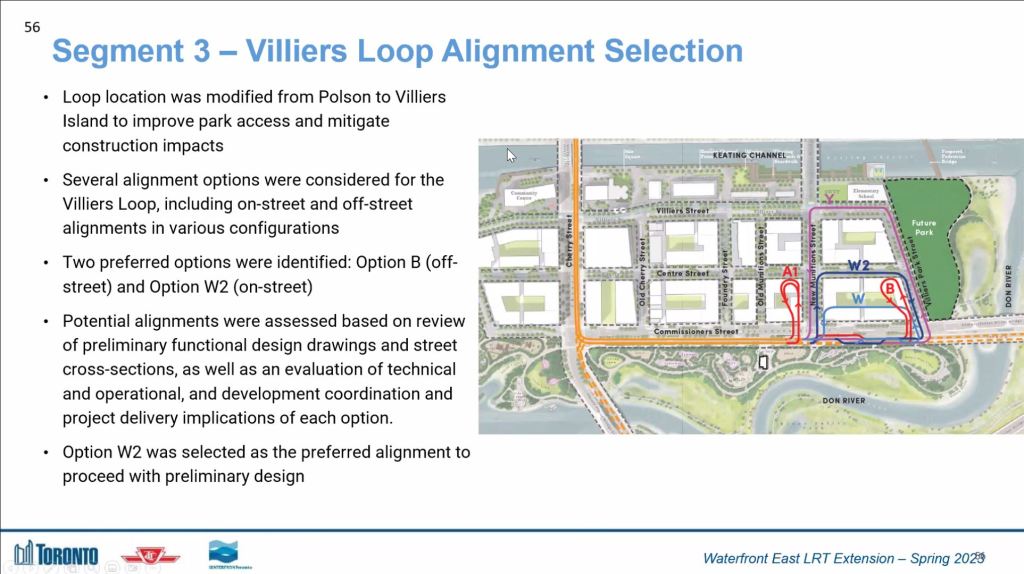
Villiers Island Loop
I reported previously on the Villiers Island Loop selection. The design uses a curb running loop via New Munitions Street, “Centre Street” (we already have one of those in Toronto), and Villiers Park Street. As and when the link east via Commissioners to Broadview and Leslie Barns is added, the existing Commissioners bridge over the new river (the orange double span for those who know the area) would be twinned for the LRT right-of-way.
Also shown in the map below is a southern extension via Cherry that would end just north of the Ship Channel in a new loop. If built, this will require twinning of the Cherry South bridge (yellow) that is already in service over the future path of the Don River. There is no intention to take the streetcar service south of the Ship Channel.

East Harbour and the Broadview Extension
Not included in this presentation was any discussion of a future extension east on Commissioners to at least Broadview and a link north to the East Harbour development and future station. Although a project to extend Broadview south from Eastern Avenue to Lake Shore is underway, the connection to Commissioners Street and the waterfront network is sitting on the back burner.
One aspect of a Commissioners track is the need to relocate the existing Hydro corridor in the middle of the street. Another is the need to twin the new Commissioner’s Street bridge over the future Don River with an LRT span.
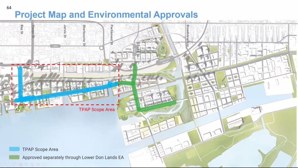
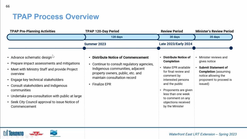
Updating the “TPAP”
A TPAP is a streamlined environmental assessment for transit projects. The existing Waterfront TPAP from 2010 is old enough that it must be updated both from its age, and to include changes to the project since it was approved. This only covers the area east to Parliament Street which was the original terminus of the scheme.
The area east of Parliament including Cherry Street and Villiers Island has a separate approval through the Lower Don Lands EA and this does not have to be revisited.

Such is one of the many cost of years of delay: studies go out of date and approvals expire. We have announced and built lots of transit, just not on the waterfront which was supposed to be a “transit first” neighbourhood.
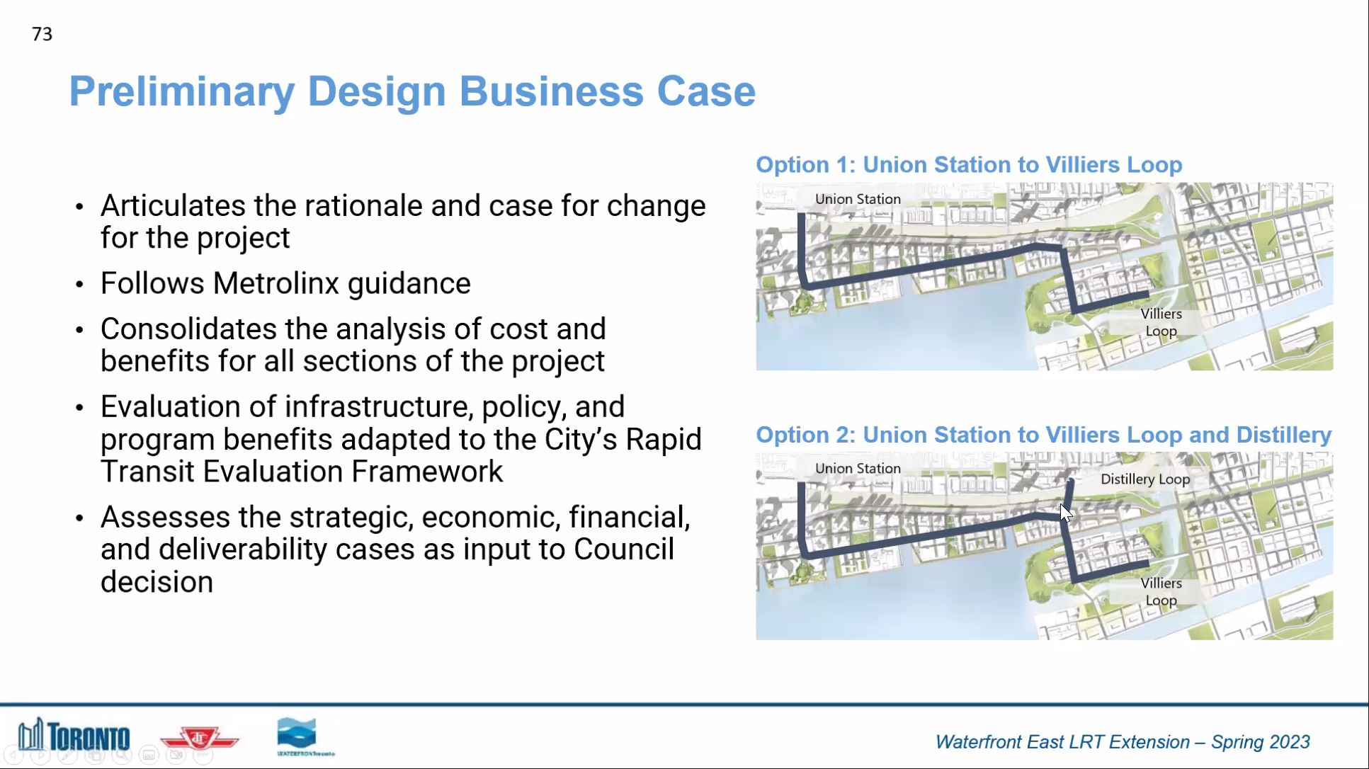
The TPAP and associated Business Case are constrained to follow the Metrolinx methodology to establish the value of options. There are really only two on the table given the area to be served.
The business case options boil down to building only the Queens Quay link, or including the Cherry Street connection to King Street. While I have a certain love for rigour and honesty in transit planning, I cannot help contrast this exercise with the “Doug Ford smote the earth” planning on a much grander scale.
With the Distillery link as an “option” and its place in the overall schedule at the end of the queue, one cannot help wondering if we will ever see it built, even though it is an important part of the overall waterfront network and is touted as a future link to Corktown Station on the Ontario Line.
Construction
Thanks to the many delays in starting this project, there is a lot of conflicting work in the area. Timelines have drifted into the 2030s before anyone will ride a streetcar onto Villiers Island.
Several works must occur first before major work could begin to establish the “new” Queens Quay, the future right-of-way on Villiers Island, and conflicts with the Metrolinx corridor at Cherry Street.
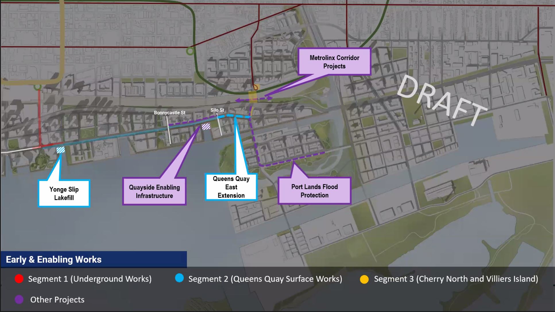
Because of many potential conflicts at Cherry Street in the medium term, building this link south to Villiers Island is not the preferred option for staging.
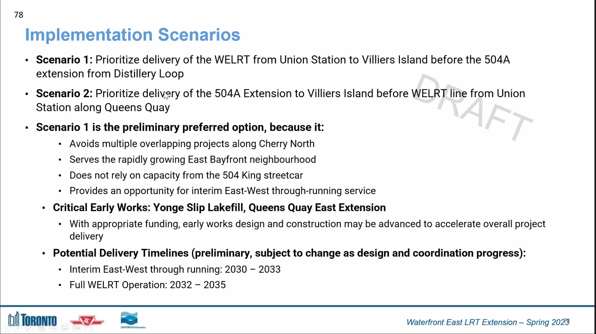
The proposed staging will see a period of possibly three years while the portal area at Bay & Queens Quay is rebuilt and expanded, following which through service from Queens Quay West to Villiers Island could begin to operate. This is an obvious target for construction design that will minimize the length of the outage.
After the reconstruction of Union and Queens Quay Stations, service to Union from both the east and west could be established. The Cherry connection would come independently of other work depending on when the link from the Distillery to Queens Quay could be built.
There is an obvious need to move up the availability of this transit project, but funding and the timing of other conflicting works will be major problems. The idea that full operation might be 12 years away in 2035 is extremely disheartening. It is a mockery of every pro-transit, pro-housing pitch from any of our so-called transit boosters.


Other Issues
Although the Constructability Review was listed on the agenda, the update was quite perfunctory saying that this work was in progress and would report out in May 2023.
During the Q&A session, the issue of waterfront traffic congestion was raised by some people. This is a major concern given the number of public and private projects in this area that will add to traffic and/or reduce road capacity. The problem is an obvious one, and it is odd that the project has not yet addressed the situation.
Access to the Ontario Line is a regular question. The project team notes that there will be streetcar service from Corktown Station via the 504A King car, as well as eventually from East Harbour Station via the Broadview extension and Commissioners Street. However, both of these are well in the future, almost certainly beyond the Ontario Line’s opening date.
A related question is how well the two Ontario Line stations will interface with surface transit in terms of transfer convenience and time.
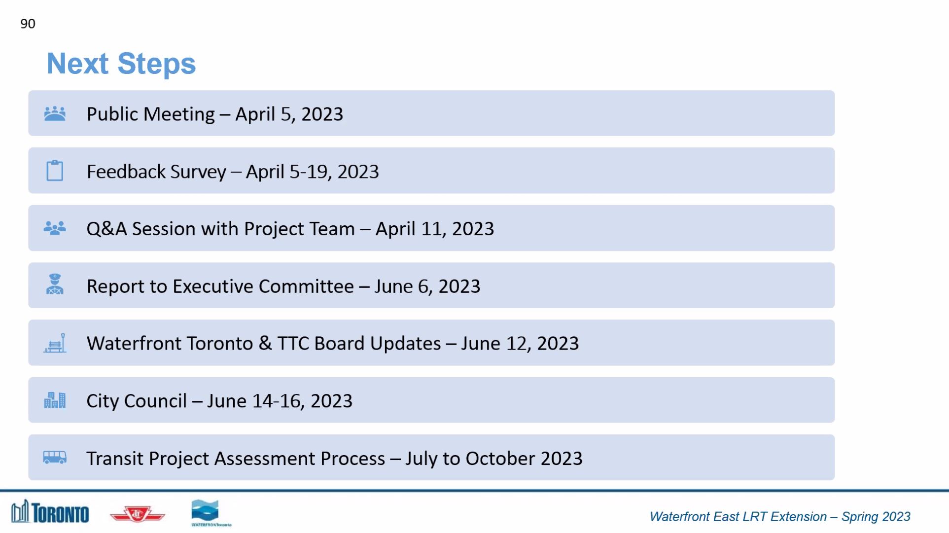
Next Steps

Is this all moot until it has support and funding from Metrolinx?
Steve: It is conceivable, albeit unlikely, that this might be a city+feds project. There is also the hope that after the 2026 election, Metrolinx might be more “pliable” presumably after serious housecleaning in the executive ranks and the Board.
FWIW there are a lot of property developers, presumably friends of Ford, who are fed up waiting for the transit line they were promised years ago.
LikeLiked by 1 person
Perhaps I’m just worn from dealing with the never-ending fiasco of bog simple projects like the KQR neverendum, and so many other Toronto and TTC snafus, but as my eyes fogged over reading this, as magnificently as Steve has presented it, none of it feels real.
Steve writes:
“2035”? How optimistic do I ‘feel’ that to be? How about most of it…’never’?
Apologies to the economics definition of “Law of Diminishing Utility”. I’m overwhelmed by the “Law of Diminishing Reality” when it comes to Toronto and transit future.
There has to be a massive reset somewhere with Toronto and Ontario politics for things to move forward.
LikeLiked by 1 person
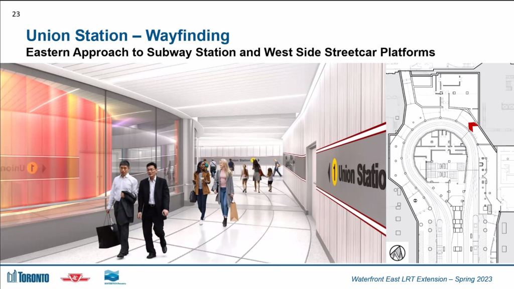
All that effort and the connection to the subway platform is still a chokepoint hallway. Could then not even try to give a little more room? Surely those storage areas could be optimized.
Steve: There are no storage areas behind those walls to optimize. Buildings and utilities are in the way. The main hope is that with the larger platforms located away from that passageway, it will not be a choke/queuing point.
LikeLiked by 2 people
On past posts I’ve asked about the originally proposed possibility of a 4-car platform along the northbound track to Union which extended into the basement of 81 Bay making for a total of 6 platforms. I recall some discussion about making money available to pay for provision of such an arrangement during construction of 81 Bay but never heard of the scheme ever again. Is this something that was quickly cancelled and no longer physically possible? Circulation with such an arrangement wouldn’t be as clean and neat as the 2+2 opposing load/unload platforms but I have my doubts about 2+2 design being enough.
I’m looking forward to the Queens Quay Station expansion in 2060 following 3 more revised TPAP’s. An extended shutdown to rebuild the station with another extended shutdown to hook up to the Distillery loop in 2080. We can’t be sparing future generations from the joys of extended shutdowns due to cost cutting and poor planning, don’t you know? There’s no better history lesson than one brought to life.
Lastly I’m going to reiterate my opinion from the previous WELRT post about the TTC massively screwing up by not moving (back) to double-ended cars. There’s no proactive thinking there because nobody there has a pulse, starting from the top down. Look at all of the pages dedicated to debating loop locations and configurations. One might think it’s a conspiracy from the TTC to keep friends at planning employed to write this material.
LikeLiked by 2 people
Since the schedule of this project is so long and the cost is likely very high given the underground work in Segment 1, I wonder if a phased approach would be better. Could the City not just build Segment 2 and the connection to Cherry to gain the streetscaping benefits and transit service on Queen’s Quay East then use the Waterfront Toronto parking lot southeast of Yonge to add a turning loop for the streetcar?
There would need to be a transfer for people going to Union, but at least you could get the majority of the alignment built earlier and the people of Queen’s Quay don’t have to live with a 4 lane industrial road for longer than needed. This would also help the busy MGT and sidewalks in the area. That parking lot is dangerous in the summer with cars always parking in the bike lane and cutting off cyclists so it would be great to see its entrance closed for good.
Steve: I agree that this would be the ideal phasing. The Cherry Street link is sandbagged by work on the Ontario Line and the Gardiner. This is what we get for all that delay.
LikeLiked by 1 person
After posting a rather negative view yesterday, I feel vindicated by others sharing much the same ‘sixth sense’ about an impending disaster, even if it is just theoretical at this time. There’s some excellent posts above.
I had a chance to do some reading to review what other options could be used in lieu of ‘reinventing the loop’ at Union. In terms of what’s being proposed, the answer could be to do very little at Union, and instead of ripping things apart (yet again), far more could be realized revisiting the East Harbour plans. I’m thinking ‘distributed load’ rather than Union on Steroids.
I’m not sure on the latest ‘theories’ as per East Harbour. Steve had an excellent examination (again) just three weeks ago.
But here’s what Metrolinx themselves state a year ago:
And here:
Steve jumps in: Remember that the myth of SmartTrack has been kept alive by Metrolinx to placate our now former mayor.
So why not just build the ‘Y’ for waterfront streetcars at Yonge and Lakeshore and alternate destinations of the trams such that riders can take the car most suited to their need at different points such that even the presently strained Union loop is suffice if the load is distributed to other nodal junctions?
Steve: Actually the wye would be at Bay & Queens Quay.
Meantime small improvements can be made at Union to improve the passenger flow to/from the trams/trains/subway w/o shutting down the whole operation for ad infinitum and costing money that not only doesn’t exist now, there’s even less chance of it being so later?
Steve writes:
That resonated as I read this in the Star:
There’s a reference in Metrolink’s own text on East Harbour being “developer led”, I apologize I can’t find it now. It’s an essential point, as once again, it seems Torontonians and the TTC are left to hoist the burden of putting money in the pockets of developers.
Steve: The scheme for East Harbour is a moving target. At first it was going to be “developer led” but they got cold feet. After Cadillac-Fairview took over the project, the plan grew a potload more residential density as opposed to the more commercial site originally imagined by Great Gulf.
Also the estimates of people working in the eastern waterfront are a bit sketchy now as I understand that plans for more commercial space there are on hold thanks to the glut of vacant office space downtown.
A lot of the work at Union is triggered by the need to dig down and provide additional air flow to meet modern fire code. Given the current level of congestion at the loop, I really cannot see just leaving it “as is”. Yes, some new demand could come in via the East Harbour hub, but that does not work well for everyone, only as an alternate.
Finally, note that the original design for an easy across-the-platform OL to GO transfer at East Harbour was abandoned a few years ago due to cost. I do agree that the Broadview extension to Commissioners and the LRT link to the WELRT should happen sooner rather than later, but the project has a strong feel of trying to get at least an initial stage funded now and this gets in the way of looking at the bigger picture.
LikeLike
Further to my prior comments, the Broadview extension has received far more intense scrutiny than I can recall (it’s partly an age thing). Steve covered it well here.
I hadn’t mentioned the Corktown Station in my ‘distributed load’ reference prior, but of course that is another transfer point, albeit not a ‘node’ per-se.
LikeLike
Many decades ago when I was a planner at the City of Toronto Planning Board, I devised a scheme for the Harbourfront streetcar that called for transit priority surface trackage on Bay Street with a street-level station on Front Street West directly over the mezzanine of the Union subway station, much like the old transferway on Bloor Street just east of Yonge. Since this was a visioning exercise, why not think outside the box. Accordingly, I envisioned double-ended vehicles and closing most of the roadway between York and Bay. This would be a very European-style tram-to-higher level transit interchange. The TTC’s fixation for underground transfer between streetcar and subway is wildly expensive and a construction nightmare. The anachronistic automobile accommodation (at seemingly all costs) is the rationale behind this current ludicrous proposal from the City. Remember that virtually everything south of Front is land-fill with horrendous problematic issues waiting to occur. The proposed new streetcar station with a four-track configuration with platforms below Bay Street is beyond irrational! All this to maintain automobile sovereignty on the chaotic streets of downtown Toronto.
The video is mind-boggling naivete, and unfortunately, symptomatic of the irrational “official” proposal from the City.
LikeLiked by 1 person
This is probably a naive comment but why can’t segment 1 be replaced with purely pedestrian access to Union, and have the new surface stations at Bay and QQ act as the major portal to a subsurface connection to Union via existing Queens Quay station.
The tunnel to Billy Bishop is about half the distance. It’s around the same distance as a worst case Spadina-Spadina connection.
Steve: This was examined as an option in a study back in 2019. There are big problems with adapting the tunnel including heating and ventillation, not to mention that it can be rather damp. The big problem is that everyone cannot walk that distance, and it should certainly not be required for access to the Ferry Docks or the waterfront generally.
As for Spadina-Spadina, that link only even exists because there was once a plan to operate the Spadina line independently and a transfer path would be required. Anyone with any sense transfers at St. George.
LikeLike
Moving the old interlocking railway tower at Cherry St. seems like a difficult and expensive proposition. Is there no feasible way to extend the LRT through the embankment without doing so?
Steve: No. In any event there have been plans for years to move the tower. Jacking it up and rolling it a short distance further east is not as complex as taking it to an entirely new site, and it will give the new LRTportal a straight run south under the railway.
LikeLike
From Transit Toronto
From July to September of the same year.
Maybe within the same century for the Waterfront East LRT and the Port Lands?
LikeLike
Why does it take five years to lay some track and grass?! If the updated TPAP is done by end 2024 and funded, we could presumably have construction start mid to late 2025. So, why would the surface portion take five years to do. The Cherry Street bridge is already there. We just have to fill in some slips, lay some track, switches, cables, concrete, and grass (for green track, please). That shouldn’t take more than a year or two, plus an extra year for redoing the portals.
The chance for the Port Lands to be transit first is disappearing, and we risk a wealthy-only neighbourhood which requires a car for going everywhere outside it.
LikeLiked by 1 person
this is of essence:
… and that there is no funding nor a champion
Otherwise everything OK… 😶
LikeLiked by 1 person
This is a great summary! Just want to point out that the official WELRT website also posted an FAQ document. Whether or not this is satisfactory they at least provided some more information there.
The rendered pictures and videos about segment 1 were awesome, but I didn’t like very much the TTC representative just mentioned the deferred plans very slightly, and even didn’t mention there were extra videos online.
Being a resident living in QQE I can only say the current bus service really sucks, not to mention the (again) upcoming planned service cut in May. I hope very much the LRT can bring a way better transit here to support the future huge demand from large number of high-rise buildings.
But at the same time traffic is still really a huge issue here, and it’ll just get worse when the roads are reduced to 2-lane. Quite disappointed to see this wasn’t even brought up during the public meeting. Hopefully there’ll be some plans proposed by any surrounding projects.
Steve: I have added a link to the FAQ at the start of the article. Yes, this does address in more detail many of the issues raised at the online session.
Re segment 1, yes, the TTC rep skated through that presentation with undue haste and in particular did not talk about the changes at Queens Quay including the potential for connections to 11 Bay or south to the Ferry Docks. Both of these have been major concerns at past meetings, and simply ignoring them gave a sense of bad faith in the presentation.
I really don’t know how the City plans to deal with traffic in the waterfront. One element that was not mentioned was the planned extension of Harbour Street east to Jarvis, nor was there any discussion of what various interim configurations will look like as construction on the WELRT and other projects in the area proceed over the next decade.
I have reached the point of despairing that we will ever see this built, and that all of this planning is just one more exercise in fantasy transit used to justify/enable massive development without actually providing the “transit” part of “transit oriented development”.
LikeLiked by 2 people
Just to harp on the topic of double-ended cars a bit more, I figure the extra trackage for the proposed on-street loop for the WELRT is approximately 350 metres of extra track. The added direct construction cost I’m sure runs into 7 figures. Add on the extra maintenance and operating costs associated with running around the block and noise added to the neighbourhood (and costs of bureaucrats to write reports on the laundry list of looping options). It’s all money which could be saved if they had the capability to reverse using the single crossover they are already planning on building next to the platform.
LikeLiked by 1 person