
The City of Toronto is completing an Environmental Assessment for the extension of Broadview Avenue south to Commissioners Street. Upcoming events:
- June 20, 2022 6:30 to 8:30 pm: In person open house at the Jimmie Simpson Centre, 870 Queen Street East
- June 21, 2022 6:30 to 8:30 pm: Online open house (the link to join is on the Public Consultation page)
- July 7, 2022: Report to the Infrastructure & Environment Committee
- July 19, 2022: Council
The project website contains assorted information including a presentation deck. This article is an abridged version of that presentation plus my own comments.
Context for the Extension
The lands east of the Don River, south of Eastern Avenue and north of Lake Shore Boulevard were for many years the site of a Lever Bros. factory, now known as the Unilever site. Massive redevelopment of this property was proposed first by Great Gulf, and more recently by Cadillac Fairview who now own it. Right in the middle of the site is the future East Harbour Station of the Ontario Line and GO Transit.
The Broadview extension will run under East Harbour Station, and an extended streetcar network will be part of the transit hub there.
This map includes some items that do not yet exist, and some that are unlikely to be built.
- Broadview south from Queen to Eastern (yellow) would be rebuilt with streetcar tracks in mixed traffic just as on Broadview north of Queen.
- The intersection of Broadview & Eastern will be reconfigured to provide a transition to reserved streetcar lanes, and to improve pedestrian safety.
- Broadview south from Eastern to Lake Shore would be rebuilt to include a transit right-of-way. It is not clear that this is a logical stopping point for construction without continuing south to Commissioners.
- The map shows Broadview extending south across the Ship Channel to Unwin including a loop for streecars beside the Hearn Generating Station. This would require a new bridge over the channel that could provide clearance for large ships as the existing bridge at Cherry does today.
- The map also shows track on Commissioners from Cherry to Leslie, but it is not clear how soon the link east of Broadview would actually be built.
- Cherry Street trackage would be extended south meeting up with the Waterfront East line at Queens Quay and continuing south to the Port Lands. The map shows a loop at the Ship Channel, but it is possible that the terminus will actually be north of the new river channel on Villiers Island.
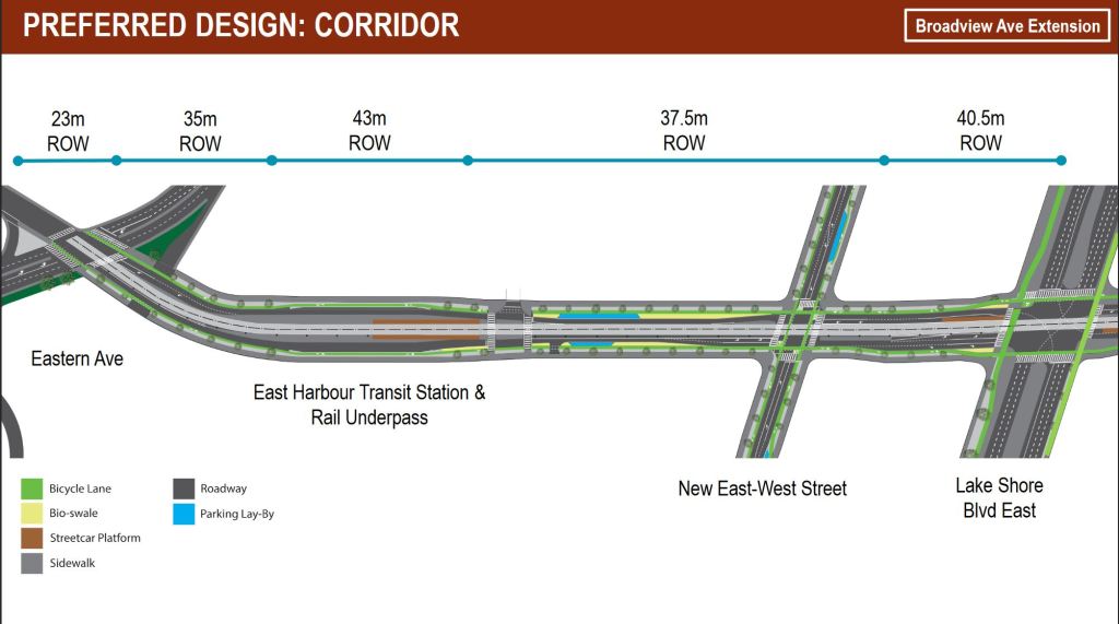
Design options for each segment of the extension are shown below.
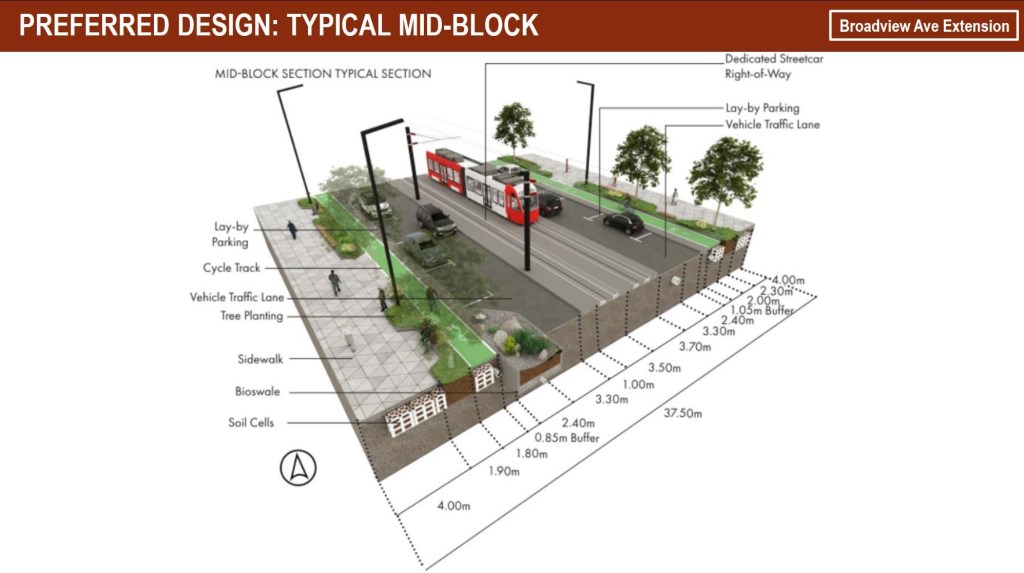
From Eastern to Lake Shore
Broadview south of Queen is a typical street in the old city and streetcars would operate there as they do on existing routes to the north. South of Eastern, the road is wider with room for more features.

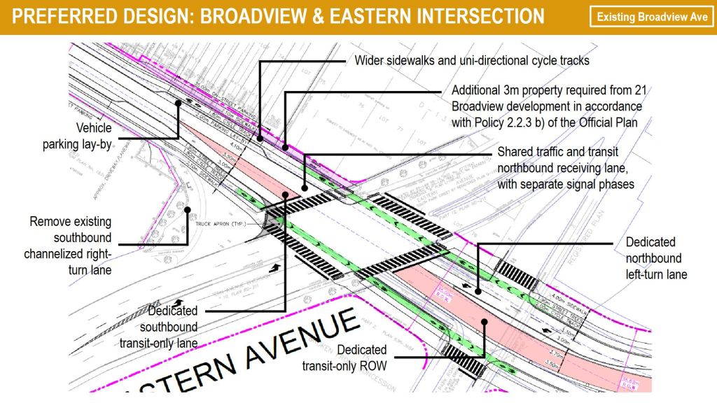
Broadview & Eastern
Various options were considered for this intersection taking into account this would be the transition from mixed traffic running to reserved streetcar lanes. The preferred version has the southbound reserved lane beginning north of Eastern as shown in pink on the map below.
The existing slip lane from Broadview to Eastern westbound would be removed.
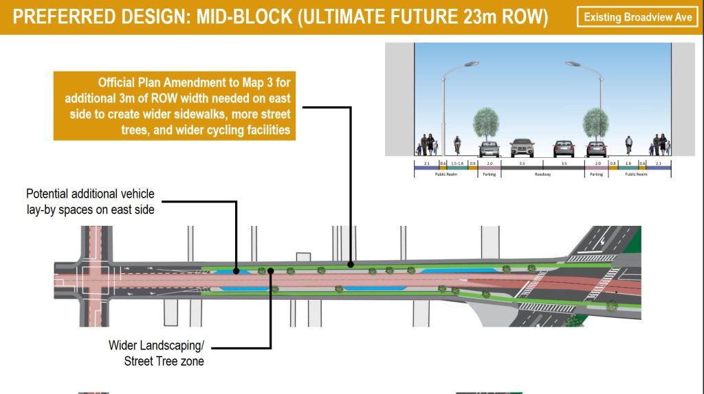
Two versions of the street are shown, one with the existing 20m right-of-way, and one with a 23m ROW that will be available when the city acquires some land on the northeast corner of the intersection as par of a future development.


DVP Ramp from Eastern
Eastern Avenue eastbound now connects to the DVP via a circular ramp. This would be changed to a standard intersection that would allow access from both directions on Eastern to the slightly-modified ramp.


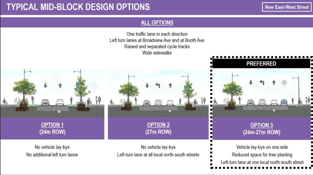
New Street
The design of a new east-west street through the Unilever site is shown here. It is a local road and has no provision for transit.


Survey
The Public Consultation page for this project includes a link to a survey.

I misspelling I saw.
Cahanged.
Steve: Fixed. Thanks!
LikeLike
Actually planning a new streetcar line (Broadview South)! Seeing will be believing, but could be nice. What new transit traffic will be there? New residences? New employment?
Cheers, Andy
Steve: Massive residential and employment development planned for East Harbour / Unilever site.
LikeLike
The new street seems like a bad idea. It turns on to what is essentially the northbound on ramp from Lakeshore to the DVP right where vehicles are accelerating to highway speeds.
Am I missing something?
Steve: That’s the Don Roadway which also will have a role as access to the southwest part of the East Harbour development, not just as an on ramp.
LikeLike
Still shows Toronto Transportation aversion to green streetcar right-of-ways.
If instead of narrow single direction cycling tracks, they combine them into wider dual direction cycling tracks, emergency vehicles could use the cycling track to get past the traffic congestion caused by single-occupant motor vehicles. Think of protected cycleways as priority lanes for ambulances.
Steve: Note that the design depends on there being some place for the cyclists to disperse to. I am not convinced this would work in some areas where we have bike lanes, heavy traffic and lots of emergency runs as on the Prince Edward viaduct.
LikeLike
What is south of the ship channel to warrant an expensive bridge just to get to Unwin Ave? Is Hearn a big source of potential TTC traffic? Are the ship channel and turning basin still in use? For what industry? It seems Toronto Harbour and Ashbridges Bay is a skeleton compared to what it was decades ago.
Steve: Yes the ship channel is very much still in use. There is a concrete plant at the east end of the channel.
As for a bridge at Broadview, its purpose would be to connect to the Hearn site assuming that might become some sort of entertainment venue. I am not holding my breath.
LikeLike
Over one hundred years later and streetcars return to the port lands. “Everything old is new again”.
LikeLiked by 1 person
The reference to streetcars returning to the Portlands puzzled me. You might want to add a link to the 1921 track map on the Transit Toronto site Of course, I still wonder WHY there were streetcars there – a barn or yard??
Steve: Service to employment in the port. It didn’t last long.
The Ashbridge route began on November 5, 1917 under the TRC running from Queen and East Don Roadway south to Commissioners, and then west to Cherry using double-ended cars. The TTC took over the route, but streetcar service ended on Sept 19, 1923 when the wooden trestle over the railway was deemed unsafe. Replaced by a bus from King & Sumach. (Source: Louis H. Pursley’s histories of the TRC and TTC.)
LikeLiked by 1 person
Hi Steve.
As the deck is not in an acceptable format (no alt text for pictures) & has really been difficult to read with any deep understanding, I’ve got a few questions.
1. Is there any deep dive on Accessibility features yet of the mass design?
Steve: No.
2. Are there any details yet of integrated, protected bike lanes, (because, yes power wheelchair users do use them!)
Steve: The drawings show bike lanes raised above the roadway and separated from both the road and the sidewalk in most cases. There is no physical barrier. In all cases, the bike lanes are unidirectional.
3. I’m concerned about the seemingly endless lack of deeply affordable, wheelchair accessible housing, this project seems to be yet another residential community, only for the rich & investors & Airbnb’s.
Steve: The original plan for East Harbour was almost exclusively for office space, but with the changing market the development is now substantially residential. Within that. how much will actually be affordable remains to be seen.
4. Connections with existing trails, as there are a few major ones in the area.
Steve: Waterfront Toronto has included bike paths on all of its street designs for this area. I do not know the sequence of what will be built and when beyond existing lanes.
5. Thanks again Steve, for your deep insights into this sort of stuff, I get so tired of the rage fits ppl seem to do on the UrbanToronto site.
E
Steve: You’re welcome. I tend to stay off of Urban Toronto because there are too many who pontificate without doing basic research, and who think that I am personally responsible for every transit problem of the last fifty years. I am far too modest to claim such powers. It has only been 49 and a half years.
As for the deck, I am surprised that the City has published it without accessibility tags.
LikeLike
Is Broadview under the East Harbour station (third picture in “From Eastern to Lake Shore” section) planned with transfers between streetcars and OL/GO only via roadway crossing? Or are stairs/elevators down to streetcar platforms be too early/out of scope for this design?
Steve: I have not yet seen a drawing showing how the station as a whole will work. Transfers between GO and the OL will use a mezzanine level under the tracks, but I do not know what the arrangements will be to access this from the streetcars.
LikeLike
Broadview needs to be widened, not extended. The DVP could use some widening too with bus only lanes and bike lanes which the widening would allow to be installed.
Steve: Are you at all familiar with either Broadview or the DVP in that area? There is no room to widen either of them.
As for the extension, it is meant to be the main north-south road through a new development.
LikeLiked by 1 person
Queen Broadview could use another touch up. Portions of the intersection are falling apart already less than 8 years after reconstruction. I would not be surprised to see a slow order return in the near future.
Steve: Yes. I was there yesterday and noticed several places that need work. What is particularly striking is the joints that were not welded between the special work and the adjacent tangent track.
LikeLike