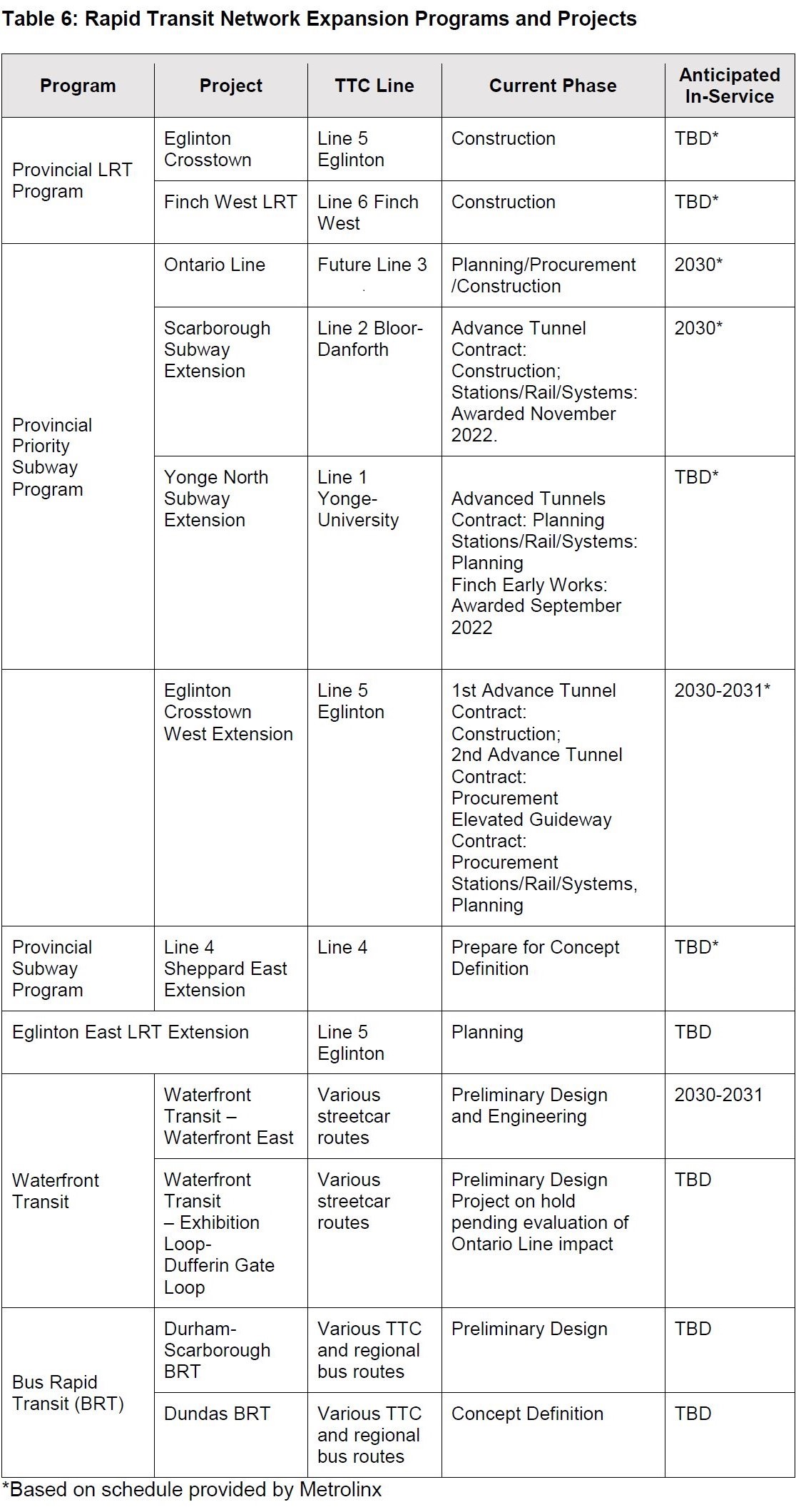
At its meeting on February 28, the TTC Board will receive a report summarizing the status of most of the rapid transit plans in Toronto. This article condenses the TTC report and reorders some sections to group related items together.
Dominant among many projects are, of course, the “big four” provincial projects: Ontario Line, Scarborough Subway, Yonge North Subway, and Eglinton West LRT extension.
Project Status Overview
The effect of major projects elbowing everything else aside is clear in the table below. Some projects do not have in service dates because they are not funded, and the timing of that (when and if it occurs) will determine when various lines can open.
Not shown in this table are several major projects that pop up from time to time:
Bloor-Yonge Station Expansion
Waterfront West LRT from Dufferin to The Queensway
Bloor West subway extension
New Line 2 fleet and yard at Kipling (Obico yard property)
Sheppard East subway extension
Platform Edge Doors
Of these, only the Bloor-Yonge project has funding, and some are only a glimmer in various politicians’ eyes.
Prologue: When I started to write this story, John Tory was still Mayor of Toronto and the dynamics of City-Province relations assumed he was in charge. The context for these discussions was soon to change.
The Toronto Region Board of Trade holds a yearly “transportation summit”, and on February 8, 2023, this focused on the Greater Toronto Area’s transit, plans for the future, and the aftermath of the covid pandemic.
The TRBoT is no wild-eyed radical institution. The regional economy and businesses are at the heart of causes it advocates.
Both in the introductory remarks and in comments by speakers sprinkled through the day, the economic effect of traffic congestion was a mantra. This sets the framework for the importance of both transit and road projects, depending on who is speaking. The latest factoid describing Toronto’s problems is that we have the third worst congestion in North America and the seventh worst in the world.
A problem with this hand-wringing is that there is little acknowledgement that some particularly bad locations are related to major infrastructure projects such as the Gardiner Expressway rebuild and various rapid transit lines. Moreover, goods movement has severe problems in areas that historically have poor transit and show little chance of seeing any in the near future. No single project will solve the problem of many-to-many trips patterns that now depend almost totally on roads and private vehicles.
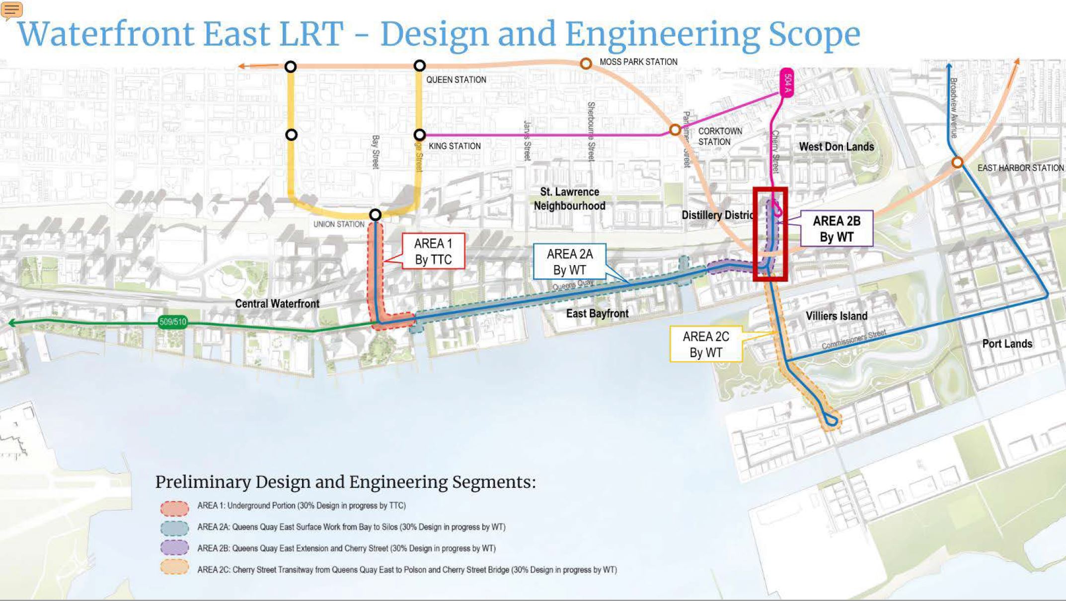
Design of the Waterfront East LRT is still underway by Waterfront Toronto and the TTC. Whether this project will be funded in the near future and built remains to be seen, but one issue is now settled, pending public feedback and formal approval.
The question has always been “where will the line end”, at least in the interim configuration before the full buildout of trackage in the Port Lands.
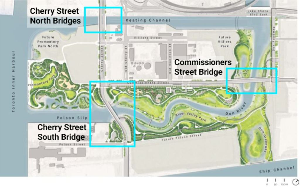
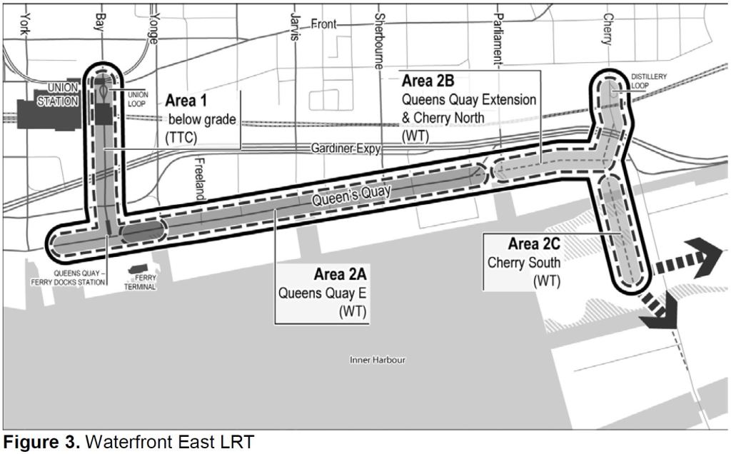
Here is an overview map of the area. Note that it shows the configuration the rerouted Don River, and the new alignments of Cherry Street and of Queens Quay.
Starting at Union Station, the segment in red south and east along Queens Quay to the portal west of Yonge is a TTC design task that is now underway.
The blue segment along Queens Quay east to Cherry is a Waterfront Toronto design project. Note that it crosses a partly filled Parliament Slip (purple) rather than dodging north to Lake Shore Boulevard as Queens Quay does today.
The yellow segment is on New Cherry Street and Commissioners Street. It will include an extension of the streetcar network south from Distillery Loop and east via Commissioners Street. For those who are familiar with the area, New Cherry and the transit right-of-way will cross the Keating Channel on two new bridges (the red ones for those who know them).
Various extensions (dotted black lines) are proposed:
South via Cherry to Polson Street. This will take the line over the new Don River and will require twinning the existing yellow bridge where New Cherry makes the transition into Old Cherry as it crosses the new Don River.
East via Commissioners to Leslie Barns making a second connection to this major TTC site and a possible service through the eastern Port Lands. This will require twinning the double-span orange bridge which will carry Commissioners Street over the new Don River.
North via an extended Broadview Avenue to connect with GO and the Ontario Line at East Harbour Station and thence north to Queen Street.
Out of sight of most in Toronto, the mouth of the Don River has been transformed by Waterfront Toronto with earth moving and landscaping on a scale rarely seen in these parts. The work will shift the Don River’s course and provide floodproofing for a large area to be developed under the name “Villiers Island” after a street in the northern edge of the district.
Cherry Street will shift to the west the equivalent of a short city block, and the New Cherry will eventually have a branch of the Waterfront East streetcar service if the City ever gets around to financing and building it.
Three new bridges were built in Nova Scotia by Cherubini Metal Works. Waterfront Toronto has an article about the design process and, of course, many articles and photos of the overall project. The map below shows the positioning of the three bridges.
The bridges share a common design, but each is unique in its own way.
The Cherry Street North bridges, one for road traffic and one for transit, will connect the New Cherry Street across the Keating Channel to a reconfigured Cherry and Queens Quay intersection. Eventually, there will be streetcars on a realigned Queens Quay East as well as south from Distillery Loop connecting to New Cherry. These bridges are red.
The Cherry Street South Bridge is a road bridge over the future river connecting New Cherry to the existing road at Polson Street. This bridge is yellow. Depending on the route taken by the new streetcar service, there could be a loop somewhere north of the Ship Channel. If so, the Cherry South bridge will gain a transit twin like the north bridge.
The Commissioners Street bridge carries Commissioners Street over the future path of the river. Because of its length, it is a double span. This bridge is orange. Like the Cherry South bridge, it could gain a twin set of spans for transit if trackage is ever extended east from New Cherry either to an extended Broadview Avenue or further east to Leslie Barns at Commissioners & Leslie.
The new river is not yet flooded and so there is water in the old Polson Slip west of the Cherry South Bridge, but the riverbed east and north of there is completely dry as work to prepare it continues.
The TTC Board held its last scheduled meeting of the current term on July 14. Barring an emergency requiring a special meeting, the next regular meeting will follow reconstitution of the Board after the municipal election in the Fall.
Some items on the agenda have already been covered in previous articles:
The CEO’s Report contains many charts purporting to show the operation of the system. Unfortunately some of these hide as much as they tell by giving a simplistic view of the system.
I have already written about the wide discrepancy between actual short turning of vehicles and the reported number. A distortion this major calls into question the accuracy and honesty of other metrics in the report.
In a future article, I will turn to the appropriateness of various metrics, but here are some key areas:
Averages do not represent conditions riders experience. Data that are consolidated across hours, days, locations and routes hide the prevalence of disruptions. Service that is fairly good on average can be terrible for riders who try to use it at the wrong time.
Values for some metrics are reported with capped charts that show only that a target is met, but not by how much it was exceeded. This gives no indication of the room to improve the target value, nor of the variation that could make a higher target difficult to achieve consistently.
Reliability is shown only for vehicles that actually operate in service, but there is no measure of actual fleet utilization and the headroom for service growth using available buses, streetcars and subway trains.
In discussion of the report, Commissioner Carroll noted that the TTC still has a problem with on time performance for streetcars. CEO Rick Leary replied that there is an On Time Performance team who are looking at details including recognition that there are three types of routes: those that run well, those affected by construction and those with other problems.
Carroll replied that people are quick to complain about King Street and wondering why they are still waiting for the 504. The TTC says that construction is the reason, but do they have a strategy to deal with bunching and communicate with riders. Management replied that they have strategies for keeping riders informed during planned diversions, but for unplanned emergencies there are service alerts. Changes are coming and service should improve.
This discussion was frustrating to hear because, first off, the central part of 504 King between Dufferin and Parliament is not affected by construction. Only the outer ends in Parkdale/Roncesvalles and on Broadview have (or had until recently) bus shuttles. As for keeping riders informed, irregular service plagues all routes in the system as I have documented in articles here many times. The problem is line management, or the absence of it.
On another topic, Carroll noted that the TTC seems to have a lower standard for the condition of stations than it does for vehicles, or at least tracks the latter at more detail. Leary replied that a summer blitz using student workers will scrub down all stations to bring the system back to a better quality for riders returning in the Fall.
The City of Toronto is completing an Environmental Assessment for the extension of Broadview Avenue south to Commissioners Street. Upcoming events:
June 20, 2022 6:30 to 8:30 pm: In person open house at the Jimmie Simpson Centre, 870 Queen Street East
June 21, 2022 6:30 to 8:30 pm: Online open house (the link to join is on the Public Consultation page)
July 7, 2022: Report to the Infrastructure & Environment Committee
July 19, 2022: Council
The project website contains assorted information including a presentation deck. This article is an abridged version of that presentation plus my own comments.
Context for the Extension
The lands east of the Don River, south of Eastern Avenue and north of Lake Shore Boulevard were for many years the site of a Lever Bros. factory, now known as the Unilever site. Massive redevelopment of this property was proposed first by Great Gulf, and more recently by Cadillac Fairview who now own it. Right in the middle of the site is the future East Harbour Station of the Ontario Line and GO Transit.
The Broadview extension will run under East Harbour Station, and an extended streetcar network will be part of the transit hub there.
This map includes some items that do not yet exist, and some that are unlikely to be built.
Broadview south from Queen to Eastern (yellow) would be rebuilt with streetcar tracks in mixed traffic just as on Broadview north of Queen.
The intersection of Broadview & Eastern will be reconfigured to provide a transition to reserved streetcar lanes, and to improve pedestrian safety.
Broadview south from Eastern to Lake Shore would be rebuilt to include a transit right-of-way. It is not clear that this is a logical stopping point for construction without continuing south to Commissioners.
The map shows Broadview extending south across the Ship Channel to Unwin including a loop for streecars beside the Hearn Generating Station. This would require a new bridge over the channel that could provide clearance for large ships as the existing bridge at Cherry does today.
The map also shows track on Commissioners from Cherry to Leslie, but it is not clear how soon the link east of Broadview would actually be built.
Cherry Street trackage would be extended south meeting up with the Waterfront East line at Queens Quay and continuing south to the Port Lands. The map shows a loop at the Ship Channel, but it is possible that the terminus will actually be north of the new river channel on Villiers Island.
Design options for each segment of the extension are shown below.
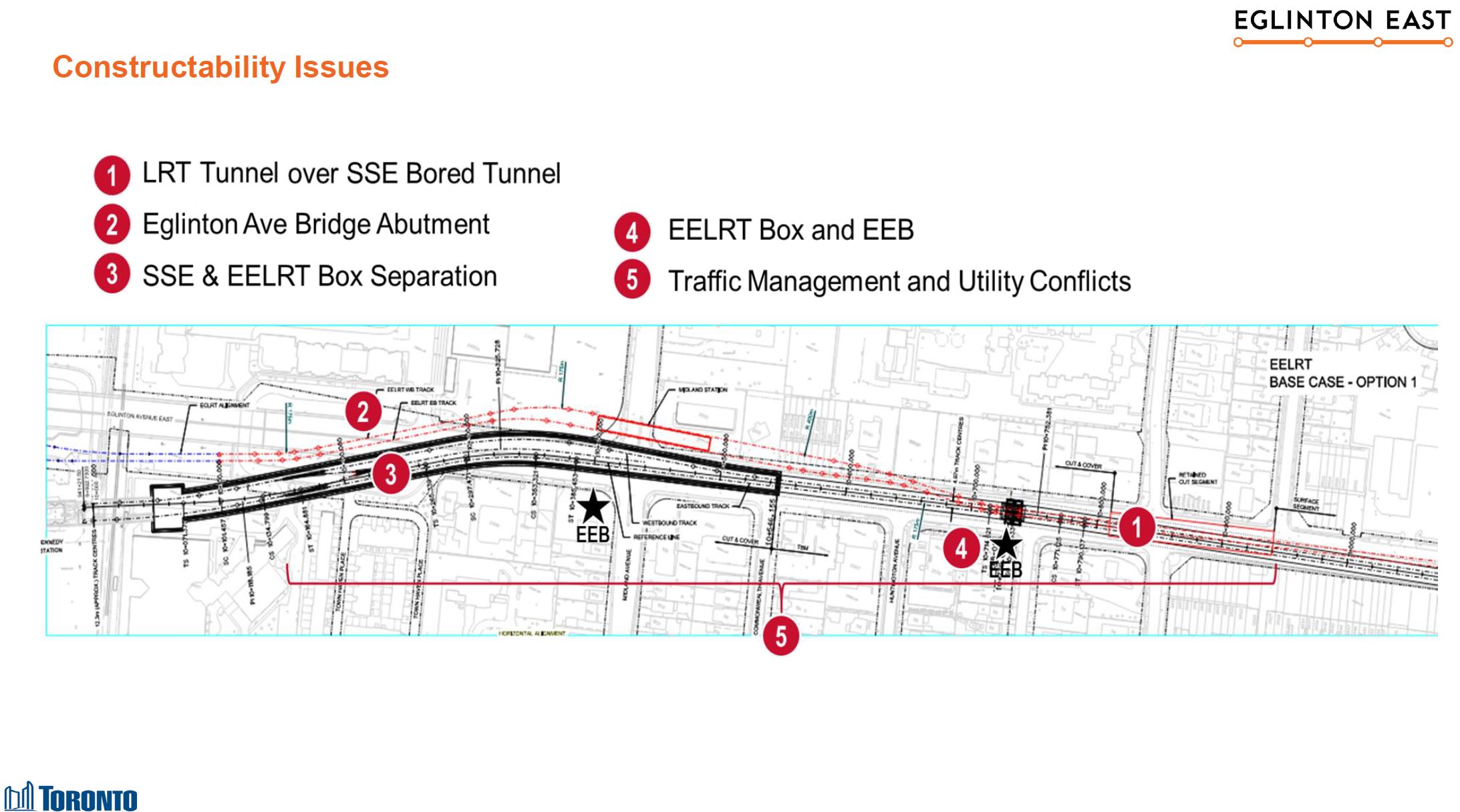
On June 15, 2022, City Council debated a report about future LRT lines in the Waterfront and on Eglinton Avenue East. As with all transit discussions transit discussions, other topics including the Sheppard West subway made an appearance. A short staff presentation added a few more details about problems at Kennedy Station that triggered changes in the Eglinton East proposal.
The Changing Configuration of the Scarborough Subway Extension and LRT
Some of the issues at Kennedy Station arise from changes made over the years in the Scarborough Subway Extension (SSE) project effecting the alignment and size of the subway tunnel. The staff presentation did not explore all of this history, but one cannot really understand what has happened without all of the details.
The City talks of Metrolinx deciding to widen the subway structure, but the story is more complicated.
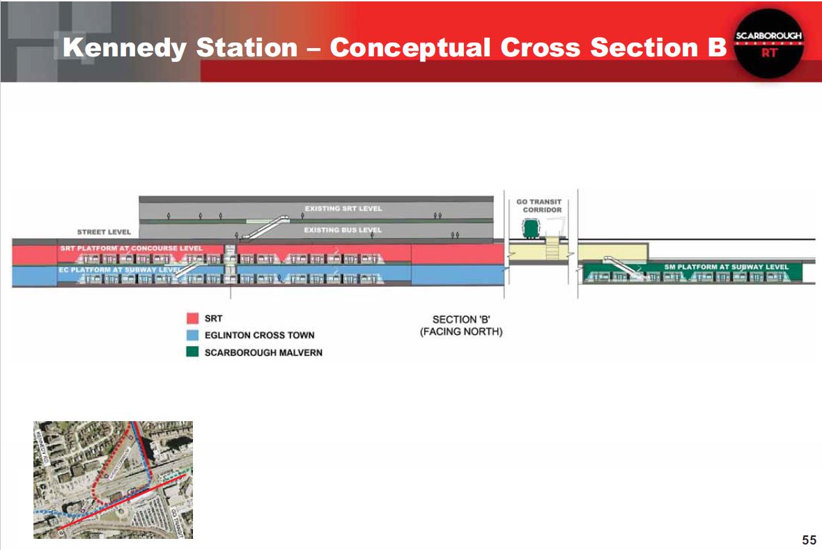
The original plan for Kennedy Station (when the Scarborough network was LRT-based under Transit City) would have seen the new LRT station immediately north of and adjacent to the subway station. It would have been a multi-level station given the number of lines it would serve.
The bottom level, at the same elevation as the subway platform, would have served the Crosstown (Line 5). This would have provision for eastward extension under the GO corridor and then surfacing in Eglinton Avenue as the Scarborough-Malvern LRT line (now known as the Eglinton East LRT, or EELRT).
The upper level, at the same elevation as the mezzanine of the subway station and one below the surface bus loop, would have served the LRT replacement for the SRT (SLRT). There would have been a large loop and loading platform at the north side of the mezzanine somewhat like the arrangement at Spadina Station for the 510 Spadina streetcar, but considerably larger given the passenger volumes and size of trains that would operate on the SLRT.
This configuration would give a short transfer connection to the subway via the mezzanine up one and then down one level for the Crosstown, or simply across the mezzanine from the SLRT and down one level to the subway. Connections to surface bus routes would not change.
Drawings for this design are in the following article from July 2016:
Here is a cross section showing the platforms for the SLRT and Crosstown stacked west of the GO corridor, and the SMLRT to the east. It was already in its own station and shows a two-car train rather than a three-car train for the Crosstown and SLRT.
When the City proposed the SSE, the extension included a third track east of Kennedy Station that would be used to short turn half of the peak period service similar to what was done at Glencairn Station on the Spadina leg of Line 1 in pre-pandemic service. This scheme also had the advantage that it could be operated with the existing fleet of T-1 trains on Line 2, and for time there were plans to rebuild these trains for life to 2040 to avoid a new car order.
This is an example of the budgetary machinations needed to keep TTC spending within unrealistic City targets.
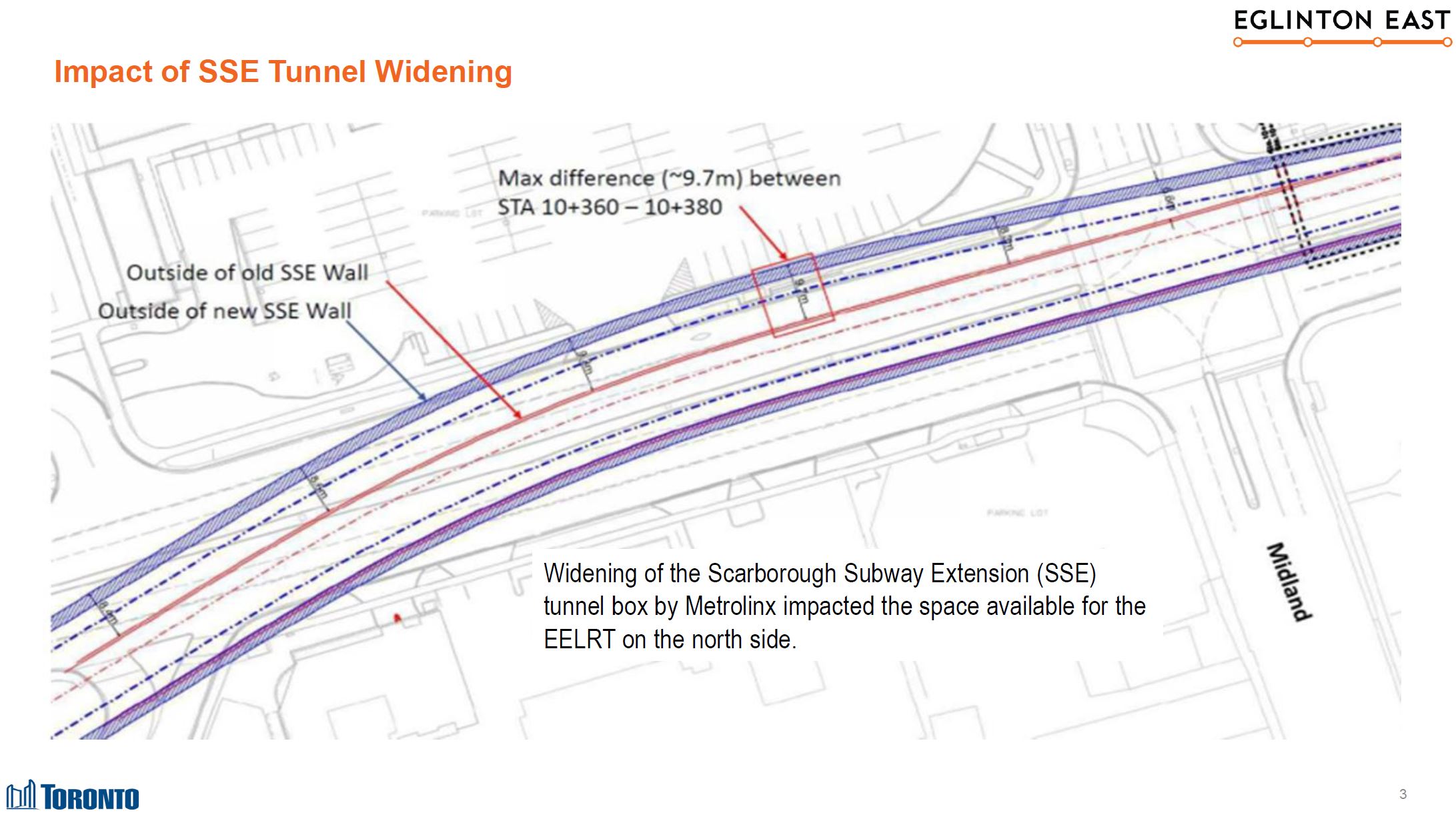
Scarborough Councillors and activists objected to getting only half of the full service, and the third track was deleted from the plan. This made the tunnel narrower, and that was the version of the project Metrolinx inherited in the provincial takeover of the SSE.
Subsequently, Metrolinx reinstated the third track causing the tunnel to widen again. (Any decision on the future service plan will affect the size of the new train order when the T-1 fleet is replaced later in the 2020s.)
Meanwhile, with the deletion of the SLRT from the plan, Metrolinx changed the elevation of the Crosstown station to be at the mezzanine level as they no longer had to provide for an SLRT interchange. The EELRT, if built as an extension of the Crosstown, would cross under the GO corridor at Mezzanine level and then rise to the surface.
However, the widened subway tunnel does not give enough room for the EELRT tunnel above it, although obviously if this had been designed as a single structure that would not have been an issue. A good example is St. George Station which houses two lines within a single structure. This shows what happens when the province designed its own projects, and the City dropped the ball on necessary integration because the EELRT was much less important politically than the SSE.
As an alternative scheme, a completely separate tunnel would be needed along the north side of Eglinton for the EELRT. This would be built cut-and-cover given how close to the surface it would have to be, and this would mean the acquisition and demolition of many properties along Eglinton.
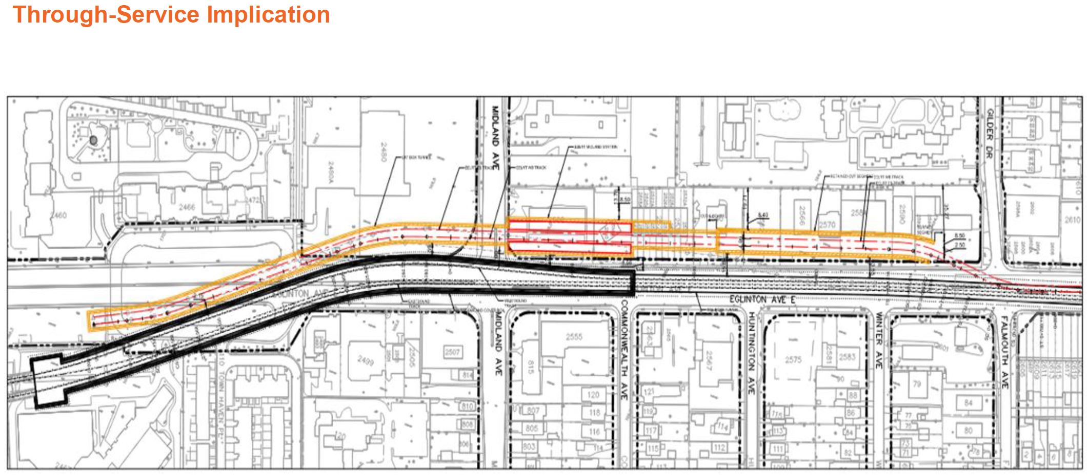
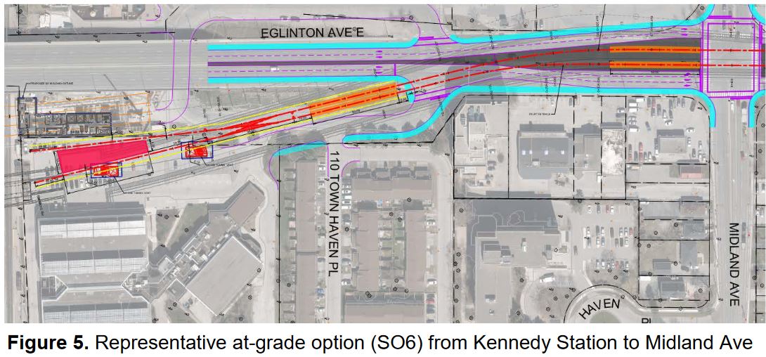
As I reported in a previous article, the EELRT station at Kennedy will now be on the surface south of Eglinton and East of the GO corridor. It will share access to the subway and the Crosstown line via the existing tunnel to the station mezzanine. No details beyond the drawing below have been provided yet.
The section of this report covering the Waterfront projects is a tad on the threadbare side compared to previous iterations such as the presentation almost a year ago. With luck there will be more detail in presentation materials at the meeting.
The report text implies that there have been design changes but does not go into details. One might hope for additional information when staff presents the report.
Cherry Street
At the eastern end, the Waterfront line is projected to end on Cherry somewhere on Villiers Island. It is not clear whether the southern terminus of the WELRT on Cherry will be north or south of the new river. Some reports and drawings talk of the line going south of Villiers Island to the ship channel, but the current report talks of a new loop within Villiers Island itself (i.e. north of the new river). Note that the map above includes an arrow showing a potential extension south over the new river as well as east on Commissioners.
Wherever the new loop is, it will replace the existing Distillery Loop which conflicts with the new alignment for the streetcar tracks and underpass at the GO corridor. The old Cherry Street signal tower, a remnant of the days when the rail corridor was operated with manual switchgear, will be shifted east from its current location south of Distillery Loop to accommodate the new tracks.
For those unfamiliar with the area, Cherry Street will have three water crossings. From north to south on the map above:
At the Keating Channel, a pair of new bridges (one for road traffic, one for LRT) are located west of the existing Cherry Street crossing. The LRT bridge is in place, and the road bridge immediately to the west will soon follow.
The new outlet of the Don River is under construction, but still dry. If the WELRT goes south to the ship channel, there will have to be an LRT span here just as at the Keating Channel. The road bridge is in place waiting for New Cherry Street to be completed to connect with it.
At the Ship Channel, Cherry Street will veer east back to its current alignment and use the existing bascule bridge. There is no intention for the LRT line to cross this channel.
A two-span bridge takes Commissioners Street over the future Don River (outside of the map above). Today, there is only a road span in place, high and dry over the new riverbed. When and if the Broadview streetcar extension to Commissioners is built along with an east-west link from Cherry to Broadview (and maybe beyond to Leslie Barns), then a transit bridge will be added.
There is a video on Waterfront Toronto’s media site with a May 2022 flyover of the project.
The new alignment for Cherry Street is now under construction.
Cost Containment
The currently projected cost for the WELRT is over $2-billion 2021$. Various design options for both the underground and surface portion of the line are under review, but there are few details of this work in the report.
A value engineering exercise is underway by the TTC which includes consideration of scope refinements, such as a refined 4-platform solution at Union Station and some improvements to the Ferry Terminal Station at Queens Quay. [p. 14]
Queens Quay East
There are still plans to fill part of the Yonge Street slip, and the report mentions a future park east of the skip. However, it is silent on the scheme to reorient the entrance of the Harbour Castle hotel to face east toward the slip.
Parliament Slip will also be partly filled and this will allow the WELRT to continue straight east on the new alignment of Queens Quay to reach New Cherry Street. This is intended to become a major destination in the eastern harbour.
Construction Phasing and Co-ordination
The WELRT be built in an area that already is a major construction site for projects including the Ontario Line, the GO corridor expansion, and the realignment of the Gardiner/DVP connection.
Still outstanding is the question of building and opening the new streetcar route across Queens Quay first so that it can operate independently of the Bay Street tunnel and the planned extended closure for reconstruction at Union and Queens Quay Stations.
The Next Round
A Stakeholders’ meeting is planned for June 20, and these usually precede a wider public consultation round. There are many questions to be answered about just which options are now on the table.
The next major report by the project will be to the new Council in the second quarter of 2023 as part of a wider review of Waterfront revitalization. By that time, design work will be at the 30% level for whatever option staff will recommend.
One obvious challenge for this and many other projects is that funding to build them is not in place, and they will compete with other priorities for attention.
Last June, I posted a long article about plans for the Waterfront East LRT and the designs as they were then proposed. See Waterfront East LRT: June 2021 Update.
Although the next full project update will not come to Toronto’s Executive Committee until the end of March 2022, a revised proposal for the treatment of Cherry Street was presented to Waterfront Toronto’s Design Review Panel on February 23. I have only included a selection of illustrations from the presentation deck in this article, and I recommend that interested readers browse the full set.
As described in the June 2021 update, the link from the existing Cherry Street trackage under the rail corridor to New Cherry Street will be made through a new tunnel through the rail berm east of the existing Cherry Street underpass. However, the original plans for the area involved a small forest of, yes, cherry trees and this has proved impractical. The water table is very high and the underpass is a low point in the surrounding terrain. Any high water event would flood the area.
The new design starts from the premise that the water should be controlled and included as part of the landscape with a marsh around the new transit corridor as the proposed solution.
The illustration above shows the area where Distillery Loop is today. The Cherry Street signal tower is a landmark that, in the proposed alignment, would be shifted east. An alternative scheme leaves the tower where it is and the streetcar tracks swing east around it.
To put this in a wider context, here is a map of the overall waterfront area showing various projects. Only the area outlined in red is the subject of the current report.
The TTC’s 2022 Capital Budget report has been published as part of the December 20, 2021 TTC Board meeting agenda. This includes three components:
A 15-year capital investment plan giving an outlook on all projects, funded or otherwise, to 2036.
A 10-year capital budget for funded projects.
A real estate investment plan that ties property needs into capital planning. This is a new component in TTC capital planning.
For political reasons, the capital plans before 2019 were low-balled to stay within available funding, but this hid necessary projects that appeared as a surprise to the TTC Board and Council. One way this was done was to class them as “below the line” (not in the funded list), but more commonly to push their supposed delivery dates beyond the 10-year capital budget window. This made the City’s exposure to future spending appear lower than it was in fact.
A particularly bad case was the collection of projects and contracts for ATC implementation on Line 1. In order to “sell” this badly needed project politically, it was subdivided and some resulting contracts used mutually incompatible technology. The original chunk was simply a plan to replace the existing block signals used from Eglinton to Union and dating from the subway’s opening in 1954. One by one, other pieces were added, but the disorganization was such that ATC was actually an “add-on” to the Spadina extension because it had not been included in the base project.
The situation was further complicated by awards to multiple vendors with incompatible technologies on the premise that each piece could be tendered separately without regard for what was already underway. A major project reorganization during Andy Byford’s tenure as CEO untangled this situation, and provided a “lesson learned” for the Line 2 ATC project.
In 2019, the TTC changed tack and published a full list of its needs and extended the outlook five more years. This came as a huge shock to politicians and city management when the capital needs shot up from $9 billion to well over $30 billion.