
On June 15, 2022, City Council debated a report about future LRT lines in the Waterfront and on Eglinton Avenue East. As with all transit discussions transit discussions, other topics including the Sheppard West subway made an appearance. A short staff presentation added a few more details about problems at Kennedy Station that triggered changes in the Eglinton East proposal.
- Advancing City Priority Transit Expansion Projects – Eglinton East LRT and Waterfront East LRT
- Staff Presentation Deck
- Council Debate (YouTube)
The Changing Configuration of the Scarborough Subway Extension and LRT
Some of the issues at Kennedy Station arise from changes made over the years in the Scarborough Subway Extension (SSE) project effecting the alignment and size of the subway tunnel. The staff presentation did not explore all of this history, but one cannot really understand what has happened without all of the details.
The City talks of Metrolinx deciding to widen the subway structure, but the story is more complicated.
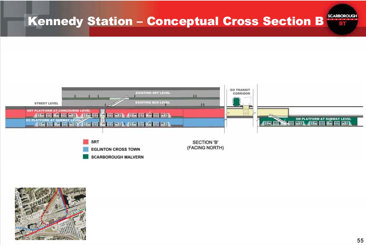
The original plan for Kennedy Station (when the Scarborough network was LRT-based under Transit City) would have seen the new LRT station immediately north of and adjacent to the subway station. It would have been a multi-level station given the number of lines it would serve.
- The bottom level, at the same elevation as the subway platform, would have served the Crosstown (Line 5). This would have provision for eastward extension under the GO corridor and then surfacing in Eglinton Avenue as the Scarborough-Malvern LRT line (now known as the Eglinton East LRT, or EELRT).
- The upper level, at the same elevation as the mezzanine of the subway station and one below the surface bus loop, would have served the LRT replacement for the SRT (SLRT). There would have been a large loop and loading platform at the north side of the mezzanine somewhat like the arrangement at Spadina Station for the 510 Spadina streetcar, but considerably larger given the passenger volumes and size of trains that would operate on the SLRT.
This configuration would give a short transfer connection to the subway via the mezzanine up one and then down one level for the Crosstown, or simply across the mezzanine from the SLRT and down one level to the subway. Connections to surface bus routes would not change.
Drawings for this design are in the following article from July 2016:
Here is a cross section showing the platforms for the SLRT and Crosstown stacked west of the GO corridor, and the SMLRT to the east. It was already in its own station and shows a two-car train rather than a three-car train for the Crosstown and SLRT.
When the City proposed the SSE, the extension included a third track east of Kennedy Station that would be used to short turn half of the peak period service similar to what was done at Glencairn Station on the Spadina leg of Line 1 in pre-pandemic service. This scheme also had the advantage that it could be operated with the existing fleet of T-1 trains on Line 2, and for time there were plans to rebuild these trains for life to 2040 to avoid a new car order.
This is an example of the budgetary machinations needed to keep TTC spending within unrealistic City targets.
Scarborough Councillors and activists objected to getting only half of the full service, and the third track was deleted from the plan. This made the tunnel narrower, and that was the version of the project Metrolinx inherited in the provincial takeover of the SSE.
Subsequently, Metrolinx reinstated the third track causing the tunnel to widen again. (Any decision on the future service plan will affect the size of the new train order when the T-1 fleet is replaced later in the 2020s.)
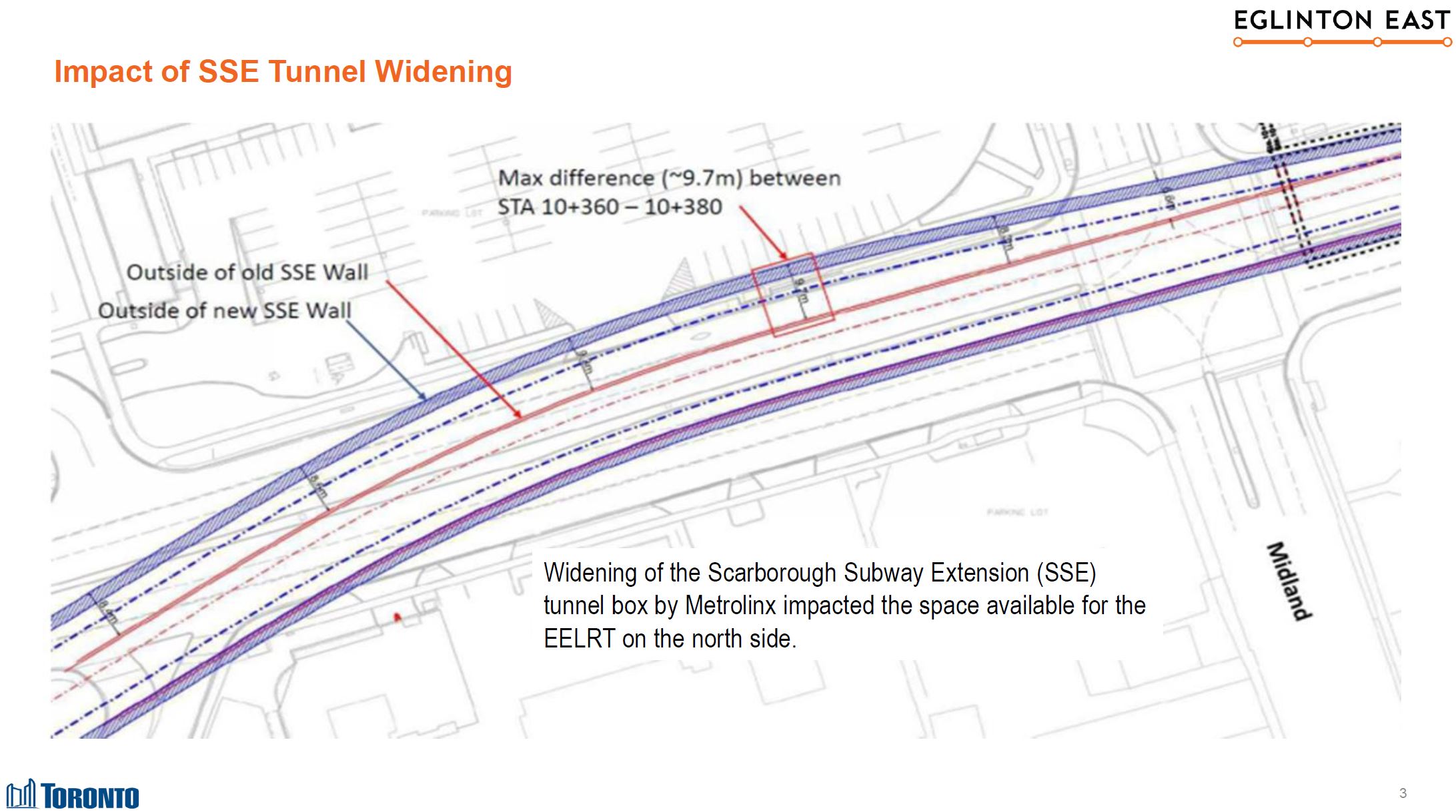
Meanwhile, with the deletion of the SLRT from the plan, Metrolinx changed the elevation of the Crosstown station to be at the mezzanine level as they no longer had to provide for an SLRT interchange. The EELRT, if built as an extension of the Crosstown, would cross under the GO corridor at Mezzanine level and then rise to the surface.
However, the widened subway tunnel does not give enough room for the EELRT tunnel above it, although obviously if this had been designed as a single structure that would not have been an issue. A good example is St. George Station which houses two lines within a single structure. This shows what happens when the province designed its own projects, and the City dropped the ball on necessary integration because the EELRT was much less important politically than the SSE.
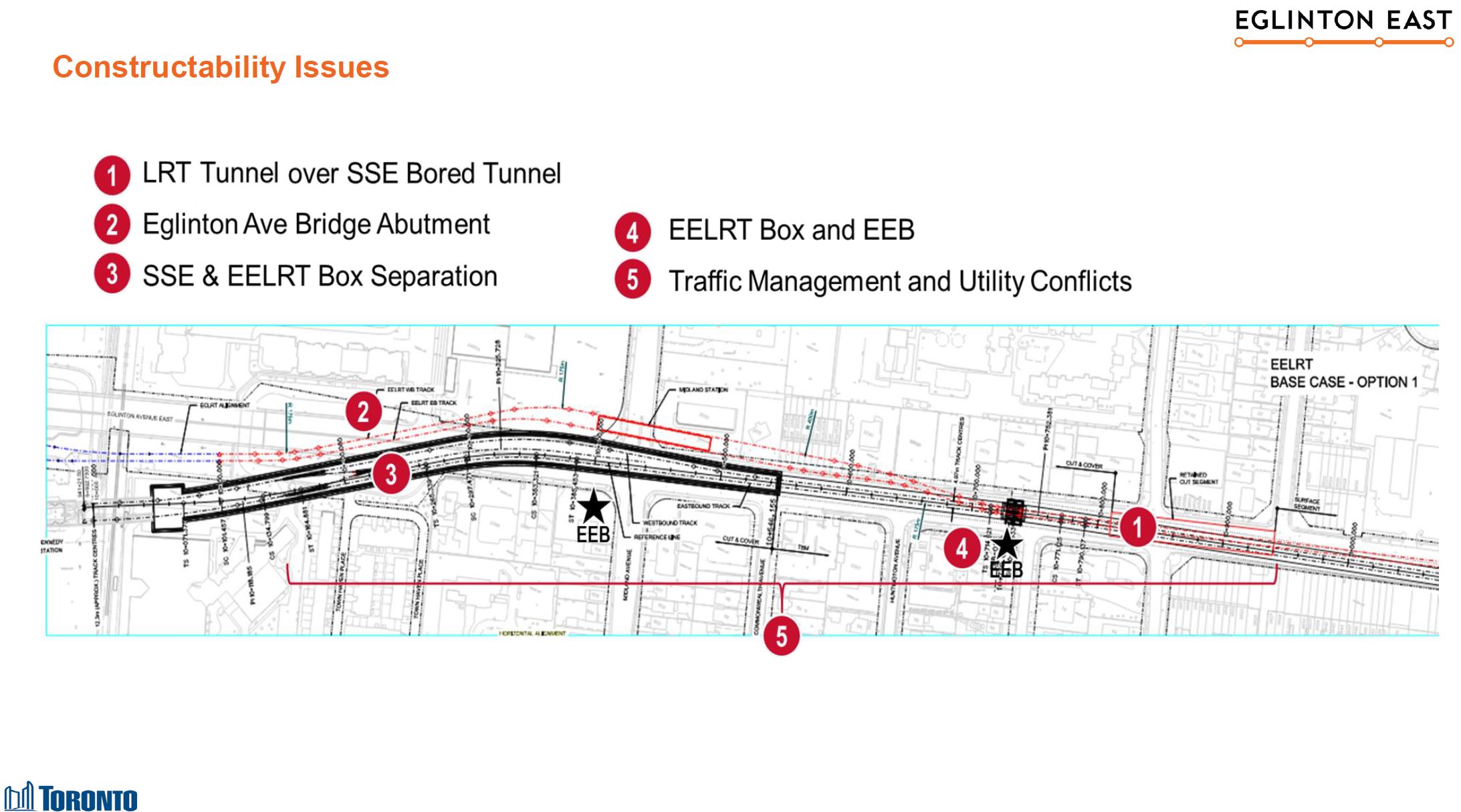
As an alternative scheme, a completely separate tunnel would be needed along the north side of Eglinton for the EELRT. This would be built cut-and-cover given how close to the surface it would have to be, and this would mean the acquisition and demolition of many properties along Eglinton.
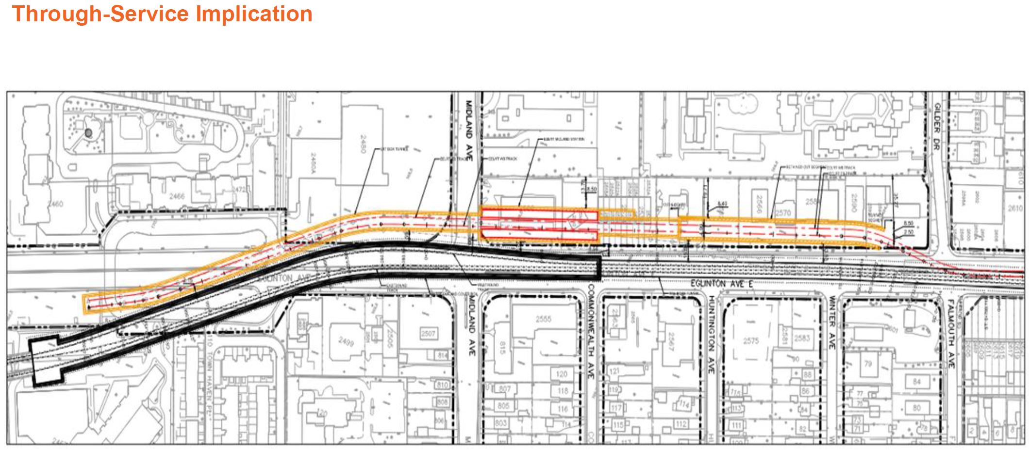
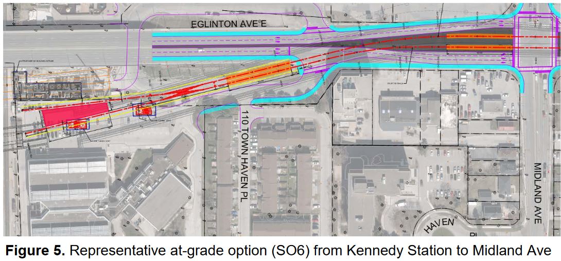
As I reported in a previous article, the EELRT station at Kennedy will now be on the surface south of Eglinton and East of the GO corridor. It will share access to the subway and the Crosstown line via the existing tunnel to the station mezzanine. No details beyond the drawing below have been provided yet.
Council Debate
This is not a full transcript, only the high points. Those who are interested can refer to the video linked above. I have separated questions and comments about the EELRT from those about the Waterfront even though they were actually interleaved.
As a general note, the City plans its next round of consultations in Q1 2023 following the election and with the new Council in place. There will also be an omnibus update to the new Council of the status of transit projects including the EELRT.
Eglinton East
Councillor McKelvie asked what the earliest construction and completion dates could be for the EELRT. Staff advised that construction could start in 2026 aiming at a 2033/34 completion. Staff confirmed that the City has $1.2 billion, previously allocated to the SSE project, set aside for the EELRT. Additional funding will be required for the $2-billion plus project.
McKelvie also asked about concerns raised by TTCRiders about signal priority and line capacity, among other things. Staff confirmed that these will be considered in the work leading to the 2023 consultations.
Councillor Grimes asked where the Waterfront East extension stood in the pecking order of outstanding projects. Staff advised that construction would start in the late 2020s because of co-ordination with other City and Metrolinx projects. It would be in the same general timeframe as the EELRT.
Councillor Ainslie said that according to the Toronto Star, Metrolinx claims that they have not changed the subway alignment and have protected for the Crosstown’s extension. There was a rather woolly discussion between Ainslie and staff about the history were it was clear staff had less info at their fingertips than I provided above. Metrolinx is right to claim they have not changed the alignment per se but they have changed the size of the structure. The City staff appeared unaware of the off-again, on-again saga of the third track and turnback controversy.
Ainslie also asked how the proposed shorter trains on the EELRT (50m vs 90m on Crosstown) would affect stop locations. Staff replied that they are about to work on details of how shorter trains will affect planning as well as service issues such as frequency.
Sheppard
Councillor Pasternak inquired about the project map and specifically the dotted line running east from Don Mills to McCowan. He asked staff what this was and their reply produced much confusion that was never corrected in the debate.
Although Pasternak asked about the pink line which is clearly shown as a Line 4 extension and is described in the report as a subway extension, staff replied speaking of the red line east from McCowan that is the planned northern leg of the EELRT. Because of the confusion, the impression was given that the technology choice for the western portion was still under study by the province when, in fact, this applies to the eastern portion where the city is studying an LRT option.
Nobody at Council appeared to catch this error, and there was some debate about how the subway extension had become a possible LRT line. Councillor Lai from northern Scarborough was similarly confused by the staff error.
Pasternak, as he commonly does, pushed for the western extension of the Sheppard Subway which is in his ward, but which we are unlikely to see for a very long time.
In any event, Sheppard West will be covered in the update planned for 2023, and this will take into account planned development in the Downsview Airport lands.
The SSE technology choice might be behind us, but this does not prevent tangled debates by Councillors with their own agendas.
Waterfront
Councillor Grimes (who hails from southern Etobicoke) asked where the Waterfront West LRT project stood considering the scale of development in the Humber Bay area. An alignment for the LRT through a revamped Western Waterfront park and road system between the Exhibition grounds and the Humber River was approved by Council over a decade ago, but little work has been done on this as it is unfunded.
Detailed design of the segment from Exhibition Loop to Dufferin has resumed after a pause to sort out potential conflicts with the Ontario Line. A new Dufferin Street bridge over the GO Lake Shore corridor has been planned including provision for a link to this segment. This project is not funded beyond the work to reach 30% design. There is no funding for design further west.
The approved alignment would shift Lake Shore Boulevard to the north in the Sunnyside area to consolidate open space to the lake side (south) of the road. An LRT right-of-way would parallel Lake Shore to Colborne Lodge Road where it would turn north under the GO corridor and link to existing track on The Queensway. Other proposed connections, notably at The Queensway & Roncesvalles, would make the intersection even more complex than it is already, and would almost certainly be a choke point for any through service.
The 2008 plans are available in Waterfront West Reference Material.
Councillor Grimes asked whether the Waterfront West line should take precedence, although he appeared to be unaware that the Waterfront East project is much further advanced in design, and will serve an area that is rapidly growing without good transit service. This is the kind of move that has sandbagged so much transit work in Toronto because there is always some project with more political clout, more squeaky wheels, and we plan on the basis of “if you get yours, I won’t get mine”.
Councillor Mihevc (who has replaced Councillor Cressy for the remainder of this term) argued that the WELRT was always to be one of the key city projects going back to the Lastman years. He understands that with funding, staff could to 60% design by the end of 2023. This would give the city a “shovel ready” project should additional infrastructure funding appear.
Deputy Mayor Denzil Minnan-Wong, who can always be counted on as the dog-in-the-manger of Council debates, asked about cost overruns on the Harbourfront project. He appeared to be fishing for staff support for foot dragging on an accelerated design effort for the WELRT trying to get staff to say that “rushing it” is a bad idea. He also portrayed the line as if it were to be substantially underground (and hence below the water table) as opposed to the eastern portal at Bay and Queens Quay.
His arguments played mix and match with multiple parts of the Harbourfront project including cost overruns that were not the fault of transit per se but of work on other utilities. He raised the issue of motorists driving into the Bay Street tunnel although this issue was, finally, resolved by installation of a gate that opens only when a streetcar is present.
Motions
The report was adopted by Council with the following amendments:
By Councillor Mihevc:
- City Council direct the City Manager to determine potential undertakings to expedite the budgetary and design processes for the Waterfront East Light Rail Transit line.
- City Council direct the City Manager to engage with officials of the Provincial and Federal Governments to identify and secure funding to advance the Waterfront East Light Rail Transit line as expeditiously as possible.
By Councillor Grimes:
- City Council direct the City Manager, as part of the report back in Executive Committee Recommendation 8, to determine potential undertakings to expedite the budgetary and design processes for the western extension of the Western Waterfront Light Rail Transit from Exhibition Place Loop to close the gap on dedicated streetcar right-of-way service between Humber Bay Shores and Exhibition Place.
- City Council direct the City Manager to engage with officials of the Provincial and Federal Governments to identify and secure funding to advance the Waterfront West Light Rail Transit line as expeditiously as possible.
The main recommendations, in brief, are:
- That the design work be advanced to 10% for the “distinct option” of the EELRT between Kennedy Station and the future Sheppard-McCowan station, and that City staff work with the TTC to assess suitable vehicle options for the line.
- That staff report back to Council in 3Q 2023 with a Class 4 estimate for the 10% design.
- That staff report back to Council in 3Q 2023 with an updated Business Case for the EELRT.
- That Council request Metrolinx to work with City staff to protect for connections at Kennedy and at Sheppard-McCowan stations for the EELRT.
- That Council request the Ministry of Transportation to include provision for the EELRT in design for rehabilitation of the Morningside-401 overpass.
- That Council confirm that the Conlins Road property owned by Metrolinx is the preferred location for the Maintenance Facility for the EELRT.
- That staff conduct a constructability review of the WELRT including revisions to the Bay Street tunnel and assess co-ordination risks with other nearby projects.
- That staff report to Council in 2Q 2023 on the recommended scope, alignment, cost estimates, financing and staging plan for the WELRT.

Warden Stn is often used to short-turn the Line 2 trains. Do not remember if it has a third track already. But even if it doesn’t, adding one shouldn’t be very difficult as the station is located above ground.
It would be great if Metrolinx took the LRT connection into account while designing the SSE route near Kennedy, and settled for the third track at Warden instead of Kennedy. Then we wouldn’t have the EELRT connection problem today. I guess it is too late now, as the tunneling contact has been signed.
If the full connection between ECLRT and EELRT is no longer possible, would it be useful to build a non-revenue connection, so that the trains can be moved from one line to the other if needed? That non-revenue connection could run in mixed traffic, in the two central general-traffic lanes of Eglinton. It wouldn’t be in use for the normal operation, but could come handy when, for example, some maintenance is being done in the middle of ECLRT route, and thus the eastern segment is temporarily cut from the Mt Dennis yard. During such a period, that segment could be serviced from the Conlins yard.
Steve: There is a tiny problem with your proposal in that Eglinton goes over the GO corridor on a high bridge, and adding trackage to link the two routes could be tricky.
At Warden there is no centre track. If they short turn trains, they just drive across the crossover. That works for occasional movements, or when the line is shut down east of Warden, but not for a scheduled turnback where the short turn train has to merge into westbound traffic. There isn’t enough room to add a pocket track east of the station before the line narrows and enters the tunnel portal.
LikeLike
Regarding the Waterfront West LRT, seeing that we will be getting high frequency GO service from a new Park Lawn station does it still make sense to fill in the gap between Park Lawn and Dufferin in your opinion?
Steve: So far, GO has not proposed particularly high frequency service at Park Lawn. If this project is done as part of a realignment of Lake Shore, it should be comparatively cheap and will allow “Lake Shore” service to bypass an otherwise slow congested route to downtown via KQQR, King and Dufferin.
LikeLike
Forgive me if I sound like a newcomer but it appears to me that there is an issue with the separate approach to development of the East Waterfront and West Waterfront Light Rail. I assume as you point out that one area does have more need than the other (east is underserved) but it feels like this separateness represents a piecemeal approach to transit at large. Shouldn’t in effect the entire Waterfront line be completed at approximately the same time? Then conceivably people can travel on one long system route from east to west across the waterfront? I come at this question from the perspective of the regular user who wants a fluid system without many transfers. Thanks.
Steve: The western portion of Queens Quay was developed starting a few decades ago. One of the first, Harbour Square, is 45 years old. The eastern waterfront developments are more recent and they were spurred in part by promises of an LRT line that has not yet materialized. There is also the Villiers Island plan which is a huge reclamation and flood control project that makes an eastern anchor for that development south of the rail corridor. Toronto has been so pre-occupied with the weeping and wailing from suburban politicians that focus has been on their new subways while the plan for the WELRT languished. It did not help either that some who are big fans of the Ontario Line (not to mention SmartTrack before it) touted these as the one and only “solution” needed for the eastern waterfront even though they would not serve this land well.
This is the typical of a view of transit that assumes a station can be “convenient” if it is a 10-15 minute walk away. For example, the western end of what will be Villiers Island is almost 2km away from both the future East Harbour or Corktown Stations, and it is further still to lands south of the future Don River outlet.
LikeLike
Hi Steve,
I have been particularly interested in the Waterfront West LRT because at one time I lived in the area, still have family there, and because I have often used Sunnyside Park and Pool. I realise that it is low priority to, say, Waterfront East.
I was wondering what exactly is the reason for this project. The 2008 material which you provided was very informative. The purpose stated then was to enhance accessibility to lakefront parkland. By re-aligning Lake Shore Blvd. closer to the Gardiner Expressway, the area of parkland would increase by up to 41 acres.
The 2008 material also shows LRT extensions from the east and various configurations vis-a-vis the Queensway car.
Now, I am reading that WWLRT would enhance commuter travel to downtown.
However, that only gets the commuters to Harbourfront. A Front Street car would be much more useful. But there are the plans to rebuild the Union Station car loop.
Besides, where are they all coming from that they need the WWLRT to commute downtown?
I personally would enjoy and use a direct link from Sunnyside to Harbourfront. The missing portion is by the Exhibition grounds.
Steve, you mentioned a possible connection of WWLRT to the Queensway via Colbourne Lodge, which is in the 2008 materials. I started thinking about other possibilities. Darn, where are my crayons?
I was thinking, why Colbourne Lodge, why not Ellis or Windermere? That would give more frontage lakeside. However, if the LRT is in a median ROW on Lakeshore Blvd., it needs to cross auto traffic. The Lakeshore ramp west of Windermere is really part of the Gardiner Expy. and not suitable. How about if the ROW went around south of there instead and met up with Humber Loop?
I was thinking, the 2008 material mentioned rejigging the Parkside-Queensway-Lakeshore intersection. What if the LRT went up Parkside? How far? – to Bloor St.at Keele Station, or to Annette, or to Gunns’s Loop? Keele between Junction Road and Dundas St. is a bottleneck. (But in the old days streetcars ran up this way.)
I was thinking, a simple connection for WWLRT is to meet the streetcar at Dufferin Loop. The King car is very quick to/from downtown and Dundas West Station.
I was thinking, do we really need both a Queensway AND a Lakeshore Blvd.? If we had one roadway and one streetcar ROW?
Kind regards, Peter
Steve: Two points. First, I think that you have too many crayons.
Once upon a time there was direct service to downtown from Long Branch, and the WWLRT was primarily intended to give that a bypass around congestion at KQQR and points east. I think that the potential benefit for Humber Bay residents is somewhat overblown unless the TTC is going to run frequent service, and even then it won’t be exactly speedy from Exhibition Loop east to Union.
The idea of going north makes even less sense. If people want to get to the Bloor subway, they can do this via north-south routes in Etobicoke. Further north even less sense.
LikeLike
Hi Steve,
I am wondering about the SSE and the Sheppard subway extensions. Will they interline (ie. connect tracks) or merely pass each other by?
If I understand correctly, Sheppard trains are shorter. Are the station lengths shorter, also?
Steve: The lines are planned to operate separately probably with overlapping stations at Sheppard & McCowan. Line 4 trains are only 4 cars long although existing stations have provision for extension to 6-car length. Whether there would be enough demand is another matter.
LikeLike
It would, in an alternate reality where we had political will to build a dedicated transit right of way on entire Front Street West. As it stands, there is a right of way on Fleet and Queens Quay reaching Front Street, Union Station and the continuing growth in office towers around it, and connecting to subway and PATH for points further north.
South Etobicoke. It’s not a large market, but it is a market, and could conceivably grow if transit becomes a more attractive option. There is a considerable amount of new residential towers at the mouth of Mimico Creek, and further down in Mimico-by-the-Lake there are some older higher-density residential buildings.
The best option from South Etobicoke to downtown would be frequent GO service from Mimico station and future Park Lawn station, useful TTC transit service to these stations, and free or considerably discounted transfers between GO and TTC. But GO service and fares are not controlled by City of Toronto, and so far GO has focused servicing on 905-suburb rather than 416-suburb market with no indications they seriously plan to change this on Lakeshore West. Thus was conceived the WWLRT, as a line that is under Toronto’s control.
Keeping the line on Queensway between Ellis and Humber allows the LRT to service the new residential towers that have been built there. Ellis would be an option, but I think it has more car traffic than Colborne Lodge since it links to some residential areas north of Queensway. (I guess I shouldn’t hold my breath for Colborne Lodge to be closed to cars as part of WWLRT, but it would be nice.)
There isn’t really room for an additional Humber crossing south of the Gardiner without getting into super-pricey options like a tunnel.
Well, no, the King car isn’t very quick. It takes the TTC 30-40 minutes to get from KQQR to Bay on a normal day. The basic idea of WWLRT is to allow bypassing the street-running segments through Parkdale and King/Queen West by linking into the Harbourfront dedicated right of way. Linking Dufferin to Exhibition is the planned first step of WWLRT (hopefully not the last step that will actually be built), but neither Queen nor King cars are particularly fast through Parkdale, the required turn at Queen to Dufferin would be very awkward due to vertical geometry (the required legs of Queen and Dufferin slope down considerably into the intersection), and any route still has the problem of delays at the pinch point at KQQR.
Steve: In fact the TTC explicitly rejected a proposal to add curves in the SW quadrant at Queen & Dufferin because of the grade.
Thanks for going into a detailed reply to this. I didn’t have the heart to spend time on what is basically a fantasy map exercise by someone who does not appear to know the area well.
LikeLike
I thank Jarek for those well thought out comments in response to my post. Much appreciated!
However, Steve, you did not catch the purpose of my post. A bunch of times I started an idea with “I was thinking”. Whether I was daydreaming or thinking “outside of the box”, or both, I was going through ideas and possibilities for the WWLRT. Many times we have seen Metrolinx & TTC planners and politicians go after an idea and unable to see any alternatives.
And, Steve, I grew up & worked in Parkdale, which is why my second language is Polish! My wife lived at Springhurst & King many years and she could tell you lots about the King and Queen cars.
Incidentally, we were around Sunnyside and downtown for several days this week, both on TTC and driving, all over town. We were even on Broadview north of Danforth. Yes, what I experienced contradicts some of what I said.
Perhaps on a bad day. From KQQR to downtown or return, there are hiccups at Jamieson and then between Spadina and University. Otherwise, it is clear sailing. However, if the westbound car loops at Dufferin, that can be a significant delay.
The connection of WWLRT to Dufferin Loop was on several maps of the 2008 material. It is an obvious connection. No inference that the WWLRT was going further north, to King or Queen.
Steve: There have often been proposals for an “interim” service rerouting the 508 Lake Shore to downtown via Dufferin and Harbourfront. I am not sure how beneficial this would be especially if there will be a period with no access to Union for reconstruction as part of the WELRT project. My concern is that this seems to be considered as an “interim” arrangement that might be claimed as the “WWLRT” without really contributing much, particularly if 508 service is infrequent.
Parkside extension – ok, this is fantasy. I just drove Parkside south from Howard Park. The catchment area is limited with High Park occupying the entire west side of the street, and Roncesvalles is not too far. Did not see any bus.
Those new towers are right next to the eastbound Gardiner Expressway on the south side. That means that best access to the buildings is from Lakeshore Blvd., not from The Queensway.
Yeah, it is very tight there, condos right at the curb. Awful planning. What I had in mind was that if the LRT did not have to cross westbound Lakeshore lanes from a ROW in the median. Whatever the solution, expensive or inconvenient, or both.
Further to moving Lakeshore Blvd. to adjacent the Gardiner in order to create an extra 41 acres parkland, maybe not such a great idea. There are many mature trees that would be destroyed.
Further to LRT on Front Street – also impossible, unless all vehicular traffic except taxis is taken off of Front St.
Thank you for your patience.
LikeLike
Regarding connecting WWLRT to Dufferin Loop, Steve said:
I share Steve’s skepticism about the WWLRT, “particularly if 508 service is infrequent.”
But, the missing link between Exhibition Loop and Dufferin Loop is exactly one kilometer of city-owned land along the north edge of the CNE grounds. No demolition, no expropriation.
Note: the McDonalds at the SW corner of King & Dufferin (where I had gone many, many times) was recently closed. Perhaps the city should ensure that the streetcars have sufficient turning room? Note: the plaza at the SW corner of Queen & Dufferin was recently closed. Perhaps the city should ensure that the streetcars have sufficient turning room?
Steve: There is a development planned for that corner and I don’t think they will be too happy about giving up road space. The new building comes to the lot line, and the old bank is preserved.
Looking at the 2008 maps, that was a fantasy at that time. We really do not need to put streetcars on Lakeshore Blvd. at Humber Bay.
I was asking, “…where are they all coming from that they need the WWLRT to commute downtown? Answer was – just local commuters.
Therefore, we need just a simple connection for people to get downtown, nobody transferring from other lines such as GO. Therefore, the missing piece along the CNE grounds should be built.
LikeLike
As for the WELRT, does anybody remember that time last winter when I reported a ride down Parliament by streetcar from Carlton to King? It was due to construction disruptions.
Yes, I am back to advocate for the restoration of the Parliament car. From Castle Frank station down to the WELRT.
Oh, c’mon Steve, this is in your neighbourhood, say yes to this!
Steve: No. Aside from structural issues at Castle Frank, Parliament is a woefully slow street with more traffic lights than people, and it is too narrow for any sort of priority scheme.
LikeLike
Steve, there is plenty of room for a streetcar loop at Castle Frank station. I was there a few days ago.
Steve: The curves are too tight and there are structural problems supporting the weight of track and streetcars. This has been reviewed before.
Parliament is much like Roncesvalles. Traffic moves very well. I do my shopping there. A nice neighbourhood.
Steve: I know it well, but there is not enough demand to warrant conversion to streetcars. And there are a lot of delays at traffic signals.
LikeLike
I’m not sure what to tell you. This Wednesday afternoon it took me 48 minutes to get from boarding the streetcar at King and Bay to Roncesvalles. This included a transfer to the bus which added probably 5 minutes. But that is not what I consider fast. Every afternoon, the streetcars are held up in entire downtown core by inconsiderate drivers blocking intersections trying to get to the Gardiner (another reason why Queens Quay, being south of Gardiner, has an advantage).
Steve: This was a problem in pre-pandemic days with traffic backing up across King, notably at University. Where are the traffic wardens Mayor Tory promised us to deal with this sort of thing?
I looked at the stats for 504 King, and the travel time from Yonge to Dufferin varies by time of day over a band from 20-30 minutes with most values concentrated between 20-25 except on days where some external event such as construction screws up the route. As for the King bus west of Dufferin, that’s quite another matter.
If you’re looking for fantasy streetcar extensions, Dufferin from CNE to somewhere north of Bloor (Galleria? St. Clair? Eg?) seems a much better location. Parkside Drive is “served” by the Queensway bus, which runs once in a blue moon and less often on weekends (signed – someone who might consider going from south end of Parkside to the Queensway retail strip). Its main purpose is probably to have a line on the map to show that the area is “within transit service”.
Steve: Actually, the main purpose is to connect the Queensway bus to the subway. It was one of the few routes that did not serve a subway station in its original Humber-to-Sherwy configuration.
No, I mean the towers along the Queensway. South of Queensway, north of Gardiner. Look around the intersection of Queensway and Windermere. There’s also more higher-density buildings stretching north of Queensway on Windermere, Coe Hill, and Southport that are within a decent walk.
The main locations where moving Lake Shore Blvd would be beneficial are at Jameson where there are no trees in the way, and at Palais Royale where both directions could fit in the space currently occupied by the four (!) westbound lanes.
The new residential building on the southwest corner of King and Dufferin already has several floors up. A bit late to be suggesting changes to those plans.
LikeLike
“Councillor Grimes (who hails from southern Etobicoke) asked where the Waterfront West LRT project stood considering the scale of development in the Humber Bay area.
An LRT right-of-way would parallel Lake Shore to Colborne Lodge Road where it would turn north under the GO corridor and link to existing track on The Queensway. Other proposed connections, notably at The Queensway & Roncesvalles, would make the intersection even more complex than it is already, and would almost certainly be a choke point for any through service.”
The Colborne Lodge alignment was chosen, and if I see it built in my lifetime it will be a miracle, but for the record there are obvious benefits to crossing over further east, most of which were ignored during the consultation process. The most important is that you connect that higher order rapid transit to St. Joseph’s, obviously an extremely important healthcare facility for west Toronto and a major employment centre. Although Perks claimed, in front of executive committee, that it was “just a couple hundred metres to the west” to walk to Colborne Lodge Dr. it is in fact at least 700m. Even the proposed new pedestrian overpass was hundreds of metres once you walked to it, across it, and then to the proposed stop location – not to mention you would need an elevator or a very long and slow descent for accessibility reasons. Asking dialysis, chemotherapy, last trimester, and other patients with poor health and/or mobility to walk that far – or over the Gardiner/rail/LSBW corridor, particularly in winter or bad weather – is terrible planning for a new LRT corridor. Then there’s the fact that you have the construction and maintenance costs of 1+ km of parallel (I would say redundant) track. I don’t agree that it would complicate the KQRQ intersection because it would make more sense to start crossing over the corridor to the west of the intersection, more or less across from the Roncesvalles car barn. Maybe that would be technically difficult, but no more difficult than countless other engineering challenges addressed in other transit infrastructure projects in the city. You may ultimately be right, but the fact is we don’t know because the alignment was screened out before it could benefit from a preliminary design and the St. Joe’s connection was important enough to look harder. And it’s really the only complicated piece in what is otherwise a pretty short, straightforward project with no tunnelling and incorporation of existing ROW segments.
“Rapidly growing without good transit service” also describes Humber Bay Shores pretty well, and it’s 3-4 times more distant from Union Station. After the Christie’s site is developed it will be ~30K residents in less than 1 sq km with only a GO station and surface transit running in mixed traffic if WWLRT is not built. That’s insane, and developers are asking for fewer parking places because it’s a “Transit Oriented Development” that they are getting away with comparing to Liberty Village and Dundas-Bloor. Even the streetcar loop design for the Christie’s site, which the TTC says should be designed to handle up to 24 streetcars per hour (6xEB 501, 6xWB 501 and 12×504) has only one layover for the 12 504s per hour terminating there! Sure hope they are “on time” or that second 504 will be blocking all the 501s too.
I would add to your comments, Steve, that GO is not well connected to the larger transit network. There are lots of places that the Park Lawn GO station will not help you get to. It also needs to be emphasized that not everyone’s travel begins and ends within walking distance of GO. If you live at HBS and work near Union, that’s great. If you don’t, current return cash fare to combine GO and TTC Mimico to Union is $13.80. I don’t think a whole lot of people can afford to pay that kind of double fare on a daily basis. The median annual household income in Etobicoke-Lakeshore was $72,000 in 2015. A GO station is necessary and smart, but there are almost 20 GO stations in Toronto, and none is the only higher order transit for an immediate community of 20,000, soon to be 30,000, not to mention the wider ridership watershed for this location which will be 72,000 by 2041 (the Transportation Master Plan planners are anticipating a transit mode share of 52% for those 72,000 by the way, with just a GO station and streetcars and buses!).
I think long term, one of the best features of WWLRT is that while you might travel through to Harbourfront or Union, from the west you would likely see much more ridership transferring to Ontario Line at Exhibition Station, which is great, because you aren’t adding more streetcar turning movements at places like Bathurst and LSBW – you can probably run fewer 509s and just interline the WWLRT cars through.
As far as your skepticism, it is well founded. A TTC planner told me during the Waterfront Reset consultations that once you have that Dufferin-Exhibition connection it’s basically the same thing as WWLRT. That should have been a sign…
Steve: That tell me that the “TTC Planner” has never looked at congestion statistics for King between Dufferin and The Queensway. “LRT” it isn’t.
LikeLike