
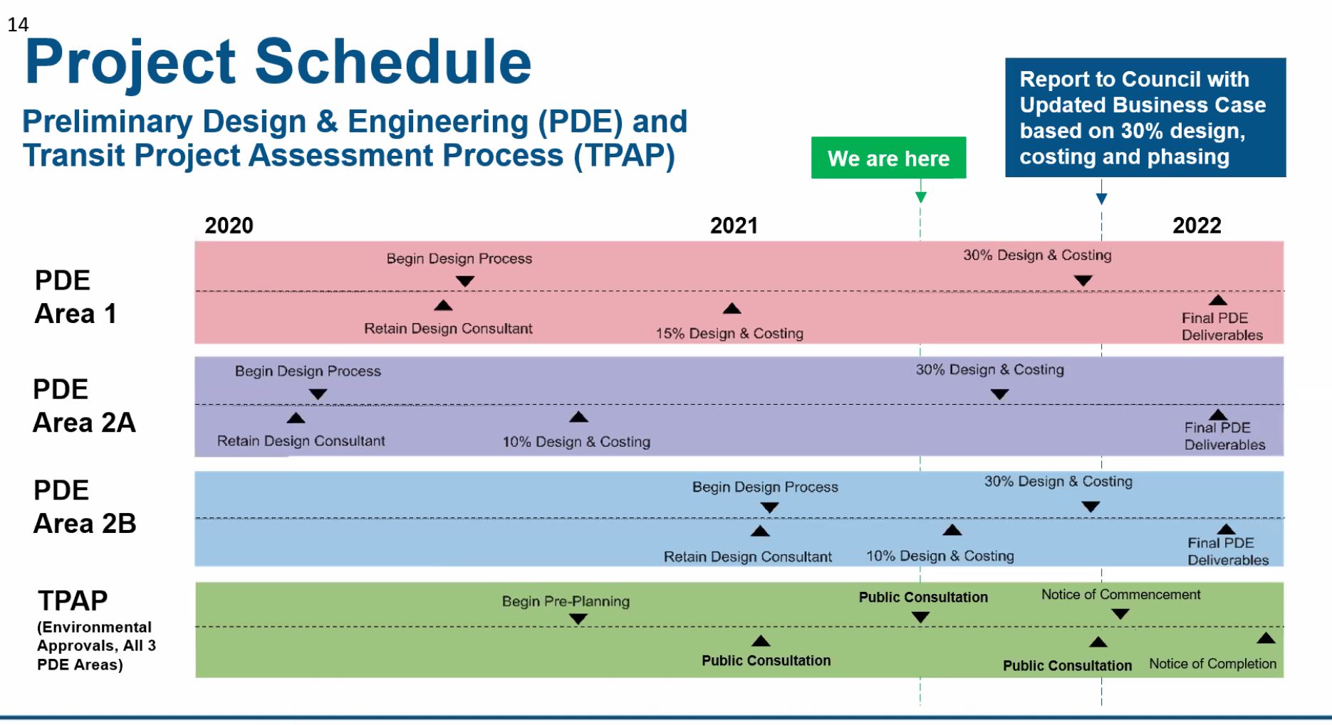
Various projects for transit in the waterfront are working their way through a Waterfront Reset process. On July 7, 2021, there will be an update to Toronto’s Executive Committee on the status of transit projects including the Waterfront East LRT. Staff hope to take an updated Business Case based on the preliminary design to Council in Fall 2021.
The City of Toronto, Waterfront Toronto and the TTC held an online update and consultation session for the Waterfront East project on June 21, 2021. This covered several points and included significant changes in scope and design.
- The new Union Station Loop will be fully built in one stage rather than a half-now, half-later approach. The full capacity of the new loop will be required to serve development underway and planned in the waterfront.
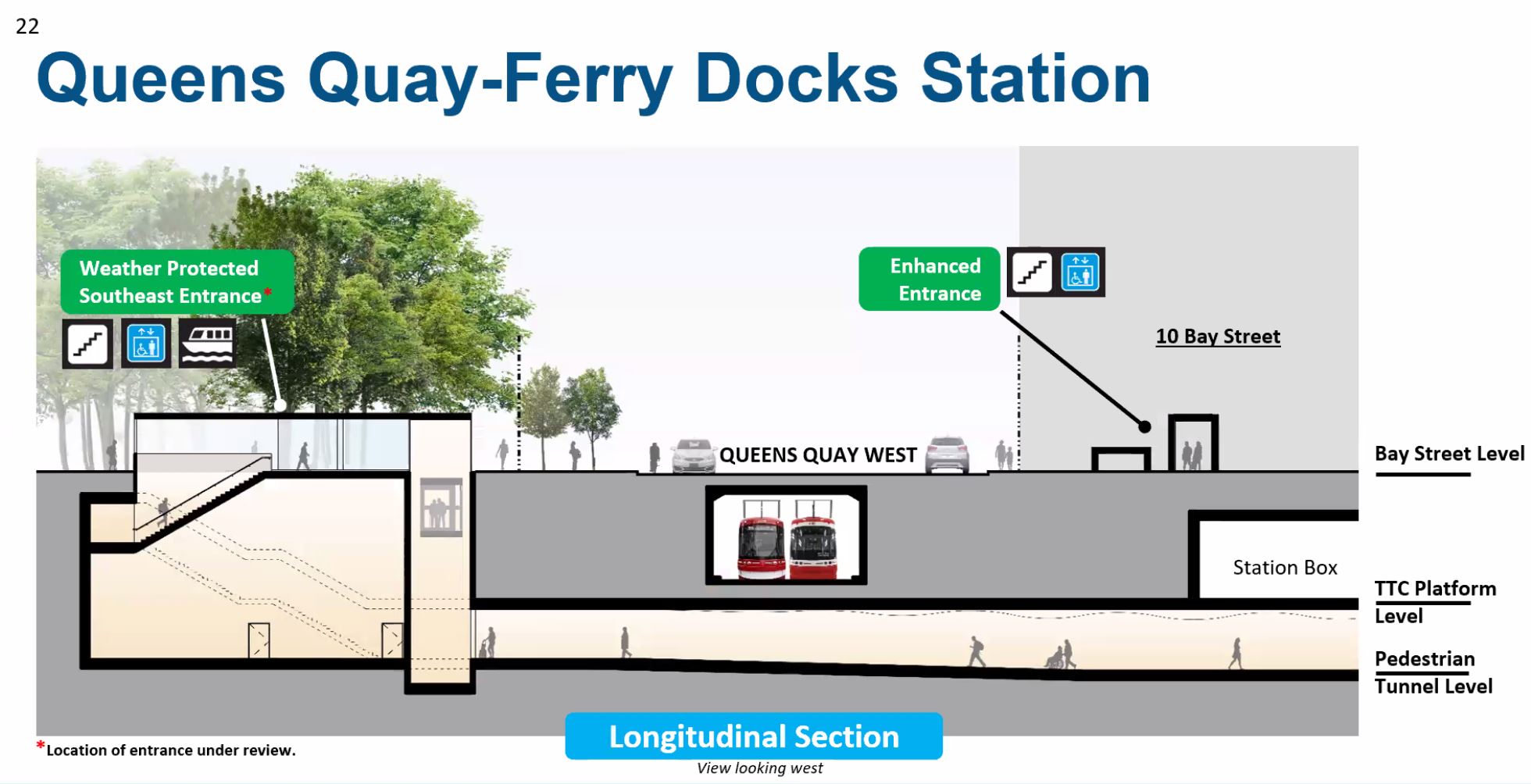
- The new Queens Quay Station will include connections (some provisional) to adjacent buildings and to a tunnel under Queens Quay to the Ferry Docks.
- The eastern portal location will be west of Yonge Street in front of the Harbour Castle Hotel. The hotel’s entrance will be relocated to the eastern face of the building at a new entryway to be constructed by extending Yonge Street southwards over what is now the Yonge Street Slip.
- The western portal will receive an architectural treatment that will echo the new east portal.
- The work will be staged so that through streetcar service could operate to the eastern waterfront from existing trackage on Queens Quay West while the Bay Street tunnel is closed for reconstruction of the stations.
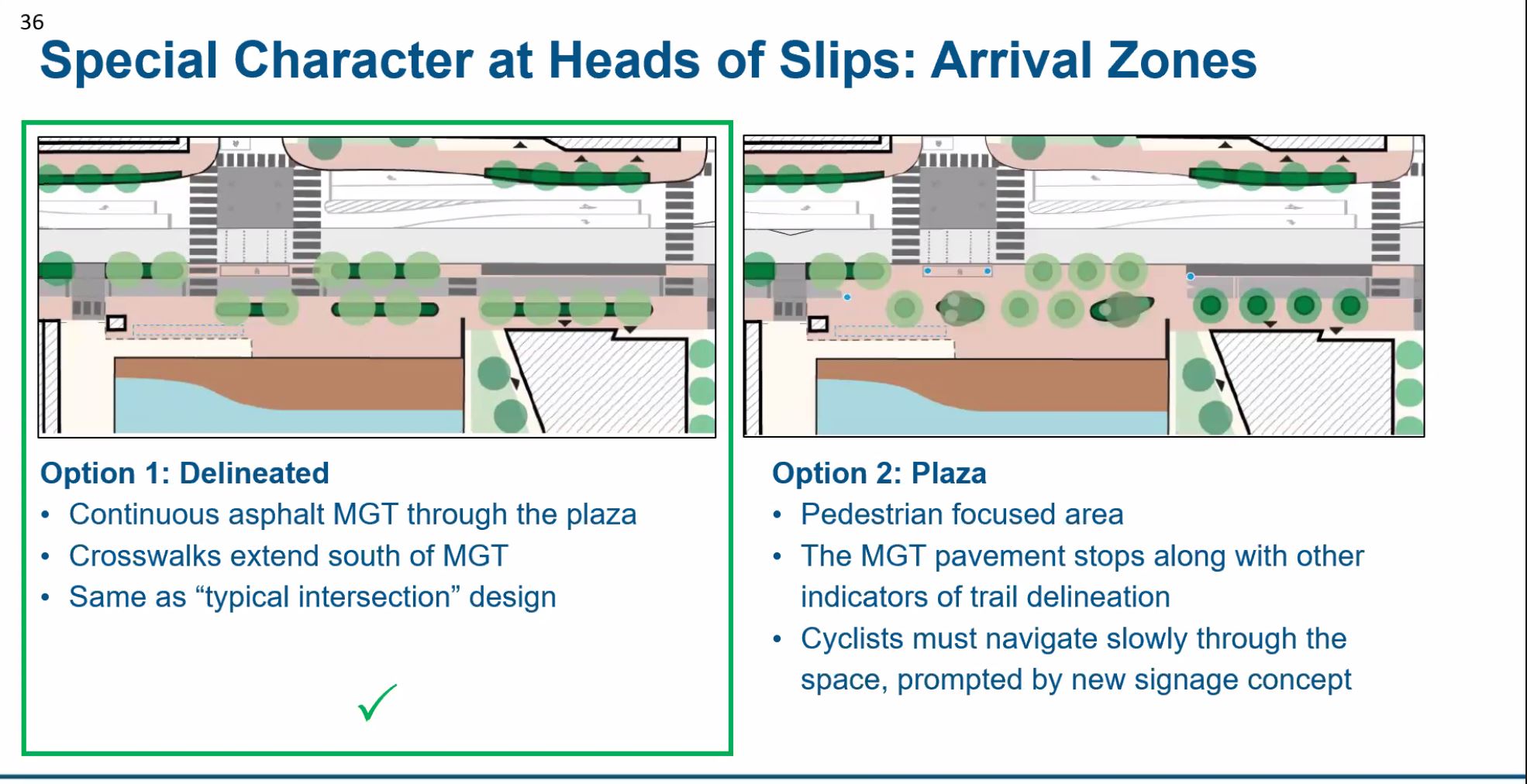
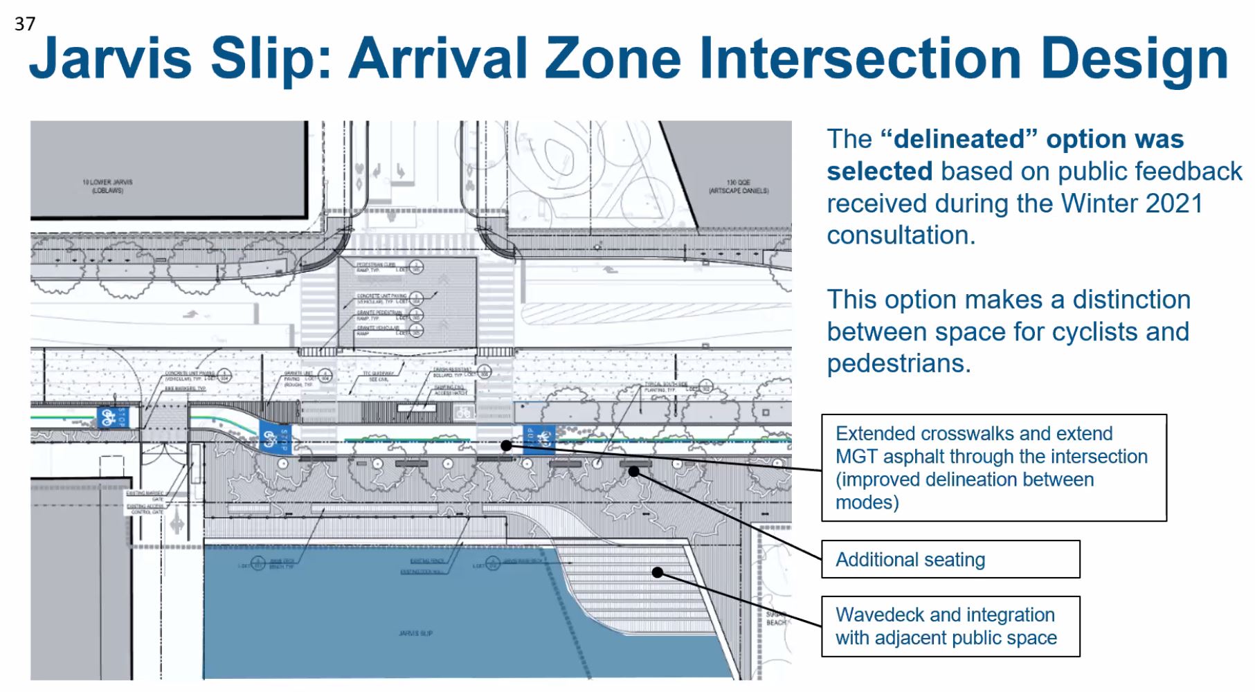
- Queens Quay East will continue a street design similar to that on the portion west of Bay with modifications to better clarify the pedestrian and cycling areas.
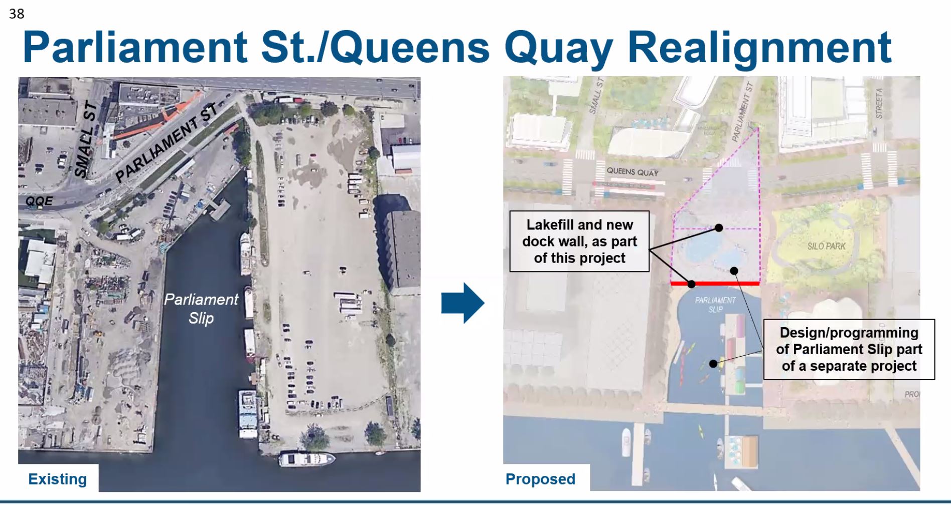
- As previously planned, the Parliament Slip will be partly filled to allow extension of Queens Quay directly east to meet a realigned Cherry Street. This design is no longer entangled with plans advanced by Sidewalk Labs.
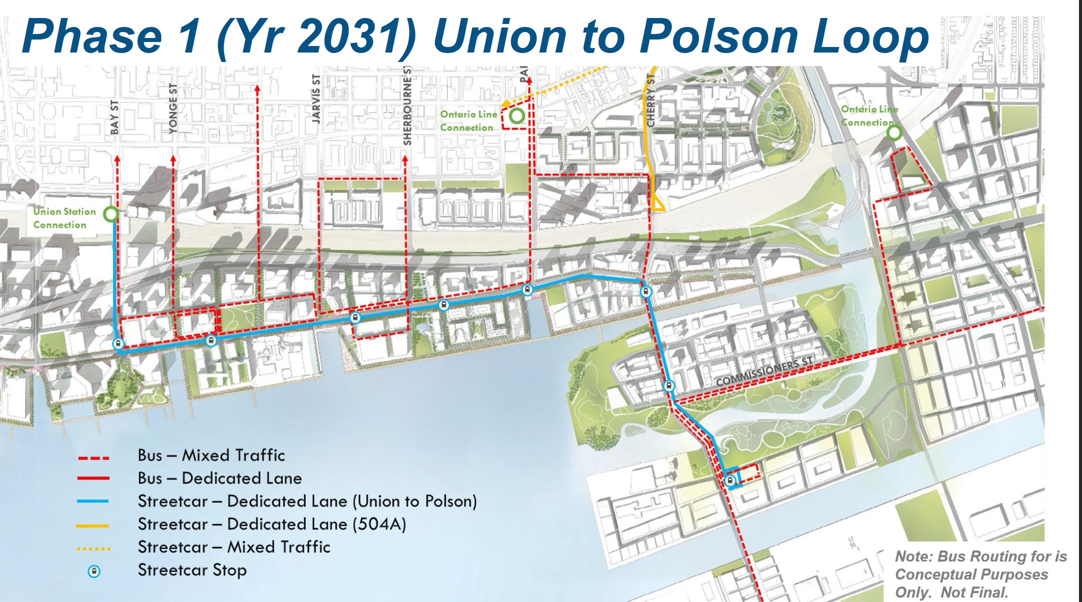
- The first phase of streetcar service will extend east to Cherry and south to a new loop at Polson Street.
- There are four options for the connection north via Cherry to Distillery Loop one of which would require relocation of the existing (but inactive) Cherry Street Tower in the rail corridor which is now immediately south of the loop. The most likely of these is a new portal for the streetcars east of the tower.
- Following construction work on Bay Street, the surface level will be redesigned to improve its appearance and provide more room for pedestrians and cyclists.
The City’s presentation deck is arranged slightly differently from the sequence in this article because they focused on design exercises for each segment of the line. Here I have tried to pull some related matters together.
Union Station Loop

The reconstruction and expansion of Union Loop is critical to the Waterfront network meeting its eventual capacity and purpose. The existing loop and platform were too small when it opened and have been a bottleneck under busy conditions ever since.
The new loop’s platforms will extend down much of the length of the teamways above to the south end of the rail viaduct. There is provision for two Flexitys to unload northbound and two to load southbound where there is now only room for a single car on the loop track at Union.
Space for circulating and waiting passengers is much expanded, and there are lateral connections to other buildings such as Union railway station’s Bay Concourse and the new bus terminal. The entire loop will be a “paid area” as shown in the drawings, and there will be no fare line between the loop and the subway station.
The track layout includes a double crossover on each platform allowing cars to bypass each other if need be. This avoids problems that now arise when cars on different routes prevent each other from leaving. The separate platforms for each route will allow concurrent loading.
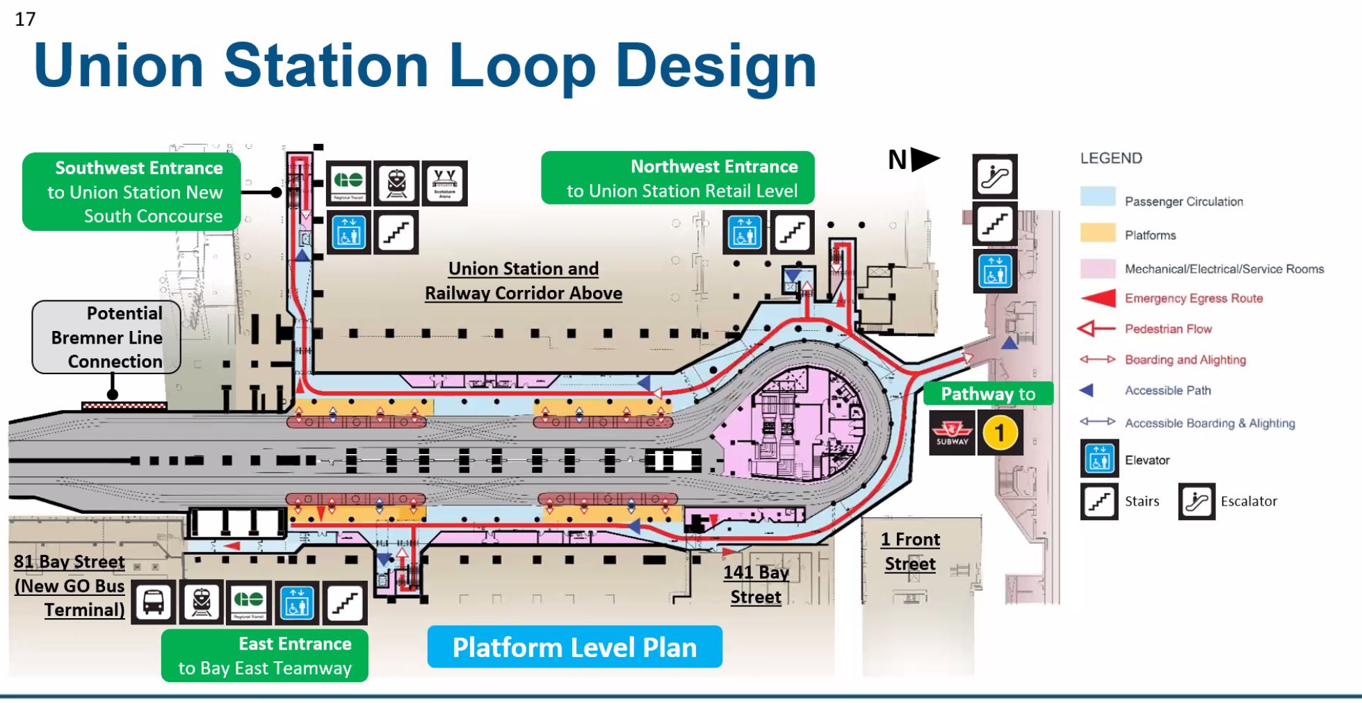
Among the challenges of designing for this space are the existing structural supports for the railway and the fact that various parts of the transit and railway stations are not at the same elevation. The Bay Concourse in the railway station is at roughly the same level as the mezzanine in the subway station, while the streetcar loop is at subway track level one storey down. Any link between the loop and the railway concourse requires a stair and elevator (there is no room for an escalator).
One major change that is not obvious on the drawings which only show the new configuration is that the track level will be lower than it is today. This provides additional space for air circulation and fire control.
The first drawing above shows doors at the entry to the platform areas. These will normally be locked open with magnetic latches, but can be closed in case of fire. The cross section shows another element of a smoke control system, a half wall hanging from the ceiling at the platform edges.

Queens Quay Station
Queens Quay Station currently has capacity for one Flexity to load in each direction. It will be extended north to provide space for two cars in each direction. Unlike Union, tracks at this station will remain at their existing grade.
The first image below shows a 3D view of the station looking southeast, and the second one shows a plan view.
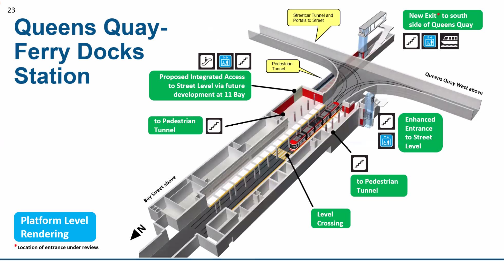
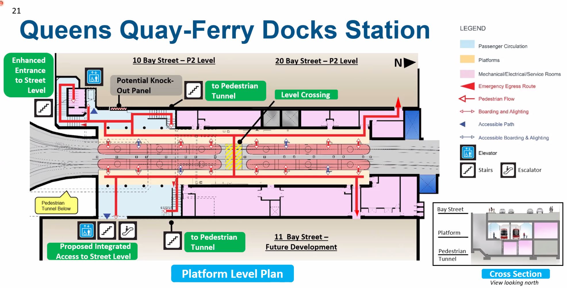
The station includes links downward to a tunnel crossing under Queens Quay to a new exit north of the Ferry Docks. This is a problematic structure in the new design. The intent is to shift traffic from the surface crossing of Queens Quay to underground, but access to and from the tunnel involves a lot of stairs and elevators of limited capacity. This station has a long history of an elevator that was more often out of service than working, and the alternative, the stairs will be inaccessible not just for those with mobility issues, but to people with baby carriages and other picnic baggage.
Many riders might still prefer to go up one level to the street rather than down one, through the tunnel and then up two levels to reach the docks.
The view below looks southeast on the same alignment as the 3D station view above, but the pedestrian link uncovered. The images on the right look as if they are outside, but they are actually views inside the tunnel which is 6m wide. The treatment includes a skyline graphic along the south wall and a ceiling that echoes the wave decks on Queens Quay.
The tunnel is a roundabout reverse-J shape one level below the station platform. It’s length is due to beginning at the midpoint of the platform, which is somewhat north of Queens Quay and then running south to the planned new exit.
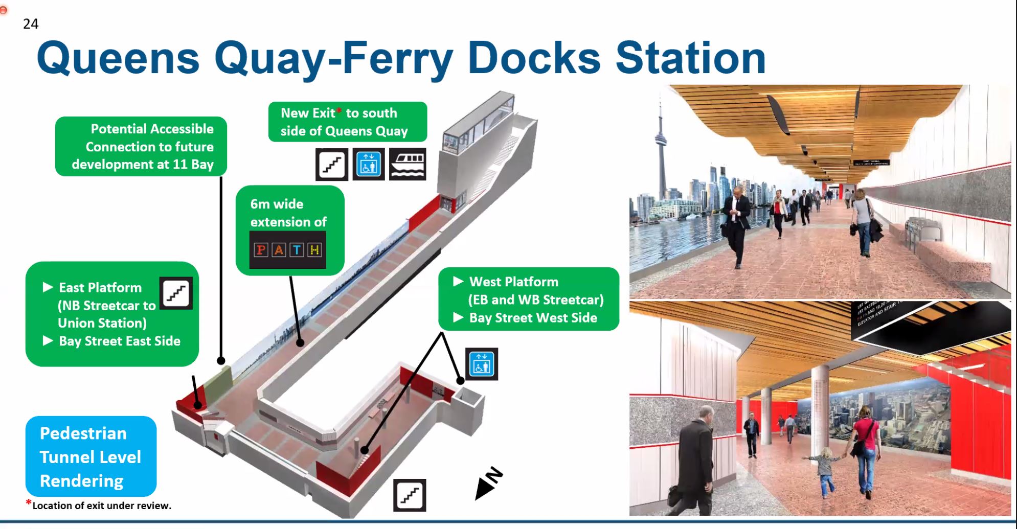
Escalators might be included at some but probably not all locations, notably by going out from the tunnel to the east into the basement of a new building on the northeast corner, or to the hotel on the southwest corner of Bay and Queens Quay.
Portals and Yonge Street Crossing
In the original plan for the Waterfront East line, the portal was located east of Yonge at Freeland Street. However, this would have required the tunnel to first dive under a large sewer at Yonge Street that cannot be moved. Surfacing west of Yonge avoids this. However, that space is now occupied by the very unfriendly, auto-oriented entrance to the Harbour Castle Hotel.
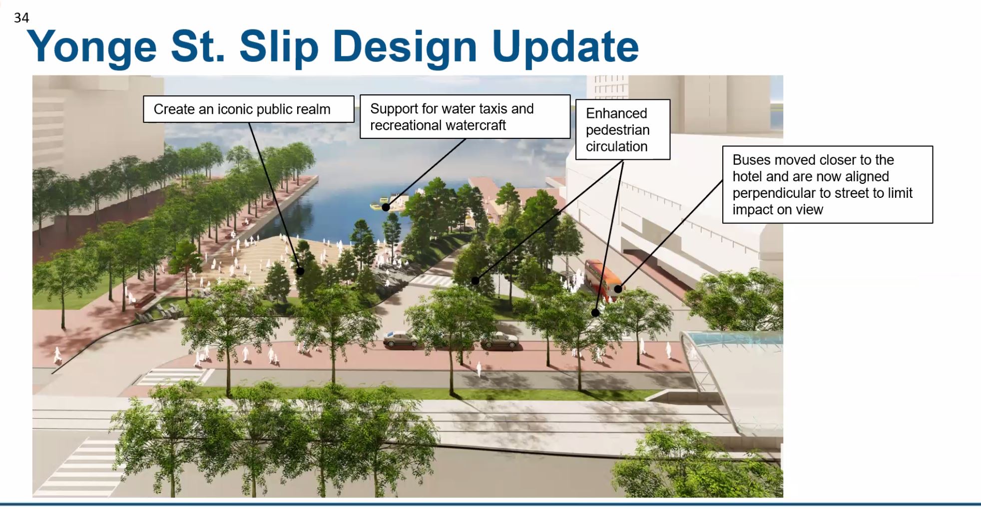
The shift to west of Yonge became the “technically preferred option”, and the plan now includes a redesign of the hotel entrance to face east onto a new plaza that will be created by filling the north end of Yonge Street Slip. The design includes both a loop for circulation of autos and buses past the hotel entrance, as well as access south to the Ferry Docks.

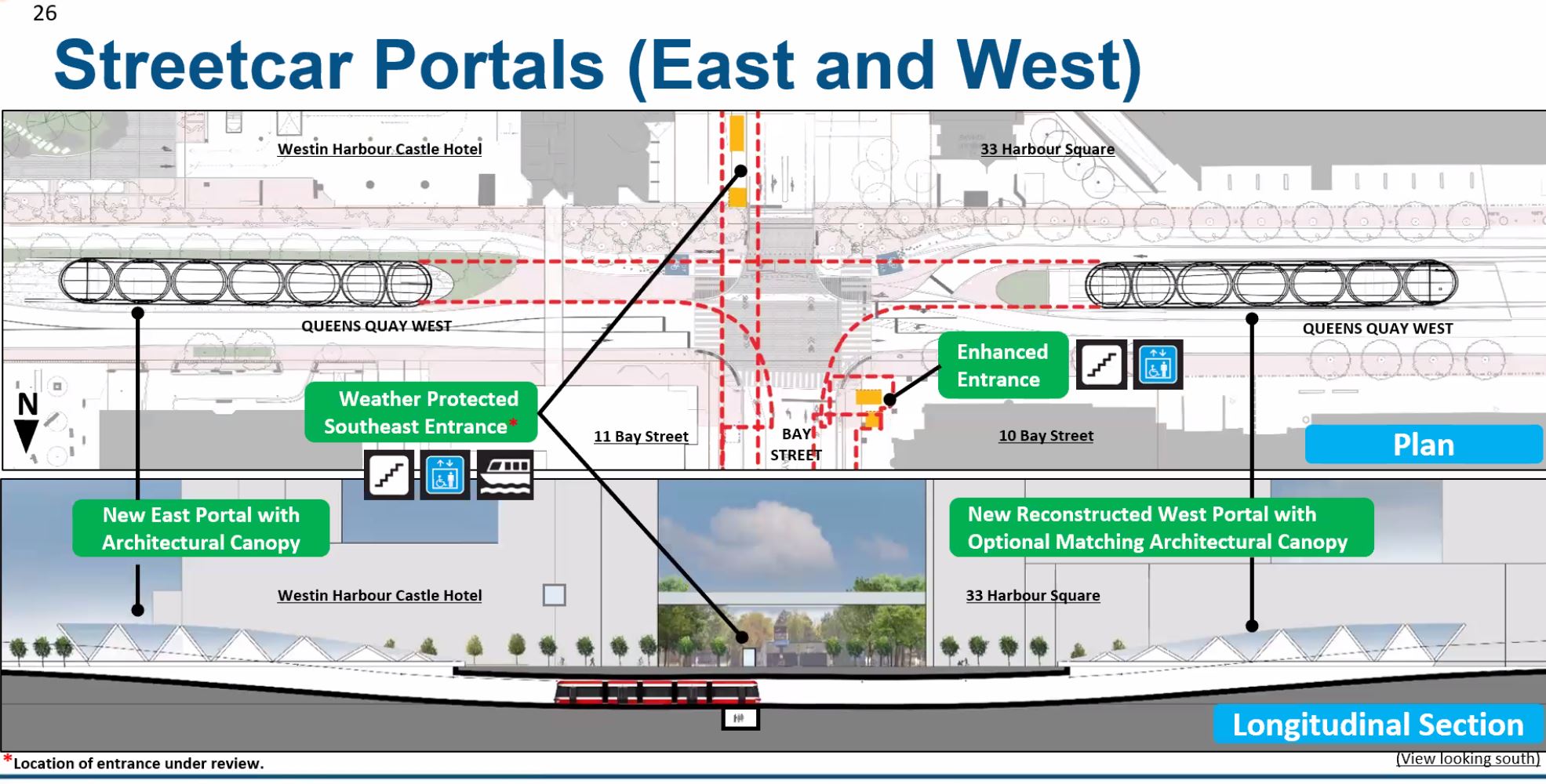
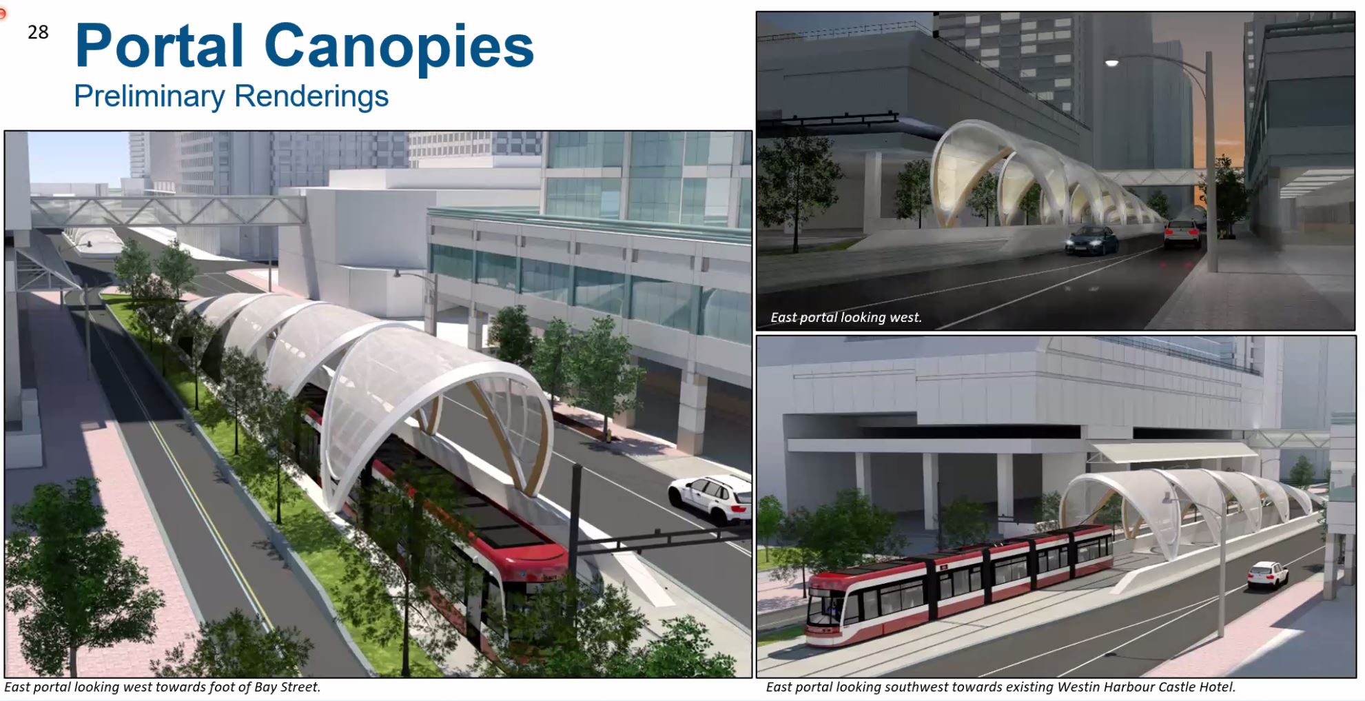
The new portal will have a more attractive architectural treatment than the plain western portal today. The project will add a new matching cover to the west portal.
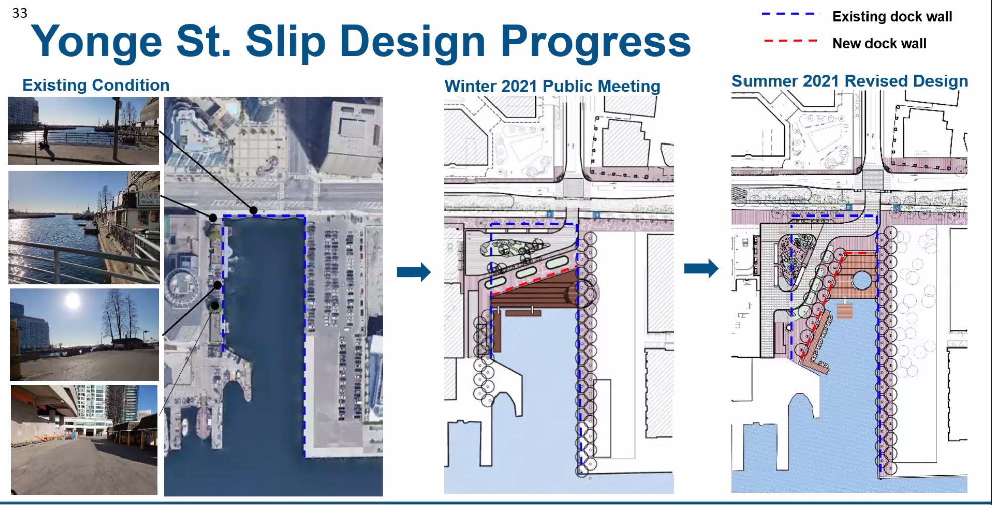
At the Yonge Street Slip, the design presented in the previous consultation was constrained for space, and this has been opened up. The bus stopping area has been shifted to the north-south direction in front of the new hotel entrance.
Through Service on Queens Quay
In April 2019, Toronto Council directed staff:
… to consider in conjunction with the preliminary design and engineering phase of the Union Station-Queen’s Quay link and East Bayfront extension, a phasing option that would implement a through streetcar service on Queen’s Quay to East Bayfront, in advance of the Union Station construction and implementation phase.
The Waterfront East project now focuses on staging so that a continuous service on Queens Quay and south into the Port Lands can be provided while the Bay Street tunnel and stations are rebuilt. This means that almost all of the eastern leg will be built and close to ready for service before demolition of the existing connection at Bay Street begins so that a switchover can be fairly quick.
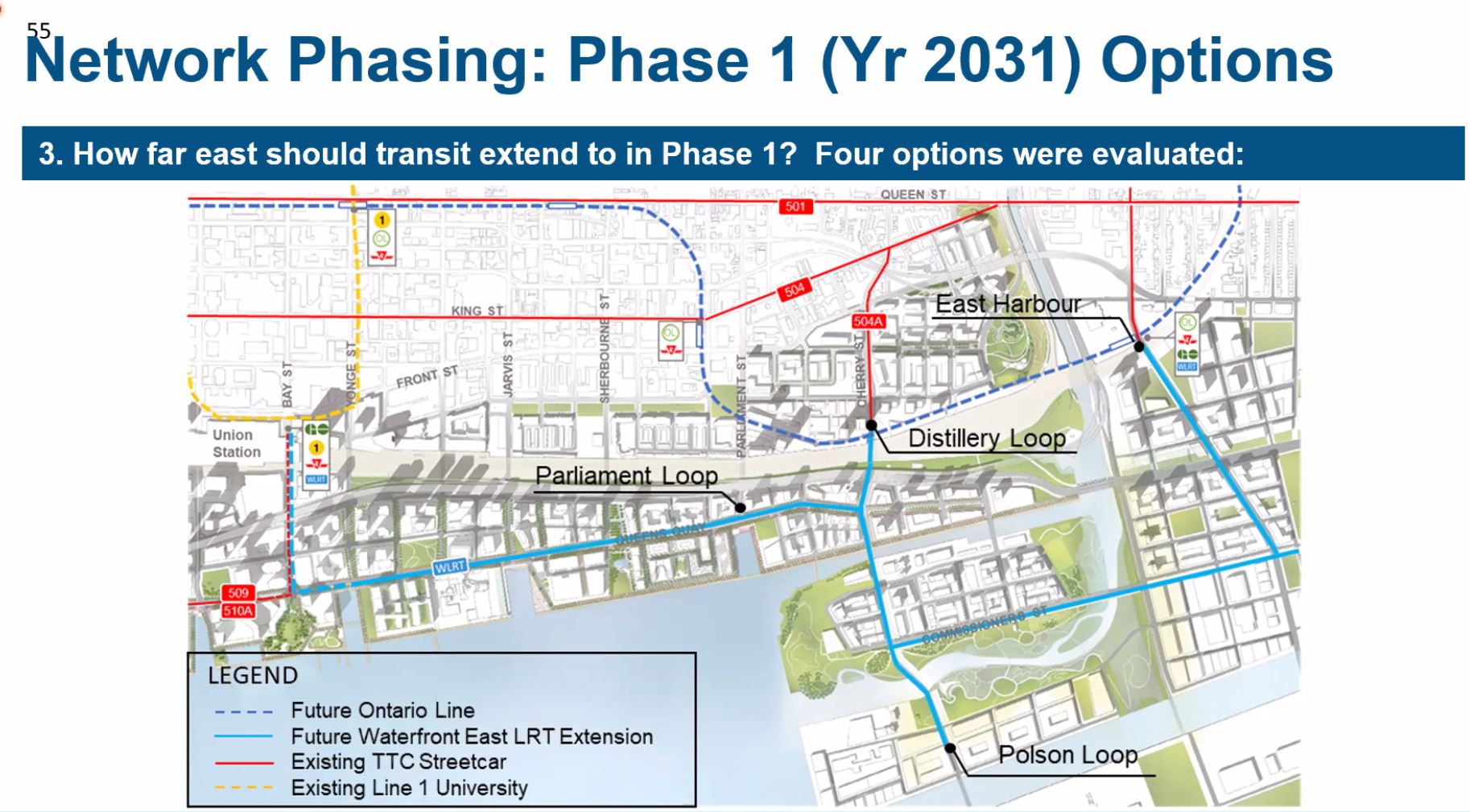
Various alternative termini were considered for this line including the original plan near Parliament Street, the existing Distillery Loop on Cherry, a new loop at the north edge of the Ship Channel at Polson Street, and East Harbour Station on the GO/Ontario lines.
Three of the four have problems that rule them out, especially for a fairly quick completion:
- The Parliament Street site is no longer available due to development.
- Distillery Loop requires a connection under the railway that adds to the complexity and time needed to make the line operational (see discussion of this link later in the article).
- East Harbour Station and the related Broadview streetcar extension will not necessarily occur in the required time frame.
- The Polson Street Loop can be built, with the only caveat being the need for an LRT bridge over the realigned Don River. Originally, this was not in the plan because the LRT would not extend south of the Don River, and so this adds one new bridge to the collection.
Design of Queens Quay East
The general design for Queens Quay East will mimic the layout west of Bay Street, but with stronger demarcation of the cycling and pedestrian realms including at intersections to reduce conflicts.
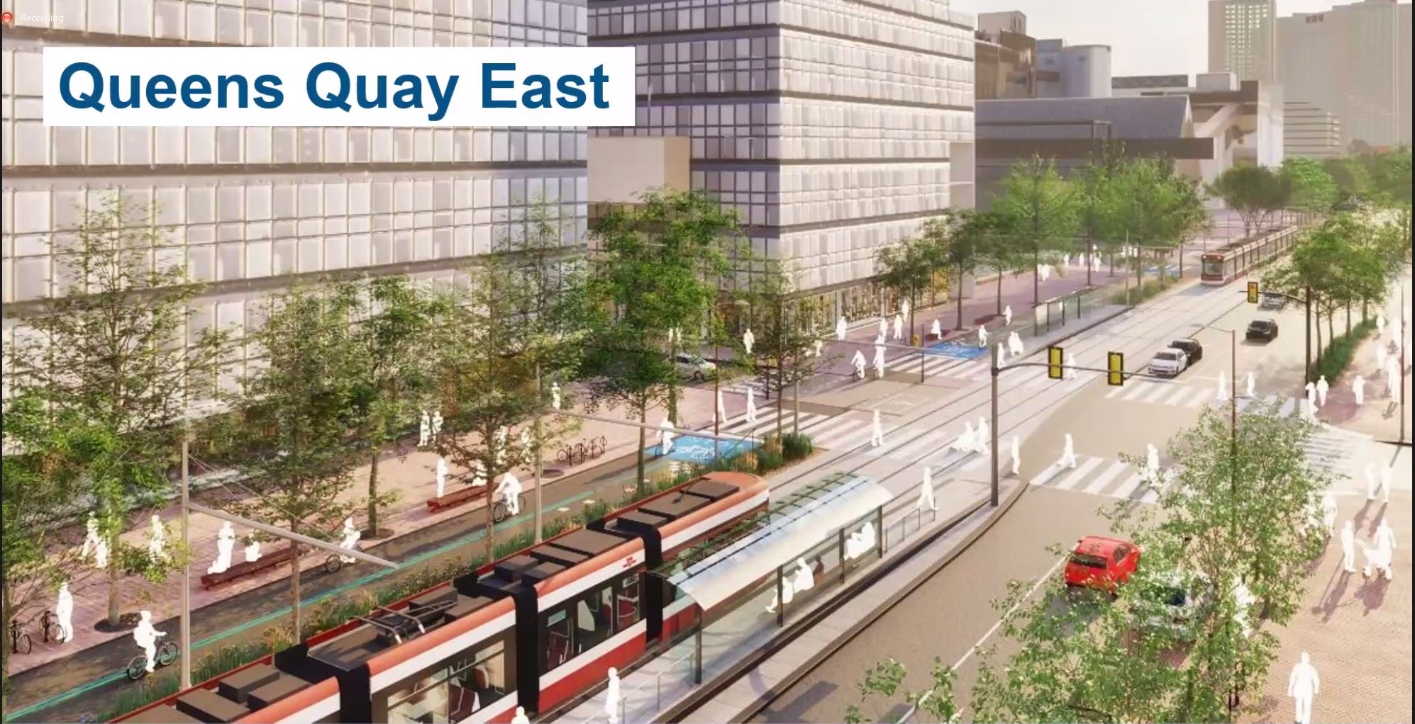
An important change in the design of cycling and pedestrian areas will be to provide clear separation between them.
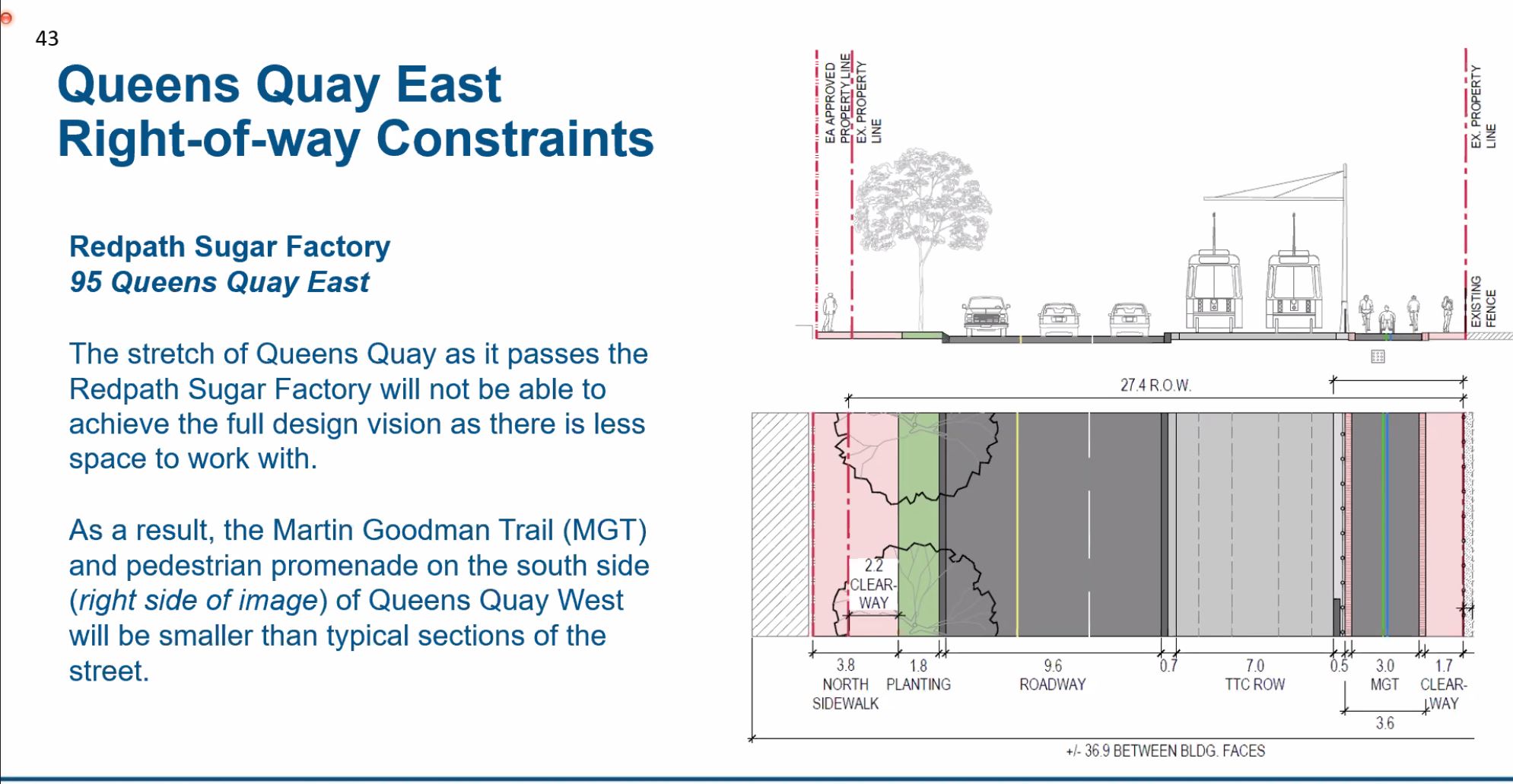
There is one area, north of Redpath Sugar, where the existing right-of-way is too narrow to fit in the standard design, and it will be a pinch point on the south side as shown below. Although the pedestrian and cycling areas are narrowed, this design protects for the possibility that the Redpath site might be redeveloped. If this were to occur, the area south of the street would open up.
If the cycling and pedestrian areas were widened with Redpath still in place, the streetcar track would have to shift north along with adjacent traffic lanes. This would be an interim configuration, and the tracks would have to be shifted back to their planned location if Redpath decamps from the waterfront.
Parliament, Cherry Street and Distillery Loop
The layout at Parliament Street will change substantially because Queens Quay, instead of swinging north to Lake Shore Boulevard, will continue straight east past the north side of the silos to the intersection with New Cherry and eventually to meet Lake Shore as it curves south to cross the Don River north of the Keating Channel.
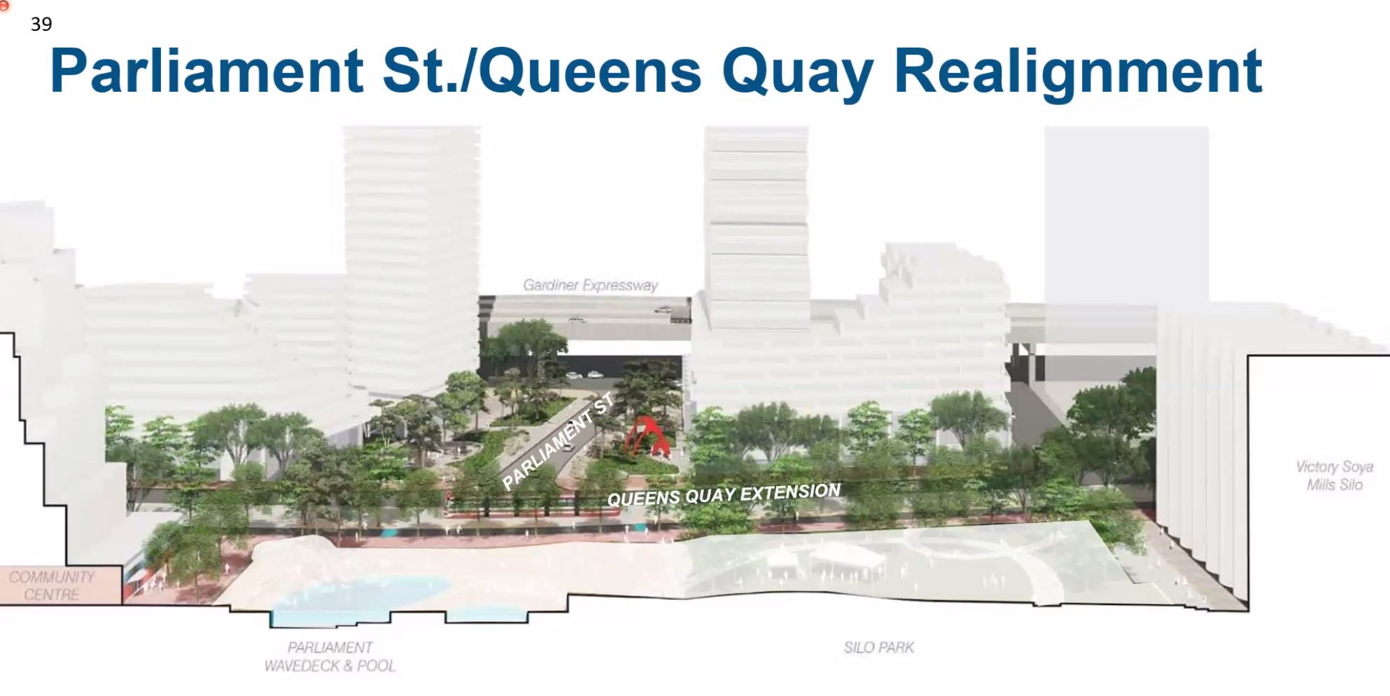
The road layout in this part of the waterfront will change quite a bit in the coming decade. Not only will the Gardiner Expressway link to the DVP be realigned and rebuilt, the complex intersection at Cherry and Lake Shore will be simplified.
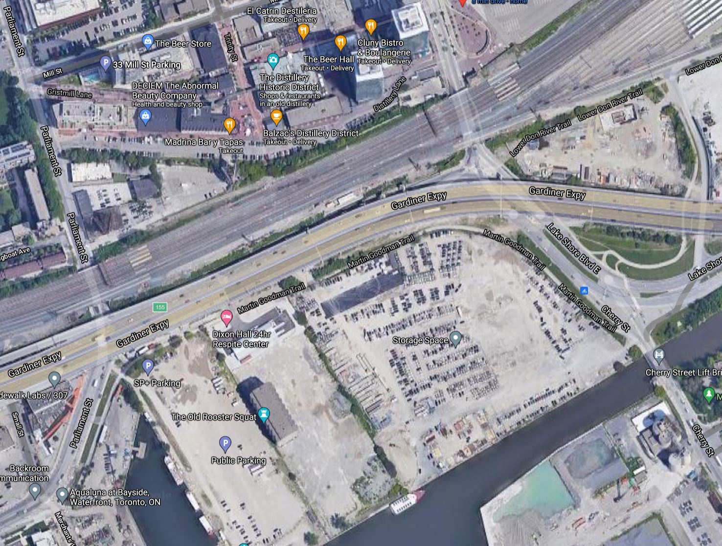
The image below shows the area as it was about a year ago. Queens Quay turns into Parliament Street at the foot of Small Street at the lower left of the image. The realigned street will head east across the north end of the slip, past the silos and over to meet a realigned Cherry Street.
The route of New Cherry is visible in the area that has been cleared north and south of the Keating Channel, and the new LRT bridge has already been installed (although not in this photo). When New Cherry Street is complete, the existing bridge to “Old” Cherry will be removed, and traffic will swing over to the new street.
Still to come is the New Cherry road bridge (the span is already sitting in the harbour awaiting installation), and two more bridges (one for LRT, one for road) where Cherry will cross the new channel for the Don River (out of frame below this photo).
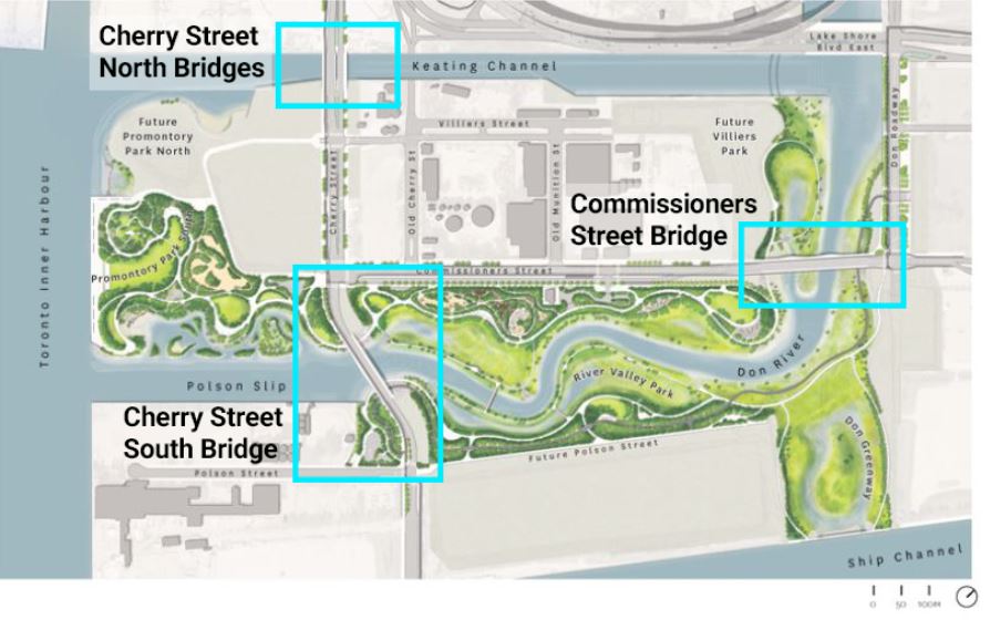
The new alignment and bridge locations are shown below. Note that the crossing at Polson Slip and the new river channel was originally designed for a single span because the loop was to be at Cherry and Commissioners. With the loop now south of Polson, an LRT span will be required at the Cherry Street South Bridge as at the North Bridge.
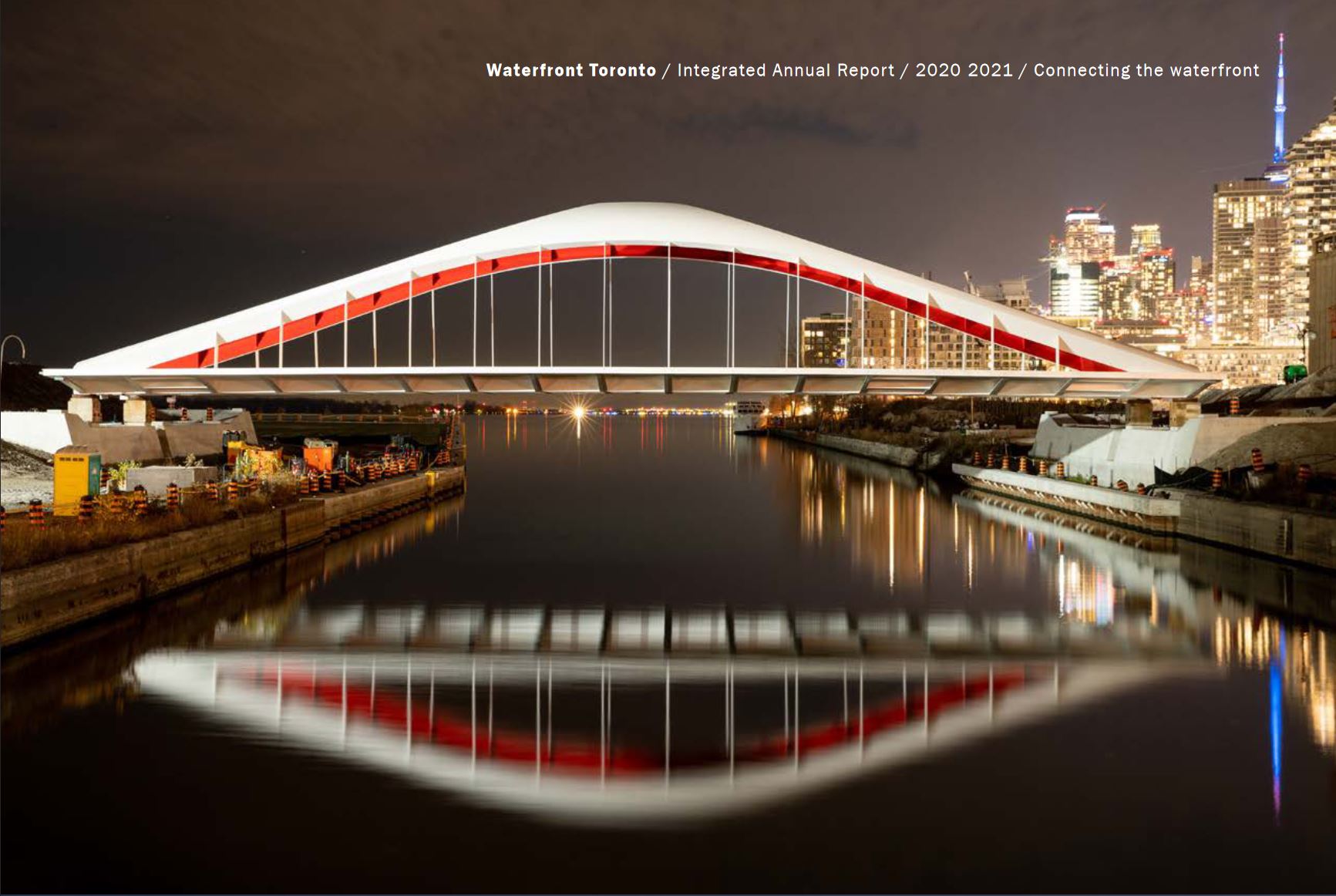
The LRT span for New Cherry has already been installed. I could not resist including this image of it taken from Waterfront Toronto’s Annual Report. A companion road bridge will sit beside this. Yes. This is a bridge for streetcars.
When the Cherry Street LRT was in the design phase, there was some discussion of how to get under the railway and connect with a future line on Queens Quay. Four options were considered.
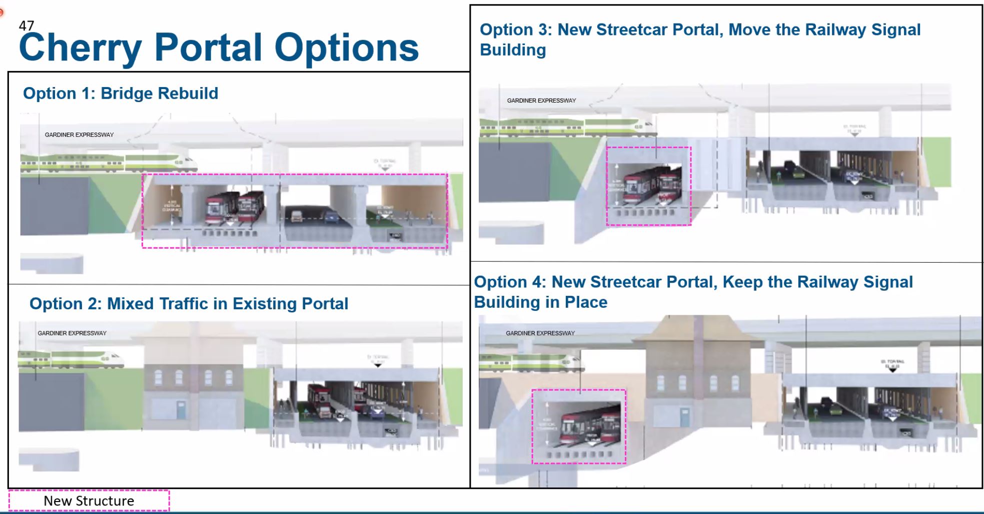
- Rebuild the existing Cherry Street bridge/underpass with additional portals to make room for the LRT.
- Operate the LRT in mixed traffic through the existing underpass.
- Build a new portal for the LRT that would connect to Distillery Loop through the current location of the Cherry Street Signal Tower (now decommissioned).
- Build a new portal for the LRT east of the Cherry Street Tower.
Options 1 and 2 were ruled out. The first would require replacement of the bridge deck under an operating rail corridor. The second would require Cherry Street to be lowered to provide clearance for streetcars under the existing bridge, and would also make a pinch point for operations where streetcars were forced into a narrow space with other traffic.
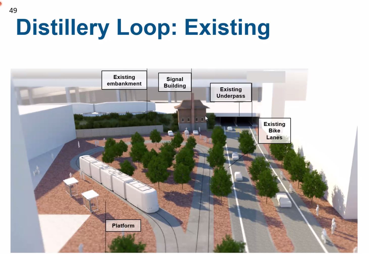
Distillery Loop looks roughly like this today.
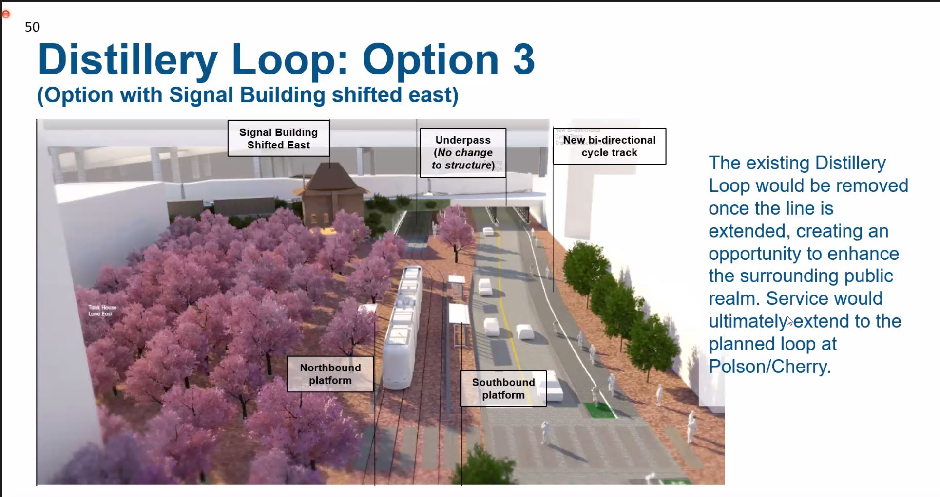
Here is an image of what Option 3 might look like.
At one point Metrolinx contemplated moving the signal tower somewhere nearby for preservation, but option 4 eliminates the need for this.
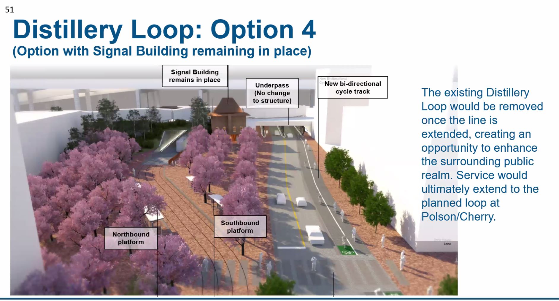
The new underpass would connect in to the east side of Distillery Loop. Note that there is a grade change required to get under the rail corridor, and that Distillery Loop itself would disappear.
An issue to be worked out is the design of the intersection south of the rail corridor where the streetcars and other traffic will emerge at different locations rather than side-by-side.
At this point, the Ontario Line will pass under Cherry at a depth of at least six metres and will be climbing from its deep underground alignment at Corktown Station to emerge west of the Don River just north of the rail corridor. There are no plans for an OL station at Cherry.
Next Steps
Future public engagement topics will include:
- Bay Street redesign
- Phasing and Implementation update
- Design of the Cherry Street link to the Distillery District
- Summary of Benefits Case
- Key project impacts and mitigations in EPR
At the political level:
- July 6, 2021: Executive Committee will receive an update on various transit projects, but this will not include the Waterfront East nor the Eglinton East LRTs.
- October 27, 2021: 30% Design Report for Waterfront East submitted to Executive Committee, then to Council on November 9 for direction about funding in future capital budgets.
Assuming Council approves a budget, detailed design would begin in 2022 with construction likely from 2024 to 2029/30. Among the first steps will be the Yonge Street Slip filling and reorientation of the hotel entrance because construction of the east portal cannot begin without it. A transition plan will be needed to “flip” operation of the Queens Quay LRT from turning north on bay to running through to the eastern extension in as short a time as possible to minimize the period of bus substitution. There is probably 2-3 years of construction on the east side of the line before the “flip” could occur.
The connection to the Distillery District will be designed to the 30 per cent level including an Environmental Project Report (EPR) so that the project is ready to go if funding for that stage materializes. It is, however, a “longer term” element according to City staff.
Some parts of the overall approved waterfront plan, such as the “Bremner streetcar” are also further out, although the City is still protecting for their eventual construction.
The connection to Leslie Barns via Commissioners is not expected to be built until about 2041.

I am amazed that you completed this article with so many exhibits within an hour of the online meeting completing. I think you managed the same feat after the Ontario Line meeting.
Since connecting the Waterfront East LRT to Distillery Loop would have eliminated the loop itself, where would the new line have terminated in the previous iteration before deciding to terminate at Polson Loop?
Steve: In both cases, I started to write the articles mid-afternoon leaving spaces for the illustrations. Some of the info was already available elsewhere on the Metrolinx site from earlier posts. On the Waterfront, I am on the SAC for that project and saw an earlier version of the presentation a week ago. Yes there were changes in the intervening time, but I was able to write an outline and simply drop in the illustrations from tonight’s deck as they went along.
It’s not magic although it may seem like that. The working press do this sort of thing all of the time by pre-writing articles, or at least the skeleton of pieces that can be quickly fleshed out when the material becomes public.
Re Polson Loop: That was new in this round at the SAC, and of course tonight. It is an intriguing change and brings direct transit service further south than was originally planned. Although it was not mentioned tonight, they had already flagged the need for an LRT span for the Cherry Street South crossing of the river. Previously the southern terminus would have been at Cherry and Commissioners. I suspect that something has stimulated their interest in building further south than they planned.
LikeLike
Either they hate the green colour of grass, or they assume the grass they will be using will turn brown from the summer heat. Mostly, it seems they are using Toronto “grey” for the right-of-way.
LikeLike
Thinking TTC is missing a trick here. They can potentially decongest union station significantly and expand service to south core by extending the U down to the harbourfront. Add stations under Station st (west side access to Union GO), Bremner blvd, Harbourfront/south core, Esplanade (east side access to Union GO). Retain the existing U as stabling/storage area. Keep streetcars above ground along Queens Quay and connect to the subway the harbourfront/south core station. No need for the loop reconstruction.
Steve: Extending the “U” would break the subway connection to Union railway station. Also it would require building a subway through the filled land below the water table. This might have been possible decades ago before South Core developed and there was some flexibility in construction, but the area is now full of condos and office buildings.
LikeLike
An excellent job, Steve, of summarizing a complex situation. A couple of questions arise; will the TTC “miss” Distillery Loop from an operational standpoint, for short turning 504 (KING) cars? You’ll recall that, a few years ago, there were plans to restore the former Parliament/King streetcar loop for short turns and, when this idea was dropped, build a new loop on the city parking lot on the east side of Broadview, just north of Queen. This was not pursued, presumably because of the planned Distillery Loop; secondly, why is Cherry Street being realigned, undoubtedly at considerable expense, particularly the new bridges? Could not the present configuration be retained, with the existing bridges used for the streetcars? Lastly, is development presently underway in this area (Cherry Street), or at least definite? I haven’t been down in that area for a long time.
Steve: I have only rarely seen King cars short turn at Distillery Loop. The Parliament/Dundas/Broadview loop still seems to be the preferred option. As for the loop at Queen and Broadview, I wouldn’t hold my breath for this either, although the TTC now owns the parking lot in question after a complex land swap with the Parking Authority.
As for Cherry Street, this realignment was planned years ago as part of the master plan for the Port Lands and the realignment of the Don River. Where have you been? This plan is at least a decade old.
The existing lift bridge on Old Cherry is on its last legs and would need to be replaced no matter what. Realigning Cherry allows the reconfiguration of complex intersections north of Keating Channel, and the insertion of new bridges for traffic and transit. With the new river and the creation of Villiers Island, New Cherry can be built as the main north-south street of this district.
As for development, there are many buildings underway and occupied along Queens Quay, and developers are chomping at the bit to build around the new river. I recommend a visit to Waterfront Toronto’s website.
This project is very, very much underway as you can see in constuction update photos in the Waterfront Toronto Board meeting report starting at page 33. Also in that file is their draft Annual Report starting at page 109 which gives a sense of what is going on in the Eastern Waterfront.
The point at which one might ask “why new bridges” passed a long time ago.
LikeLike
Has there been much thought to how routes would work during the phase when union loop is closed and when it is complete?
During the phase when the loop is closed and only through service is available they should build a temporary stop west of Bay, otherwise there would be a huge gap between stops and that location is right in front of an entrance to the PATH to allow people to walk downtown without taking the streetcar the long way around.
Steve: I suspect we will see that in the next round of design work.
LikeLike
It’s great to see – maybe the Portlands (unlike East Bayfront) will be a ‘transit first’ neighbourhood after all!
With the expensive bits completed by the 2030s, further extensions to Broadview and Commissioners will be easier to get funding for given they are simpler projects and have a lower cost…
Steve: Unless some descendant of the Ford crew seizes control of transit right down to the colour of the benches at local bus stops and screws up the plans again.
LikeLiked by 1 person
An interesting observation from your excellent post is that the streetcar-only Cherry Street bridge will not likely be used for nearly ten years, until 2029- 2030! Have I understood that correctly?
Steve: That is correct! Thanks to all the politicians for whom everywhere but the waterfront “deserved” transit investment. Mind you, as the LRT bridge is east of the road bridge, it’s a lot easier to install it first. Who knows, the TTC may run the half-hourly Cherry Street and now-and-then Pape buses over it in the interim. Of course the roads leading to it won’t be done for a few years yet. Meanwhile it is a beautiful bridge!
LikeLiked by 1 person
Steve, do you know if tracks have been laid on this Cherry St. bridge? If not, what kind of surface does the deck have? I would assume a material that may be easily removed.
Steve: No tracks. At one point there was a scheme to run buses in the transit lanes as a short term measure. I will ask Waterfront Toronto if I can get details of the bridge design.
LikeLiked by 1 person
Why does the connection to Leslie Barns along Commissioners happen so late?
I’ve always assumed new tracks would be part of rebuilding Commissioners Street after the earthworks, so mid-2020s. Are they doing the Cherry to Don stretch then, with the Don-Carlaw-Leslie stretch as a separate project?
Steve: The pre-requisite for the link to Leslie is the East Harbour project including the streetcar connection to Broadview via Commissioners which would be at the earliest around 2030 given the timing of the Ontario Line. Why it would take another decade to run over to Leslie, I don’t know, but suspect it is not as high priority as, say the western extension from Dufferin, and even that is not exactly at the top of the list.
LikeLike
According to the presentation:
I can see the 19 BAY bus (the 6 BAY bus in a previous life) become an infrequent “shuttle” bus serving Harbourfront Centre and Yonge Streets stops. May need a more frequent “shuttle” bus, looping between Queens Quay and Union Station.
Steve: The real problem in all of this will be traffic congestion on the roads that remain open. I suspect that 19 Bay will end at Front Street and there will be a separate shuttle. It’s going to be messy, and without that Cherry Street link, a loop service via King, Spadina, Queens Quay, Cherry is impossible.
LikeLike
Steve, do you know if the TTC has the space for additional streetcars to provide the expanded service, or will the Hillcrest expansion free up space at Leslie to accommodate?
Steve: Leslie has some space, but the Hillcrest expansion is needed to hold the remainder of the 60 cars recently ordered. After that, another carhouse or storage yard somewhere would be neededif the TTC wanted additional cars.
LikeLike
I am a little worried that the wye from Queen’s Quay to Union Station seems to be at the bottom of two inclines. This strikes me as a collision in the making.
Am I missing something?
Steve: The junction will almost certainly have a traffic signal, although I hope it is more intelligent than the one at St. Clair West Station that simply cycles back and forth regardless of where there is a waiting vehicle.
If it’s a runaway car you are thinking about, we have never had one in the years St. Clair West and Queens Quay stations have been open. That doesn’t mean it could not happen, but there is a point where you have to trust the technology.
LikeLike
I feel like this is finally a fairly solid plan given the silliness we have seen on this file with path connections and moving walkways and Rob Ford and all the other things it has gone through…congratulations to whoever they hired to do this work…job well done…lets build it, before Doug builds his Ferris wheel on that beautiful bridge and sends everything back to square one…
Steve: As someone who has sat on advisory committees for the waterfront and attended more meetings than I can count, the frustration at how long all this is taking to achieve is immense. Plans we hopes to see running already lie unfulfilled while billions go to buy votes elsewhere. To their great credit, and probably because they report to all three governments, Waterfront Toronto has beavered ahead with the massive reconstruction of the Don River, but the transit plans are not part of their base funding. They can build in provision for future streetcar lines, but actually implementing that network is up to the City and its funding partners. Meanwhile developers who were told that this would be a “transit first community” grow frustrated waiting for service to arrive.
LikeLiked by 1 person
Queens Quay East will be a hive of activity on the basis of Nigel’s comment that the Queens Quay East-West streetcar will start construction in 2024-2025. There are perhaps 3 or 4 major condo projects that will also be starting or started around Yonge Street at that time. It’s gonna be busy!
LikeLike
I still have the original marketing material from 2012 explicitly showing a streetcar passing in front of our building. As a bit of an alternative, it’s good that we have 3 buses pass in front of our condo. Mostly we take the 6 (soon to be 19) Bay to Union.
Greenland (215 Lakeshore and Richardson) has Phase 1 approved and Phase 2 will most likely go back to the drawing board. When completed, these two new towers and appurtenant buildings will add over 3,000 residents and over 1,200 cars to the area. Transit can’t happen soon enough.
LikeLike
I spend a lot of time on Cherry St south of Polson St. and there is a lot of foot and bike traffic in warm weather, especially on weekends. I’ve noticed it considerably increasing over the last 5 years. Having transit service that goes further south than Commissioners I think will really help.
If a Polson loop is built, Steve what do you think the plan for it would be once the East Harbour link is complete? Will Union-Polson service only happen until then, or maybe it will be a branch of the waterfront LRT, and I guess potentially a new terminus for the Cherry streetcar?
A related question, do you know if the huge The Docks/Rebel entertainment complex will be sticking around when the Portlands project is complete? That place is a zoo on hot weekends and clogged with Ubers and potentially inebriated drivers. A Polson loop at its doorstep would solve a lot of problems, while also being a boon for their business.
Steve: With the opening almost a decade away, one could speculate a lot about how things will operate then, let alone when other parts of the waterfront network are built. A lot will depend on when he links to the Distillery District and to East Harbour / Broadview Extension materalize. For example, with Broadview open, a service to the Danforth subway would be possible that also connected to the Ontario Line.
Will The Docks still be there? Who knows? It would be a great condo site, much improved with a streetcar loop just down the road.
LikeLike
The fact that Union Station expansion has taken this long is because many of those involved kept believing that there must be a cheaper, less complex alternative. And rather than just get on with it, there had to be yet another study done of something that has been studied to death over the last 20 years. Each additional study cost both time and money while offering little of additional value, as we’ve ended up with a design that very much resembles what was first proposed a couple of decades ago. Nevertheless, I am glad to see that we are finally progressing with the correct option for Union Station. I also hope that the upcoming funding decisions of Council will recognize the urgency that waterfront transit deserves, but lost with the election of the Mayors Ford in 2010.
LikeLike
That the project has moved to the point that we have a full delta junction at Queens Quay (and a link to the ferry dock!), the hotel’s palm has been crossed with public spend silver to free up their street front, there is an explicit goal of minimizing the length of shutdown of streetcar service on the western waterfront by doing a reasonable quick cutover to run through service while Bay Tunnel-side works progress, it seems a shame to complain.
BUT. (This is a comments section after all)
My understanding is that several years ago the City intended to acquire lands for a Parliament Loop. Did that transaction not complete? At least as recently as April 2019 and the Union – East Bayfront IBC, the Parliament loop was very much in play, so surely at that time it was thought there was enough space to build it. It is confusing to learn now that somehow those lands have been either directly made the subject of development plans or that adjacent development plans have progressed, to the point where a loop is ruled out.
Steve: The Small Street Loop property is owned by the City, but plans for the area make it a poor location for a “temporary” loop.
Now the only options to restore service if the track or power south of Keating Channel goes OOS is to run Distillery cars to Spadina loop or Union, and Queens Quay cars north to King and some sort of on street wander back down to King and Sumach. A loop east of Cherry/Queens Quay seems the obvious alternative but one gets the feeling that that would upset some other WT/developer play.
A lot of track is being added but to only build Polson and delete Distillery is essentially adding net zero turnaround capacity… unless there is some notion to building non revenue track along Parliament to King? If only Metrolinx were jacking up that bridge rather than the ones further east.
I can’t say I care for the new “solution” for Cherry Tower either, which I had understood to be moving about half way to Corktown Common. Instead of relocating a redundant although notable structure, the track is to be skewed (presumably with some added noise as streetcars turn into/out of it) and must pass under the rail structure at a point where the rail deck widens sharply as it progresses east, resulting in a longer portal. One hopes this isn’t merely a lazy way of addressing a dispute with Metrolinx about how tower relocation costs are allocated and which costs are actually necessary to incur.
Steve: Yes, at one time Metrolinx was going to move Cherry Tower, but they are avoiding spending wherever they can (have to pay for those billions in LRT, oops, no, subway projects somehow). My sense is that the City planners would like to see the Distillery connection go forward as soon as possible, but the question is where the money will come from. They want to get it to 30% design so that if a more favourable government is in place, money can flow quickly.
There is a lot of pressure from developers in the waterfront to get the line built, and the Polson option gets things rolling.
LikeLike
Hello Steve,
I don’t know if you’re aware but the abandoned Google head office site that was slated for this area might house a new Blue Jays ballpark. My sources tell me the Jays prefer this site for a future 45,000 seat open air ballpark with real grass since Google pulled out. Transit will connect with the ballpark from Queens Quay, Cherry and Broadview LRT, 5 years from now, with the realignment of the Gardiner expressway coinciding with this project. A new hotel is also planned along with the housing developments planned.
This ballpark will attract tourists to the area and help with other developments planned like outdoor patios cafes and a few sports bars. I believe that’s why a Polson loop has come into play, keep your eyes and ears open, we will hear more soon. There will be no taxpayers’ money involved, the naming rights will be sold for this new park and a land swap will occur with the present Rogers Center reverting back to the city for redevelopment. The Jays budgeted $400 million to reno Rogers Center but estimates quoted are close to $700. A new ballpark similar to the NY Mets new ballpark will cost $900 million. It will also incorporate the look of old Maple Leaf Stadium that existed on Bathurst at Queens Quay years ago!!
Steve: Interesting, although there are a few problems with the dates. First, another nearby transit line would be Corktown Station on the Ontario line that is a short walk up Parliament, but it won’t open until 2030, if then. The Queens Quay line similarly will not exist until 2030, at least with a connection to Union, possibly sooner for an east-west service across the waterfront. There is also the problem of making the connection to Distillery Loop. The Broadview LRT is similarly way off in the future, 2030 at best, probably further if one includes the link west via Commissioners Street to Cherry.
It would take a massive upheaval in funding, construction timing (some of which is beyond the point it can be advanced) and general waterfront policy for this scheme to go forward.
LikeLike
Has the previous proposal for a 60m platform under the rail corridor with another 60m platform adjacent to 45 Bay been shelved permanently?
Steve: The only platforms are opposite each other for two 30m vehicles plus a crossover in each direction, and they are under the rail corridor. 45 Bay (the bus terminal) already has a link to Union, albeit roundabout, and there is provision for a knockout panel from 45 Bay into a link onto the northbound streetcar platform. I have never seen a design with a separate platform for 45 Bay.
LikeLike
It was in the early waterfront reset report (Waterfront Transit Reset Phase 1: Network Vision) and it looked pretty similar to the current but with both platforms on the northbound side extended to fit two cars. Total platform space: 6 cars (1+1+2+2).
At some point along the way the idea was dropped and it doesn’t look like it could be done in the future without more major pain. The space for 4 cars seems like an under build.
Steve: There is a point at which a long platform at Union becomes operationally very difficult because it assumes that many cars are in the station at once. Moreover, there is a problem of just where the cars stop, and the walking distances to/from the subway this would imply. Another issue that needs to be solved, at least as it affects capacity planning, is to decide once and for all about the Bremner streetcar connection. I have always regarded this as a very, very unlikely route because of the difficulty of threading it through the existing development where I do not believe the road space that has been “reserved” is anywhere near adequate.
LikeLike
The document is still available on the Waterfront Toronto site for now.
I do wonder if the negotiation took place and if the 45 Bay building design was modified to account for any future expansion. Knowing that the final version has dropped it for the time being, I have my doubts.
LikeLike