
Last June, I posted a long article about plans for the Waterfront East LRT and the designs as they were then proposed. See Waterfront East LRT: June 2021 Update.
Although the next full project update will not come to Toronto’s Executive Committee until the end of March 2022, a revised proposal for the treatment of Cherry Street was presented to Waterfront Toronto’s Design Review Panel on February 23. I have only included a selection of illustrations from the presentation deck in this article, and I recommend that interested readers browse the full set.
As described in the June 2021 update, the link from the existing Cherry Street trackage under the rail corridor to New Cherry Street will be made through a new tunnel through the rail berm east of the existing Cherry Street underpass. However, the original plans for the area involved a small forest of, yes, cherry trees and this has proved impractical. The water table is very high and the underpass is a low point in the surrounding terrain. Any high water event would flood the area.
The new design starts from the premise that the water should be controlled and included as part of the landscape with a marsh around the new transit corridor as the proposed solution.

The illustration above shows the area where Distillery Loop is today. The Cherry Street signal tower is a landmark that, in the proposed alignment, would be shifted east. An alternative scheme leaves the tower where it is and the streetcar tracks swing east around it.
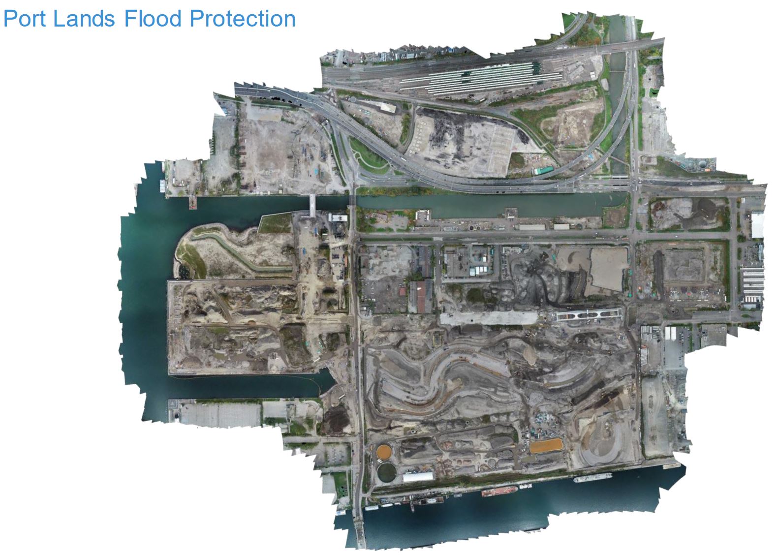
To put this in a wider context, here is a map of the overall waterfront area showing various projects. Only the area outlined in red is the subject of the current report.
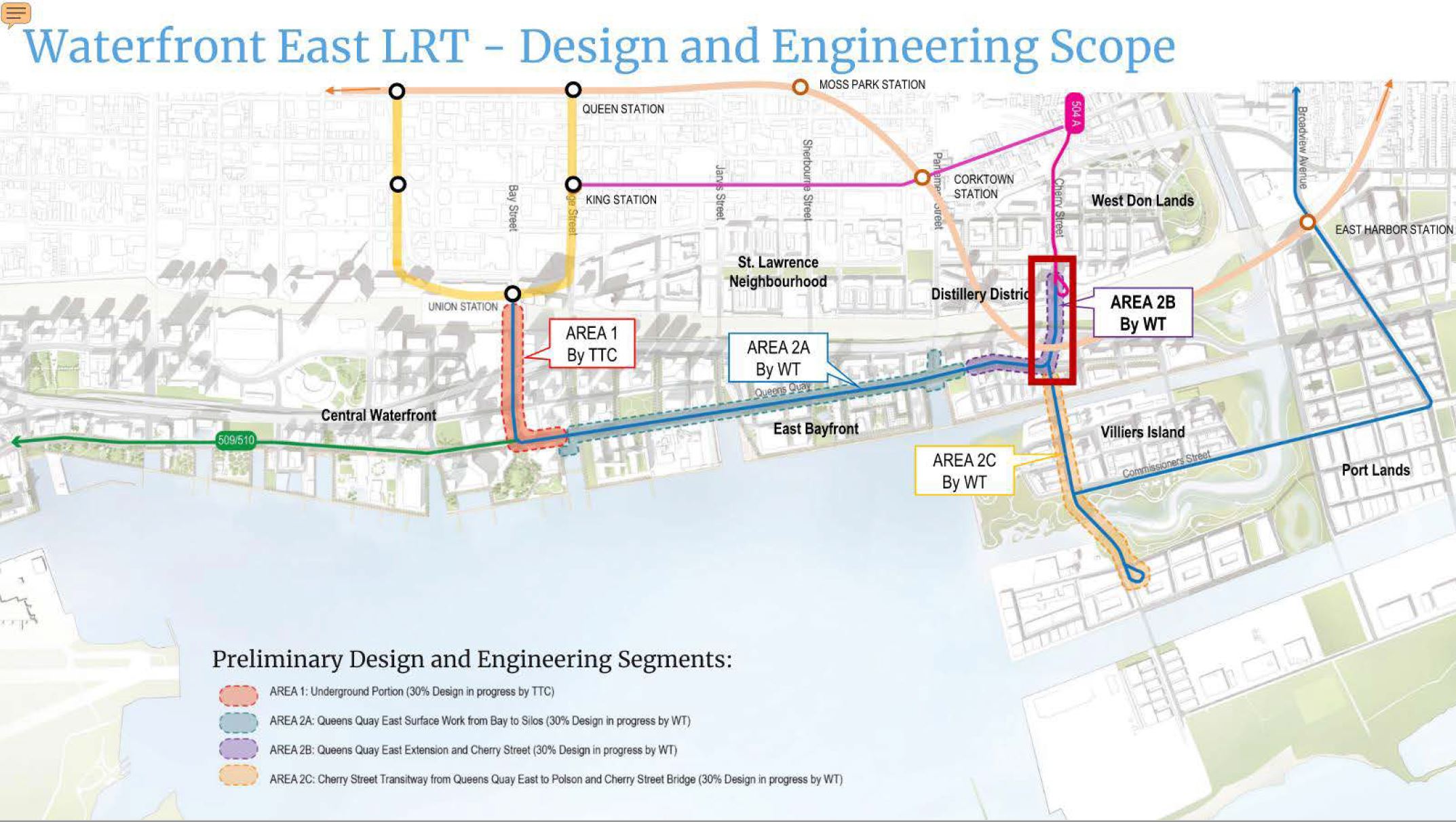
Construction has just begun on realignment of Cherry Street south of the rail corridor and replacement of the bridge carrying Lake Shore Boulevard across the Don River. Cherry Street is now closed at the rail corridor. When it reopens, it will connect to New Cherry Street and the new bridge over the Keating Channel to Villiers Island (which, strictly speaking, is not yet an island because the new river course has not yet been flooded).
Originally, the southern loop for Cherry Street trackage was to be on Villiers Island itself at Commissioners Street north of the new river. This has been changed, and the line will now run south almost to the Ship Channel at Polson Street to better serve development south of the river.
A future route would connect east on Commissioners to an extended Broadview Avenue and thence north to East Harbour Station on the Ontario Line. (This could be extended east to provide a direct link to Leslie Barns.) The route of the OL is shown as a salmon line coming east along Queen, dipping through Corktown and the Distillery District and then heading east across the Don River. The OL runs underground until just west of the river where it emerges from a portal to cross on a new bridge north of the existing railway.
For all three water crossings (Keating Channel, Don River at Cherry, Don River at Commissioners), the LRT line will have its own bridges twinned with separate road bridges. The Keating Channel transit bridge is already in place, and the road bridge will follow soon this Spring so that traffic can be switched to New Cherry Street. The new Commissioners Street road bridge is already in place, but sits high and dry over the still-under-construction new Don River channel.
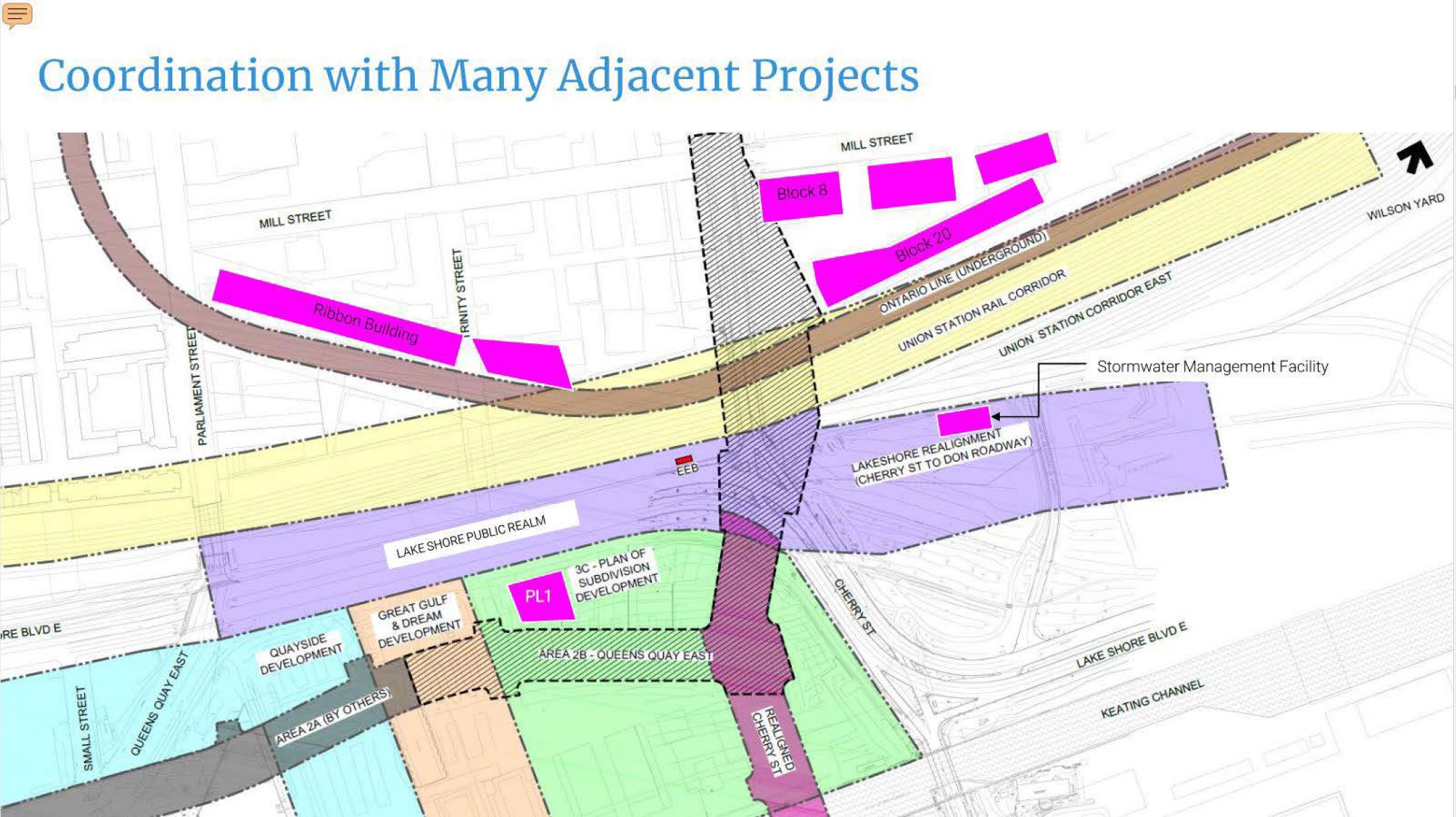
Today Queens Quay swings north to merge with Lake Shore at Parliament (left/west of this image), but it will be extended across the north end of Parliament Slip and across New Cherry Street. The existing street layout is shown on the map below along with many other projects in the area and the outlines of the new Cherry and Queens Quay rights-of-way.
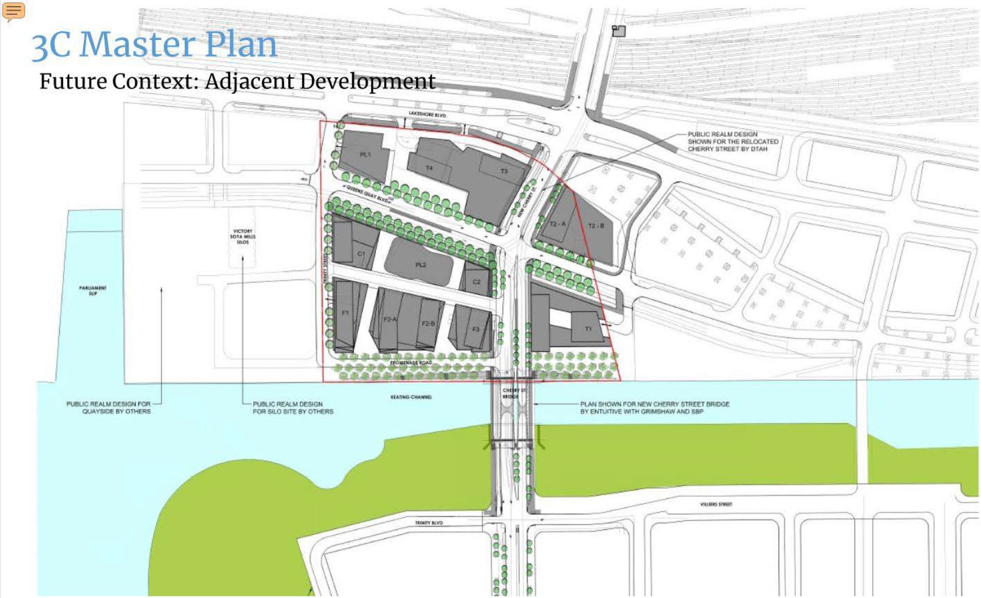
The plan below shows the “after” configuration where the existing Cherry Street bridge has been removed. Old Cherry is one block east of New Cherry on Villiers Island. The small light gray squares are the columns holding the rebuilt Gardiner Expressway which will turn north to connect to the Don Valley Parkway east (right) of this loctation.
The realignment of Cherry and Queens Quay East will be accompanied by substantial development on the north side of Keating Channel.
This is a complex area as a map of the major options below shows. Any new infrastructure must be threaded among a variety of roads, bridges and utilities.
The options are:
- Reconfigure the existing Cherry Street underpass and finesse the LRT line into that structure (mauve). This option was discarded some time ago because there simply is not enough room for transit, road lanes, cycling and pedestrians.
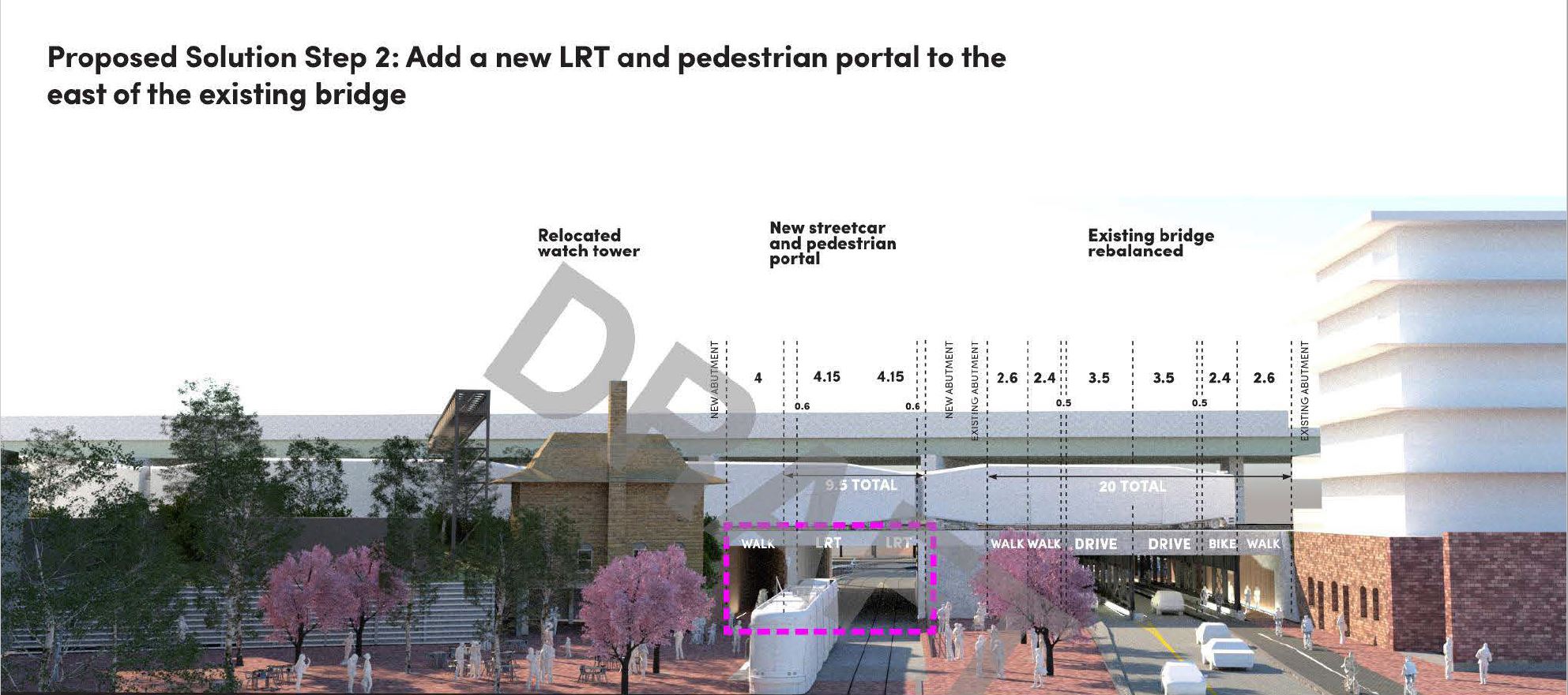
- Continue the LRT on its existing alignment straight south (red) through a new underpass. This would require relocation of the Cherry Street signal tower.
- Dodge the LRT east through the middle of what is now Distillery Loop and through a new underpass just east of the tower (blue).
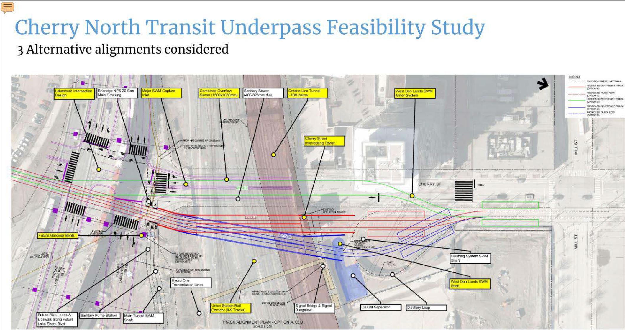
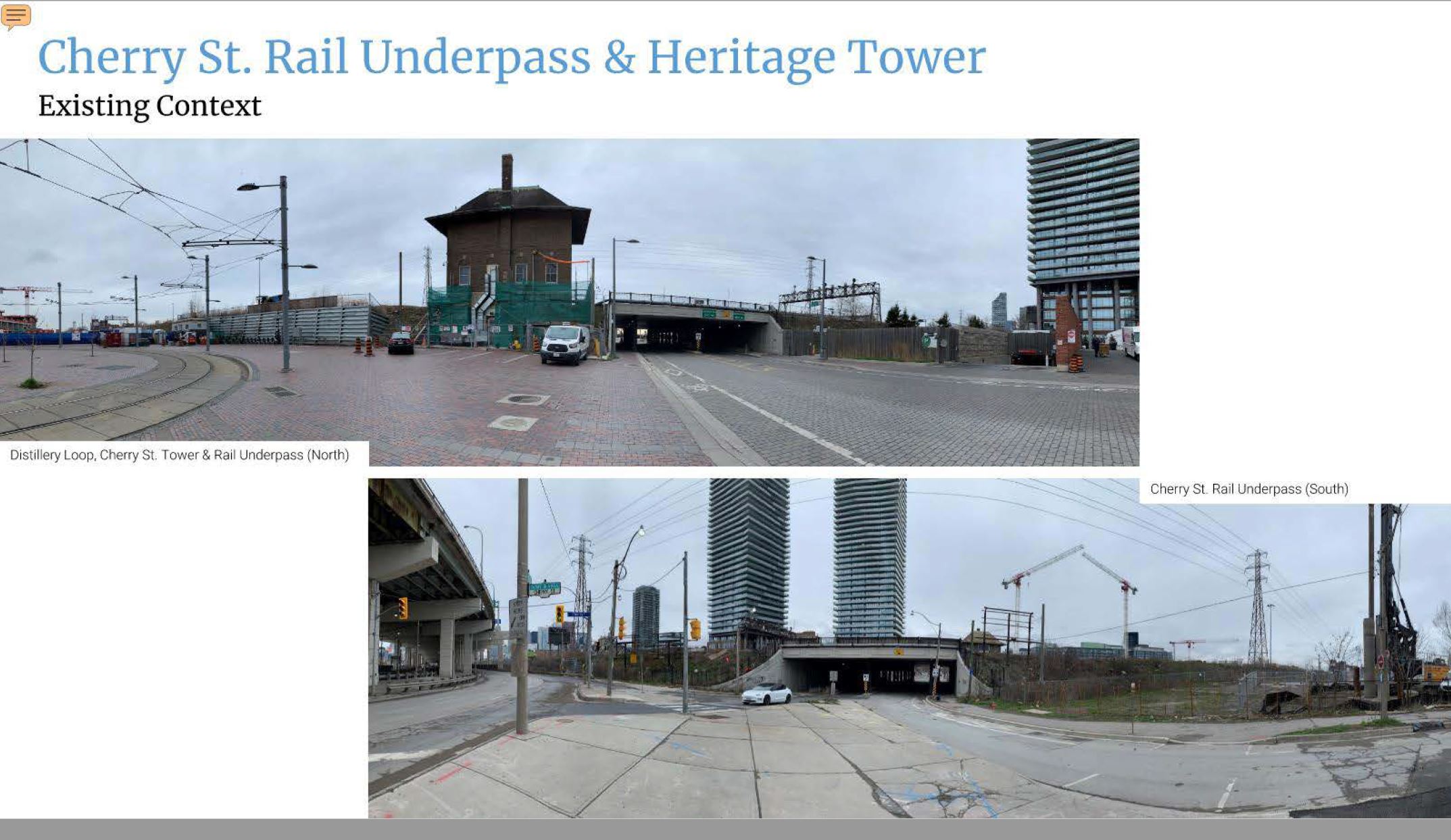
Here is Distillery Loop and the existing Cherry Street underpass at the rail corridor including the now inactive Cherry Street Tower which controlled switches and signals on the eastern approach to Union Station.
The June 2021 design proposed a plaza filled with cherry trees around Distillery Loop.
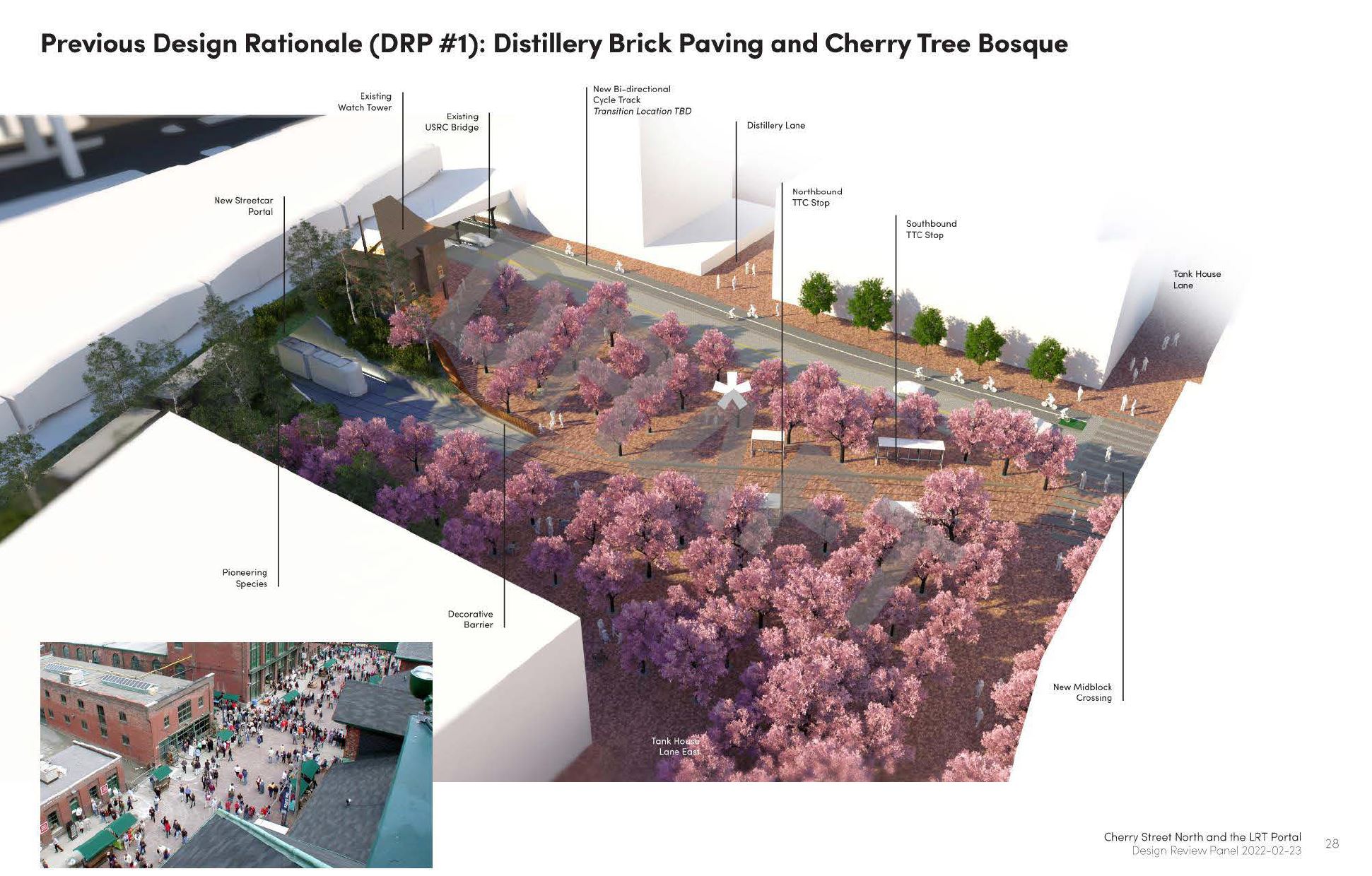
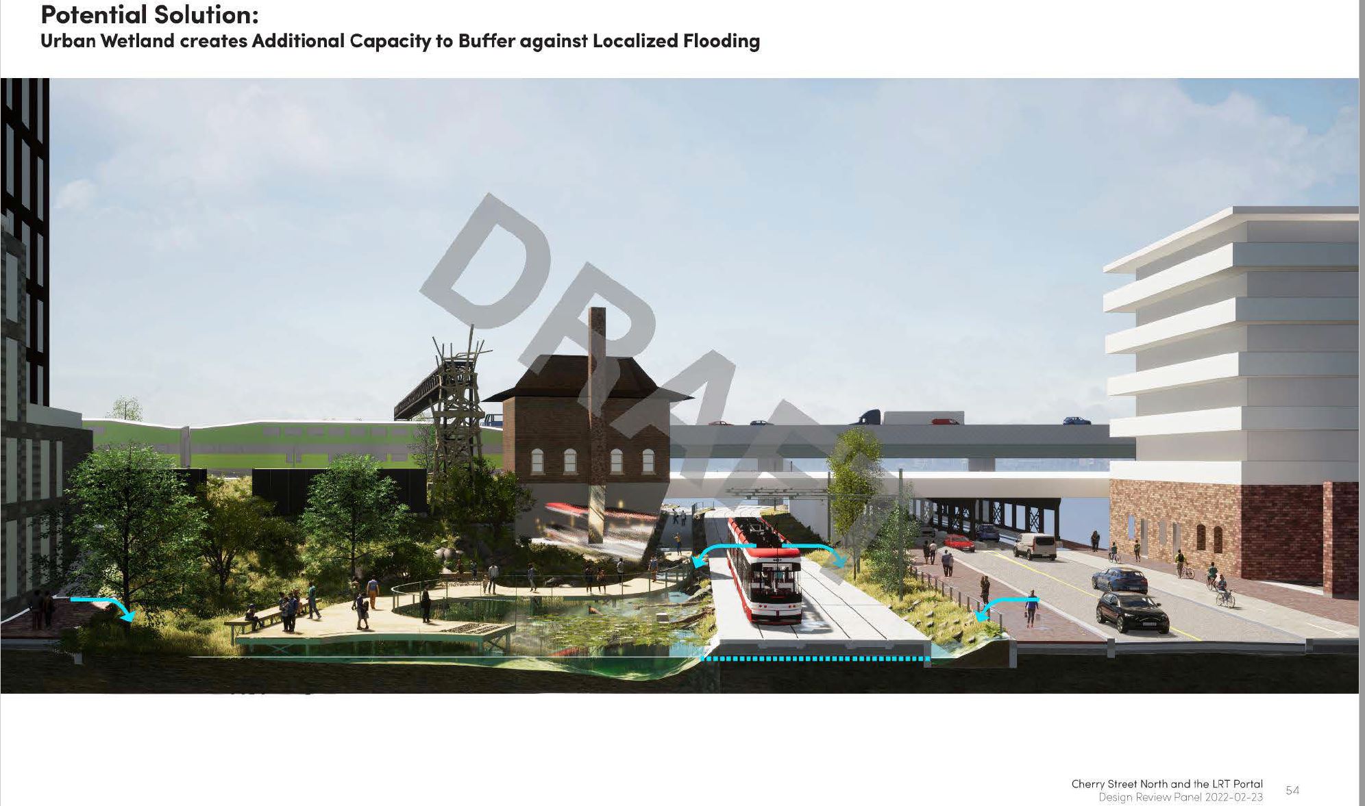
The proposed scheme shifts the tower east to allow a straight run of an extended streetcar right-of-way under the rail corridor.
Here is the same plan viewed from Mill Street looking south.

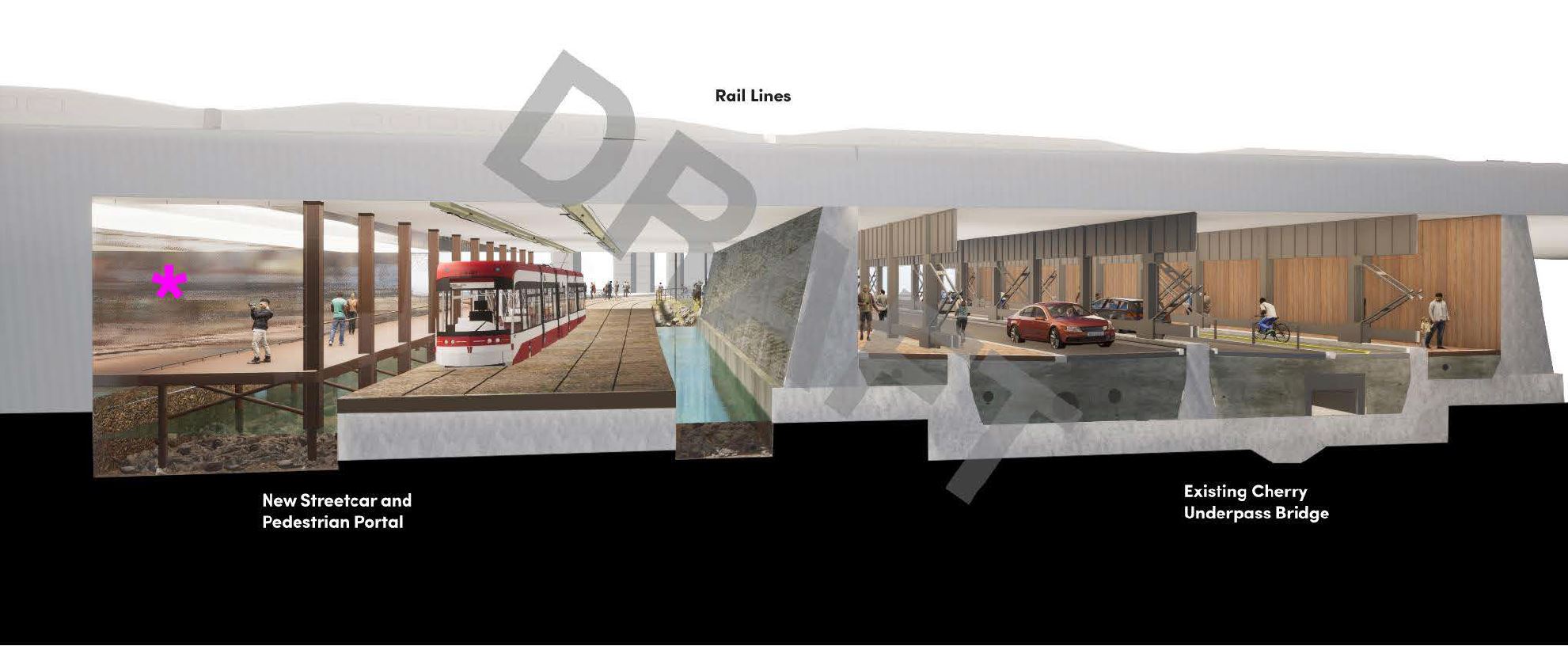
Attractive though this plan is, it ran into a major problem: the Cherry underpass is the low point of the area and it would be subject to flooding during storms.
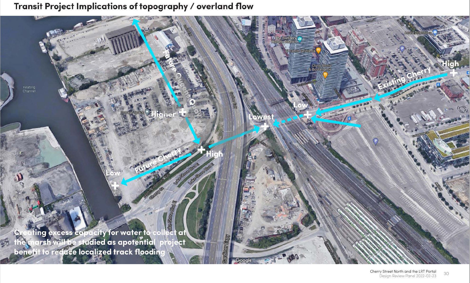
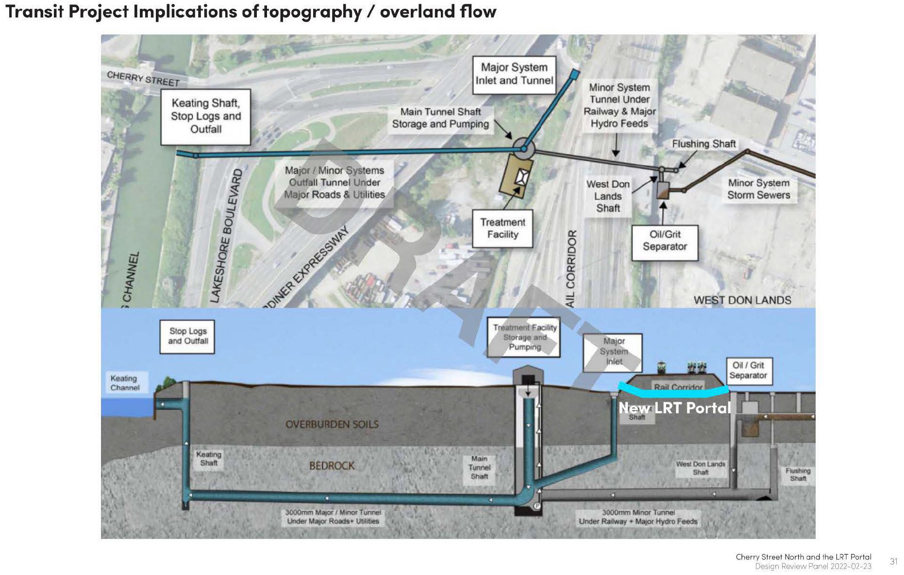
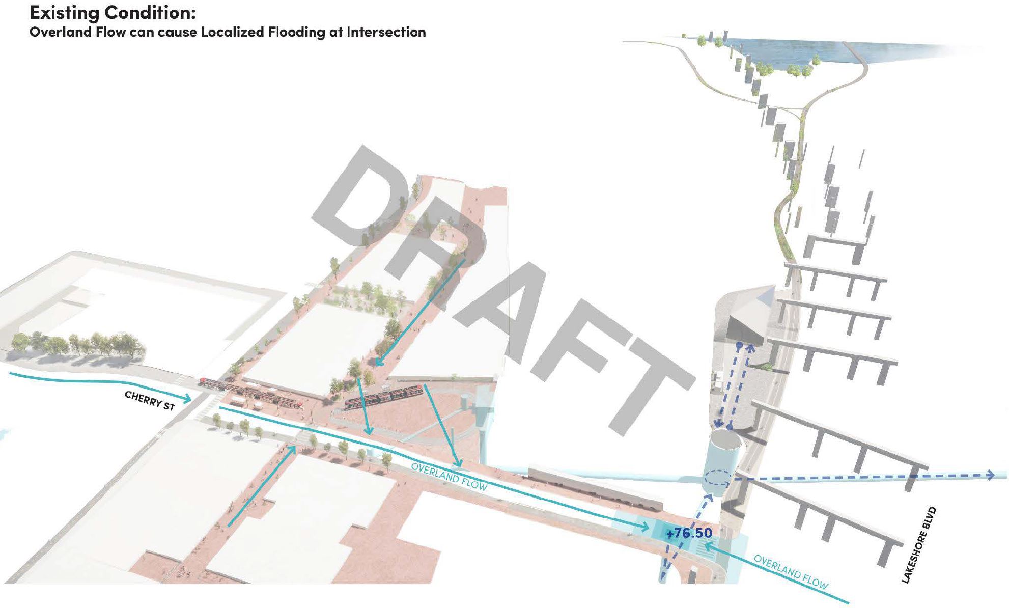
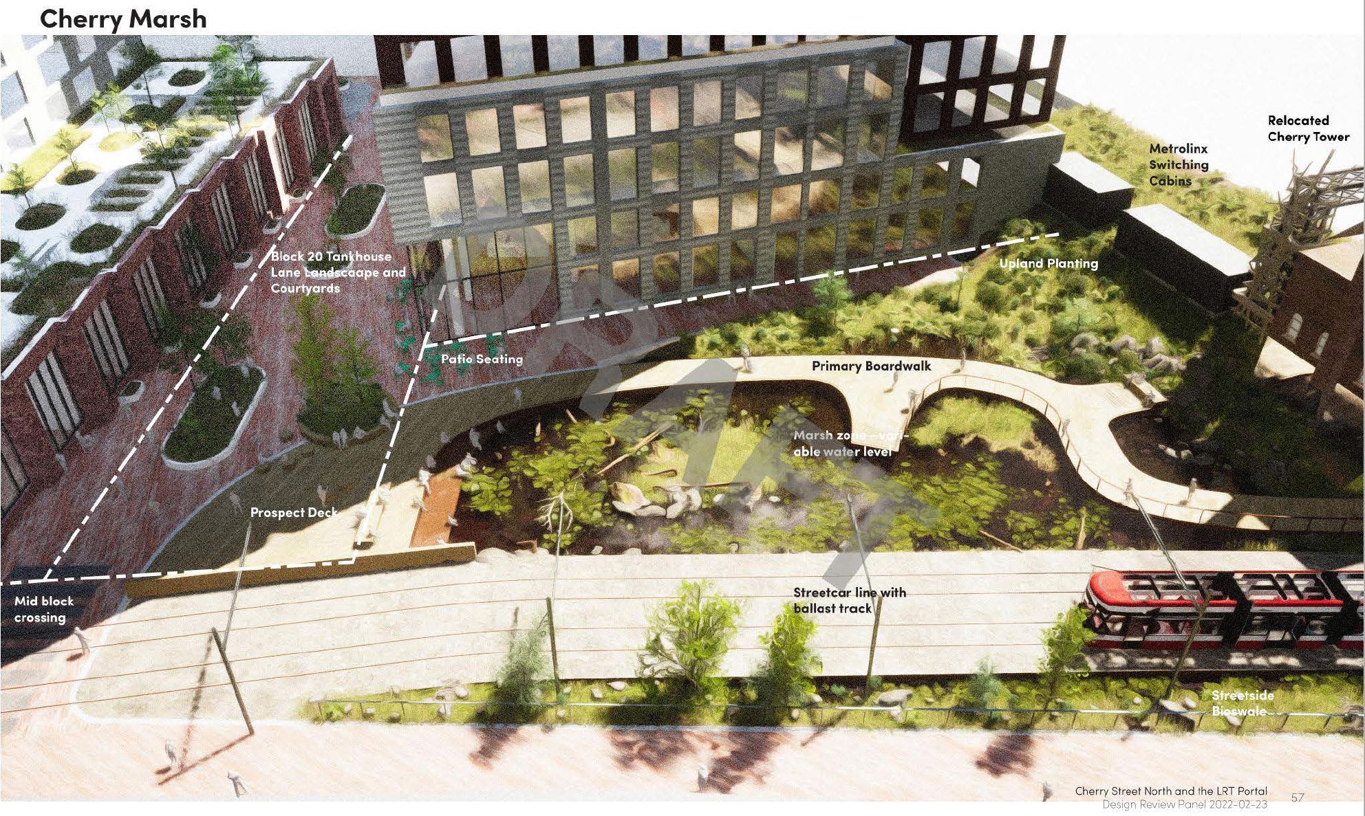
Rather than trying to fight against the water, the new design integrates areas to channel and hold water using a wetland at a lower elevation than the new streetcar right-of-way.
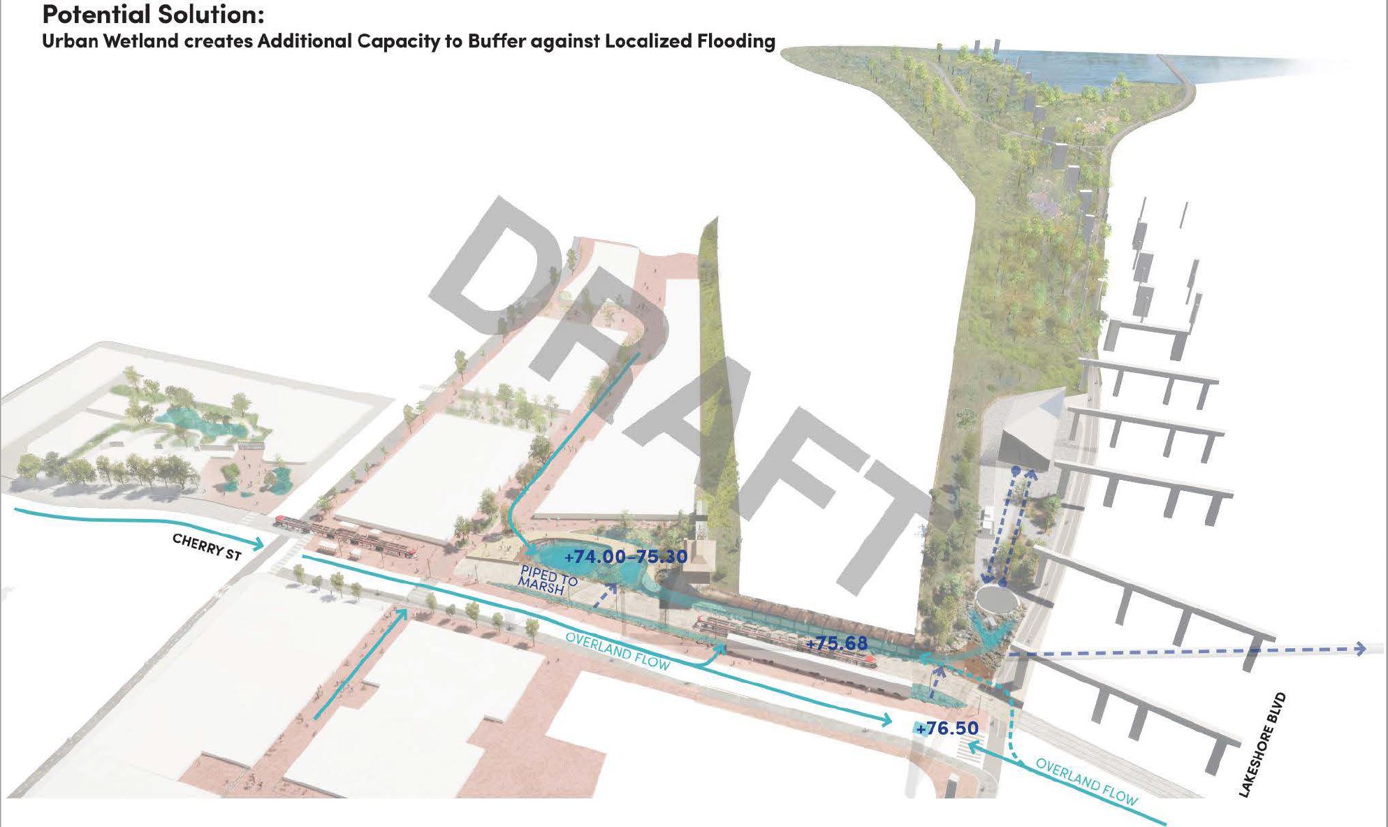
The result is a new marsh area akin to the nearby Corktown Common
In the image below, there is a ghostly streetcar emerging under the relocated Cherry Tower. This shows the alignment for the option that leaves the tower in place.
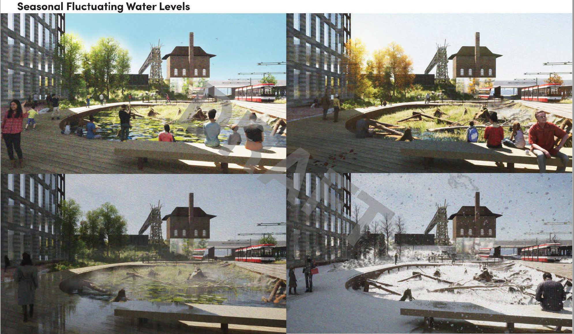
The marsh would vary in character through the seasons depending on the water level.
The view below looks south under the rail corridor showing the relationship between the existing, reconfigured underpass on the right, the new streetcar underpass on the left and the channels for water flow from the marsh.
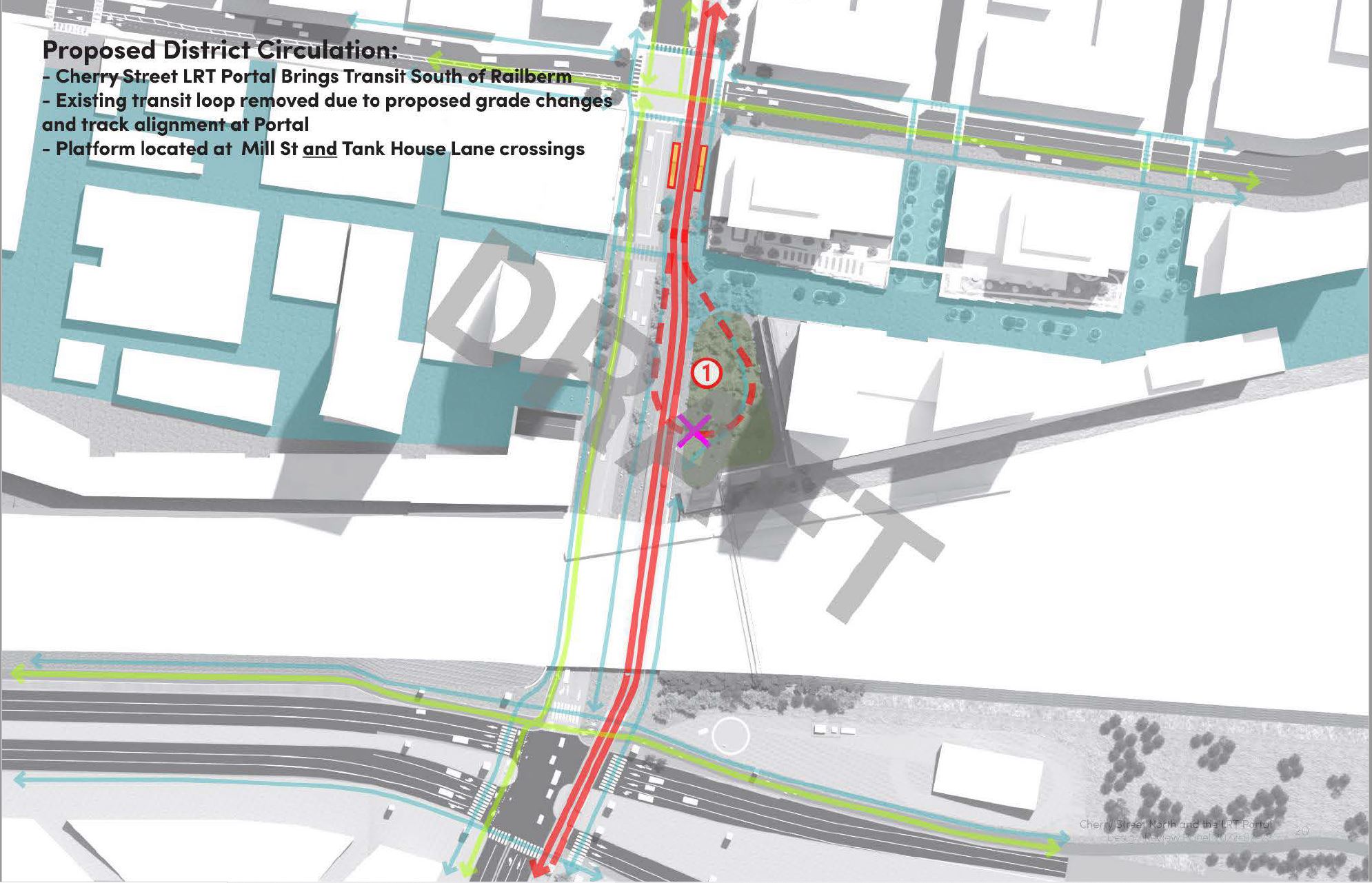
The new arrangement replaces the stop in the loop with a pair of stops south of Mill Street. Tank House Lane, which now ends at Cherry Street, would continue across Cherry to serve new development now underway.
In the map below, pedestrian circulation is shown in blue lines, and cycling in green.
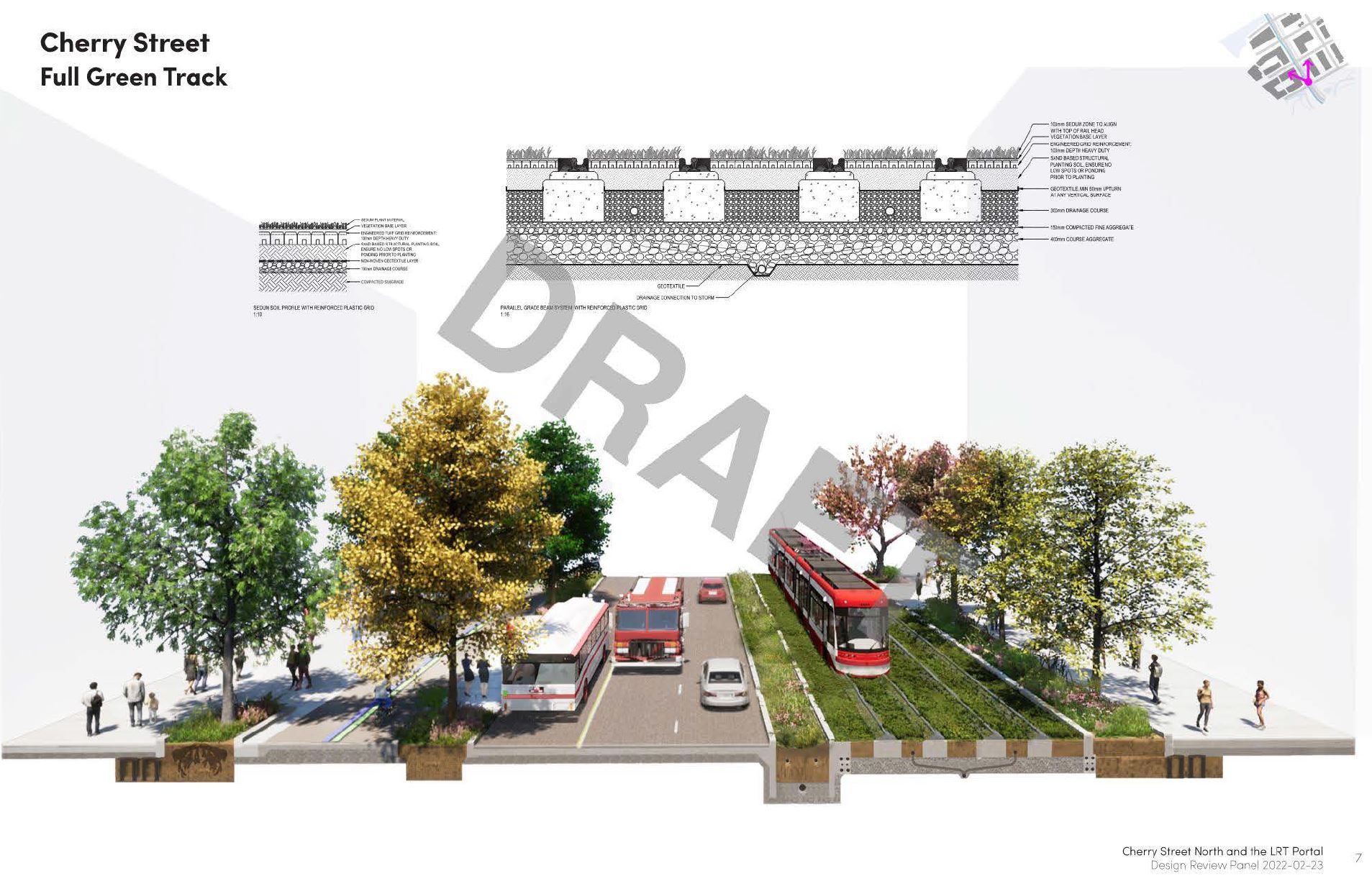
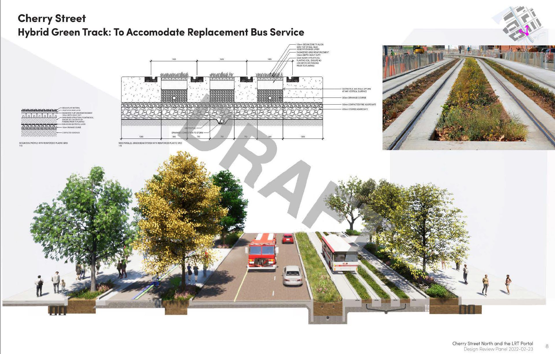
Among the design options possible on the extended streetcar line is the use of “green track” akin to what has already been installed on Eglinton’s surface section east of Brentcliffe Portal. One version uses a fully green trackbed, while the other leaves the track in ribbons of pavement separated by greenery.
The purpose of the hybrid paving is to support buses running on the streetcar right-of-way. A problem that is not addressed here is that buses, not tethered by the tracks, require more clearance than streetcars both to each other and to fixed infrastructure such as overhead support poles. This prevents two-way bus operation on existing streetcar lanes elsewhere in the city.
The mouth of the Don River and Cherry Street will see big changes in coming years. Today the river mouth is a huge construction site. Landmarks visible here include:
- GO Transit’s Don Yard (top of the image).
- The existing DVP and Lake Shore Boulevard.
- Keating Channel south of the Gardiner and Lake Shore.
- Villiers Street (south of Keating Channel).
- The old and new Cherry Street alignments.
- The new Cherry Street transit bridge over the Keating Channel.
- The new Commissioners Street road bridge over the future path of the river.
- The river meander under construction south of Commissioners Street.
- The ship channel (bottom of the image).
The view below looks south across the Distillery District, the realigned Queens Quay, Keating Channel (the current Don River exit to the lake), Villiers Island, the new Don River, the Ship Channel and Cherry Beach.

I don’t understand the point of a replacement bus hybrid scheme if a common reason for replacement buses is track maintenance. In those cases, the buses won’t even be able to use the ROW.
Steve: I suspect what is going on here is “temporary” bus service until they finish all of the corridor and find money to pay for the “LRT”. This has been hinted at a few times in consultation sessions already.
LikeLike
Personally, I would go with the greener option. Let the bus service use the road.
Three reasons for this; less concrete = smaller carbon footprint, more surface area for water to ground penetration = less runoff, slower flooding, and more reason to switch back to streetcars and a dedicated ROW!
I am guessing the option to swing east of Cherry Tower is slightly cheaper (tunnel only, no building move), or would this tunnel impact the exit point of the OL?
Is there room to keep the existing loop, expand it to work for both north and south exits, or does no real reason (other than redundancy) exist to keep the loop?
Steve: The change in grade needed to get under the railway works against keeping the loop, and definitely making it bidirectional would be challenging. The marsh concept probably fits in most easily if the streetcars take a straight run parallel to the roadway.
The OL exit point is not affected by the choice because it surfaces further east.
LikeLike
Keep the Cherry loop, add two track switches on the south part of the loop, for the southbound tracks be on the eastern side of the Cherry switch house that follows closely to the (blue) proposal, that short turns continue when required. Also integration of buses to use the streetcar right a way built in if service interruption or maintenance down time. (If there a way I could send email image so you have the perspective of proposal for the Cherry loop.)
Steve: The problem with keeping Distillery Loop is that the elevation of the track has to be changed to go under the railway. As for buses on the streetcar right-of-way, the design does not appear to take into account the wider dynamic clearance needed.
LikeLike
Though I agree that having separate north and south tracks under the rail berm is better, in Amsterdam they have several locations where streetcars go in both directions on one length of track because a street is very narrow. Who has right of way is controlled by traffic lights and it seems to work very well. Streetcar traffic on Cherry is not really ever going to be so frequent that sharing a track for a couple of hundred metres around the rail berm would be impossible. Of course, it has not been done here before so is likely to be deemed ‘impossible’.
Steve: I think you might find even a single track won’t fit within the existing underpass, and if we’re going to punch through a new tunnel it might as well be wide enough for double track.
LikeLike
Any mention of potential service patterns?
Union to Poulson Loop obviously makes sense. Union and the up Cherry St makes less sense to me. It would either need to continue east along Queen, or loop back west on King, which I guess could create kind of a cool loop line which heads all the way west to Spadina or Bathurst and then down to Queens Quay and back to Union.
I’m ignoring service on Commisioners and beyond because my understanding is that will be built later.
Steve: This was a Waterfront Toronto report, not a TTC report. I don’t think service patterns will emerge for some time in part because there will be a period when service cannot run north to Union Station during construction. There will also be a limit to how many services can run north to Broadview Station. This has become a tad more challenging since the idea of taking the Dundas car over to Gerrard Station as part of the Relief Line project was dropped.
LikeLike
With regard to loops, if they are going to eliminate the Cherry Street loop is this an argument for integrating a surface level loop into Corktown Station? There was an old unused loop there prior to the construction of the Staples and car dealership, on the SW corner. Would the handiness of using it for short turns make this a worthwhile idea?
A few years ago the plan for the streetcar route on Queen’s Quay, east of Yonge, was to have a terminating loop at Parliament. That seems to be missing from the current drawings.
Am I correct there are no loop planned for East Harbour, the station on the old Unilever campus?
Steve, thanks again for all your excellent work!
Steve: The old King and Parliament Loop was part of a land swap between the TTC and the City years ago, and the TTC still owns the TPA lot on Broadview, east side, north of Queen for a future loop that, it appears, will never be built. The Queens Quay loop at Parliament was always intended as a temporary terminus, but now that the work at Cherry is underway, it does not make sense to stop there and it has been deleted. Yes, there is no loop planned for East Harbour Station.
You’re welcome!
LikeLike
Oops. Something obvious I should have realized. If the water table is high, at Cherry Street, then the Ontario line is being drilled tens of meters below the water table. Duh. I don’t know why I assumed all of Toronto’s subway stations were above the water table. Is Queens Quay station below the water table? How about Union Station? Islington, Old Mill, Castle Frank and Broadview, stations where a ravine is crossed, all obviously above the water table. There might have been a risk of artesian well style gushers at High Park, another above ground station.
Steve: Queens Quay station is well below the water table. It was built as a “bathtub”. Remember that the lake is quite nearby. Union is fairly close to the surface although it can get damp down there at times. Everything south of Front Street is landfill in what was once Lake Ontario.
Other stations are below the water table, notably York Mills which has extra concrete above the box section south of the station to weigh down the structure and counteract the hydrostatic pressure of the Don River. There were also problems up on the Vaughan extension with high water from the Don River (yes, way up there).
Leaside Station at Bayview and Eglinton is below the water table. There is a branch of the Don River (it really gets around) called Walmsley Brook which passes under the intersection in a pipe. It poses a challenge to developers who eye the corner for high rises.
LikeLike
The Jane Loop, the western terminus of the Bloor Streetcar route, remained in service until I was eleven years old, in 1967. There was something very clever about its design I only recognized as an adult.
It had two concentric loops, an inner one, for streetcars, and an outer one, for buses.
There was a crescent shaped central platform, with a roof, for passengers for both buses and streetcars. Streetcars pulled into the inner loop traveling counter-clockwise, so their doors faced outwards. Buses pulled into the outer loop traveling clockwise, so their doors faced inwards.
So the doors on vehicles on both sides of the platform faced the platform, and nobody had to get wet, in the rain.
I’ve always wondered – do you know if the TTC ever built other loops to this clever design?
In the old classic days, of a fleet of over 700 streetcars, did the TTC have more loops available for short turns?
Maybe I am asking before your memory… Thanks
Steve: Examples that come to mind include:
As for your question about loops for short turns: Any loops that existed were for scheduled service, although in more recent times some survive only for short turns (e.g. Wolseley, Fleet, Coxwell-Queen, Sunnyside, Woodbine). When there were more streetcar routes, there were also more options for diversions or around-the-block short-turns.
LikeLike
In my opinion, building the LRT tunnel just east of the former Cherry Street interlocking tower is far more practical and less costly than moving the tower eastward. Doing so, apart from the cost, would seem to be quite challenging, with a very busy rail line on the south side, and a steep embankment on the north. If the LRT line, after emerging from the south portal, has to swing slightly to the west to line up with the new Cherry Street, so be it. This does not seem like a major issue.
Steve: If you look at the plan view showing the three alignments, you will see that the version going around the tower meets up with the one going straight south “through” the tower when they reach the Cherry/Lake Shore intersection. I think that one reason the straight alignment is preferred is that it puts the marsh between the streetcars and the building effectively as part of the building’s plaza, and keeps the streetcars over by the road.
LikeLike
I don’t know if there was any scheduled service to Moore Park loop, but I’m pretty sure that there never any scheduled service to Kipling loop. (And I suppose I’m writing this to be proven wrong. 🙂 )
Steve: Actually, Moore Park Loop (and service to it) began on December 1, 1924 before the line was extended north to Eglinton on November 4, 1925. There was also a short period after service ended on Mt. Pleasant that the night cars went to Moore Park.
LikeLike
I wonder if the TTC stopped running the night cars over to Moore Park Loop in the fall of 1976 due to complaints from nearby residents, and along St. Clair, about the “noisy” streetcars.
Re the Distillery Loop area; it sounds as though they want to have the LRVs further west (close to Cherry Street) so that the residents on the east side of the (present) loop won’t have to hear or see them to the same degree. More NIMBY appeasement, at great cost.
Steve: Using the word NIMBY is one step from getting yourself banned on this site. It is a catch-all used to mean “your opinion does not count” far too often.
The LRVs will run straight down the east side of Cherry more or less where they are (southbound) today. The big change will be elimination of the loop. The alternative that dodges to the east will have a gradual, squeal free curve. The layout of the marsh works better with the streetcar on the street side of the space.
And, btw, there is housing all along this route so any place you move the streetcar further from one building, you move it closer to someone else.
Find a better argument, or don’t bother.
LikeLike
I’m hopeful if WFT bankrolls this it may get done with in our lifetime, unless that pesky war escalates…. This addition to the Streetcar network would not only been really beneficial for those new residents it will also greatly increase the utility of the network.
Steve: Waterfront Toronto does not have the money in its own right to build the eastern waterfront LRT network. That’s up to the City and Province, and I expect to see a lot of foot dragging there. The transit improvements here are years overdue, and new neighbourhoods once trumpeted as “transit first” are facing years of inferior bus service.
LikeLiked by 1 person
These proposals are now for a two way bike path on west side of Cherry. Ideal would have been directly east of the streetcar tracks, as that eliminates virtually all conflict with turning vehicles.
LikeLike