
Design of the Waterfront East LRT is still underway by Waterfront Toronto and the TTC. Whether this project will be funded in the near future and built remains to be seen, but one issue is now settled, pending public feedback and formal approval.
The question has always been “where will the line end”, at least in the interim configuration before the full buildout of trackage in the Port Lands.
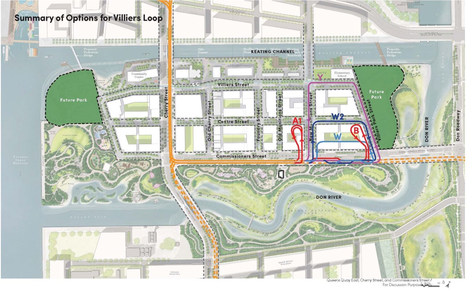
Here is an overview map of the area. Note that it shows the configuration the rerouted Don River, and the new alignments of Cherry Street and of Queens Quay.

- Starting at Union Station, the segment in red south and east along Queens Quay to the portal west of Yonge is a TTC design task that is now underway.
- The blue segment along Queens Quay east to Cherry is a Waterfront Toronto design project. Note that it crosses a partly filled Parliament Slip (purple) rather than dodging north to Lake Shore Boulevard as Queens Quay does today.
- The yellow segment is on New Cherry Street and Commissioners Street. It will include an extension of the streetcar network south from Distillery Loop and east via Commissioners Street. For those who are familiar with the area, New Cherry and the transit right-of-way will cross the Keating Channel on two new bridges (the red ones for those who know them).
- Various extensions (dotted black lines) are proposed:
- South via Cherry to Polson Street. This will take the line over the new Don River and will require twinning the existing yellow bridge where New Cherry makes the transition into Old Cherry as it crosses the new Don River.
- East via Commissioners to Leslie Barns making a second connection to this major TTC site and a possible service through the eastern Port Lands. This will require twinning the double-span orange bridge which will carry Commissioners Street over the new Don River.
- North via an extended Broadview Avenue to connect with GO and the Ontario Line at East Harbour Station and thence north to Queen Street.
Various options were considered for a loop on Villiers Island, the new island created by the rerouted river on the east and south, the Keating Channel on the north and the harbour on the west.
Options A and B would provide offstreet loops west of New Munitions Street, or west of Villiers Park respectively. These were rejected because they would prevent development of those parcels until the line was extended and the loop was abandoned.
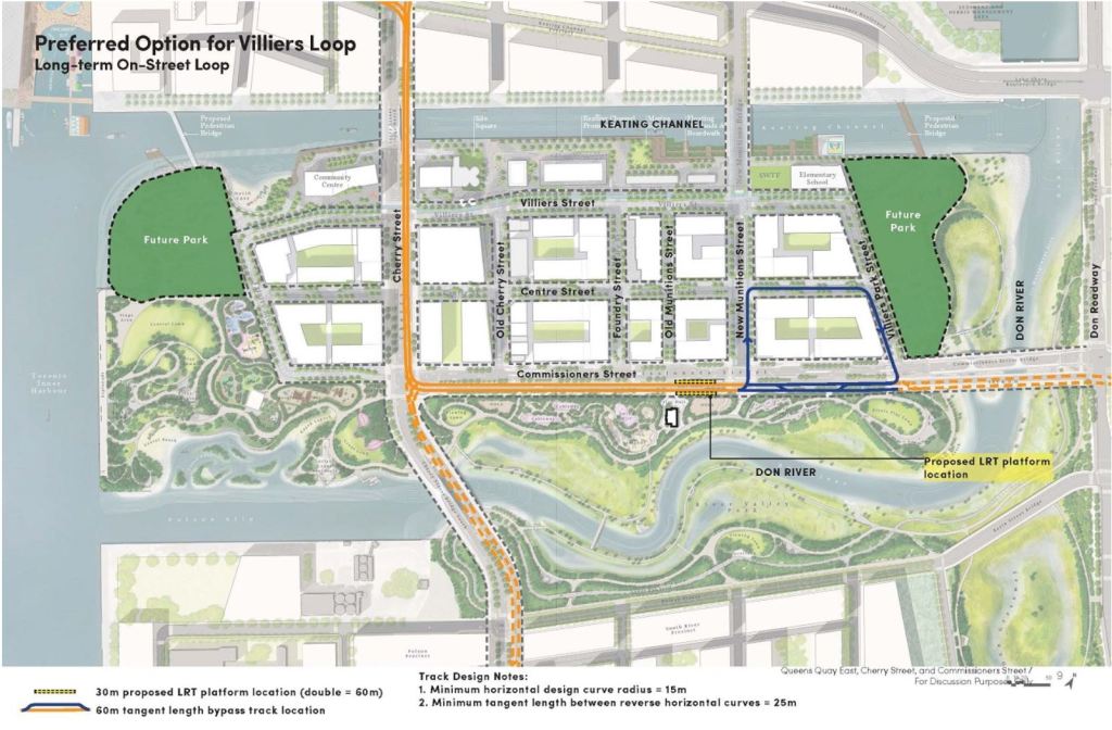
Option W2 is entirely on street, and it was the preferred configuration. This also builds the Commissioners Street trackage to the eastern limit possible without the new transit bridge in place.
The track on Commissioners Street is in its own right-of-way allowing for a layover space on the eastbound track on the south side of the around-the-block loop.
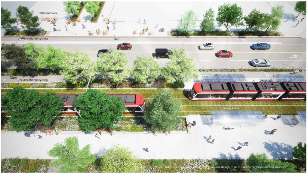
The streetscapes for the double track and single track sections are shown below.
While this design might “nail down” at least the interim terminus of the WELRT, what we do not yet know is the proposed construction staging. The Bay/Queens Quay segment will be the most difficult to build because of the underground works at Union and the creation of an east portal at Queens Quay.
There is also the question of development timing in the Cherry Street area and when better transit service there will be required. Current plans assume that the line will operate with buses on an interim basis. It is likely that the project will be built in stages and portions may open before the Bay Street tunnel modifications to maintain waterfront service.
Waterfront Toronto plans an update for public consumption in the Spring with a report to Council in mid-2023.
Additional materials were presented at Waterfront Toronto’s Design Review Panel on January 25, but these have not yet been posted online. I will update this article when they are available.
See A Walk on New Cherry Street for construction photos of the area as of early October.
See Extending the Waterfront East LRT to Villiers Island on Waterfront Toronto’s site.

They really need to bite the bullet and transition to ordering all future legacy network cars as double-ended. So many of these endless debates about where to place land-heavy terminals (loops) would be much simplified if turnarounds were as simple as placing a crossover or wye. I mean how long have they been thinking about Park Lawn or Broadview loop and doing nothing? Or Parliament loop before that idea was abandoned?
In the context of this project, where would a Broadview line terminate? Does it hook up with the waterfront east line like Spadina does with the west side? Is it its own separate route that takes up space in the clockwise loop? Does it get its own counter-clockwise loop around the block? What happens to the 504A when its terminus gets removed? Are we going to get 3 or 4 routes sharing an on street loop? Get double-ended cars to minimize the amount of space needed to turn cars around and avoid the Union gong show in the port lands.
LikeLiked by 2 people
I don’t understand the point of optionally turning.
Steve: I don’t understand your question. Did you submit it incomplete?
LikeLike
The presence of those single crossovers in the proposed track layout only highlights how foolish it is for not moving to double-ended cars. They’ll build all that extra track and electrical plant around the block and waste operator-hours circling the loop for its entire life, all to traverse a crossover they were going to build anyway.
It’s too late for the 60-car order but this has to be a priority for the future. Service has been hampered so much by the constraints dictated by loop requirements. Think the 501 Park Lawn extension, 512 St. Clair extension, even Union to an extent.
There are other benefits beyond the low cost and ease of adding new turnback points. The TTC would be better neighbours by eliminating the need for cars to grind and screech their way around loops. At existing terminals like Neville Park, they could potentially add extra sidings and store multiple cars offstreet rather than in the middle of the road. They could also store disabled cars there like they used to in the old days. It’s time to bring them back.
LikeLiked by 1 person
I am a big fan of building the final configuration from the beginning, to minimize upheaval later on when people actually live in this neighbourhood. If the final loop is going to be W2, for example, then just build it now.
I am not sure it makes sense to have a loop here, but that depends on what further extensions of the line look like. I know there is a general future layout of tracks, represented by dotted lines on the maps, but I would have thought that there would be a specific future plan, both for infrastructure and operations, and this would drive the location of loops. Will we have both Commissioners Street and Polson loops? I wouldn’t have thought both were needed, but rather just one. Why is the Commissioners Street loop preferred?
Steve: The Commissioners Loop avoids the need for a twin of the “yellow bridge” carrying Cherry south over the new river. Also, the assumption is that development south of that channel will occur considerably later. On a larger scale, I have my doubts that the Broadview extension will ever be built, and without it the Commissioners extension (which also needs a twin of the “orange bridge” plus relocation of hydro towers) is very unlikely. The Commissioners Loop serves both sides of Villiers Island as an “initial” service that may be more permanent than we care to think.
LikeLike
Looks good, but shouldn’t there be a streetcar stop on Centre St closer to Villiers Park St? If the streetcars go there anyway, they could carry some riders.
Steve: Yes, definitely. There is no point about talking about park access as a rationale for the leg along Commissioners without actually putting a stop there. A stop on Cherry is needed too.
LikeLiked by 2 people
I must admit, I have not been in the Port Lands area for at least a couple of years and that last time was via the 514 King streetcar to the Distillery Loop on Cherry Street.
I do not know what has happened there since, or will be. All the planned new roads, loops, islands, and different-coloured bridges, it is confusing. All is in flux.
There are various timelines for the build-out of the Port Lands, public infrastructure and buildings.
Steve said:
In that regard, it was said previously on this blog that a by-pass of the Union Loop as a surface-only LRT ought to be considered, in the interim. That is, the LRT would run straight through on Queens Quay. And it has also been said that it is most desirable to have transit infrastructure in place before development rather than as an afterthought.
Steve said:
As proposed transit projects go, this one is really quite simple.
Looking at maps, there is no need to cross any bodies of water. Cherry Street reconstruction is not a factor either.
The Union Loop bypass can be permanent. That is, the 511 Spadina car would continue as is, but the 509 Queens Quay would make stops at street level at Bay Street (ferry docks). No need to rebuild the current underground infrastructure at Bay, either.
Therefore, would it not be most prudent to build the QQ line out eastward to connect with the existing Leslie route as the first phase?
Oh, and btw, the 509 could be extended westward from Exhibition Loop to Dufferin Loop, only a one kilometer distance.
Your thoughts, Steve?
Btw, congratulations on both your 50th and 17th anniversaries!
Steve: There will definitely be a period where the new east portal has been built, the Bay Street tunnel is closed, and there will be through east-west service to Cherry Street. That’s part of the staging exercise, and it has *not* yet been finalized, but it makes sense. As for the Cherry connection, it requires a link south from Distillery Loop under the rail corridor. The bridge over the Keating Channel for New Cherry’s streetcar lanes is already in place.
An early link to Leslie is unlikely because of its length and issues with existing hydro infrastructure.
As for Bay Street, there is a substantial demand between Union and the waterfront that you cannot just wish away. That tunnel/station expansion will probably be the last part completed.
LikeLike
Depending on the phasing of construction for the Waterfront East LRT and the TTC’s willingness to build some non-revenue track to allow for diversions it would have been useful to have a way to bypass the Bay St. tunnel without having to shut the entire Queens Quay corridor to streetcar service. The current layout on Queens Quay West makes bustitutions problematic.
Provided the tracks on Queens Quay get built first with a suitable eastern terminus, running tracks along Harbour St. (could they co-exist with the bike lane if they’re only used occasionally?) between York St. and Freeland or Cooper through the redeveloped Toronto Star and LCBO lands would allow for the corridor to continue to operate with streetcars as a through route. I know it gets a bit tricky between Bay and Yonge. A transfer would be required to access Union Station.
Once the wye is built just past the Ferry Docks station, assuming all the curves are put in at either end of the Harbour St. diversion it could serve as a loop for both ends of the Queens Quay routes when the Bay St. tunnel inevitably needs to be shut down again. The demand along the existing Queens Quay West coupled with the traffic levels at rush hour or any time a game or concert lets out makes using a substitute shuttle bus even more of an ordeal. Finding a way to maintain as much streetcar service in its own ROW is important.
Steve: FYI Harbour Street will be extended to Jarvis as part of current redevelopment.
LikeLike
Gil, thank you for your reply! We agree with each other about the need for Queens Quay East transit.
I had to look at a map to see exactly where Harbour Street is. Not like I had never heard of it, and there is also the old Harbour Commission building. Apparently, I drive on Harbour Street often – I know it as the off-ramp from the Gardiner Expressway eastbound for York-Bay-Yonge.
I am not too sure about using Harbour Street as a streetcar bypass around Queens Quay. It is jammed with vehicular traffic, especially those making lefts at York or Bay. It is narrow and cramped. It ought to be rebuilt or the lanes redrawn for its own sake.
Steve said:
Agreed. Eventually the east QQ portal will need to be built.
But, Queens Quay is no problem compared to all the cars jamming the area. When I come down to Toronto from Caledon, I must drive because there is practically zero public transit, I have no choice. Every year, the situation is getting worse. Where are all these cars coming from? Are they all Ubers? Rarely a car with a second passenger. Yes, I support road tolls! Yes, I support building condos with no parking.
LikeLike