The Tangled Web of Waterfront Transit and Sidewalk Labs

The Waterfront East LRT (streetcar) is a years-overdue project. Development marches east from Yonge to the Don River along Queens Quay while transit service amounts to a handful of infrequent and unreliable bus routes. I strongly support the LRT plan, and participated in various advisory groups at Waterfront Toronto and the recently disbanded Sidewalk Labs Mobility Advisory Committee with the hope of seeing the LRT project come to life.

Toronto as a city talks a good line about “transit first” in the waterfront, but does nothing to support this. There is always some other project more important. During the early days of SmartTrack, there were even claims that it would make the Waterfront East LRT unnecessary. That was complete balderdash, along with claims that ST would replace every other project, including a Relief subway line.

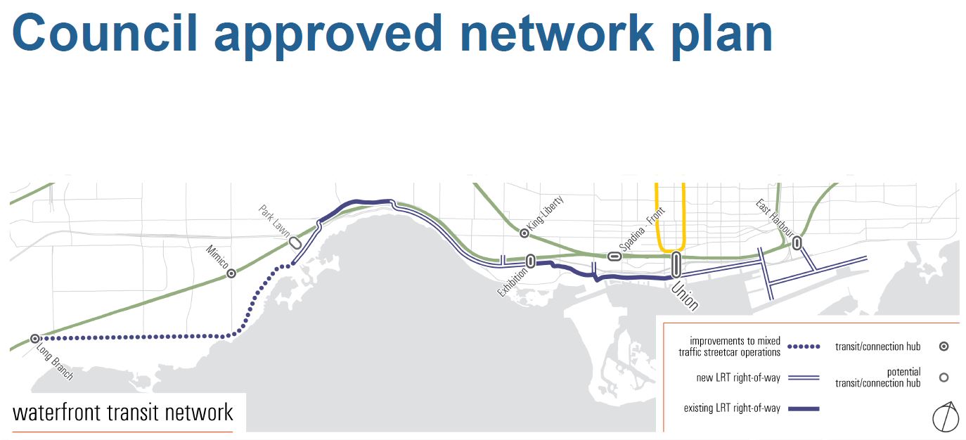
Now Mayor John Tory has shifted his position on ST’s benefits somewhat, but keeping his personal project alive diverts attention and funding. A Waterfront Reset study now underway by City Planning, Waterfront Toronto and the TTC owes more to the demand for better transit to the Humber Bay Shores than to the new developments in the eastern waterfront. Political dynamics on City Council are such that the western extension could be first out of the gate leaving the eastern waterfront high and dry, so to speak, for better transit. Design for an extension of the existing streetcar track at Exhibition Loop west to Dufferin with provision to go further is already underway. [See the Exhibition Place Streetcar Link tab within the Waterfront Reset page.]

The most contentious part of the Waterfront Reset has been the link to Union Station. One might think that simply expanding platform space there would be the obvious solution, but there are competing interests. Some residents and other activists argue for a surface LRT straight through the Bay & Queens Quay intersection to the eastern waterfront, while the existing Bay Street tunnel would be repurposed for various other technologies including a moving sidewalk or some form of “people mover”. For a while, Waterfront Toronto’s former CEO was pushing for a “funicular”, although the term is more applicable to transit routes on steep hills than in a relatively flat tunnel.

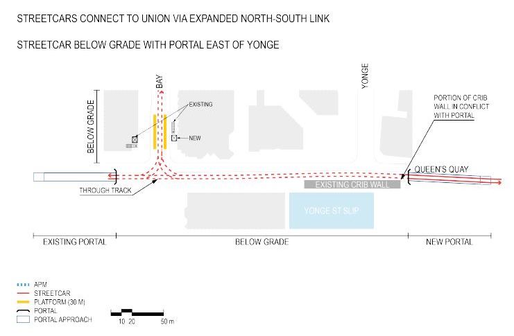
The existing underground streetcar infrastructure, consisting of a ~540-metre long tunnel under Bay Street from Queens Quay Station to Union Station, opened in 1990. This existing link provides connections between the central-western waterfront, TTC Line 1, GO trains and buses, and the lower downtown core. The existing streetcar loop at Union Station is currently inadequate for present service levels, to and from the west only, because of its single, curved streetcar platform, on a single track, with insufficient space for present volumes of waiting and alighting customers, and the loop would not function effectively or safely if additional service from the east was added.

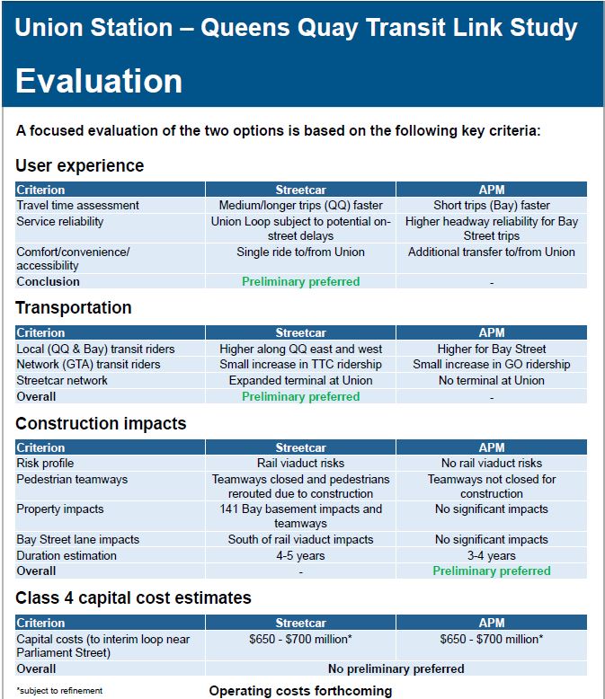
Currently, options for the link between Union Station and Queens Quay have been narrowed down to a short list of technologies: expanding the underground streetcar capacity at Union Station (loop expansion); or, repurposing the existing underground streetcar tunnel with an automated dual-haul cable-pulled transit system. The study area for the Union Queens Quay Link is illustrated below. [Waterfront Reset web page]

Two designs were presented at a recent public meeting, but I did not report on them here as there are still many details to be worked out. Drawings for these options are not available online.

  1. Two new north-south tracks are added under Bay Street, one on either side of the existing structure. Platforms would be built beside these new tracks so that passengers would load and unload along straight segments rather than on the congested curve at the north end loop. Two configurations are possible: in one all unloading would occur on the east (northbound) side with loading on the west (southbound) side, while in the other each side’s platform would serve one of the two waterfront routes. (For example, cars bound for Waterfront East could serve the east side platform while those going west stopped on the other side. The four-track structure would allow cars to bypass each other.
  2. The streetcar tunnel would be repurposed with a “People Mover” using one train in each half of the existing structure. Queens Quay Station would be substantially modified both as a southern terminus for the People Mover, and with a new underground LRT station. A surface option for this setup was dropped from the short list because of the volume of passengers who would be transferring between the PM and the LRT.

It is ironic that the impetus for removing streetcars from Bay Street came from the hope that the existing portal between Bay and York streets could be filled in, and that a new portal east of Yonge would not be required. However, the People Mover option, with its underground station, does not achieve this goal.

The next public meeting of the Waterfront Reset project will be held in the Brigantine Room at Harbourfront, 235 Queens Quay West, from 6:30 to 8:00 pm on Monday, March 4, 2019.

A third route into Union, the Bremner LRT, did not appear in the City proposals. It would, in any event, be impossible in the People Mover configuration. This proposal never made sense as Bremner is not wide enough to host an LRT route separate from Queens Quay West. A third service competing for platform space and track time at Union would make that interchange even more challenging than with only the west and east LRT services. City Planning could do everyone a favour by formally removing the Bremner route from their maps. This would also end a rather contentious debate about how a this route would affect the area west of Bathurst and south of Fort York.

The Union loop should and could have been expanded during the extended shutdown of streetcar service for the reconstruction of Queens Quay West and the nearby work on GO’s Bay Street Concourse (to which the expanded loop will connect), but there was no political will to spend money on streetcars at Union.

The Union Station connection will be the most expensive part of any upgrade to waterfront transit facilities, and this cost has been a drag on political decision-making. The Waterfront Reset is supposed to report to Council in April as part of an omnibus report on transit projects in Toronto. Once again, the waterfront could take a back seat to the favoured projects: SmartTrack and the Scarborough Subway Extension.

This is the context in which Sidewalk Labs and their proposed Quayside development join the story.

Quayside

Development of the waterfront has followed a standard pattern. Waterfront Toronto, funded jointly by all three levels of government, upgrades infrastructure (mainly utilities and roads), and manages the process for inviting development on public land that is serviced by the new facilities. Private developers bid for the sites, and Waterfront Toronto maintains input through its desigmn review process. (Some privately owned sites ignored WFT, but the majority of the land is in public hands.)

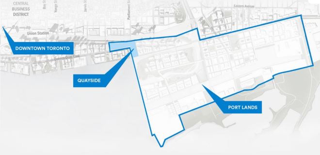
The Quayside site spans Queens Quay mostly between Sherbourne and Parliament Streets. What is quite striking here is the huge size of the Port Lands to the east and south compared with Quayside itself. [Map from Sidewalk Toronto website] The Port Lands are almost 30 times the size of Quayside and the same size as a large chunk of downtown’s business district. A share in any development there is a big prize.

Waterfront Toronto took a different tack with invited bids for a futuristic centre where new technology would be at the heart of the Quayside development. This would not simply be another new set of condos on the water. The winning bidder was Sidewalk Labs, a subsidiary of Alphabet Inc. which is also the parent of Google. This company has very deep pockets. Sidewalk Toronto is their local presence.

Original concepts for the area stirred both excitement and skepticism, but the debate quickly focused on technology issues related to invasive monitoring of activities at Quayside, the ownership of data collected, and the role of technology generally including autonomous vehicle (AV) technology from Waymo, another Alphabet company.

Central to the Quayside proposal is the reduction of the carbon footprint both through building design (construction and operating effects) and by shifting much transportation demand to modes such as walking, cycling, shared vehicles and transit. Transit is particularly important because the projected volume to and from the eastern waterfront exceeds 3,000 passengers per hour. The origin-destination pattern for these trips is not conveniently within the Quayside precinct, but spread over downtown. Incoming school and work trips originate even further afield. This is not a demand that autonomous vehicles can touch both for capacity and for reach of service in the foreseeable future, certainly not in the period when the waterfront will develop and be populated.

For me, the Mobility Advisory Committee was a frustrating experience. There was a clear conflict between Sidewalk telling us about their wonderful technology and the committee’s ability to review and comment critically, if only thanks to time constraints, the number of committee members and infrequent meetings. There was far too much “sizzle” and far less hard detail, not to mention a sense that Sidewalk was rather full of themselves about their brave new technology world. The design for Quayside includes provision for AVs, and to some extent the proposed road layout was gerrymandered to increase the contiguous territory where AVs could operate without having to deal with a major artery such as Lake Shore Boulevard.

A fundamental problem with any discussion of AVs is that Quayside is quite small, and most of the local trips within it would be taken on foot or by cycling. AVs might be handy for some journeys, but they would not be the backbone of travel because most trips started or ended well outside of the Quayside area. If AVs were going to have any meaningful presence in Quayside, the project scope had to expand, but how this would occur was not obvious until the Star’s revelation of Sidewalk’s and Google’s designs on the wider waterfront.

A parallel and much more high profile controversy related to the data that would be collected by a very technologically active environment integral to the Quayside proposal. This is a transit blog and I will not delve into all of the threads that debate took, but the discussion served an unexpected purpose. With all of the focus on privacy and the integrity of personal data, other aspects of Sidewalk’s scheme and their wider designs faded into the background. The cynic in me suspects that for all that this might have annoyed Sidewalk, there was an advantage that the bigger picture of development scope and infrastructure funding did not receive the same attention, at least until the Star broke the story.

There was always a nagging suspicion that the real prize for Sidewalk was the wider waterfront, but most discussions looked only at the comparatively small Quayside district. The problem with only reviewing that small precinct is that neither transit nor any AV scheme will rise or fall on the comparatively modest demand of one development district, but of the combined effect of building throughout the waterfront.

A Leak at Sidewalk

On February 14, the Star’s Marco Chown Oved revealed that Sidewalk had designs on the entire Port Lands. His article is based on a presentation deck that has not been released. I asked, and he replied:

A revised presentation was issued by Sidewalk, but it does not include some of the more contentious text cited in Oved’s article.

The foundation of Sidewalk’s proposal is that they would not only finance infrastructure installation throughout Quayside and the Portlands, but that they would be repaid by tapping into future municipal revenues. They would not become developers, but would reap their reward as others built in the area they had serviced.

Internal documents obtained by the Star show Sidewalk Labs plans to make the case that it is “entitled to … a share in the uptick in land value on the entire geography … a share of developer charges and incremental tax revenue on all land.” … estimated to be $6 billion over the next 30 years. [Oved]

This sounds promising if you are a politician accustomed to finding someone in the private sector to take costs off of your hands, at least in the short term. However, it is a form of borrowing just like any debt, and there is no indication of the return Sidewalk (or its funding parent, Alphabet) would expect on its investment. Moreover, there is a risk that economic circumstances will change over coming decades and development could slow or stop in Toronto. Would that risk be part of any deal, shared with Alphabet, or would they expect payment even for infrastructure supporting vacant lots?

Development Charges are poorly understood in Toronto. They are levied city-wide against all new buildings, both residential and commercial, to recoup part of the cost of infrastructure upgrades. They are not site-specific, and buildings everywhere pay the cost of new infrastructure regardless of where it is needed. For example, new buildings downtown helped pay for the Spadina subway extension. (Provincial rules on the DC formula require that the portion of any benefit to existing properties be excluded from the calculation.) It is far from clear that the DC revenue from the Port Lands would be needed only to pay for infrastructure there.

As for tax revenue, property taxes support many municipal services of which only a small portion is capital debt service. Scooping marginal new revenues to pay back Sidewalk’s investment would starve the city of money it needs to support the new population, and this would also dilute the funds available to service City debt overall. (I will avoid the black hole of explaining how City debt financing works here.)

The idea of “Tax Increment Financing” (TIF) has been floated before and it was central to John Tory’s SmartTrack scheme. This something-for-nothing mirage has evaporated. We will now see the City investing substantially in new GO stations while having no control over the service provided to them or the fares charged. Indeed, some of the waterfront lands Sidewalk eyes for TIF benefits were likely also part of the original SmartTrack scheme. One can only collect a tax increment once, and one might even debate which of several projects (SmartTrack, GO RER, Relief Line, Waterfront LRT) contribute to the uplift in land values and taxes.

The revenue streams Sidewalk seeks are municipal, and their proposal is silent on any investment from the provincial or federal levels. Waterfront Toronto, by contrast, is built on a tripartite arrangement with all governments, notably in its signature project the Don Mouth regeneration. If Sidewalk expects to be repaid for its contribution, where are the other “partners”?

Looking more broadly, other financing entities might be interested in this project, and Sidewalk/Alphabet should not be given any preference. One way or another, the investment has to be paid back, and the affected governments will have to get the best deal (including possibly some self-financing) among whatever is on offer.

Earlier I mentioned that it was clear that Quayside alone was too small to be significant in its own right for some of Sidewalk’s goals. Oved quotes Sidewalk Labs CEO Dan Doctoroff:

“We don’t think that 12 acres on Quayside has the scale to actually have the impact on affordability and economic opportunity and transit that everyone aspires to,” Doctoroff said.

This is not exactly news, but a great deal of “consultation” took place on the basis that only the 12 acres were under consideration.

Brand new in the Sidewalk proposal is a new Google Canada headquarters located on the west side of New Cherry Street, a prime spot within “Villiers Island”, a new island that will be created as part of the Don Mouth project. [From p. 10 in the updated Sidewalk presentation deck]

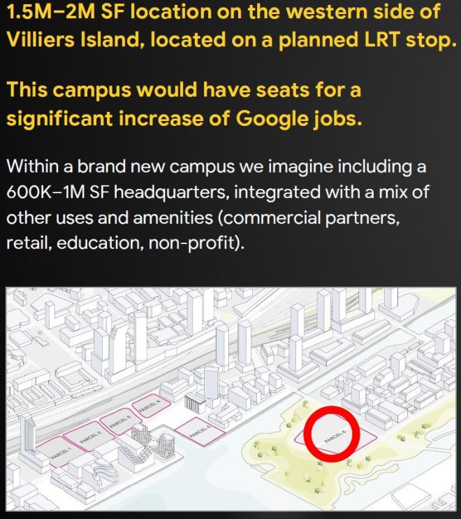
This would have an interesting effect on the initial size of Sidewalk/Google’s presence by placing a major employment node on Villiers Island. If Google/Waymo want a testbed for AVs, this would put their HQ firmly in the neighbourhood and would increase the initial scope of “AV territory”, although this requires that streets be “AV friendly”.

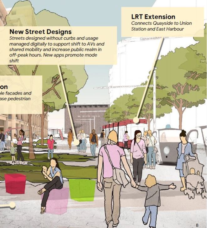
One big concern about AVs is their co-existence with the LRT line. In an illustration of the new Queens Quay, an AV is clearly shown in front of a streetcar on the “LRT” right-of-way. Bad enough that there is a conflict with AVs stopping on the right-of-way, but with the expanded scope possible to serve the Google HQ, will Waymo expect to use the LRT right-of-way throughout the eastern waterfront? Would this be a condition of the contract for any financing of the LRT project?

Sidewalk knows that the LRT is an important component of waterfront development.

To encourage development, Sidewalk will finance an LRT expansion through the area and fund the construction of “horizontal infrastructure” such as “the power and thermal grid, and waste removal.”

“This is something that is on nobody’s realistic drawing board. We would ensure it gets financed and all we want to do is get paid back out of the increase in value in terms of property taxes and developer charges that are only possible when that LRT gets extended,” said Doctoroff.

“To be clear,” Doctoroff said. “We would not own the LRT. It would remain public.” [Oved]

However, it is not clear how much of the LRT Sidewalk would actually finance, and if this were only the eastern end through Quayside, this could leave the critical link to Union Station in doubt.

In the wider scope, Sidewalk envisages a second phase with an LRT extension south of the Ship Channel to serve land that is now intended to be primarily industrial (at the east end) and recreational (at the west). There is no sense of whether this is a tactic to increase future returns, or simply blue-skying by Sidewalk’s planners. Going over the Ship Channel (twice) will be an expensive proposition as lift bridges will be required to provide clearance for ships entering and leaving the channel. (The existing bascule bridge on Cherry Street will remain, but it cannot carry an LRT line.)

Conclusions

I cannot avoid the sense that Sidewalk has badly overplayed their hand, and in the process has compromised whatever discussions were in progress on their plans.

According to Oved:

One slide states there have been “weekly briefings with officials from the three levels of government,” and “regulatory dispensations,” have been drafted to allow the plan to go ahead.

The whole Sidewalk process has been shrouded in confidentiality agreements, and this has not engendered trust with folks like me, not to mention Council members, who try to keep tabs on what is happening. It is a classic problem of public-private partnerships where all critical debate and decisions happen behind closed doors beyond the ability of anyone outside an inner circle to review.

How much has actually been committed is impossible to know. Sidewalk may have been told “if you want to do X, then you will need dispensation Y”. What we do not know is whether those dispensations are simply for discussion or have the active support of staff and politicians in the various governments.

Sidewalk’s position is further undermined when they reveal that they view problems with public perceptions to be related to the narrow issue of technology use and control [see Oved]. The broader implications of a runaway development scheme cooked up behind closed doors are not mentioned. Implications of widespread information technology presence are understood by a relatively small group, but questions of “done deals” and influence in high places are political issues everyone understands.

The entire proposal contains many sweeteners including sustainability, support for the emerging industry of wood buildings, and supposed improvements in the infrastructure of delivering services to a community. These may offset concerns about invasive technology, but are all of these simply a smokescreen for a much bigger grab for control of the Port Lands?

The ink was barely dry on the Oved story when David Rider reported that a source at Queen’s Park told the Star’s Robert Benzie that the plan “had no chance of proceeding”.

“There is no way on God’s green earth that Premier Doug Ford would ever sign off on handing away nearly 500 acres of prime waterfront property to a foreign multinational company that has been unable to reassure citizens their privacy and data would be protected,” confided the high-ranking Progressive Conservative insider.

All public agencies and officials involved in this project need to go on record about their knowledge of and support for the Sidewalk proposal. This is not the time for bromides about the wonders of new technology and much-needed development.

If we are giving away control of the waterfront, it’s time we all knew what is going on.

PTIF Phase 2: The Lottery Win Is Not As Big As It Seems (Updated)

Updated March 16, 2018 at 5:15 pm: The Fire Ventillation Project which includes second exits from several stations was omitted from the list of major projects in the original version of this post. It has been added.

Updated March 16, 2018 at 3:25 pm: The Ontario Ministry of Infrastructure has clarified that the Ontario funding for the Scarborough Subway is separate from the $4 billion in matching dollars shown in the table below.

On March 14, 2018, the Federal and Provincial governments announced the scale of the second phase of the Public Transit Infrastructure Fund (PTIF) to be spent over the next decade. Some of the details are in a backgrounder.

Funding allocations for the Toronto area are summarized in the table below. The amounts are based on transit ridership, not on population, and so Toronto gets by far the largest share of the pie.

Source: Infrastructure Canada Backgrounder

If one believed the ecstatic response of politicians and some media, one might think that all our transit prayers have been answered.

Not quite.

An additional $9 billion is not exactly small change, but Toronto has a huge appetite for transit spending and a daunting project backlog. The new money will help, but with it comes the requirement that Toronto pony up about $3 billion for projects that are not in the city’s long-term budget.

Capital planning for many years understated the infrastructure deficit by hiding projects “below the line” outside of the budget, and even more by leaving important work off of the list completely. The infrastructure deficit is much larger than the TTC reports and city financial plans indicate.

That, in turn, affects the city’s financial planning, subject of a recent report from the City Manager. Despite assurances from city staff that all known TTC costs have been included in their projections, there is a long history of the TTC leaving significant projects out of funding lists to keep their total “ask” down to a politically acceptable number.

Much needed work is not the sexy, photo-op rich stuff of subway extensions, but the mundane business of buying new equipment to replace old cars and buses, and to increase system capacity.

The new plan is to run for ten years. The money will not all land in Toronto’s hands this year, but will be parceled out as projects are approved and actual spending occurs. There is no guarantee that a future government will stick to any commitments especially if the “funded” projects are not the subject of a binding agreement. Toronto has its share of cancelled projects including the Sheppard Subway, cut back to Don Mills, and the Eglinton West Subway (both victims of Mike Harris), not to mention Transit City and the pliable attitude of various governments to the worth of a subway in Scarborough.

Updated March 16, 2018 at 3:25 pm:

Before we even start into the possible projects to be funded, some money is lopped off the top based on a past commitment.

  • Ottawa will provide “up to $660 million for the Scarborough Subway extension project, pending submission and approval”.
  • It is unclear how much of the provincial commitment to the SSE of nearly $2 billion is included in the $4 billion under the new program.

This brings the available federal funding down to about $4.237 billion.

Whether the total available from Queen’s Park is $6 billion ($4b new plus $2b for the Scarborough Subway), we do no know. I have a question in to the Ontario Ministry of Infrastructure to clarify this. They have acknowledged the question, but have not replied as of 11:45 am, March 16.

Update: The Ministry of Infrastructure has clarified how the previous SSE funding fits with the newly announced program:

Ontario is committed to cost-matching federal funding for municipal projects at 33 percent. This equates to $4 billion from the province to match the City of Toronto’s $4.9 billion federal allocation. No previously committed funding for Toronto projects is included in this allocation.

Ontario’s commitment to match this new federal funding at a 33 per cent share is separate from and above the province’s previous commitment of $1.48 billion in 2010 to the Scarborough Subway. [Email from Alex Benac, Press Secretary to the Minister]

Continue reading

Waterfront Transit Reset Phase 2 Update

This article is based on the public presentation held on September 18, 2017 at Harbourfront Centre. A similar presentation will be held in southern Etobicoke on September 26.

The “Waterfront Transit Reset” project was launched by Council at the end of 2015 to review all of the outstanding plans for transit from the Mississauga border to Woodbine Avenue. The first phase of this review reported in July 2016, and that provided the springboard for Phase 2 which will report to Executive Committee on October 24, and thence to Council at its meeting beginning on November 7.

Given the geographic scope, the review has been broken down into segments (and a few sub-segments) to focus on problems particular to locations across the waterfront. The four main segments are:

  • Southern Etobicoke
  • Humber River to Strachan including Parkdale and Exhibition Place
  • Strachan to Parliament including the Central Waterfront and much of East Bayfront
  • Parliament to Woodbine including the Port Lands

The presentation was done west to east, and in a single go without questions. This was something of a marathon for the audience, and I am not sure this was the best approach given the complexity of issues in some areas. As someone who has followed the detail of this study since its inception and participated in consultation sessions, I am quite familiar with the issues and was just getting an update. Those who came to this fresh, as many did, had a lot to take in.

A further problem is that the presentation included no cost estimates, and limited information on issues such as construction effects and complexity that could inform a choice between alternatives. This is particularly true of the review of Union Station. There are no travel time estimates to show what time savings, if any, various options present. Such estimates must exist as they are a critical input to the demand modelling process.

For this article, I will take a different approach and deal with the simpler parts of the study first just to get them out of the way, leaving the knottiest problems to the end.

Updated September 26, 2017 at 5:30 pm:

The presentation file is now available as a PDF. The display boards can be viewed on the project website.

Projected Demand in the Waterfront

The heart of any transportation study is the demand projection for various components under review. The chart below shows the 2041 AM peak hour demands forecast by the City’s planning model.

There is a fundamental difference between the projected demands from the western part of the line and the eastern one. From the west, the demand has the conventional inbound-to-core pattern for the AM peak. At the core and to the east, the peak flow is outbound, south to Queens Quay and east to new office and school developments.

This chart is missing some vital data that would put other parts of the discussion in a better context:

  • It assumes the presence of the Bremner link although this is the least likely to be built beyond an upgraded bus service.
  • There is no screenline west of Bay Street to indicate the demand arriving and leaving to the west right at the portal. With 2,350 going east and 3,700 coming south, this implies a substantial outbound demand to the west. Without the 750 each way on Bremner, these numbers would be higher.
  • The comment about higher demand in the east without the Relief Line does not explain whether the modelled values shown here include that line or not.

It is impossible to evaluate the demand numbers when there is no sense of staging of projects or of networks with some pieces “in” or “out” of the mix.

There is also no sense of the time frame over which the various demands will evolve, only that this is the 2041 end state. Any decision of the order of projects (and indeed their worth relative to other parts of the transit network) must be in the context of changes that are anticipated in the short, medium and long terms. This also begs the question of whether there are changes in the pipeline that will require heroic efforts in building up transit service to avoid short changing growing parts of the city (much as we already see in Liberty Village).

Another factor in any plans for the Waterfront network is the degree to which it serves major entertainment and recreational destinations. This will bring substantially stronger off-peak and seasonal demands that would be found on the transit network as a whole.

Ridership growth on the TTC has been stronger during the off peak period, if only because there has been so little growth in peak service. Strong off-peak demand is good for transit economics because the fixed cost of infrastructure is spread over more hours and riders, but the flip side is that peak riders have more incentive to abandon the TTC.

Continue reading

Waterfront Reset Public Meetings

My apologies to readers for not posting this sooner.

Waterfront Toronto, the TTC and the City of Toronto are holding two meetings to present the results of work on the “Waterfront Reset” project, a review of the various waterfront transit plans.

After the September 18 meeting, I will post a commentary on the proposals.

Pantographs Up On Harbourfront

On Tuesday, September 12, 2017, the TTC began operation of its new Flexity streetcars with pantograph power collection on the 509 Harbourfront route. This is a short, comparatively isolated route running entirely with Flexitys where problems, if any, can be ironed out on a small piece of the network. Any off route moves including carhouse trips are done with trolley poles, and the normal changeover point between modes is at Exhibition Loop.

Here is a small set of photos of the route.

SmartTrack’s Next Steps

After a day-long debate, Toronto Council has approved continuing along the path set by Mayor John Tory to study and possibly to build the transit lines branded as “SmartTrack”. Although this proposal is now much different from the scheme that was Tory’s campaign centrepiece, the idea of SmartTrack continues to receive broad support among Councillors.

The debate covered a lot of ground with two related threads: how would Toronto actually pay for SmartTrack, and how much of the larger transit network many hope to see will actually be built.

Council has yet to consider a long-term financing strategy and possible “revenue tools” (new taxes in plain English) to deal with the combined capital and operating budget demands of the would-be network. Although there was much talk of the lost decades of underinvestment in transit, Council has yet to show that it really is ready to spend Toronto dollars (as opposed to  money from any other source) at the level that will be needed. City staff will present a report on financing options in a few weeks, and the reaction to this will be telling.

What Did Council Approve?

Below is a consolidation of the staff recommendations and amendments adopted by Council arranged to keep related issues together. For full information, please refer to the detailed record of the item.

Note that in all cases where approvals relate to “SmartTrack” this includes both the six new GO stations and the Eglinton West LRT extension unless otherwise noted.

Process:

  • (1) Adopt the “Summary Term Sheet and Stage Gate Process” which includes details of the many parts of the proposed agreements and (2) authorize the City Manager to negotiate and execute agreements with the province to implement this.
  • (3) Request staff to report at Stage Gate 5 for final approval of full funding for SmartTrack. A report on more definitive costing and the financing funding strategy has been requested for an earlier step in this process. See (18) below.
  • (4) Approve the confidential staff recommendation regarding settlement of the Georgetown corridor funding issue. See also recommendation 15.

Technical and Planning:

  • (5) Proceed with planning and design for the six SmartTrack GO stations, report back to Council, and launch the Transit Project Assessment Process (TPAP). This was amended by two further requests that the work include improvement of:
    • the placement and access points of the Liberty Village Smart Track Station to maximize connectivity, and
    • pedestrian connections to the existing Exhibition Place Station for both Liberty Village and Exhibition Place.
  • (6) Confirmation of city support for transit supportive land use plans for areas around the SmartTrack and GO RER stations. Amendments related to this included:
    • Amending the development strategy for public lands at stations, including air rights, to create ongoing operating revenue streams from development resulting from that strategy.
    • Directing the Chief Planner to report in January 2017 with options to develop a comprehensive plan for managing development and growth related to transit expansion.
    • Confirming that the Official Plan as well as other plans, bylaws and policies, are not changed by this decision on this item. The intent of this is to forestall any claim for additional density by would-be developers in advance of the passing of updated plans for area affected by transit projects.
  • (7) Proceed with planning and analysis of the Eglinton West LRT extension up to Stage Gate 3 including finalization of stops and grade separations, provide a scope for this project up to the Renforth Gateway, and provide a class 4/5 estimate of the project’s cost, and conduct the TPAP. Note that this is a more restrictive approval seeking more detail than in the case of the ST/GO stations in (5) above.
  • (8) Request a financial contribution from Mississauga and Pearson Airport to the outside-416 portion of the Eglinton West extension.
  • (9) Ensure that the proposed new station design at St. Clair and Keele includes improved road operations and is co-ordinated with the St. Clair West Transportation Master Plan. A significant part of this would be the widening of the underpass east of Keele Street to remove the existing choke point.
  • (10) Request Metrolinx to consider grade separations at Progress and at Danforth on the Stouffville corridor, with the proviso that any option closing existing roads would not be considered. This was amended at Council to add requests for grade separations at Passmore, McNicoll, Huntingwood and Havendale.

At Council, there was an attempt to have items (7) and (8) deferred until after the Waterfront Transit Reset report is considered by Council in 2Q17, effectively putting both of the proposed Etobicoke LRT proposals on the same approval timeframe. The deferral motions did not pass.

Finance:

  • (13) Approve $71m for preliminary planning and design on SmartTrack (the 6 new stations plus the Eglinton West LRT)
  • (14) Include $2b in net capital requirements for SmartTrack (stations plus LRT) in the city’s 10 year capital projections.
  • (15) Approve $95m for settlement of the Georgetown South issue with the province.
  • (16) Approve $62m for Toronto’s share of 5 grade separation projects.
  • (17) Approve $60m for GO capital expansion (2 stations at Bloor/Lansdowne and at Spadina on the Barrie corridor). This was amended to ask that staff work with Metrolinx on including the study and design of the Railpath along the Barrie line between Bloor and Dundas West.
  • (18) Request staff to develop the financing and funding strategy, and report back when a class 3 cost estimate is available for a definitive Council commitment to the SmartTrack project.

Two additional amendments ask for:

  • strong TTC in developing procurement options, and
  • negotiations with the province for resumption of operating subsidies.

Commitment to the full cost of the new stations and the Eglinton West LRT will not occur until much more detailed cost estimates come back to Council over the next year (or possibly more). In the event that Council opts not to proceed with any component for which Metrolinx has spent money on development prior to the point of final approval, Council will be responsible to reimburse Metrolinx for its costs.

With respect to the additional grade separation studies requested for the Stouffville line, it is unclear how work on this would be funded, although one might expect Metrolinx to respond with a request for some up-front payment and guaranteed participation in funding if any of these goes ahead.

The Status of Other Major Transit Proposals and Projects

Planning and building any part of SmartTrack should be seen in the wider context of other transit needs and schemes, let alone wider demands on the city’s operating and capital budgets.

  • The Spadina Subway extension to Vaughan (TYSSE) is scheduled to open at the end of 2017, although startup costs will affect the TTC’s operating budget before any passengers are carried. For 2018, the current estimate of the annual operating cost to Toronto is $30 million including whatever marginal fare revenue the extension will bring in. This line’s capital was covered roughly one third by each level of government, with about 60% of the municipal share falling to Toronto based on the proportion of the route within its boundaries.
  • The Scarborough Subway from Kennedy Station to Scarborough Town Centre remains the subject of much debate. Although its capital cost is already covered by money from all three levels of government, the proportions are unequal, and any increase to the overall Scarborough transit scheme will be on the city’s tab. The extension will be part of the TTC’s operation along with the net new operating cost, an unknown amount at this time. A critical issue will be whether the cost estimate overall will hold or increase before final project approval, and how this will affect what actually gets built.
  • The Eglinton Crosstown LRT is now under construction by Metrolinx between Kennedy Station and Mount Dennis (at Weston Road) with a planned 2021 opening, subject to issues about vehicle delivery. This project’s capital cost is funded totally by Ontario, but operating costs will be billed back to Toronto at an anticipated annual net amount of about $40 million in then-current dollars.
  • The Eglinton East LRT extension from Kennedy Station to University of Toronto Scarborough College is part of the Scarborough package approved with much fanfare earlier in 2016. The capital cost is part of the same “pot” as the Scarborough Subway extension, but how much will actually be available after that extension’s scope and price are firmed up remains to be seen. This will be an early test for Council. Does it really believe in a “network”, are councillors willing to accept the extra cost as part of building our city, or is the argument still dominated by an outlook claiming that tax restraint must take precedence. An updated Scarborough report is expected in coming months.
  • The Eglinton West LRT extension from Mount Dennis to the Renforth Gateway (at the western city boundary) and then north to Pearson Airport is part of the SmartTrack package. Funding for the line is still uncertain because city plans depend on contributions from Ottawa (likely as part of the Liberal’s infrastructure program), from Mississauga and the airport authority (GTAA) for the portion outside of Toronto. This extension is now the more expensive portion of “SmartTrack”, and ironically appears to survive mainly because of that branding despite opposition from some Etobicoke councillors.
  • Like the central part of the Crosstown, the two extensions would be operated at the city’s expense even though the lines would be owned by Metrolinx.
  • The Metrolinx GO RER program is provincially funded, although the matter of the municipal contribution to GO’s capital remains a sore point between Queen’s Park and the GTHA. Toronto will pay for six new stations as part of SmartTrack and will also contribute to two stations on the Barrie corridor (Bloor/Lansdowne and Spadina). GO RER’s net operating costs will all be a provincial responsibility, and the amount of service that will actually operate depends on future subsidy levels for Metrolinx. Similarly, the full build-out of RER fleets, electrification and service levels will depend on future provincial budget decisions.
  • The Relief Line remains under study thanks to a provincial infusion of $150 million, and both city and TTC staff emphasize that it is a necessary part of Toronto’s future network. While some relief to Yonge line crowding will come from GO RER and the new SmartTrack stations, this will only blunt but not stop the growth in subway demand. A big problem, as readers have discussed here at length, is the project’s scope and the perception that it is intended for a comparatively small part of the system’s ridership, downtowners. The further north the eastern RL branch goes beyond Danforth (to Eglinton or even to Sheppard), the more it performs a service for the city as a whole, but this benefit is routinely underplayed relative to the cost of a new north-south subway. Major capital spending for the Relief Line would not begin until the mid 2020s, but this will still compete with other city priorities.
  • Waterfront LRT to the west is popular with councillors from southern Etobicoke and has begun to overshadow the shorter eastern LRT line in debates. Both parts of a future waterfront network are under review with the “Reset” study now in progress that has only progressed to the point of developing a moderately long list of options. The strategy appears to be to keep this list as open as possible as long as possible so that political fights over the details are held off at least until there is a better understanding of what will work and what the options might cost. Like the RL, waterfront transit has suffered from being perceived as a “downtown” project despite the scale of development it will have to serve.
  • The Finch West LRT is still on the books, and Metrolinx hopes to begin work in this in 2017. There remains some opposition to the line, and it will be a test of the Wynne government’s resolve to see whether actual work is pushed back beyond the 2018 election.
  • The Sheppard East LRT is also still on the books, although it is no secret that many politicians at City Hall and Queen’s Park would love to see this sacrificed for a Sheppard Subway extension. The LRT would be a provincial project with some federal money. There has not yet been any cost sharing commitment to a subway replacement from any government in part because the cost is unknown. It will almost certainly be greater than the LRT line, and like the extension north from Kennedy, will serve a considerably smaller part of Scarborough than the LRT would have. Any decision on this point is likely to fall to the next provincial government, although it will likely be part of the electioneering to reinforce the “subway champion” brand by all parties if this scheme gains traction at Council.
  • The Richmond Hill extension of the Yonge Subway is a project long-sought by York Region, but the idea is tangled up with network relief from GO RER, the Relief Line and other capacity improvements still pending for the existing subway. Some of these, such as added operating cost for more trains on Line 1 YUS, and capital cost for station capacity impeovements, will fall to Toronto. Whether any of the funding pools now thought to be available for transit projects generally will still be available by the time a decision on Richmond Hill faces council, indeed whether this decision will even be in Toronto Council’s hands, are questions for a future beyond any of the existing governments.
  • Not to be forgotten for its demand on city funding is the surface transit system including the bus and streetcar network. While billions in new projects preoccupy debates, a long-standing problem faces Toronto with population growth, much of it “downtown”, that has not been matched by additional transit. Indeed, transit service today is little changed from twenty years ago largely because the TTC streetcar fleet sits roughly at late 1990s levels, and traffic congestion has been responsible for service cuts to stretch the available fleet. Current operating budget plans at the TTC foresee a major shortfall in 2017 that appears unlikely to be addressed by a supposedly pro-transit council and mayor, and this will almost certainly continue into the 2018 election year. On the capital side, the TTC requires an additional batch of streetcars beyond the 204 now on order from Bombardier. Both the financing and supply of this fleet expansion are on shaky ground. As for the bus fleet, TTC management seems more preoccupied with simply replacing its existing fleet of hybrid buses with diesels rather than actually expanding the level of bus service to Toronto.

In this context, the SmartTrack decision is only a small part, and Council has yet to be presented with a comprehensive view of the effect building a real transit network, rather than a few lines, will have on its budget and future financing requirements.


Travel Times on Queens Quay West

At a recent TTC Board meeting, the question arose of just how well Queens Quay operated as a transit street and how long it took the streetcars to navigate through the new setup.

Staff claimed that they had added six minutes to the schedule to compensate for problems, but this really didn’t give the full picture. Not to miss a chance to carp, Councillor Minnan-Wong latched onto this number and worked it into the debate at Council when the “Waterfront Reset” report was up for debate. The report passed without amendment, but the seeds of disinformation have been planted.

In the interest of clarity and accuracy,  rare commodities at City Hall, here is a review of what has actually been happening.

Continue reading

514 Cherry Opening Ceremonies

The 514 Cherry streetcar had its official opening on June 18, 2016, although regular service will begin on June 19 at 7:45 am. The route will operate between the new Distillery Loop near Cherry and Mill Streets in the Distillery District and Dufferin Loop at the western entrance of the Canadian National Exhibition grounds.

20160619Map514Changes

This is only the beginning of what should be a much larger network in the eastern waterfront, but work on that stalled thanks to the previous administration at City Hall. The impetus to restart on a serious basis will be funding of the Don River realignment and the active development of the land south of the railway corridor. Some idea of the potential network is shown in the following illustration from the Gardiner Expressway realignment study.

Cherry Street will be realigned south of the railway and will cross the Keating Channel on a new bridge including provision for streetcar track. New track along a realigned Queens Quay East will meet up at Cherry and provide the link to Union Station. Also shown (dotted) below is the proposed southerly extension of Broadview Avenue including streetcar track from Queen to Commissioners Street (out of frame below this illustration). Track on Commissioners would link east from New Cherry Street at least to Broadview and thence to Leslie Street and the southwest corner of Leslie Barns.

GardinerFig7HybridAlternative

For the occasion, five streetcars were on hand:

  • Flexity 4421, the newest of the cars in service
  • ALRV 4225
  • CLRV 4140
  • PCC 4500
  • Peter Witt 2766

4421 laden with many passengers and a few politicians set off from Distillery Loop after the usual speechifying such occasions bring, and made a round trip to Dufferin Loop. On its return, the original four cars were still waiting, but in due course the whole parade set off back to the carhouse.

An amusing note from our journey was that the car stopped at (and even announced) most of the stops along King Street that are scheduled to be taken out of service on June 19. This will be the only time that a 514 Cherry car served those stops. No, we did not have a photo op at each one to mark its passage.

Already there is word that operators are displeased with the absence of a loo at Distillery Loop. It’s a shame the Canary Restaurant isn’t still in business at Front Street where streetcars stop right at the door. I suspect this would have been a favourite layover point.

The TTC appears to be slightly confused about the location of the eastern terminus of 514 Cherry. According to the schedule website, this would be Cherry Beach Loop which is somewhat further south across both the Keating Channel and the Ship Channel, a lot sandier, and notably without any track. Not even any Swan Boats.

20160619_514_CherryBeachLoop


A Cat’s Cradle of Transit Plans (Updated)

Updated June 6, 2016 at 11:30 pm: The chart of the demand profile for the Eglinton East LRT has been updated by City Planning to correct an error in labelling where inbound and outblound values were reversed. The new chart has been placed into this post, and the link to the source pdf has been updated below.

Public consultation sessions are coming to an end on the “motherlode” of transit projects (as they were described earlier this year by Toronto’s Chief Planner, Jennifer Keesmaat). This process will soon bring a consolidated set of reports and recommendations for Council. So far, the presentations have been subdivided between various projects.

A major challenge for politicians, the media and the general public is to sort out all of these schemes and to understand how they all fit together. This is not just a question of how we will finance all of the projects, but of how each project and the choices made for it will affect everything else. Where typical studies in Toronto might have wrestled with whether a new line should go under street “A” or “B”, and where the stations might be located, today’s work requires understanding of how the network will evolve over time and how it will work as a whole in a few decades.

The process is complicated further by having municipal (City Planning & TTC) and provincial (Metrolinx) components, and the secretive nature of Metrolinx studies means that some vital information about its projects is not yet public. The Metrolinx reports are expected to appear on their Board’s agenda for June 28, and this implies public availability sometime in the preceding week.

The consolidated City reports should be available on June 21 when a briefing session is to occur at City Hall a week before the June 28 Executive Committee meeting.

Continue reading

A Messy “Reset” For Waterfront Transit Planning (Updated)

The first of two public meetings on the City of Toronto’s so-called “reset” of transit plans for the waterfront was held on May 25, and a second is to follow tonight (May 26).

The presentation deck from these meetings is now available online.

Updated May 27, 2016 at 5:30 pm: The preliminary evaluation grids for various routing options have been added to this article following the original discussion of each section of the study. This raises an obvious question of how options can be scored before important factors such as demand projections, design and costing are known, and whether the preliminary scores will bias the discussion and evaluations to occur in Phase 2 of the study. Scroll down to the end of each section for the additional material. (Apologies for the resolution. The grids are not available online, and I am limited by the quality of the paper copies distributed at the meeting.)

There is a lot of material to digest here, and the process is not helped by several factors:

  • Council has imposed a very short timeframe, considerably less than would normally be taken for the scope of work.
  • All proposals that have ever been on the table for the past few decades and a few new schemes are up for discussion, including some that should have been discarded quite early in the process. In part this is due to the many incomplete studies of various sections of the route that never got to the point of killing off the unworkable options.
  • The City and consultant staff presenting this material are not intimately familiar with the details of many proposals, nor with the history of how they came to be part of past studies.
  • Conflicting goals of previous studies, not to mention of today’s Councillors and community groups, make a “one size fits all” solution impossible.
  • Beyond identifying a few locations where GO/Metrolinx might add stations in the Lake Shore corridor, there is little discussion of the role GO/RER can and, equally importantly, cannot play in handling travel.
  • There is very limited origin-destination or demand information with which to validate or compare proposals, or to put them in the wider context of competing demands for transit funding.
  • A vital consideration for any network is the effect on travel times. After spending millions (or even billions), how would the speed and capacity of travel have improved?
  • The real meat of any discussion remains for an as-yet unapproved “Phase 2” study that would include [text taken from the presentation]:
    • Feasibility studies (including but not limited to demand forecasting, operational assessments, further developed cost estimates);
    • Potential Environmental Assessment(s) or amendments to existing Environmental Assessment(s);
    • Pursuing the implementation of short term strategic improvements that minimize long term throwaway costs; and
    • Advancing a Business Case and pursue funding opportunities.

As someone who has worked for years in hopes of better transit service to the waterfront, all of this is quite disheartening. So many competing ideas are on the table, so many competing priorities, and so little desire to spend pervades the discussion. We may end up with nothing at all.

Growth in the Waterfront

The need for better transit to many parts of the waterfront is quite obvious to anyone who looks at the forests of new condo towers along the water and neighbourhood close by to the north. Much of the projected population growth in Toronto is located in the southern part of the city (an area considerably bigger than the traditional “downtown”), but transit improvements there always come second (at best) to proposed expansion elsewhere. Where suburban subway boosters take a “build it and they will come” approach to subway advocacy and treat rapid transit as a trigger that will, they hope, bring new population and jobs, the waterfront already has both, and is growing apace without adequate transit support. Improved transit to the eastern and western waterfront rank in the top five performers of the City’s “Feeling Congested” study.

201605_PopEmpGrowthto2041

201605_PopEmpGrowthto2041_Chart

This growth will not all arrive “tomorrow”, but it certainly will build in over coming decades. Already, access by transit across the waterfront is inadequate, and this will only get worse as time goes on.

Continue reading