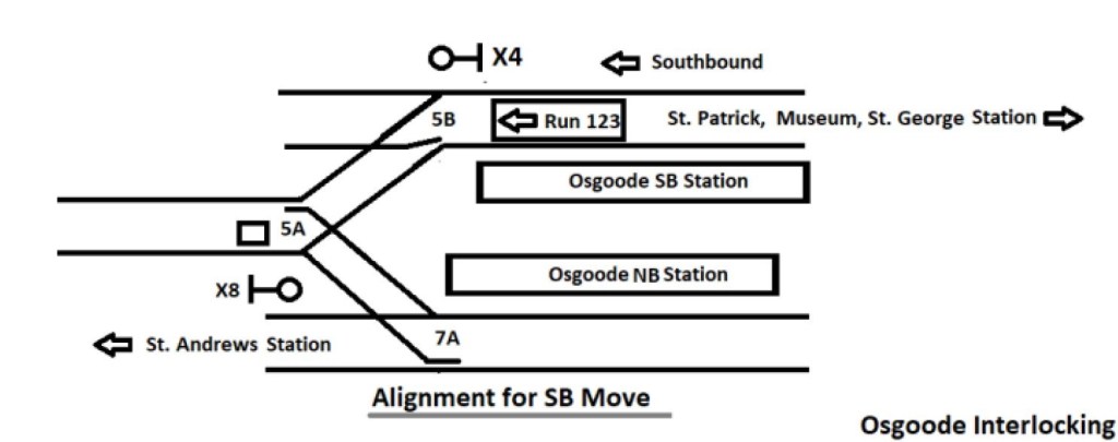
In a recent article Metrolinx Plans Major Grade Change on Lakeshore East Corridor I noted that a new set of drawings had appeared in the Ontario Line Neighbourhood Update, East web page showing a proposed change in the elevation of tracks in the shared GO/OL corridor between East Harbour and Gerrard Stations.
Here is a Metrolinx illustration showing the change. The layout as originally proposed is on top, and the revised layout is on the bottom. Note that where green space is shown neside the corridor, this does not necessarily exist as some of the Metrolinx property line is at or close to the sidewalk. The retaining wall plus noise barrier would be immediately adjacent.

I posed a series of questions to Metrolinx in an attempt to sort fact from fiction on this matter, and today had a call with their project staff to sort through the issues. The principal speakers for Metrolinx were Malcolm MacKay and Richard Tucker.
When was the decision made to regrade the rail corridor? Why is this being done?
According to Metrolinx, this has been underway for at least 6 months as a collaborative effort with the TTC and City of Toronto to establish bridge clearances and other design elements.
Substandard clearances are a concern on the road network for both the City and the TTC. Those of us who follow TTC service interruption reports often read of “mechanical problems” near Queen and DeGrassi Streets. These are almost always due to damaged or broken overhead thanks either to a dewirement, or to an over-height vehicle striking the TTC wires.
A related concern is that the bridges in this corridor are about a century old, and this is an opportunity to replace them with new structures that will have lower maintenance costs
Later in the conversation, I asked whether Metrolinx was saying, in effect, that “the City made us do it”. To this they responded strongly that they are not blaming the City, but there is a 5m standard for bridge clearances that they are following. They went on to say, possibly imprudently, that there were pro and anti camps on the question of whether this work should be done.
Obviously the pro camp won out, but drawings showing the change are quite recent, and there is no mention of this in all of the studies that have been published.
What is the extent of the work, i.e. between what locations will the track be raised from its current level?
From east of the Don River to Gerrard Street. According to Metrolinx, he TTC still has an interest in the Dundas Street bridge because they are protecting for an extension of streetcar service to Gerrard Station via Dundas and Carlaw.
By how much will the track be raised?
The change varies by location, but it will be between 900mm and 1500mm according to Metrolinx. For those who still think in Imperial measure, that’s just under 3 feet to just under 5 feet.
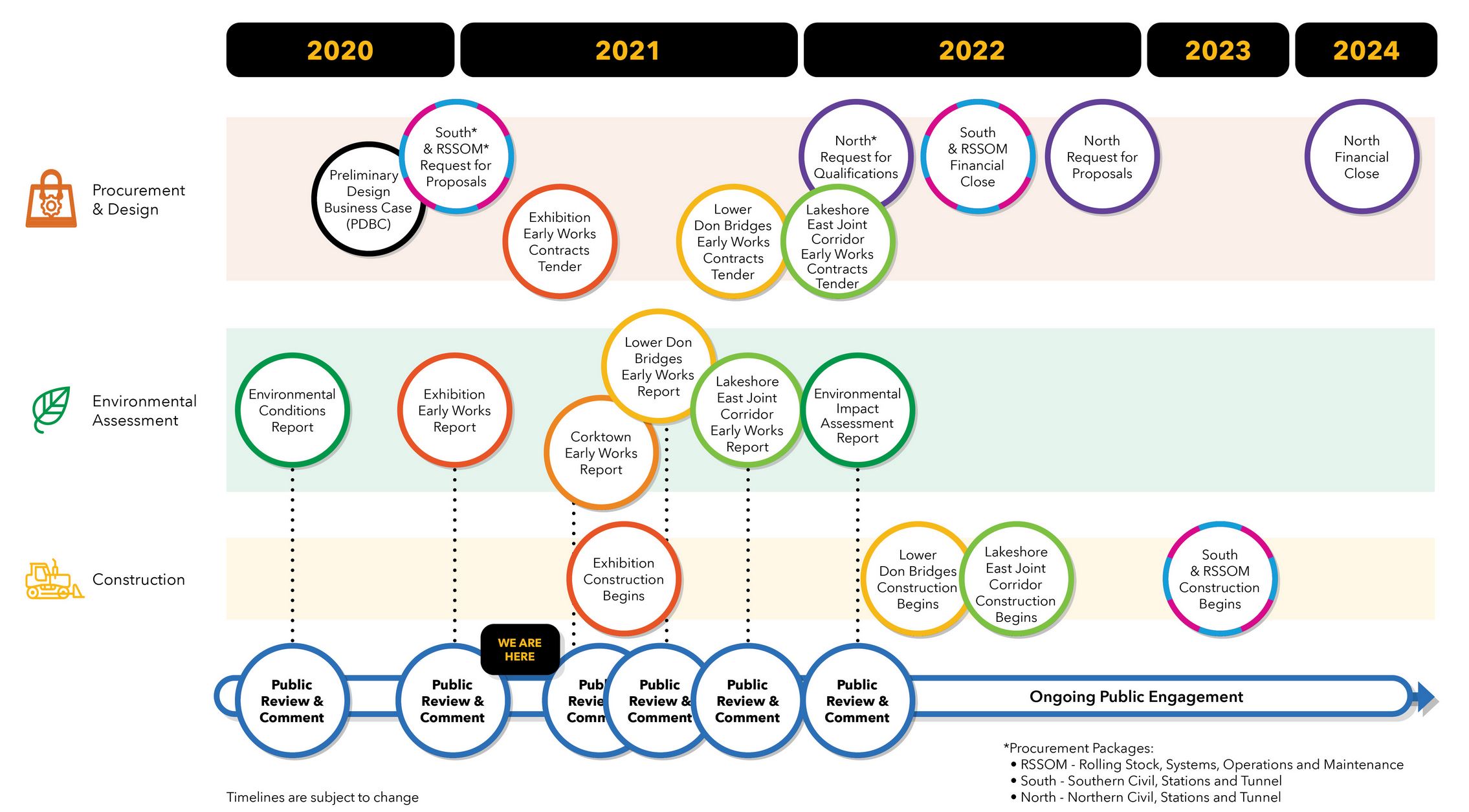
I asked whether a plan showing the new elevations exists in the style of “roll plans” that have been provided for other corridor projects. This will probably be published along with other details for the next round of public consultations later in 2021.
What are your staging plans for maintaining GO service during this work?
Metrolinx would likely slew the existing GO tracks to create work space on one side of the rail corridor at a time. This would allow all work to be done within the corridor rather than using adjacent spaces. Metrolinx’ property is wide enough for six tracks, and this means that three could be maintained in operation by shifting them to one side while work was done on the other side. There are no switches in this segment, and therefore shifting the tracks is relatively straightforward.
If low ridership on GO continues long enough, it might be possible to reduce the corridor temporarily to two tracks giving more room to work around the live operations.
What are the effects on the bridges in the affected area?
The bridges are old dating back to 1924. Metrolinx intends to replace them with new structures regardless of whether they are owned by the City or Metrolinx.
The elevation change will be entirely at Metrolinx track level. The road elevations will not change.
When I published my article, a few emails arrived suggesting what was behind this change. One claimed that the High Frequency Rail (HFR) project wanted a different track standard to support their planned operating speed. This seemed a bit far-fetched considering how close the tracks in question are to Union Station, and how short (2km) the segment is. The change in travel time from Toronto to Montreal would probably be measured in seconds.
Can you confirm or deny that at least part of the reason for the regrading is to suit HFR? If so, does the intent to use “tilting” trains change the spacing of the tracks needed for clearance?
Metrolinx replied that HFR did not play into decision making for rail heights or tilting trains. The alignment is designed to Metrolinx standards. They are not precluding HFR, but not changing bridges or track layout on HFR’s behalf.
A Question of Transparency
I will take it on faith that the City and TTC really have been working with Metrolinx for half a year on this matter, and that there may have been a debate about whether regrading the corridor and raising the bridges was actually necessary.
That said, Metrolinx published extensive studies and community presentations showing the corridor at its present elevation, and with no provision for the construction effects of rebuilding the segment from the Don River to Gerrard, not even a mention as a possibile subject for further study.
There has been no evaluation of the construction effects, and proposals regarding mitigation of the combined OL and GO effects here are based on current track elevations. This affects sound barrier heights and the amount of room available for corridor “softening” with treatments such as vegetated slopes or additional trees where room is available for them. The drawings purporting to show what the corridor would look like simply do not match what Metrolinx now plans to build.
All this is not to say that raising the corridor and improving clearances are, on their own, bad ideas. It would be refreshing to have fewer service interruptions on the streetcar network here, especially considering that over half of the fleet is based just east of this bridge at Leslie Barns and Russell Carhouse.
If this has been a City and TTC concern for months, why does the local Councillor not appear to know this could be part of the project scope?
Another obvious question must be what effect this will have on the project’s cost and duration. Who is picking up the tab?
One cannot help wondering whether it is only good fortune that this design change came to light during the current round of consultations.
What else don’t we know about Metrolinx’ intent in this and other corridors?
All of the debates about the project until now were based on a false presentation of how the enlarged use of the rail corridor would affect the neighbourhood.
This is not just a question of settling a debate among “the experts” about whether to raise the rail corridor or not. This is not a minor scope change. This is not an “oops”.
Even with the best of intentions, the basic issues are transparency in public consultation and trust in Metrolinx.