
Updated March 24, 2021 at 10:00 am: In response to feedback about my remarks regarding the area around the “Bridge” station on the new Metrolinx alignment, I have added a section at the and reviewing the Langstaff Gateway Plan.
On March 18, 2021, Metrolinx released their Initial Business Case for the Yonge North Subway Extension (YNSE) to Richmond Hill together with a refinement, a Supplementary Analysis of their preferred option. There is also a short presentation deck on this subject on the agenda for the Metrolinx Board Meeting of March 25, 2021.
The IBC was originally completed in mid-2020 but it has not been public until now. Some aspects of it were reported at the time in the Toronto Star. (The report appears in the meeting agenda for September 10, 2020 in the private session.)
Updated March 21, 2021 at 9:20 am: A reference page linking to YNSE reports has been added for those interested in the proposal’s history.
The project chronology shows how long this extension has been in various planning stages. The Metrolinx Benefits Case Analysis was published over a decade ago in 2009, and it was updated in 2013. Options studied at the time had more to do with staging than with alignment choices:
- Option 1: A six stop extension from Finch Station to Richmond Hill Centre with intermediate stations at Cummer, Steeles, Clark, Royal Orchard and Langstaff.
- Option 2: A phased extension first to Steeles including Cummer Station, with the segment north to Richmond Hill to follow.
- Option 2A: In addition to the shorter subway extension, service on the GO Richmond Hill line would be improved to every 20 minutes in the peak period.
Regional growth plans tilted the preference to Option 1 as a way to support a node in Richmond Hill.
The fundamental problem which the IBC and its supplement seek to address is that the cost of the extension had grown to $9 billion in 2019 from an original estimate in the 2007 approved plan of less than $3 billion. The project was taken over by the province as part of its rapid transit upload after preliminary design and engineering by TTC and YRRTC (York Region’s rapid transit agency) showed a substantial increase in the cost.
Part, but certainly not all, of that change is explained by inflation, and one must wonder whether the original estimate was low-balled to gain approval for a project with political appeal in York Region. Another problem is that “cost” is reported in different ways by municipal and provincial planners, and it is not clear that all of the increase is on an apples-to-apples comparative basis.
In the June 2020 IBC, Metrolinx evaluated three options as shown on the map below.
- Option 1 (turquoise) is the original alignment that follows Yonge Street to a station at Langstaff, and then swings east to a terminal at Richmond Hill Centre.
- Option 2 (blue) includes a new stop “Bridge-West” at Highway 407 and a station at High Tech Road.
- Option 3 (pink) turns off of Yonge at Kirk Drive, cuts under the Holy Cross Cemetery and follows the CN Bala Subdivision with stations at “Bridge-Centre” and an High Tech Road. This was the preferred alignment in the IBC.

Here is a closer view of the north end of the line showing all three options.

Option 3 shown in pink above is the preferred one for reasons I will describe below, but there were concerns that it cut under the corner of Holy Cross Cemetery. This led to the alignment proposed in the Supplementary Analysis.
At the Don River crossing, the revised alignment swings west and then turns east following a route to the CN Bala Subdivision (GO’s Richmond Hill corridor) further south than in the original Option 3 shown above. The subway runs under the CN corridor where it passes under the cemetery, and then surfaces to run alongside the railway tracks.
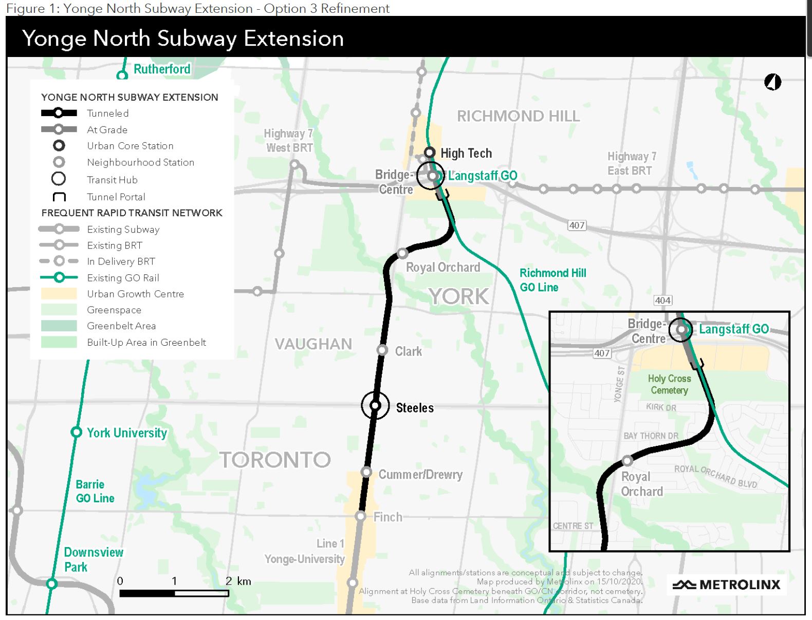
Another major change in the design is that some stations have vanished, although depending on how the budget works out, they could gain a reprieve. The affected stops are Cummer/Drewry, Clark and Royal Orchard.
How Did Metrolinx Save So Much?
I asked Metrolinx how there could be such a large-scale change in the cost estimate from $9 billion down to $5.6 billion. They replied:
One of the primary reasons staff were able to reduce costs was by limiting the amount of excavation required for tunnels and stations. This is achieved by taking the northern segment of the alignment east of Yonge Street to meet the CN rail corridor, allowing the tracks to rise to the surface and run at grade, instead of underground.
The previous proposal also called for an underground train storage facility near the end of the extension, along with a bus terminal at Steeles station that was planned be built below the ground. Our design and planning teams determined that placing these facilities at ground level will significantly reduce costs while maintaining important benefits of the project.
Placing the train storage facility at surface level brings the proposal in line with the TTC’s five subway train maintenance and storage facilities, which are also above ground. This approach is common for transit support facilities all over the world. Cities like Vancouver, Chicago, and New York all have ground level train storage facilities that successfully integrate into residential areas while meeting the needs of their transit networks.
Source: Email from Scott Money, Metrolinx Media Relations, March 19, 2021
A saving of over one third is a substantial change. All together this involves:
- Surface construction from Holy Cross Cemetery northward including the new rail yard in Richmond Hill that was formerly underground
- Replacement of a very large underground bus interchange at Steeles Station with a surface facility that will be integrated into new development
- Deletion of three stations
Another change between the 2007 plan and the 2020 IBC is that originally the line was to cross the Don River on a double-deck bridge with Yonge Street on the upper level. This has been changed to a tunnel under the river. There is no discussion of how this might have affected the line’s cost.
The new alignment requires the line to shift west of Yonge at the river crossing and this affects the viability of a shared bridge. Moreover, continuous tunneling under the river avoids the need for separate tunnel boring launch sites for the north and south segment, offset by the effects of a deeper route. (Metrolinx has not yet replied to my question on this matter.)
Between the IBC and the Supplementary Analysis, the infrastructure cost estimate was further reduced. This gives headroom for one of the comparatively minor stations on the route to be restored.
Stations and Demand
The stations generally are referred to as three types:
- Primary Stations: Steeles, Richmond Hill Centre (option 1) and Bridge (options 2-3) are “primary” stations because they are major transfer points for surface bus routes and demand at them is strong,
- Cummer, Clark and Royal Orchard are “neighbourhood” stations.
- Langstaff (option 1) and High Tech (options 2-3) stations are classed as “complementary urban core stations” because of their role in supporting development.
A major function of Steeles Station is to intercept a very large flow of passengers, primarily on TTC routes like 60 Steeles West and 53 Steeles East (and their express counterparts) before they reach Finch Station. About 9,400 passengers are expected to transfer between bus and subway at this station.
The original plan had a huge underground bus loop running along Steeles Avenue (think Lawrence Station on steroids). This has been shifted to the surface at substantial cost saving, and will probably be incorporated in a planned development.
The Board presentation deck includes the following comment about Steeles Station:
Steeles Station will be a hub for local bus routes as well as a future rapid transit line along Steeles Avenue.
Presentation deck: P. 3
I asked Metrolinx what this meant, but they were unable to explain.
The “neighbourhood” stations were the first to go as a potential cost saving. Their projected demand is low enough that they actually have difficulty making a “business case” on their own because they depend entirely on local traffic. This begs the future of rapid transit stations anywhere other than regional interchanges and development nodes and could have implications for future rapid transit proposals.
A related problem is that much discussion about the “right” way to build transit depends on density at stations as opposed to within the catchment area of feeder routes. It is ironic that the most important stations on this extension depend primarily on feeder buses and (in the case of Langstaff Station) commuter parking for their demand.
The projected AM peak hour demand for stations in each option is shown below:

The importance of bus transfer traffic is shown below. Note that these are all day figures while the counts above are for the AM peak hour. The term “BAU” refers to “Business As Usual”, that is to say, the demand if the extension were not built. The huge numbers at Finch reflect the volume of feeder bus service needed to bring all of these riders to the terminal. (Note that this includes riders transferring from the Finch bus services who will not shift to stations further north.)
The IBC notes that strong ridership for Option 1 depends on riders from the proposed parking at Langstaff Station.
Langstaff Station is proposed to include a commuter parking lot facility. This lot is located on the Hydro lands to the southwest quadrant of Yonge Street and Highway 407. Options 2 and 3 assume that there would be no commuter lot for the northern stations in the ridership model. The modelling results suggest that there is a demand for park-and-ride access. The difference in transfers for the northern stations noted above is partially attributable to this availability of parking, resulting in less need for bus transfers when compared to Option 2 and Option 3. The impact of parking will be reviewed in more depth through the Preliminary Design Business Case.
IBC: P. 99
I asked Metrolinx if they had demand breakdowns by mode for all stations, a reasonable question considering that specifics for bus transfer and walk in traffic are cited for some stations. Metrolinx replied:
The next stage in planning for the Yonge North Subway Extension includes the release of the Preliminary Design Business Case (PDBC), which will further refine the project’s design, alignment, and benefits. Parking will be evaluated in more depth through the release of the PDBC.
Email from Scott Money, Metrolinx Media Relations, March 19, 2021
A deeply troubling set of numbers in the projections is the transit mode share in the Yonge Street corridor. Although the YNSE will carry somewhat more riders than the buses do today, the mode share will shift by less than one percent. Overall, transit will carry only about one fifth of the total demand in the corridor.

This says something about the overall attractiveness of transit and the degree to which it will actually support growth in the region.
A further problem lies with the low number of new transit riders who will be attracted to the line. This has compounding effects through the evaluation including:
- Marginal revenue from the extension depends on new riders who will pay subway fares that the TTC is now not receiving. If most riders are already on the system, there is little new revenue to offset operating costs of the subway. This is the situation with the Vaughan extension where most of the riding is not “net new” to the TTC even though the subway’s operating cost is almost entirely on the TTC’s shoulders, not York Region’s.
- Any benefits ascribed to reduction of car travel (reduced pollution, less congestion, fewer accidents) depend on actually shifting people out of cars. Riders who are already on buses will not contribute to this shift. This is separate from the fundamental problem that any capacity released by an auto-to-transit shift will backfill due to latent demand and there will be no real saving on the environmental account. If anything, the removal of large number of buses from the corridor might encourage additional auto traffic.
- It is self-evident that if most riders are already using transit, they do not represent new residents or workers in planned developments. This begs the question of whose demand projections and land use projections should be believed. York Region’s projections are somewhat higher than the Metrolinx numbers. This problem is common to new nodes that are served by a major transit corridor from only one direction. Many who will commute in do not live in the subway’s catchment area, and those who will commute out might well work east, west or north of Richmond Hill where the subway does not go.

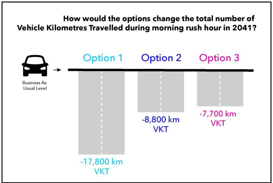
The change in Vehicle Kilometres Travelled (VKT) is shown below. This is trivial compared to overall vehicle mileage in the region, and is a direct result of the relatively low number of net new transit trips. Note also that Option 3, with its absence of parking, produces the least change in vehicle use.
One option that Metrolinx never studies in this context is the possible benefit of substantial investment in local transit service. How many more riders might the subway get (together with the benefit of avoided auto travel) if only local service were substantially improved?
Where is GO Transit?
When the Richmond Hill subway was evaluated back in 2007, the only option that included an “improvement” on GO rail service had two components — a BRT operation on Yonge Street, and a 20-minute service of GO trains. The BRT service was unable to handle projected demand, and the trains, needless to say, did not attract many riders on that headway.
Metrolinx often complains that the Richmond Hill corridor would be expensive to upgrade, and that there are issues for the portion of the corridor owned by CNR, but there has never been a comparison of the cost of more frequent service beyond what can be shoe-horned into the existing track.
The IBC suggests that Metrolinx has given up on the corridor:
It has been noted that the GO Rail system does not serve all parts of the Greater Toronto Area, nor does it serve many shorter distance trips. The GO Richmond Hill Corridor currently provides service to central York Region, but is not part of the GO Expansion program that is being implemented on some other GO Rail corridors. As a result, Metrolinx is also working to implement other rapid transit investments to address the needs of the Greater Toronto Region. The YNSE project extends rapid transit service to other municipalities in the Region and provides a connection between destinations in these municipalities with destinations in Toronto.
IBC, p. 22
An important issue here is that everybody in Richmond Hill does not want to travel to Union Station, and anyone bound for intermediate centres at North York, Eglinton or Bloor will have a faster trip just staying on the Yonge subway. However, the Richmond Hill line also intercepts major east-west routes notably on Steeles and Finch and could attract riders who would otherwise go to the core via Line 1.
Another important selling point for the subway extension is that if you work or live near it, you can travel for a TTC fare across the 905/416 boundary. The fare boundary skews the political debate in favour of the subway.
The dual challenges here are the frequency of GO service (and the extra trip time needed to transfer) and the lack of an intergrated GO/TTC fare. The modelling conducted in the IBC assumes the existing 905+GO fare arrangements, but only a flat GO fare within Toronto and no free transfers to or from the TTC. Needless to say, this drives ridership to the existing TTC network rather than providing relief. (There was a similar problem with modelling SmartTrack and the Scarborough Subway where frequent service and full transfer privileges between ST and TTC were essential in attracting riding to that line with the subway sitting not far away.)
The ability of the Richmond Hill corridor to provide subway relief is key in another context: the Yonge subway will be full again within two decades.
The IBC makes an odd comment in evaluation of the extension’s effects on subway congestion:
Through ridership analysis, it has been determined that new ridership associated with the extension would have a small impact on Line 1 crowding, partly because the line is close to capacity. Preliminary analysis suggests that the extension is expected to increase crowding south of Bloor station by around 1% (assuming Ontario Line will also have been in service by 2041). Many of these impacts would not be felt on the YNSE but would impact downstream passengers north of Bloor-Yonge who would experience more crowded trains and delays in boarding than would occur without the extension.
IBC, p. 93
In other words, the extension will not make the subway much more crowded because the line will already be close to capacity in 2041. I asked Metrolinx about this, and they replied:
The extension won’t come online until the Ontario Line goes into service, which will significantly reduce crowding on Line 1.
The Yonge North Subway Extension is also one of four projects under the Subway Program that are designed to spread demand across the transit network as it expands.
Email from Scott Money, Metrolinx Media Relations, March 19, 2021
No, I’m sorry, that’s not what the IBC says. It is quite clear that Line 1 will be at capacity ten years after the Ontario Line, which is part of the demand model’s network, will open in about 2030. There may be “relief” at that point, but not ten years later. Spreading demand across the network will require even more investment including projects such as taking the Ontario Line north to at least Sheppard, improving service in the Richmond Hill GO corridor, and making GO within Toronto (at least) part of the “local” fare structure and transfer scheme.
The Importance of Development
Many aspects of the proposed line are tied to the stimulus this can bring to development north and south of Highway 407. This shows up in various ways.
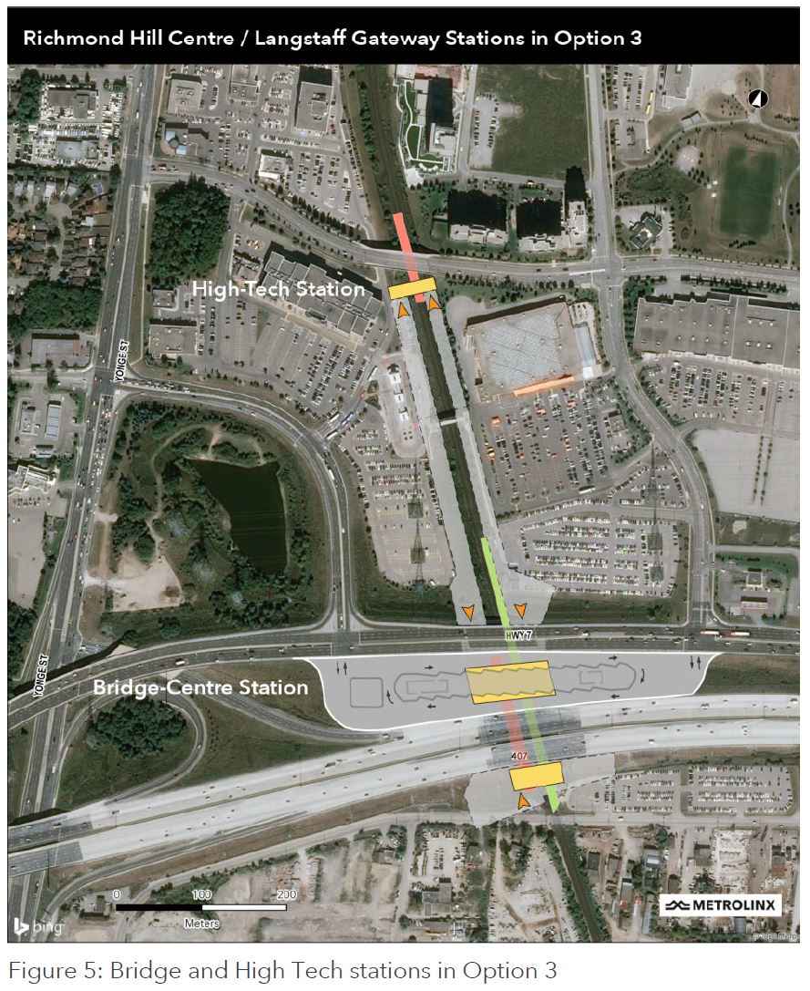
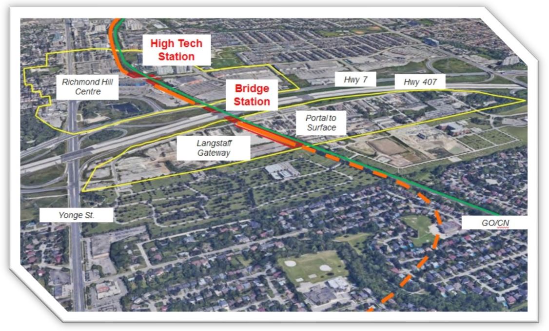
Option 3 moves the subway structure hard against the rail corridor. The “High Tech” station together with the structure of “Bridge Station” place several station entrances in locations to maximize short walking connections to the subway while leaving land west of the rail corridor open for development. Here are two views of how the alignment and stations work.
The first is a direct overhead satellite view. The area is challenging for pedestrians because of the rail corridor and highway nature of various roads. The prevalence of parking lots is particularly troubling, although redevelopment could replace or incorporate them. The question here will be whether development will occur in a way that is pedestrian friendly, and how well (or not) it will pull in adjacent areas. There is a large bus interchange at Bridge Station, but this is isolated by the highways.
The station will feature significant bus facilities to serve Regional GO Bus Routes, and local York Region Transit routes. An advantage of the Bridge station location is the opportunity to integrate the frequent VIVA BRT routes into the terminal design, optimizing the connection between higher order transit modes. The Bridge concept puts not only the subway at the connection point of the two development areas, but it puts the full transit hub at the same location. Residents on both sides of the highway corridor have access to local and regional buses serving York Region and the wider Greater Toronto Area.
IBC: P. 37
A key point here is that there have to be residents on either side of the highway corridor to take advantage of this access.
The description of High Tech Station is even more breathless in its hopes for development.
A second station would recognize the vision of the provincially designated Urban Growth Centre as having a truly regional impact on the Greater Toronto Area. It would put platform access for new residents in Richmond Hill Centre within a highly desirable 5-minute walk. For employers and their employees, it would replicate similar transit supportive conditions seen in Downtown, Midtown and North York Centre where office complexes have a quick direct connection with the subway. Municipal planning staff have highlighted that this type of access is attractive to developers, employers and future employees.
IBC: P. 38
A distinction about the “transit supportive conditions” further south is that there was already a city there before these nodes developed. It is not just a subway station or two that makes a site attractive, but being in the middle of a dense city. York Region has more aggressive assumptions about commercial development in this area than Metrolinx used in its projections.
This view is from the south showing the subway heading east from Yonge Street to the rail corridor and heading north.
Another view of the station areas appears in walking distance profiles for the pair of stations. Bridge Station makes a large area south of Highway 407 accessible, but this land is now either vacant or occupied by industrial uses. Will it fill with the type of high density Metrolinx dreams of for stations, or as a continuation of the low-rise built form further south? There are no walkable neighbourhood services, and the site shares with so many GO stations the problem of being in the middle of nowhere.
Take a walk around the “neighbourhood” south of the 407 with Google Street View. This wasteland is an “Urban Growth Centre” that becomes a lot more valuable now that it will have a subway station “bridging” the otherwise impenetrable 407. There is already a sign on one of the fences advertising an application for a plan of subdivision. The subway will not arrive for a decade, and by the time it does, this will probably be more low-rise suburban housing, not the “transit oriented development” Metrolinx touts.
It is quite clear that Option 3 is preferred because it provides both a development node and a regional bus terminal. How much benefit this is beyond the immediate area is another matter. “Walkability” after all requires not just a path and a time contour, but a “here” and “there” to make the walk worthwhile particularly in poor weather.
At the risk of sounding like a hopelessly narcissistic “downtowner”, I am not convinced that this station pair will create a “downtown Richmond Hill” as opposed to a free-standing, wanna-be node whose primary attraction will be a subway on which anyone there can escape to somewhere else. I cannot help thinking of Scarborough Town Centre whose location was dictated by a developer’s land holdings, and which took decades after the SRT’s opening to become much more than a shopping mall in the middle of a parking lot.

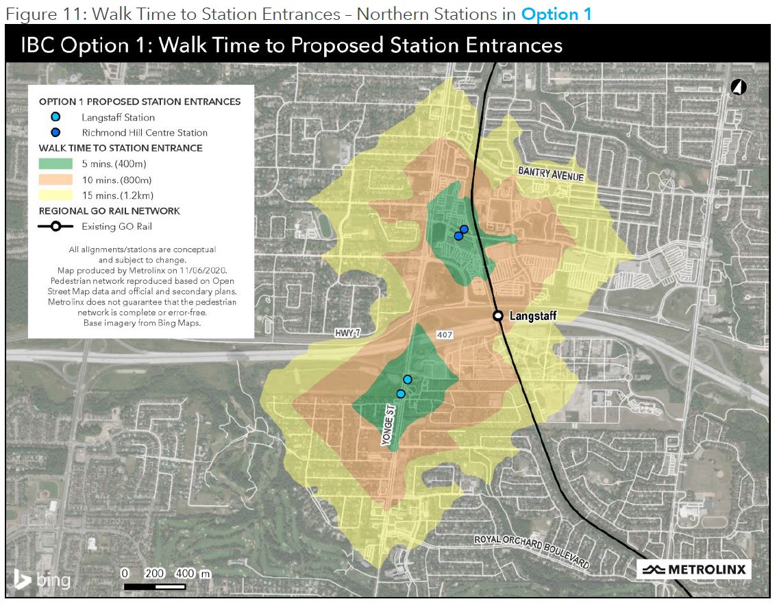
The next figure shows the walking distance profile for the original Option 1 alignment with stations at Langstaff and Richmond Hill Centre. Because the stations are further apart, the walking area stretches over a wider area, although those paths that would require crossing major roads are unlikely to be attractive. This arrangement also leaves the GO station remote from the subway and provides poor connectivity with bus services on the 407.
The degree to which neighbourhood stations serve little function beyond their immediate vicinity is illustrated in this discussion of Royal Orchard Station.
Royal Orchard station is positioned to break up what would be a significant gap of between 2.5 and 3.5km between Clark Station and Langstaff/Bridge Station. The analysis indicate that Royal Orchard Station will serve walk-in customers accessing the subway during peak hours. Passengers accessing the subway by bus will have the option to get on the subway at other stations. The 800m catchment area of this station would only have a minimal overlap with the Langstaff Station in Option 1. If a Royal Orchard Station was added, almost all the people and jobs in this area would be able to walk to the subway at an earlier station; and therefore, they would save time on their trips to Toronto. In Option 1, this station would benefit about 70% of people and jobs that are outside of the overlap with the catchment area of Langstaff Station.
IBC: P. 95
Why Option 3?
I asked Metrolinx why Option 3 was chosen even though it has the lowest projected demand. They replied:
This option has potential to provide the most number of stations within the $5.6 billion funding envelope. In order for Option 1 or Option 2 to be delivered within that funding envelope, the final project would be limited to three stations. A route that goes to ground level, aligning with the existing CN rail corridor, gives the flexibility needed to include a fourth station.
It is important to recognize that there are a wider range of factors that are considered as part of the final decision-making process. The Metrolinx business case is just one of several factors that is used in making a final decision.
Our approach in preparing business cases is to err on the side of caution, so this analysis represents a purposefully modest baseline that we will aim to improve over time.
Extending subway service through Vaughan, Markham and Richmond Hill will bring a world-class level of convenience and a better quality of life to the communities it serves. It will provide faster, easier access to downtown Toronto, York Region and all points in between.
We know that higher-order transit like this is transformative in so many ways. The Yonge North Subway Extension will expand travel options along York Region’s VIVA bus rapid transit lines and provide more Line 1 subway riders with a seamless journey. These benefits will also provide better access to jobs and offset traffic congestion as drivers get out from behind the wheel in favour of using the subway.
Any assessment presented in a business case represents our best understanding of a project at a given point in time, and it can change throughout a project’s lifecycle based on external factors and a deeper understanding of the challenges and opportunities.
We use the data from our business cases to ensure we make decisions that maximize benefits and control costs throughout the full course of a project. We update the business case at key stages to ensure these benefits are realized.
Email from Scott Money, Metrolinx Media Relations, March 19, 2021
The “faster, easier access to downtown Toronto” is likely most important to people living in Richmond Hill especially in the developing area along Yonge Street north of the subway terminal. This is well outside the walkable territory of the stations, and they will depend on buses to connect with the subway. Whether commercial buildings sprout here is another matter. They would be essential for counter-peak traffic, but the location is relatively isolated.
Forecasts envision that these communities might grow to provide homes for more than 64,000 residents and might offer employment to more than 36,000 employees. As important as these raw numbers are, equally important is the shared vision for new urbanized core in the centre of the Greater Toronto Area.
…
Through the conceptual design development process, an opportunity to “bridge” the two communities with transit was contemplated. A common subway station facility could stitch together Richmond Hill Centre and Langstaff Gateway and optimizes transit service to these important destinations.
IBC: P. 37
The operative word here is “might”. The projected population density map shows where York Region expects development to occur relative to the stations.

The projection of jobs near the rapid transit stations echoes the pattern of other comparisons between the options with Option 3 performing lower than Options 1 and 2.

There is a lot of employment along the highway corridor, but it lies well away from the subway stations and will depend on connecting bus services. For many who work there, it is not clear that the subway will be much use at all depending on their home locations. Metrolinx planners fail to acknowledge that transit riders do not travel the same way as motorists, and the concept of “nearby” has much more to do with connecting transit service and short convenient walks than physical distance from origin to destination.
The vision for the Richmond Hill/Langstaff Gateway Urban Growth Centre is that these two parts of the UGC will become vibrant mixed-use communities with significant employment opportunities. This IBC acknowledges the importance of supporting this vision and ensuring that it is supported by the transit investment.
Areas with high levels of employment density near the YNSE are also highlighted on the map. Employment centres at Leslie and Highway 7 and Highway 404 and Steeles are evident on the map and are located just 4km and 6km east of new YNSE subway stations. The Promenade Mall located just 2km west of the Yonge Street corridor also shows higher employment densities.
New employment along and in proximity to the corridor has the potential to take advantage of the capacity that is available on the non-peak direction.
IBC: P. 64
Of particular note in this map is the employment concentration around the junction of highways 7 and 404. This is an established node that competes with Richmond Hill Centre and will continue to depend greatly on auto access. It is ironic that the rail scheme that became SmartTrack aimed to somehow deliver workers to this area from the GO Stouffville corridor which is as far east of the 7/404 interchange as Yonge Street and the proposed subway is to the west.

Service Design, Capacity and Fleet
The planned peak service on Line 1 and its extension will be:
- From Finch Station southward: every 105 seconds (34.3 trains/hour)
- Between Richmond Hill and Finch: every 210 seconds (17.1 trains/hour)
- (Pre-pandemic service operated every 141 seconds, or 25.5 trains/hour)
With a train capacity for planning purposes of 1,100, this translates to almost 19k passengers per hour north of Finch Station.
In the original plans for the YNSE, the TTC claimed a possible headway of 90 seconds (40 trains/hour). This cannot be achieved because of various constraints including terminal geometry, turnaround times and station capacities. That 90 second fantasy was one reason the TTC formerly downplayed the need for the Relief Line claiming that they could substantially increase service on the Yonge line. “Why would you build a new line when you can carry the demand on the line you already have” was how a former Chief General Manager put it to me.
The pre-pandemic schedule for Line 1 required 61 AM peak and 63 PM peak trains plus gap trains. There will be some reduction in these numbers when Automatic Train Control (ATC) is implemented over the full line. Moving to a 105 second headway requires about one third more trains, and so the base part of Line 1 will need about 20 more trains plus spares, less whatever is saved from ATC. This is not part of the extension’s project budget and is an unfunded item in TTC’s capital plans.
Travel time on the extension is about 12 minutes each way, or 24 minutes in total. At a 210 second headway, this requires about 7 trains plus spares. The project budget includes 12 trains as well as a 12-train storage and light maintenance yard north of High Tech Station extending along the rail corridor to 16th Avenue.
The IBC notes that there is provision for further extension for “revenue or non-revenue purposes”. I have asked Metrolinx what this means, and it has long been rumoured that the TTC has its eye on property for a major new yard in that location. This is not part of any capital plan.
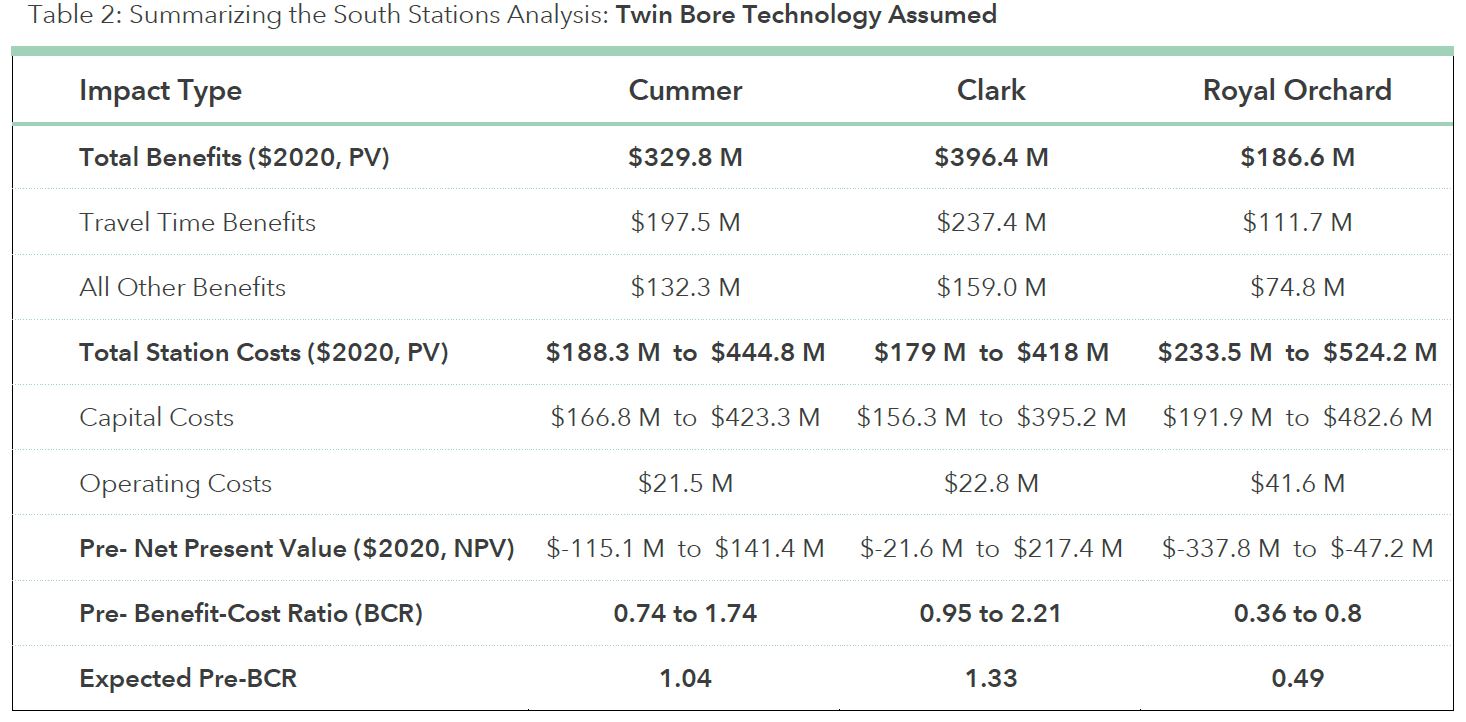
Station Costs
An important incentive for cost cutting is the ability to squeeze more stations into the capital budget. Below is a table for the three “neighbourhood” stations. In this table, the “benefits” are the imputed value of travel time and other savings (such as avoided auto trips) that could offset the cost of the station. However, there is a wide range of estimates for station costs ranging over a factor of about 2.5:1. On the basis of this evaluation, benefits that cannot be captured and monetized to pay for the stations are essential to making them “break even” as investments, and then only if the cost can be kept to the low end of the range.
I asked Metrolinx about this, and they replied:
With the completion of the Initial Business Case, we’ll now begin to confirm the benefits, financing, and delivery plans for procurement through the Preliminary Design Business Case (PDBC). The development of the PDBC is expected to take place over spring-summer 2021, with a target for fall 2021.
Email from Scott Money, Metrolinx Media Relations, March 19, 2021
This is all very well, but it raises a more general problem that “neighbourhood” stations may be on the verge of being unaffordable, and even that requires a belief in the notional value of benefits that accrue to riders and society as a whole, but which cannot be monetized to pay for infrastructure and operations. This also shows the amount of revenue that would be needed from joint development of station sites to make a significant dent in costs.
Capital and Operating Costs
There are two versions of the capital cost estimates: one is in the June 2020 IBC and the other in the Supplementary Analysis of March 2021.
Here is the original version:
And here is the revised one. Note that they are not on the same basis.
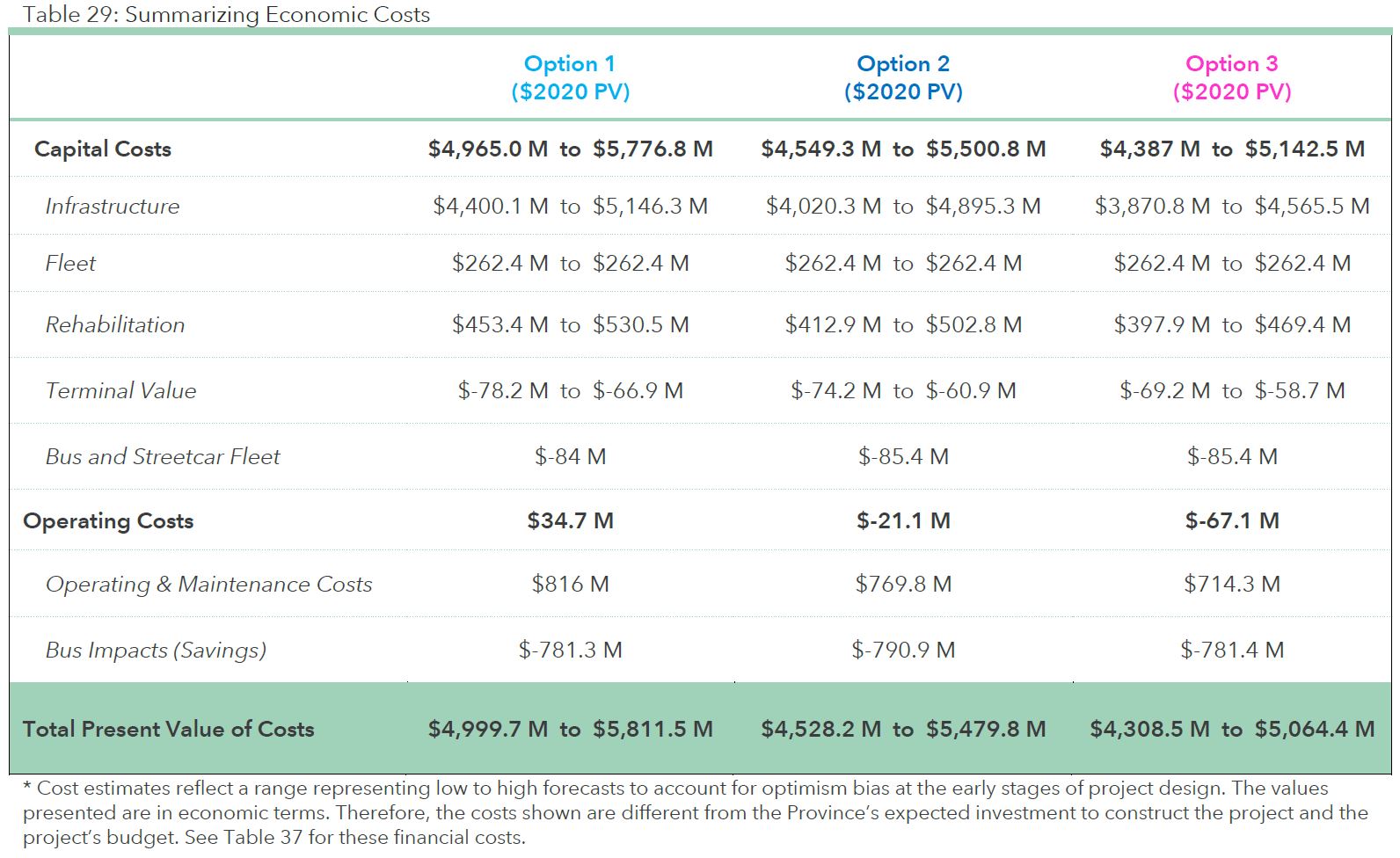
The reason that the Operating and Maintenance costs line is negative is that the savings from replaced bus service exceeds the O&M cost for the subway as shown in Table 29. This is an extremely unusual situation that applies only because Yonge Street is such a busy corridor.
Note that the “user impacts” constitute almost all of the “benefits”, and even so, the calculated Benefit-Cost Ratio (BCR) is less than one indicating that, under these assumptions and values, the investment does not “pay for itself” over a 70 year lifespan.
The capital costs for the three options in the original plan are shown below on an undiscounted basis (future costs such as replacement of subway cars and escalators when they wear out are not stated in 2020 dollars). In this version, the Infrastructure line consumed all of the $5.6 billion the province had allocated for it. There is a further $1.4 billion (net) bringing the total to $7 billion, and there is no indication of how this will be funded.
Moreover, without a comparison calculation of the $9 billion alleged cost before the provincial takeover, it is not clear exactly what the basis of comparison might be.
A major problem with Metrolinx cost estimates is that they mingle the short-term cost of construction with longer term costs, revenues and benefits. This masks the fact that any project of this scale is front-end loaded with construction costs whether this is masked under government borrowing or a long-term P3 financing arrangement.
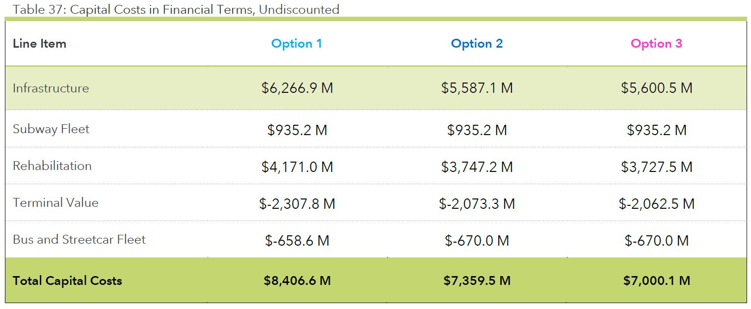
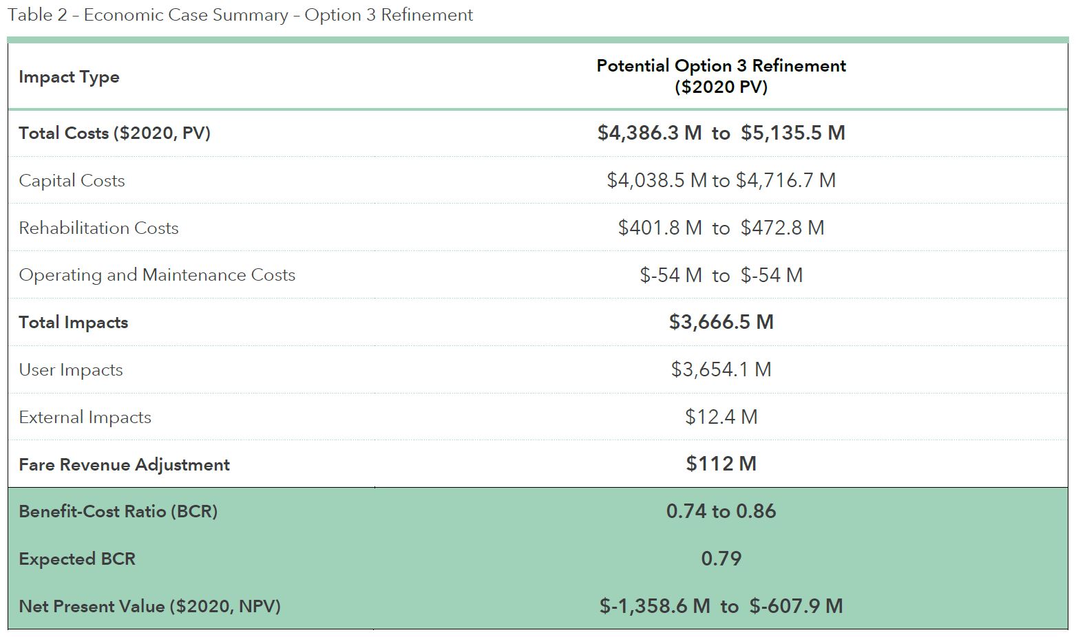
The capital cost shown in the “refined Option 3” projection is lower than the numbers above, but again it is presented in a different way making a direct comparison difficult. The saving claimed in this update creates the headroom for a possible additional station.
Funding and Sharing the Costs
The IBC as well as government statements make clear that Ontario seeks contributions from other levels of government to this (among other) subway project.
The provincial government expects the YNSE to cost an estimated $5.6 billion in capital expenditure. The province is committed to ensuring all three parties (i.e. federal government, the province and municipalities) contribute to the funding of this essential transit infrastructure projects as well as seeking other third party funding for stations.
Through the Preliminary Agreement, the province and York Region will work closely and collaboratively to develop an approach to funding measures that works for all parties. Part of this work includes a comprehensive financial review and due diligence exercise to explore potential revenue raising measures, which will be subject to future decision-making. Such an exercise will be narrowly scoped, focusing specifically on the YNSE and the future benefits that the project is expected to generate.…
The TTC will be the operator of the YNSE and will incur the operating costs. The fare revenue identified can offset the operating costs, alongside York Region providing an operating contribution. Details of these arrangements remain to be resolved. This important piece of work will be facilitated by the impacted stakeholders.
IBC: P. 131
The nature of York Region’s contribution to the capital and operating costs remains to be seen. Toronto currently subsidizes at roughly $12 million annually the Vaughan extension’s operation north of Steeles (Pioneer Village Station). The model for the YNSE will see Toronto assume the operating cost in exchange for fare revenue, but the large majority of riders will already be paying TTC fares and they represent no net gain. Meanwhile the cost of carrying them through York Region and down to Finch Station will come off of the Region’s books.
I asked if Ontario had specific contribution levels in mind. Metrolinx replied:
The 2019 provincial budget estimates capital costs for the Yonge North Subway Extension to be $5.6 billion.
Metrolinx and Infrastructure Ontario are moving the project forward under the Subway Program, which includes three other rapid transit expansions that will get the region moving — the Ontario Line, the Eglinton Crosstown West Extension, and the Scarborough Subway Extension.
The provincial government has committed $11.2 billion toward the Subways Program, as a whole.
York Region has pledged to contribute proportional funding to the capital construction costs of the project through a preliminary agreement with the provincial government. The final contribution from the region will be subject to further refinements to the project’s budget and scope.
The Government of Ontario is also seeking contributions from the federal government.
Email from Scott Money, Metrolinx Media Relations, March 19, 2021
With respect to any federal contribution, a major issue is that the recently announced federal program of $14.9 billion nationally over 8 years does not leave a lot of money on the table for the GTA. It is not clear whether any separate monies are or will be available outside of this allocation to pay for a federal share of Ontario’s four key projects. If Ontario expects to get 40 per cent of the YNSE’s cost from the feds, this would take $2.24 billion out of the allocation.
A large chunk of that money has been proposed as support for electrification and the replacement of diesel buses with battery electric vehicles. It might be argued that a subway extension that replaces thousands of bus trips would accomplish the same thing, but (a) that ignores the energy and carbon effects of subway construction and (b) is probably not what those looking forward to cleaner bus service had in mind.
Soft Benefits
Metrolinx cost analyses trades off capital and operating costs against various benefits including:
- the imputed value of travel time saving
- reduced vehicle operating expenses
- reduced congestion
- reduced pollution and health effects
Based on a 2020 review of approximately 70 business case options, it is estimated that travel time savings captures approximately 60 percent of overall benefits.
IBC: P. 146
This is a telling statement. The majority of the benefit from various transit projects appears in the travel time savings, a value that cannot be monetized nor can it be applied to offset real capital and operating spending. Moreover, for a net new resident of the area, there is no “before” expense to be saved, only an “after move in” expense to be avoided.
Transit building also makes land more valuable, but none of this is captured in the model either through value uplift capture (a tax on capital gain) or through a tax on the higher revenue a property can generate thanks to a nearby public investment. Municipalities are quick to point out that higher taxes from new development go to pay for basic services needed by new residents, workers and employers. They are not just sitting on the table waiting to finance transit projects.
There is some offset from Development Charges, but even these are under attack by the development industry and their friends at Queens Park. DCs can only be levied to cover the cost of infrastructure upgrades triggered by new builds, not on the portion of cost increases related to providing better service and faster rides to existing passengers. With the low proportion of net new riders, DCs will not apply to a sizeable chunk of the extension’s capital cost.
Reduced congestion is given a nominal value by Metrolinx, as are assumed reductions in pollution and the health effects of autos. There are two fundamental problems here:
- All roads now operate at or over capacity, and with the relatively light diversion of trips to transit, this will not change. Indeed, a massive shift would be required just to overcome latent demand for the 80 per cent of trips that will still not be on transit.
- If there is a large-scale shift to pollution free vehicles, the savings on that account will dwindle as the fleet mix changes from internal combustion to electric.
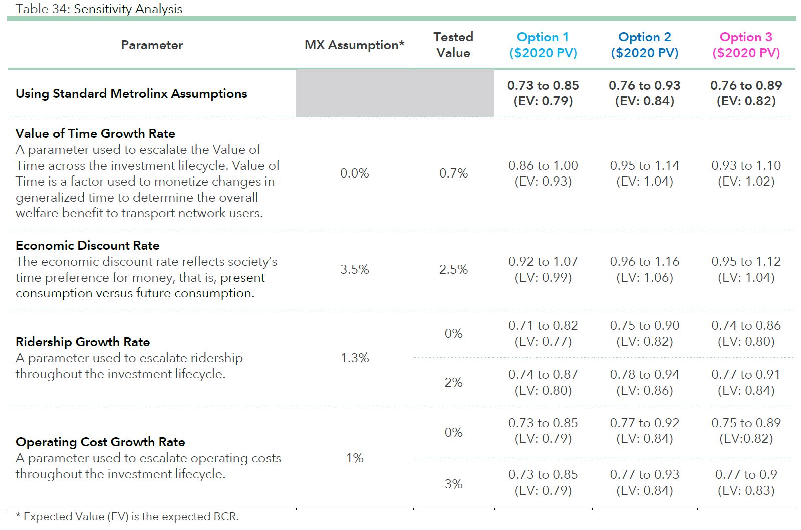
Metrolinx discounts future benefits for the 70 years after a line opens back to present value. This has the effect of “paying for” current capital expense with notional future savings discounted for inflationary effects. If the discount factor is adjusted, the value of those future savings can rise or fall, and in some cases move a proposal from a negative to a positive overall analysis. This is illustrated in Table 34 below.
If the “value of time” is allowed to inflate, this makes future reductions in trip duration more valuable in 2020 dollars and boosts the benefit-cost ratio. Similarly, if the rate of inflation in future costs is reduced, this lowers the cost side of the equation in 2020 dollars.
Ridership obviously can play a part by adding to future revenues. This assumes, of course, that a sustained growth in demand could be accommodated without triggering other costs such as the need for yet another north-south transit corridor.
Over 70 years, these numbers are at best a gaze into a crystal ball. They show what might be under a collection of assumptions. By contrast, try to imagine what projections might have looked like back in 1950 when the original Yonge Subway was under construction. Then think of the unanticipated economic history of the past seven decades.
Outstanding Questions
The following questions posed to Metrolinx in preparation of this article remain to be answered:
- If the budget only covered the infrastructure, where does funding for the remaining $1.4 billion (the difference between “Infrastructure” and the total for Option 3 in Table 37) come from?
- In the original design, the line was going to cross the Don River on a bridge, but now it will tunnel beneath the river (p 143). There is no cost or saving cited for this change. Why?
- The cost estimate is based on delivery under a P3 model (p. 15).
- Would this be a DBF model given that the extension is to an existing line that would be operated as part of the TTC network?
- How would delivery under a “traditional” model affect the estimate?
- Although there are station by station projections for usage, there is no comparative projection of the demand southbound or northbound from Finch Station after the extension opens. Are these numbers available?
- In Table 29 (p. 120), the O&M costs of the subway are roughly balanced by the savings in bus operations. This is a highly unusual situation by comparison to the TYSSE where there were substantial marginal annual costs once the subway opened, and I believe that there is a similar situation on the SSE. Are the costs for the replaced bus operation so high because of the combined capacity of service that is already feeding into the subway at Finch?
- A great deal of the saved bus cost will accrue to York Region, but the TTC will bear the full cost of the subway’s operation with only limited new revenue because few of the riders represent net new fares. In effect, the TTC will bear the cost of carrying riders north of Steeles that is now borne by York Region. How will Toronto be compensated for the difference between net new fare revenue and the full operating cost of the extension beyond Steeles Avenue?
- In Table 36 (discounted capital costs, p. 129), the cost of the subway fleet for option 3 is shown as slightly lower than the other options, but this is not reflected in Table 37 (undiscounted costs). Why?
- There is a reference to protection for extension northward for “revenue or non-revenue purposes” (p. 144). What are the non-revenue purposes?
The Langstaff Gateway Plan
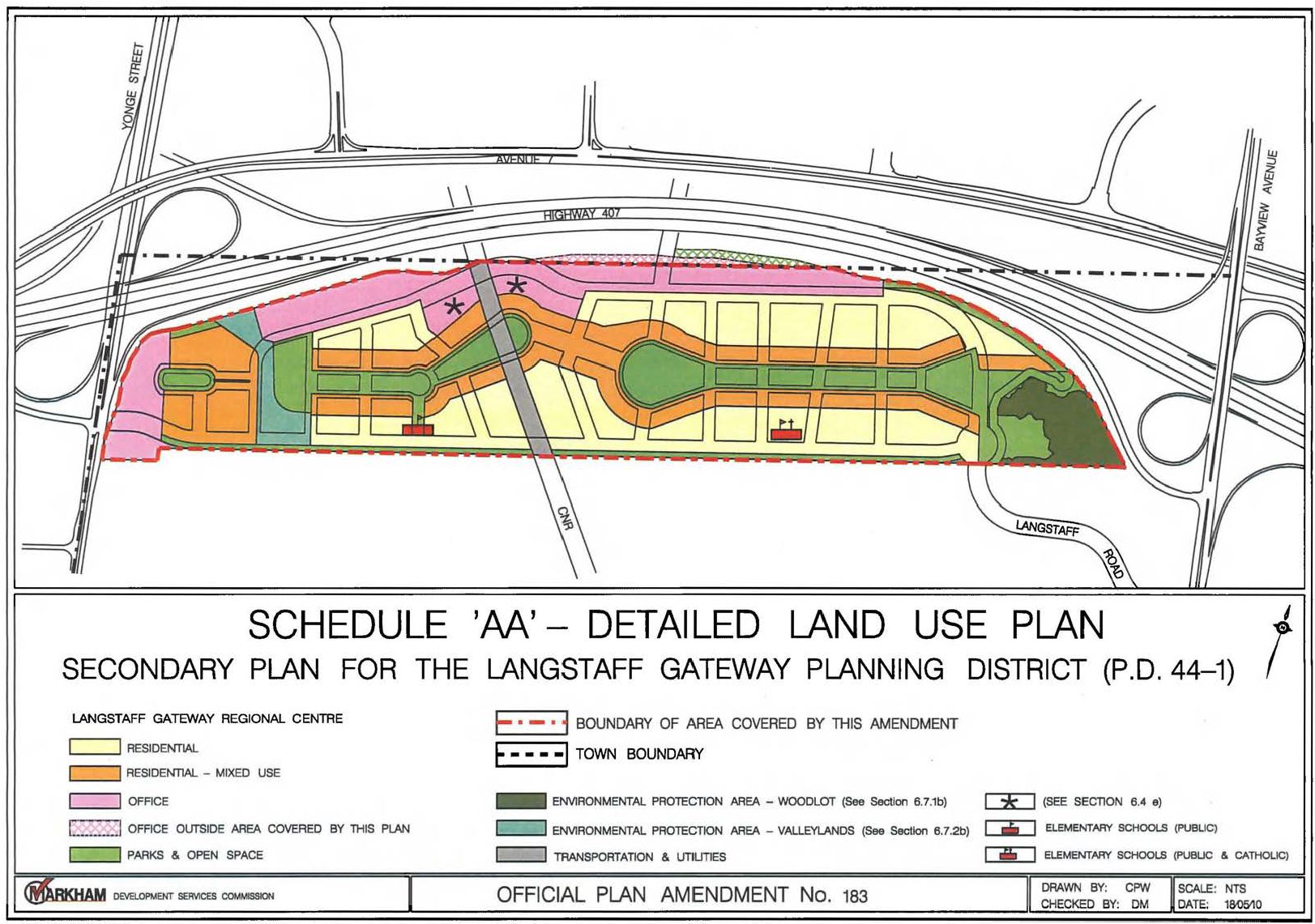
The area south of Highway 407 on either side of the GO corridor is the subject of an Official Plan Amendment 183 of the Town of Markham including a Secondary Plan which foresees a large residential and employment community there. The land is wedged between Holy Cross Cemetery on the south and Highway 407 on the north, and it is divided by the GO corridor which will now also hold the subway extension. Planning for the area began in 2008.
This is a large property about 1.4km wide and 0.3km deep, give or take because of its curving border. Overlaid on Downtown Toronto, it would be roughly equivalent to University-to-Sherbourne, Richmond-to-King. The Town has an aggressive plan for this site. The map from the Secondary Plan shows the intended land use and general layout.
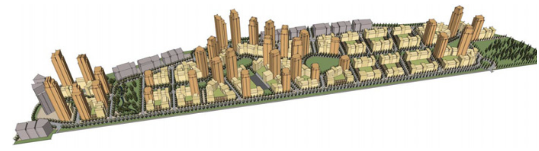
An article on Urban Toronto describes this area and a proposed high-rise development in more detail. The illustration below is taken from that article.
This plan was based on the original subway alignment with a station at Yonge Street and Langstaff Road quite separate from the existing GO station and the proposed Bridge Station on the new subway alignment.
A pair of high-rise towers has already been proposed for the west end of this area, although the location was clearly influenced by what was then expected to be a subway entrance location.
Here is an aerial view of the land from the February 2019 report to Markham Council’s Development Services Committee [report and illustrations].
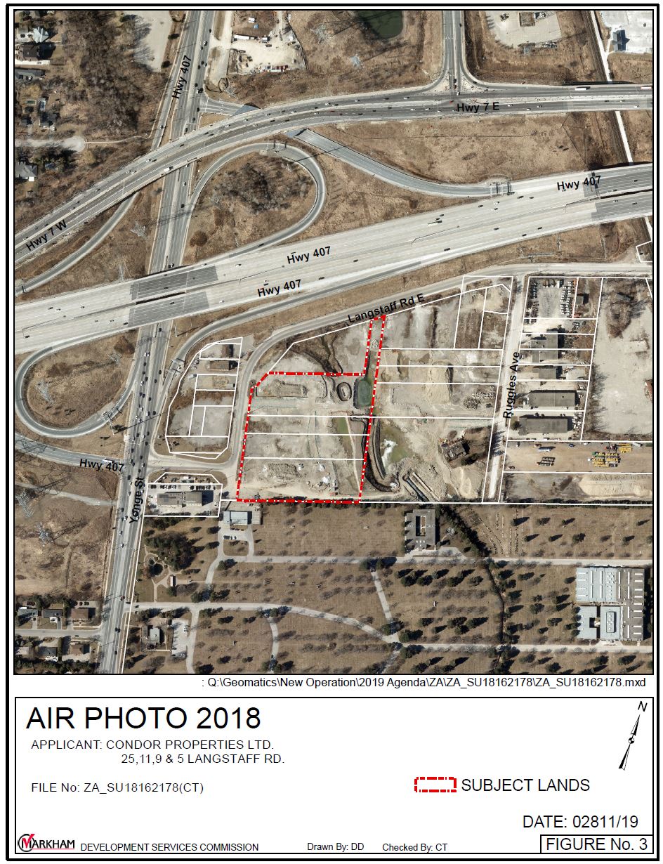
Here is the Precinct Plan for the area between Yonge Street and the GO Rail corridor. Two towers, 37 and 48 storeys, (“A” and “B” in the plan below, the southern pair of four shown at the west end of the site) were proposed to be close by the planned Langstaff Subway Station entrance on the east side of Yonge Street. This entrance does not exist in the updated Metrolinx plan with the subway shifted east into the GO corridor.

Some aspects of the original plan had changed by the time of the West Precinct Plan above. A notable omission is the cluster of buildings around a central square that would have bridged over the rail corridor. This proved to be technically infeasible, and would now be even more complex with two additional subway tracks widening the corridor.
Another notable absence is the “transit spine” which was to run through the development. The layout shown here would allow for a transit route to loop through the precinct, but the status of lands east of the corridor is another matter.
Either an underpass or overpass for any roads crossing the rail corridor pose problems of fitting the approach structures into what was originally a continuous plan for the entire area.
The original plan called for a connector road under the highways as well as a “transit concourse” to provide a protected walkway to the original Richmond Hill Centre Station from Langstaff. The space these would have occupied is now used by the Bridge Station.
A further consideration in this area is whether GO will only ever have a single platform (now east of the east track) or if this will be reconfigured for access to both tracks in anticipation of more frequent service. Vertical access to the combined station and platforms is constrained by the height of the overpasses and the need for vertical clearance for freight trains. Horizontal placement of tracks and platforms is constrained by the columns supporting the highways.
A pedestrian connection through the station will obviously be provided so that the bus terminal can be accessed from south of Highway 407, and this could replace the transit concourse, but the connector road might “fall off of the map” for lack of space.
There are oddities in the land use plan and staging for this area.
Although the intent is for this to be both a residential and employment area, the space for offices is all along the north side up against the highway, probably the least attractive place for residential buildings, and at Yonge Street linking to the now-absent subway station.
Moreover, the staging plan shows that the first phase of the plan would be residential with offices to follow, assuming there is a market for them, at a later date. This means that residents of whatever is built during phase 1 will necessarily work somewhere else, and any commercial activity (e.g. local shopping) will depend solely on residential customers. The area is landlocked by the highways and cemetery, and walkability is not its strong suit, particularly if only part of the plan is actually built.

The plan makes repeated reference to a “transit dependent” community.
From the Official Planning Amendment:
4.3.44.1 General Policies
a) The Langstaff Gateway Planning District is the area generally south of Highway 407, east of Yonge Street, west of Bayview Avenue and north of Holy Cross Cemetery.
The Langstaff Gateway Planning District is planned as a mixed use, intensive urban area incorporating housing, employment and retail facilities, recreational, cultural, institutional and civic buildings to serve as a portion of a designated Urban Growth Centre in the Greater Golden Horseshoe, and a Regional Centre in York Region. The Planning District will be a major activity centre which will be transit dependent as well [as] attractive and comfortable for pedestrians and cyclists and will integrate a high standard of urban design with existing natural features to create a complete community.
4.4.11 Transportation
d) To ensure that the components of the transportation systems required for development of any portion of the Langstaff Gateway are committed to be in place and operative prior to, or coincident with development.
e) To phase the implementation of the transportation system, including transit services, based on acceptable operational and financial criteria in accordance with the Langstaff Gateway Development Phasing Plan to be approved by Council and amended from time to time, in accordance with the provisions thereof.
…
k) To develop a parking strategy and plan to reduce reliance on single occupancy vehicles. The parking strategy should include parking management approaches that include provision of parking structures and on-street parking, maximum numbers of required parking spaces, and support delivery of high density, mixed use, transit dependent development.
8.1.2 Transit
a) In order to provide an attractive alternative to the private automobile and encourage greater use of active transportation and public transit, the form of development in the Langstaff Gateway must be transit dependent and transit facilities and services must be accessible to all potential residents and employees.
“Transit dependent” is hardly how one would design any neighbourhood, especially one well beyond the reach of frequent service and walkable neighbourhoods we are used to seeing in the old City of Toronto.
Although the completed community might have elements that will attract local, short trips, this is unlikely to eliminate the need for auto travel in the wider area. Transit will be provided not as a given but subject to “operational and financial criteria”. This does not bode well for a “transit dependent”.
The parking plan assumes that there will be a reduced need for single occupancy vehicles. How can this be achieved without good, reliable transit and connections to the wider region?
The original aim of the design, as its name implies, was to create a “gateway” that would be announced by towers at Yonge and Langstaff.
5.6 Transit Corridor and Nodes
An internal transit circulation system will be focused at the centre of the Langstaff Gateway community, creating a Transit Spine along the linear park system that links the East and West Transit Nodes portions of the Anchor Mobility Hub with the residential neighbourhoods and the Richmond Hill Centre to the north.
The West Transit Node will be located directly adjacent to the planned Langstaff/Longbridge Subway Station on the east side of Yonge Street. The East Transit Node is located near the existing GO Station, at the entrance to the Transit Concourse, which will connect Langstaff Gateway and Richmond Hill Centre. Clusters of high density residential and employment uses planned for these locations will serve as a visual gateway to Markham and as a regional landmark for this part of the Anchor Mobility Hub. The concentration of densities in the Transit Nodes within walking distance to the subway and the transit mobility hub will support transit ridership.
An important part of transit planning, at least on a theoretical basis, is that local employment is important both to reduce the need for long trips between bedroom communities and employment areas, and to generate bidirectional travel on the transit network. The aims for Langstaff Gateway are set out in the Secondary Plan.
These are noble goals, but there is no guarantee that offices will sprout just because they are in the Precinct Plan. Other would-be “centres” in Toronto have come nowhere near original plans for development, and residential uses have dominated.
6.1.3 General Employment Policies
b) Sufficient lands are designated with the Planning District to accommodate a mix of retail, office and institutional uses generating 15,000 employment opportunities.
c) Employment opportunities in the Langstaff Gateway are intended to contribute to an overall long term Region of York resident-to-employee ratio of 1:1 for the Richmond Hill/Langstaff Gateway Regional Centre. The minimum employment target for this Secondary Plan shall be based on a resident to employee ratio of 1:0.5.
Metrolinx has turned the Langstaff Gateway plan on its head by shifting the subway station east to the GO Corridor. This may well save on construction costs and make more sense with a consolidated regional transit hub, but it completely shifts the focus of the site away from Yonge Street.
Although this is intended to be a large development over many years, there are obvious questions about whether it will all be built, especially the office component, and whether the real attractions for residents lie east-west along the highways, notably further east in Markham. There is a parallel to the Sheppard Subway and surrounding developments which are attractive at least as much because of the nearby highway network the subway.
Is the true purpose of the subway to enable large scale residential development at its outlying stations for a market of downtown commuters? What does this imply for demand patterns to and from the area?
It is ironic that if all of the new residential density translated into peak direction subway riders, this would make the situation on Line 1 even more dire. That would be compounded if the “neighbourhood” stations between Langstaff and Steeles were restored and became development nodes in their own right.

Hello Steve
I have specific questions about noise and vibration impact but would like to have a discussion outside of this forum. I am in the Royal Orchard community and my home is directly impacted by the line three diversion.
Steve: Send email.
BTW Line 3 is the Scarborough RT and so I’m not quite sure what you refer to here.
LikeLike