
This post is a departure from my usual reportage and takes us into the realm of “what would you do” advocacy.
The ongoing debate about Metrolinx’ proposed above ground route for the Ontario Line between East Harbour and Gerrard Stations turns on two issues:
- The effect of a six-track wide shared GO+OL corridor on the neighbourhoods through which it will pass.
- Whether the Ontario Line could be tunnelled.
The debate was recently clouded by a proposed shift in the OL’s alignment. Originally, the line would straddle the GO corridor in order to provide “across the platform” transfers with the outer two GO tracks at East Harbour. Metrolinx is now contemplating shifting both OL tracks to the north/west side of the corridor. This has several advantages as I discussed in a recent article, but it leaves the OL above ground.
The original configuration is shown below in a map from Metrolinx’ site. Note that North is at the right.

Putting the line underground on this alignment is very difficult because of constraints on the grade change between East Harbour and the (misnamed) Leslieville Station. Any descent is constrained by the cross-streets let alone the vertical difference between an East Harbour Station on the rail embankment and a Leslieville Station at Queen.
A neighbourhood group (The Lakeshore East Community Advisory Committee, aka LSE CAC) posed the question to me: is there a way to put the line underground? On the Metrolinx alignment, the simple answer is “no”, but that brings us to the question: why that alignment?
The original Relief Line would have crossed under the Don River on the line of Eastern Avenue with a station at Broadview as shown in the diagram below. The link with GO at East Harbour would not be as simple or direct as in the Metrolinx proposals where the OL and GO tracks and platforms are adjacent.

Metrolinx seeks to offload GO traffic from Union Station and sees transfers to the OL at East Harbour and Exhibition as a solution. However, changes to the planned layout at both stations have stripped the simple across-the-platform transfer for peak directions from their designs.
At Exhibition, only the westbound service would connect with the south side of the terminal station platform. Inbound (eastbound) GO riders would have to access the OL via an underpass. At East Harbour, if the alignment shifts to the north side of the station, the westbound GO track would be adjacent to the eastbound OL track, and there would be no direct link to the eastbound GO platform.
Metrolinx now describes the connections as more convenient rather than direct, but the attraction of a simple transfer to shift traffic has disappeared.
An alternative scheme, which I developed before Metrolinx plan to shift the OL to the west/north side of the rail corridor, uses the proposed eastbound tunnel under the rail corridor as its starting point. Instead of carrying just the eastbound track, it would house both directions, and they would cross the Don River on a dual track bridge south of GO’s trackage where a single eastbound bridge was proposed by Metrolinx.
A shared platform at East Harbour would be oriented to be as far west as possible and only one OL train length (not the full size of a GO platform). The east end of the platform (and hence the point where a descent underground could begin) is dictated by the proposed Broadview extension which would pass under East Harbour Station.
From that point, the line would turn east and descend through what is now largely vacant land and a laneway behind a heritage buildings on Eastern Avenue.
East of Booth Avenue, the line would swing north and join the original Relief Line alignment east of Logan.
The illustration below was prepared by the LSE CAC based on my proposal.

Here is the west end of this area. For reference, the Broadview Extension will cross just west (left) of the water tower (which is to be retained as a landmark in the new development here).
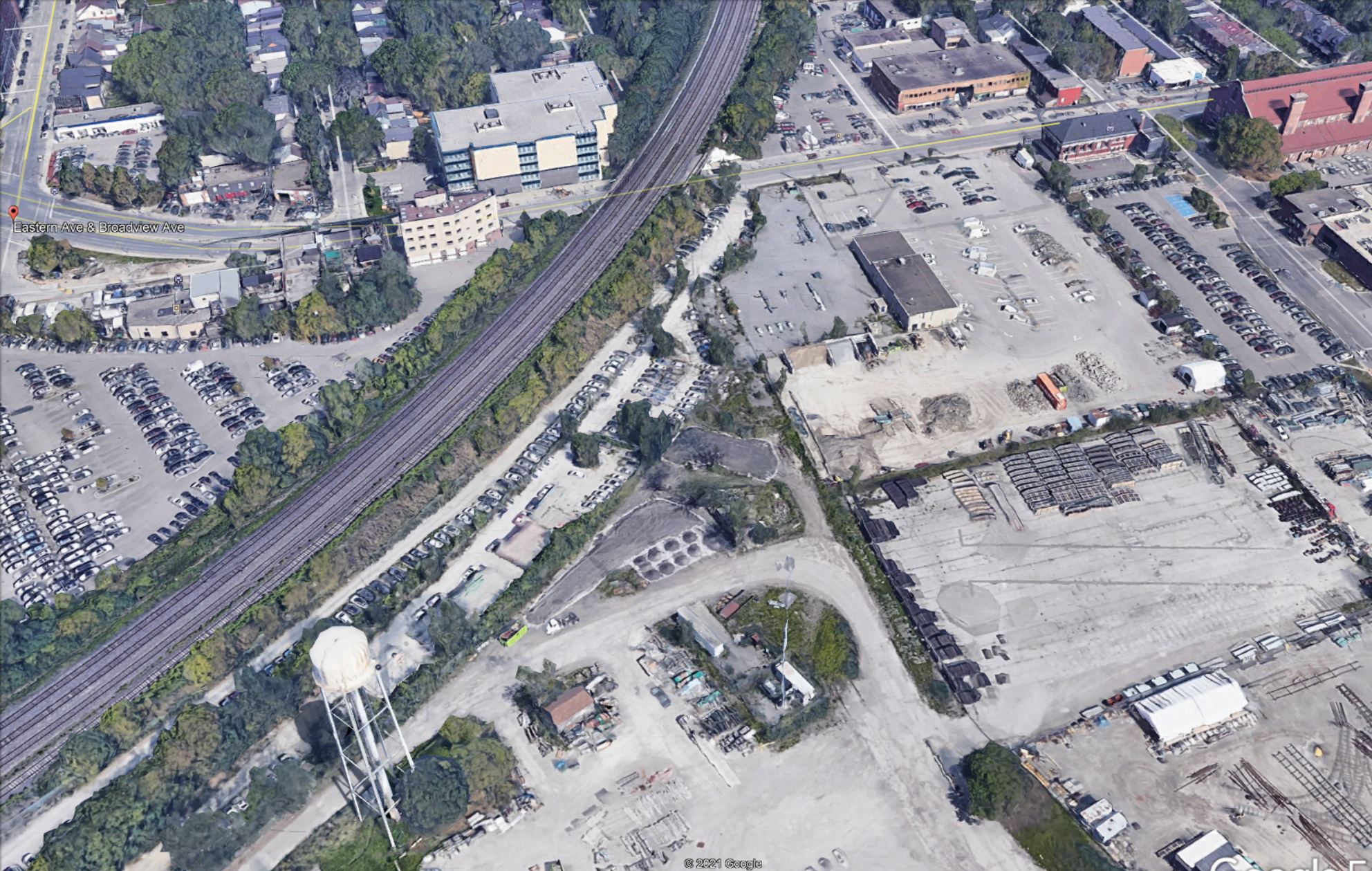
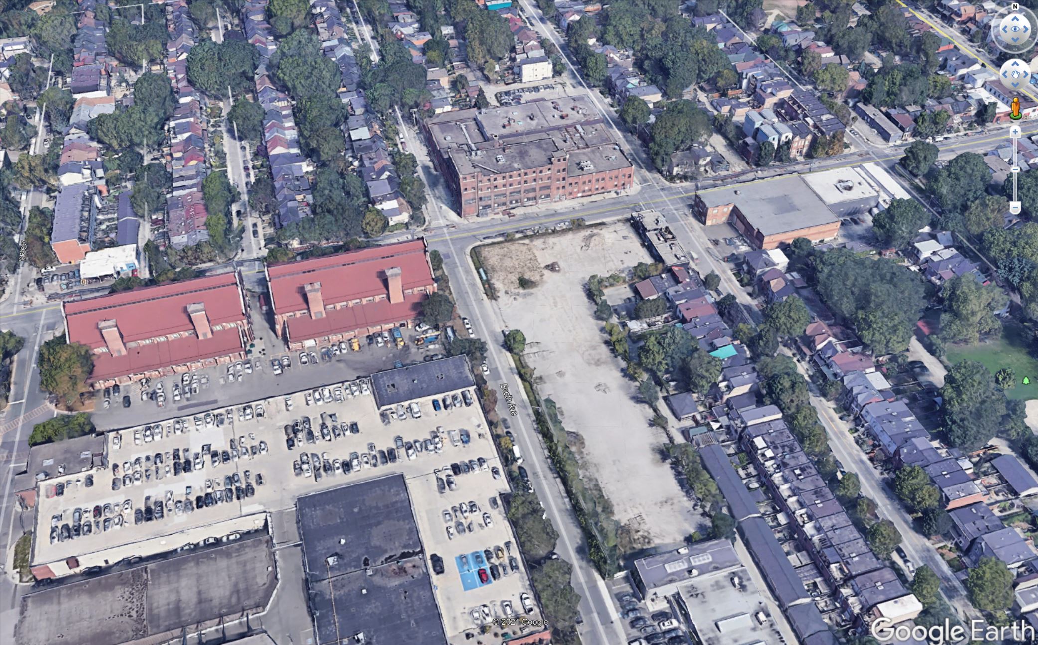
Here is the east end of the area. Note that the vacant lot on the south-east corner at Booth and Eastern in this photo is now occupied by a self-storage building that would have to be removed.
I have no illusions that this would be an easy alignment, but it has advantages over attempting to fit the Metrolinx route under ground:
- The transition from above grade to underground would occur in largely vacant land and before the line must cross a major street (Eastern), preferably west of Booth so that this street would remain open.
- The Leslieville Station is far enough from East Harbour that it does not constrain the vertical alignment in the same manner as the station would at Queen & Degrassi.
Potential issues include:
- The City has plans for this land in the East Harbour development and they would have to be revised to accommodate the ramp and portal structure for the Ontario Line.
- The OL structure would be close to the surface continuing its descent to Carlaw. This could affect utilities where the alignment crosses Booth, Eastern and Logan, as well as some properties along the curve between Eastern and Carlaw.
It is self-evident that an underground route from East Harbour to Gerrard will be more expensive than the Metrolinx proposal along the rail corridor.
Very bluntly, I could be more sympathetic to this issue if Metrolinx were not already pursuing underground options in Scarborough and on Eglinton West at great expense for blatantly political reasons.
This is a proposal for discussion.
