The topics here are a bit scattershot as was the Board debate, but they include:
The Toronto Net Zero 2040 plan and electric buses
The conflict between budget planning timeframes and available funding
The growing backlog in State of Good Repair
Fleet replacement timing issues
Where the money comes from
The need to co-ordinate related projects within the budget
Funding for capital programs
Future subway demand and capacity enhancements
There is always a problem with the complexity of the budget that drops on Board members at most a week before the meeting where it will be approved.
There is no “Budget Committee” at the TTC, and so there is no group within the Board who are primed for the debate and can vouch for management’s work in the same manner as the TTC’s Audit & Risk Management Committee. The Board used to have a Budget Committee, but it languished under an uninterested chair (ironically, a member of Council’s hawkish right) and the current Board is unwilling to recreate it.
This says a lot about how seriously (or not) they take their oversight role. Let a few pencils go missing and the Audit folks will be all over the problem, but billions in capital spending and the underlying policy decisions go with little review. This should be a job for whatever TTC Board is crafted for 2023 after the next municipal election.
As part of the GO Expansion plan, Metrolinx had intended to grade separate the junction at Scarborough Station on the Lakeshore East corridor to eliminate the conflict between frequent service on the Stouffville corridor which runs north, and on the Lakeshore line itself. Plans call for frequent, electrified service on both corridors. All Stouffville and about half of the LSE trains will be electric. Some diesel operations will remain on LSE for trains that will run beyond the end of planned electric territory at Oshawa.
Approval for this project was granted at the end of February 2021.
Four consortia were prequalified for the GO OnCorr project in May 2019, and the RFP process closed on November 30, 2021. The successful bid will be announced sometime in 2022. The consortia include major international rail operators including SNCF (France), MTR (Hong Kong), RATP (Paris) and DB (Germany).
In April 2021, transit video blogger Reece Martin posted an interview with Metrolinx CEO Phil Verster on a variety of topics. Verster talked about a shift in how major contracts are handled including early involvement of proponents in the design phase. The portion of interest includes the following exchange which has been edited only to remove pauses and add punctuation.
PV: Let me give you an example Reece. Just practical examples speak a thousand words for me.
RM: Sure.
PV: We have three big projects overlapping at the new East Harbour Station that we are working with Cadillac-Fairview and the City of Toronto to get built in the Docklands area. And the three projects are: GO expansion, we want more trains on the Lakeshore East; the Ontario Line is going to have platforms at East Harbour; and then we want to build East Harbour itself which is going to be the Union Station of the east. So these are three massive projects that are intersecting.
From the really quality work that we got done by our GO Expansion team, it was evident that if we had a third platform, sort of a centre platform, in the station, we could increase the capacity of trains that can stop at East Harbour by about 8 trains per hour at the peak higher than the 12 trains we had intended. So we can now stop 20 trains an hour rather than just 12, and that 20 years from now when capacity gets constrained at Union Station, we will have saved 2 of the 16 roads. We would have freed up by having this platform in terms of reducing the switchover times between lines which then occupies capacities. So we make in effect 8 trains on 12 increase in capacity at East Harbour, we save 2 platforms out of 16 at Union Station.
But more than that at Scarborough Junction by putting a centre platform at East Harbour, a couple of kilometres down the way at Scarborough Junction, we can now avoid building a rail grade-to-grade separation which saves us $140 million.
RM: That big flyover that you guys had planned before.
PV: Exactly. Now that’s not required because of a station design choice we made further upstream that benefits Union Station as well as East Harbour as well as to the east [?].
You see this is innovation. Now this sounds really boring perhaps for other people that are not sort of rail geeks like people like you and me, but I’m telling you this is unique stuff and it’s super exciting to make these changes. I call these once in 60 year, once in 100 year type decisions that we are making now that will massively benefit this network 50, 60 years from now.
Talking Transit with the CEO of Metrolinx, posted April 15, 2021
It is quite clear that Metrolinx had a revelation about its proposed design for the LSE corridor almost a year ago, and this reflects various design changes that have occurred along the way.
Originally, at East Harbour Station, the Ontario Line would have “straddled” the GO corridor with the eastbound OL track on the south side, and the westbound OL track on the north side. This would have permitted across-the-platform transfers with “local” GO trains running on the outer pair of tracks while the express trains ran through on the inner pair. This arrangement was touted in an October 2019 Metrolinx blog article that remains online.
The straddle option turned out to be problematic not just at East Harbour, but further up the GO corridor at Riverside/Leslieville and Gerrard OL stations which would be much more complex with split platforms, as well as the need for two portals at each end of the surface-running OL segment from west of the Don River to Gerrard Street. Metrolinx abandoned this scheme, and shifted the OL to the north side of the rail corridor. The across-the-platform transfer, previously thought to be essential, was abandoned.
This change allows all train-to-train interchanges to occur at a concourse level under the tracks much as at Union Station. In turn, that also makes possible a platform arrangement with stopping by all GO trains, not just those on two of four tracks.
From a rider’s point of view, it does not matter which track a particular GO service uses, and it is a short step to allocating pairs of tracks to each of two services, rather than to local and express trains. That eliminates the need for the grade separation at Scarborough. (There are implications for Danforth and Scarborough Stations, but that’s a separate matter.)
This is all very interesting stuff, although I would hardly use the term “innovation” to describe moving away from the original straddle design (something else that was an “innovation” in its time) that way. One might ask why it took Metrolinx so long to come up with this scheme and, in the process, simplify operations, increase capacity and reduce project costs.
In a recent Twitter exchange, I asked Metrolinx to confirm or deny that the grade separation had been removed from the project. The GO Expansion team replied:
The reference concept includes minimum service level requirements – how the winning proponent chooses to do that (which grade seps to build, trains, signaling, etc.) is up to them. The contract is designed to spur market innovation in this way.
Metrolinx has completed the necessary TPAPs for all potential grade seps, so needed approvals are in place for financial close, expected in the first half of this year. Once the proponent is on board, we can confirm with certainty which grade separations will go forward. 2/2 ^pp
Tweets by @GOExpansion, January 4, 2022
In other words, the design is up to the winning proponent, even though everything on the Metrolinx website still claims that the grade separation is part of the plan including this October 2020 article in their blog which has not been removed or amended.
Twitter is not an ideal place to get into technical discussions, and it was also obvious that reconfiguration of the platforms and track allocations would have other effects at East Harbour. Therefore, I wrote to Metrolinx seeking clarification of their position.
As presented in all of the consultation materials and discussed in an article on the Metrolinx Blog, there will be a flyunder at Scarborough Junction where the outer eastbound track will connect to the Stouffville corridor via a grade separation to eliminate the conflict with through service on the Lake Shore corridor.
In an interview with Reece Martin on YouTube, Phil Verster talks about a change in the configuration at East Harbour and at Scarborough Junction that eliminates the need for the flyunder and increases capacity at Union Station. Although he does not go into the details, this implies that the allocation of LSE corridor tracks to services will change so that the Stouffville trains will use the northern pair of tracks and the LSE trains will use the southern pair. Coupled with an added platform at East Harbour and through-routing of services at Union, the capacity of the combined corridor is improved by reducing train conflicts and by improving operations at Union.
This is an interesting idea, but when I raised, via Twitter, the question of why it was not reflected in published materials, the response from the GO Expansion team was that decisions on configuration were up to whatever proponent is selected for the GO OnCorr program. That directly contradicts Phil’s enthusiastic statement that this change is happening and the decision has already been taken by Metrolinx.
The only way to reconcile these positions is to say that Metrolinx has not actually “decided” on which configuration to use, but will “suggest” the new scheme as an option for bidders. Alternately, one of the bidders already came up with this idea as part of the work on their proposal evaluation and Metrolinx has embraced it unofficially.
Can you clarify what the situation actually is?
Email from Steve Munro to Metrolinx Media Relations, January 6, 2022
Changes at East Harbour station have ripple effects, and I pursued these questions as well:
There are implications at East Harbour on a few fronts.
First, does the proposed added platform that Phil mentioned alter the alignment of tracks crossing the Don River, and what does this do to the GO and OL bridges and any early works including the Ontario Line alignment?
Second, with the new hook-up of services running through at Union, is there still a need for electrification of the Bala Subdivision (GO Richmond Hill) as a turnback facility, or will you no longer have a service that only runs west from Union and needs that turnback?
Third, one of the rationales used for the Don Valley layover has been the loss of capacity in the existing Don Yard (aka Wilson Yard) due to other projects by which, I assume, you mean the Ontario Line construction. Originally, in the straddle configuration, the OL would have had two portals one on each side of the corridor, but now it has only one on the north side. How does the revised geometry work for the existing yard tracks, the bridges, the OL portal and the connection to the Bala subdivision?
Email, op. cit.
Metrolinx replied:
Hi Steve,
We don’t have any further information to share beyond what the GO Expansion account replied. For further updates, stay tuned to Metrolinx News.
Email from Fannie Sunshine, Advisor, Media & Issues Communications, Metrolinx, January 6, 2022
And there the matter sits. Phil Verster gives a gung-ho interview about innovative design eight months ago, but nothing on the Metrolinx website reflects his comments. A request for detailed feedback nets a “stay tuned” answer.
This whole exchange begs a more delicate question: to what degree can project designs be changed at the behest of the P3 proponent after all of the public reviews are completed based on a proposed design? What other changes might be in the works for any Metrolinx project, and will they just happen without any review or consultation?
To me, the proposed change in track allocation on LSE makes sense, but why is it such a secret?
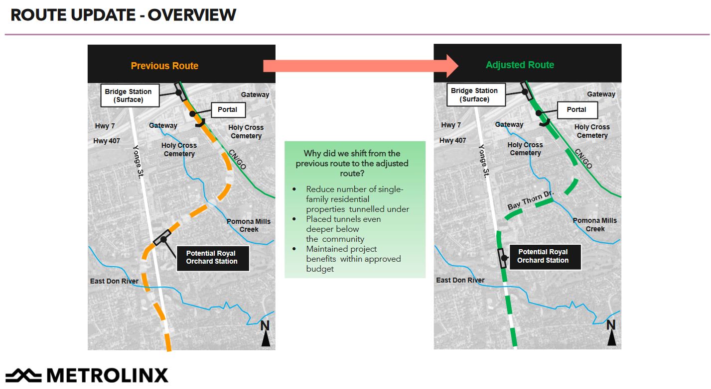
In an uncharacteristically co-operative move, Metrolinx has responded to local complaints about the planned route of the Richmond Hill subway extension under the Royal Orchard neighbourhood.
Originally, the Yonge North line would have run north under Yonge Street including Richmond Hill Station and a storage yard for trains to the north. The revised alignment takes the subway east to the GO corridor before it passes under Highway 407, and the subway runs on the surface north from there with two stations.
The TTC plans a new surface yard north of Richmond Hill, although it is not clear who will pay for this and whether it is still part of the YNSE budget. It is listed as part of TTC Capital and Real Estate plans, and this suggests that part of the extension’s cost (the need for more train storage) remains in the TTC’s lap even though Ontario is funding the subway itself.
The new alignment was announced on the Metrolinx blog on December 8, 2021. I wrote to Metrolinx that day asking for details of the planned vertical and horizontal alignments, and they replied on December 9:
We are preparing to release an update to the environmental assessment for the project in the new year, which will contain more detailed analysis on this specific route. This route will also be the basis for the analysis we complete for the Preliminary Design Business Case, which is also tracking for release later in 2022.
Email from Fannie Sunshine, Metrolinx Advisor, Media & Issues Communications
The information surfaced (so to speak) not long afterward, certainly before an updated EA or Preliminary Design Business Case. Metrolinx obviously thought better of their initial withholding of the route’s details.
On December 15, Metrolinx CEO Phil Verster wrote a letter to the Royal Orchard community going into this change at some length, and even more was provided in an online consultation session on December 16 including its presentation deck.
Horizontal and Vertical Alignments
Here is an overview of the two routes.
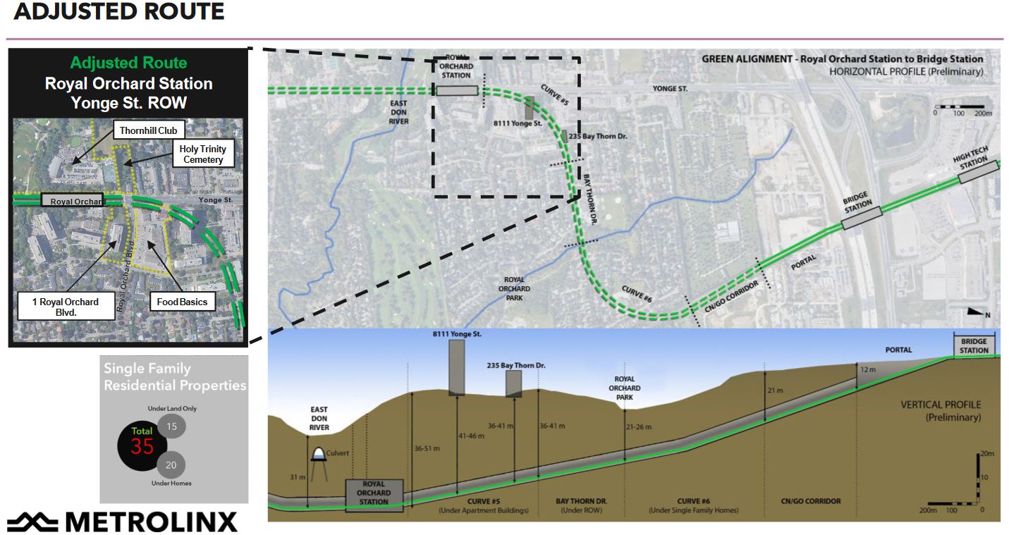
The horizontal alignment has been changed by placing the east-west segment directly under Bay Thorn Drive to minimize the amount of tunnel that is directly under house. This requires that the curves at either end be tightened to make sharper turns from Yonge to Bay Thorn, and then from Bay Thorn into the GO corridor. The Bridge Station planned adjacent to the existing GO Langstaff Station is not affected.
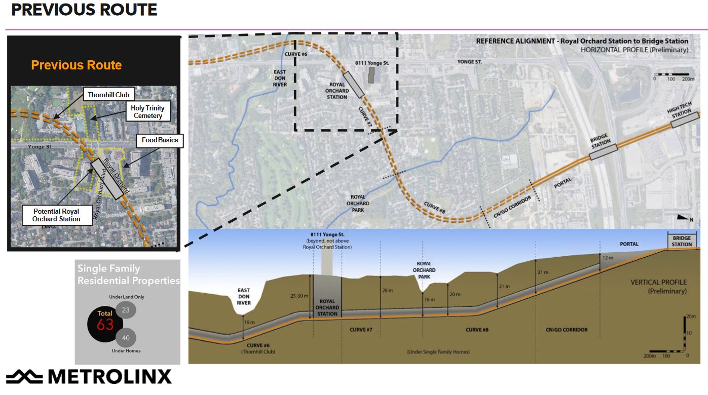
Below are the original horizontal and vertical alignment in more detail. North is to the right.
The subway would initially swing west of Yonge Street and cross under the Don River. It would then travel northeast under the residential neighbourhood with a portal in what is now an industrial area south of Langstaff Road to a surface station under the highway.
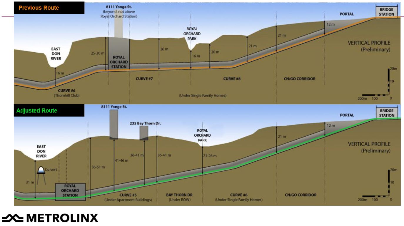
The proposed alternative has both sharper curves and a deeper path. The tunnel under the Don River is almost twice as deep (31m vs 16m), and there is a long climb to just east of Royal Orchard Park where the vertical alignments meet up. The new alignment will require slower operation than originally planned because of the tighter curve radii.
If a Royal Orchard Station were ever added to the plan it would be considerably deeper in the new alignment than the old at a depth comparable to some of the proposed downtown stations on the Ontario Line.
The vertical alignments are compared in the drawing below.
Two alignments proposed by Transport Action Ontario were rejected because of various issues such as the effect on planned developments, the complexity of the portal and Bridge Station, and the extra cost of these schemes. Metrolinx states that its revised proposal keeps the project within its budget.
The TTC’s 2022 Capital Budget report has been published as part of the December 20, 2021 TTC Board meeting agenda. This includes three components:
A 15-year capital investment plan giving an outlook on all projects, funded or otherwise, to 2036.
A 10-year capital budget for funded projects.
A real estate investment plan that ties property needs into capital planning. This is a new component in TTC capital planning.
For political reasons, the capital plans before 2019 were low-balled to stay within available funding, but this hid necessary projects that appeared as a surprise to the TTC Board and Council. One way this was done was to class them as “below the line” (not in the funded list), but more commonly to push their supposed delivery dates beyond the 10-year capital budget window. This made the City’s exposure to future spending appear lower than it was in fact.
A particularly bad case was the collection of projects and contracts for ATC implementation on Line 1. In order to “sell” this badly needed project politically, it was subdivided and some resulting contracts used mutually incompatible technology. The original chunk was simply a plan to replace the existing block signals used from Eglinton to Union and dating from the subway’s opening in 1954. One by one, other pieces were added, but the disorganization was such that ATC was actually an “add-on” to the Spadina extension because it had not been included in the base project.
The situation was further complicated by awards to multiple vendors with incompatible technologies on the premise that each piece could be tendered separately without regard for what was already underway. A major project reorganization during Andy Byford’s tenure as CEO untangled this situation, and provided a “lesson learned” for the Line 2 ATC project.
In 2019, the TTC changed tack and published a full list of its needs and extended the outlook five more years. This came as a huge shock to politicians and city management when the capital needs shot up from $9 billion to well over $30 billion.
On December 7, Toronto’s Executive Committee considered the long staff report on Ontario Line downtown construction effects on which I have previously reported. That report was supplemented by a staff presentation.
To watch the full presentation and debate click here [YouTube link].
Although the Building Transit Faster Act gives Metrolinx the power to do whatever it wants in advancing this project, the City hopes that they will be a co-operative partner. Much of the debate turned on the effects of the long-term shutdowns, and to that end a long series of amendments was passed. Collectively, these seek to create a monitoring and reporting structure for the project and to ensure that the scope and duration of its effects are kept to a minimum.
This will be a challenging environment because unlike a TTC project, the primary relationship is between Metrolinx and their P3 partner, generically called “ProjectCo” pending a selection of a successful bidder, and the City/TTC have no power nor contractual relationship to enforce their will on the project.
Media coverage and political reaction has focused on the planned seven year closures at many sites. The staff presentation and comments repeated that the planned closures are the maximum that will be permitted, although what the City might do if the hole in the street has not been filled is anyone’s guess. The procurement includes an incentive to reduce the duration of closures, but it will be some time before we know whether “ProjectCo” will agree to a faster project at some or all of the stations.
At its meeting of December 8, 2021, the TTC Board received a report and presentation about the Bloor-Yonge project. This is a massive undertaking to expand capacity at the major junction of the subway network that is considered critical to future demand growth on the network.
Funding to the tune of $1.5 billion is already committed by the City, the Province of Ontario and the Federal government.
The project will:
Add a new, separate eastbound platform on the south side of the existing station similar to the reconfigured Union Station where a northbound-to-Yonge platform was added.
Convert the existing centre platform to westbound only.
Add and reconfigure vertical access between the concourse east and west of the Line 1 station to Line 2 below.
Substantially increase the concourse space.
Increase ventillation fan capacity to reflect both the expanded station area and current fire code.
Add new entrance connections at 81 Bloor East and link the existing automatic entrance on Yonge north of Bloor to the new platform.
Reconfigure the main entrance of the station at 2 Bloor East.
In pre-pandemic times, severe congestion was common particularly, but not only, on the southbound platform. If nothing is done about this, the safety issues this brings will become more severe and train operations will be hampered by the volume of passengers.
Although Automatic Train Control will allow for more frequent service, this also means that passengers can be delivered to the station at a faster rate than today. If stairs, escalators and platforms cannot handle the added demand, the station will be a pinch point on the network. At a political level, the City of Toronto Council is already on record as requiring this expansion (as well as the Relief, now Ontario Line) as pre-requisites for the Line 1 Yonge extension to Richmond Hill.
The issues facing the TTC are summarized early in the presentation deck.
Modification & expansion of the existing Bloor-Yonge Station required to address current issues and future ridership demand as follows:
• Overcrowding of the Line 2 platform due to substandard platform width and congested vertical circulation in the AM and PM peak hour
• Overcrowding of the Line 1 platforms due to poor passenger distribution leading to congestion and queuing at vertical circulation in the AM and PM peak hour
• Overcrowding of Lines 1 and 2 platforms AM and PM peak hour hampering alighting and boarding leading to increase in dwell time for trains
• Projected ridership growth will exacerbate current deficiencies in station performance
• Projected ridership growth will greatly extend recovery time from a missed headway
This is the fifth and final article in a series reviewing the construction effects of the Ontario Line downtown. It deals with overall issues across the project rather than the specific issues at each station.
In reading the report, there is a sense that working out traffic flows for motorists and trucks took a much higher priority than thinking about transit, pedestrians and cyclists.
The Ontario Line stations are projects on a scale and time frame larger than major building construction projects, and the work will be undertaken by an agency that is not noted for its sensitivity to local concerns. If Eglinton was any indication, there will be plenty of opportunity for finger-pointing between Metrolinx, the City and “Project Co.” (the placeholder name for the yet-to-be-selected P3 partner).
City Led Projects
In addition to the work of building the Ontario Line, there are other planned construction projects downtown. The list below only reaches to 2026.
The following City-led construction projects were included:
Gardiner Express Rehabilitation – Grand Magazine Street to York Street (2024 to 2026)
TTC 504 King streetcar track rehabilitation – 2024
Yonge Tomorrow – Reconfiguration of Yonge Street between Queen Street and College Street
Sewer Rehabilitation –
Richmond Street between Simcoe Street and John Street (2023);
Richmond Street between Peter Street to Spadina Avenue (2023);
Wellington Street between Clarence Square and Blue Jays Way (2024);
Front Street between Bay Street and Scott Street (2024).
Watermain Replacement –
Adelaide Street between York Street and Victoria Street (2022);
Dundas Street, between Church Street and Sherbourne Street (2024);
Front Street between Bathurst Street and Spadina Avenue (2026).
Congestion
The table below shows the effect of various configurations on traffic volumes and speed for the AM and PM peak periods.
The Base Case is the existing conditions with no added projects.
The “Future Background” adds in the City projects listed above, and assumes that they all happen at once. In fact they will take place at different times.
The “Future Total” adds in the effect of the Ontario Line construction on top of the City projects.
The base number is the projected vehicle count on each corridor at Yonge Street. The number in square brackets shows the existing travel time (Base Case) and the projected change (Future Cases) between Parliament and Bathurst Street.
King is notable by its absence in the table, but it is hard to believe it will not be affected especially with the lack of enforcement of priority measures. It will be under construction in 2024, but in other years traffic will inevitably use any available street regardless of signage or paint on the roadway.
Travel times are already considerably higher in the PM peak than in the AM. The projected changes in the AM peak are small relative to the base case because the road network can absorb the reduced capacity at that time. However, in the PM peak, travel times double (or more) across the core area.
This will have a severe effect on transit service.
Considering the cataclysmic effects shown above, this table bears close scrutiny. An immediately obvious point is that almost all of the change is the result of the City-led projects and the Ontario Line construction adds very little on top of this. But the model assumed that all of the City projects planned out to 2026 would occur at the same time rather than individually.
This is lazy modelling, and it should be redone on a year-by-year basis to evaluate the effect of taking specific chunks out of the road network as planned.
Equally important should be a model run with only the Ontario Line changes included. It is possible that the model with only all of the City projects yields so much congestion that there is no room for “growth” on that account when the OL is added to the mix.
A rather obvious question here is how construction vehicles are supposed to access the OL sites if traffic is so congested during part of the day. Indeed, one might ask whether a moratorium on truck activity during at least the PM peak will be needed.
A well-known characteristic of traffic congestion is that it can build slowly with volume, but at a critical point there is a “knee in the curve” where congestion gets much worse with only a small change in the network. This is seen on a day-to-day basis when all that is needed to snarl an otherwise open road is a curb lane blocked by a delivery truck or utility workers with a few traffic cones.
This is the fourth article in a series about the anticipated effects of construction through downtown of the Ontario Line. Because the stations at Moss Park and Corktown are similar in their construction technique, I have grouped them together.
Both stations will be built as off-street using cut-and-cover rather than mining because the entire station site can be opened for access. Effects on pedestrians are less severe, and transit stops are undisturbed.
However, the scope of work is much greater at Corktown Station because this will be a Tunnel Boring Machine launch site. Not only will this see the excavation of the station itself, but the removal of “muck” from the TBMs as they progress west across the route.
This is the third article in a series about the anticipated effects of construction through downtown of the Ontario Line. Because the stations at King/Bathurst and Queen/Spadina are similar in their construction technique, I have grouped them together.
Two of the four corners at each intersection will be used for excavations down to the tunnels which will exist by the time station construction begins. The plan is to avoid road closures that would disrupt transit service, not to mention capacity on the road network.
This may sound good in theory, but transit service will suffer from new pinch points in the road network, and pedestrians will attempt to make connections between transit routes walking along roadways adjacent to construction zones. Although there are no formal cycling lanes on streets at either station, a substantial volume of cycling traffic now uses curb lane space that will disappear.
In both cases, construction is planned to run from July 2022 until mid-to-late 2029.
July 2022 to June 2023: Setup, utility relocation and enabling works
July 2023 to March 2026: Excavation
March 2026 to September 2027: Below grade concrete work
Fall 2026 to Fall 2027: Exterior station work
June 2027 to September 2028: Interior station work
March 2028 to March 2029: Station fit out and testing
There is no plan to selectively re-open parts of the street once the major works of excavation and concrete pours are out of the way.
An obvious issue for the long term is that no sooner will subway construction decamp from these sites, but new building construction will move in. The loss of sidewalks and road space could continue well into the 2030s.
When I asked the City of Toronto about this, they understandably have no information on the time frame or effects of potential developments of these “Transit Oriented Community” sites to be developed by Infrastructure Ontario.
[…] although these sites have been flagged as TOC’s we don’t currently have any details around these and their construction impacts. If lane closures are required for their construction then reports will need to come forward to City Council at the appropriate time which will spell out the occupations required and impacts.
Ashley Curtis, Director Transportation Planning & Capital Program. Dec. 2, 2021.
This continues the series reviewing the construction plans for downtown stations on the Ontario Line and their effect on roads and nearby properties.
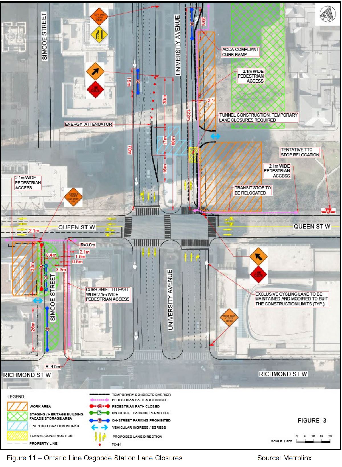
Like Queen/Yonge station described in the previous article, Osgoode connects with the Line 1 subway in a new two-level station. However, the construction approach will be completely different.
The expanded Osgoode Station will be dug from two excavations at opposite corners of the station rather than from access pits in the middle of Queen Street. The primary entrance to the expanded station will be at the northeast corner of University and Queen, a space now occupied by part of the park in front of Osgoode Hall.
A second entrance to the station will be built at Queen and Simcoe and will use the existing bank facade for its exterior.
The diagram below shows a much larger portion of this park to be occupied for construction than was previously thought to be threatened. Compare the orange hatched area below with the next drawing from the June 2021 round of consultations.
This drawing shows “Station Building 1” occupying about half of the frontage on University between Queen Street and the gate to the walkway across the front of Osgoode Hall. In the diagram above, the entire width of this area is taken for construction as well as part of the area north of the walkway along the street, and the lawn in front of the Hall.
Given the effect any work within the Hall’s grounds will have on the park, this is not a trivial change. Quite bluntly, I believe Metrolinx showed the smaller scope in the drawing above because proposing to take so much of the park, even temporarily, would have produced an uproar. They stick handled their way around any discussion of Osgoode Station during the consultation sessions. This has the smell of deliberate misrepresentation.
If anyone is considering a design based on a proposed reallocation of lane space on University and expansion of the east side pedestrian realm, they have been very quiet about it. Conveniently for Metrolinx, this is not a residential neighbourhood with the usual population of critics quick to leap on their proposals.
All of the trees at Osgoode Hall in the photo below lie on lands shown as the construction zone for this project. Civic vandalism in the name of “progress” does not begin to describe this proposal.
University Avenue Looking North at Queen, June 2021 / Google Street View
Early Works
The main construction work begins in July 2023 with station excavation running to March 2026. The station exterior would not be complete until Fall 2027, and the lane closures would not be undone until sometime in 2029. (See the city’s report for details.)
However, some works must take place in advance of the main project:
Utility relocation from March 2022 to May 2023.
Other “setup, preparatory and enabling works” from July 2022 onward. It is not clear just what these entail or which areas of the site would be affected.
At various times in 2022 there will be short-term closures of parts of Simcoe Street and University Avenue (see the list of Early Works closures for details).
Street Restrictions
For much of the project, various lanes and parts of sidewalks will be close or restricted:
Queen Street road lanes will not be affected.
On the east side of University to north from Queen (see photo above), the street is now four lanes wide with the curb lane used for a bike path. In this area, the sidewalk will be taken over for construction and pedestrians will be shifted into what is now the northbound curb lane.
NOTE: The report is unclear about whether there will actually be a cycling lane or not, or when. “The existing northbound curbside bicycle lane on University Avenue fronting the Osgoode Hall will be closed for construction staging purposes. However, the northbound travel lanes on University Avenue will be realigned and a protected 2.0 metres wide northbound bicycle lane around the work zone will be provided.” [p 28]
On Simcoe Street, the west sidewalk and part of the street will be closed between Queen and the laneway running midblock west from Simcoe. The intent is to use the west side of Simcoe as a staging and storage area.
The east sidewalk on Simcoe will be narrowed to leave enough room for one traffic lane and a cycling lane, although that lane is not shown clearly on the drawing above.
Pedestrian access will be maintained in front of the bank/second entrance building along Queen west of Simcoe.
Here is what Simcoe Street looks like today. The bank on the left will become the second station entrance.
Simcoe Street Looking North to Queen Street June 2021 / Google Street View
Transit Changes
The only explicit changes proposed for this area are the relocation of the westbound streetcar stop east to a point clear of construction, and closing the existing station entrance north of Queen on the east side of University.
The report proposes a westbound York/University stop on Queen, but this would be closely after streetcars have stopped northbound on York at Queen. With the northeast station entrance closed, passengers transfer passengers are more likely to use the southeast entrance (through the Opera House) and a stop on the north side of Queen does not make sense. Better that transfers walk between the Opera House entrance and the proposed stop at York & Queen along the south side of the street.
The eastbound stop on Queen at University will remain.
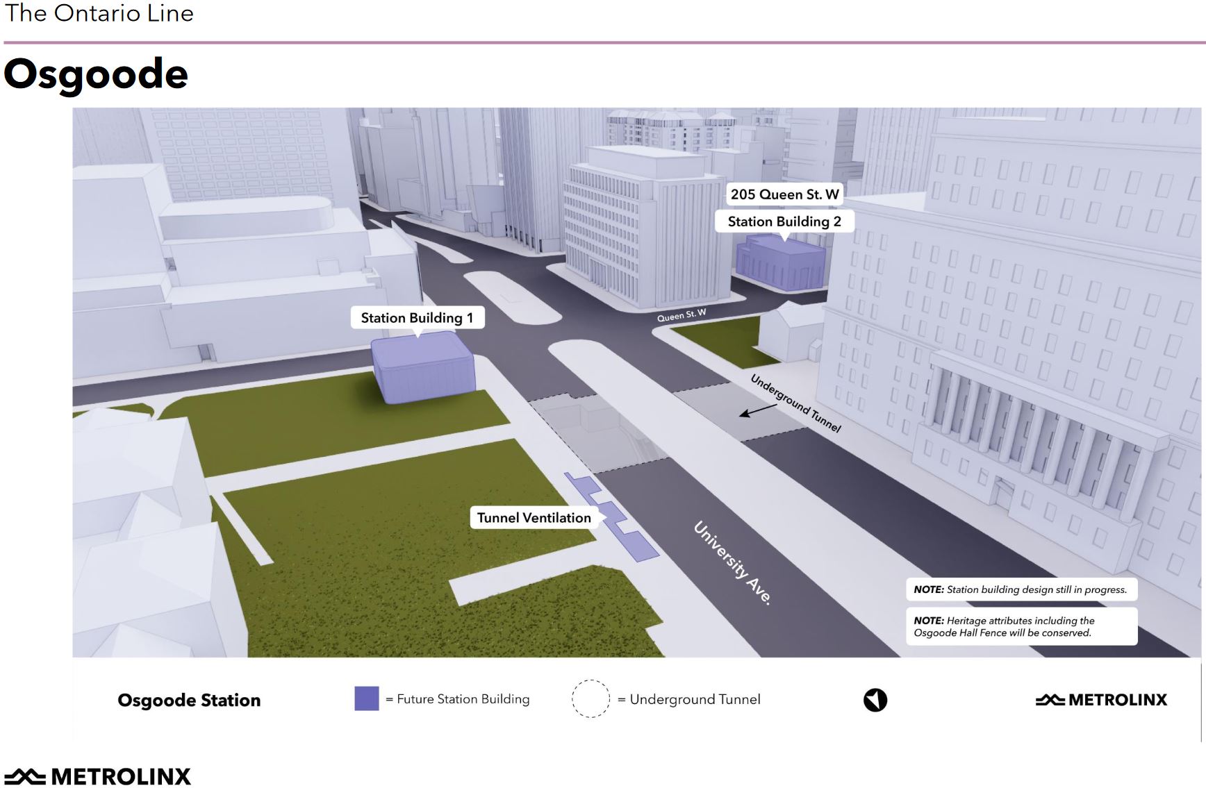
Metrolinx has not published diagrams of Osgoode station below street level showing how the existing and new spaces and circulation patterns will work.
In the next article, I will review King/Bathurst and Queen/Spadina stations.