
This is the first of a series of articles reviewing the plans for construction of the downtown Ontario Line stations between King/Bathurst and Corktown Station. The base document is a report at the Toronto Executive Committee’s meeting of December 7, 2021.
- Ontario Line Downtown Stations – Temporary Road Closures and Community Impacts
- Appendix A – Ontario Line Early Works Construction – Road and Lane Closures for Six Downtown Stations
- Appendix B – Traffic By-law Amendments
- Appendix C – Key Intersection Measures of Effectiveness
This is a long report detailing the effect of multi-year construction at six sites. Beginning with early works in 2022 and continuing to 2029, each of the sites will be at some stage in construction, although the exact timetable varies from station to station.
The project will involve many curb lane closures and associated effects on sidewalks, bike lanes and transit stops. As previously reported, there will be a complete road closure of Queen from Bay to Victoria for the construction of a deep and complex link there to the existing Line 1 Queen Station. Osgoode Station is a less complex project because there are fewer nearby buildings constraining the site, although it has its own challenges.
King/Bathurst and Queen/Spadina are similar to each other in that they will use shafts on two of the four corners of their intersections as the launch points for mining out the station caverns under the street.
Moss Park and Corktown Stations are both cut-and-cover locations, but Corktown has the added complexity of also being a site for the tunnel boring machine launch and for removal of spoil from the tunnel excavation.
Each site has other issues:
- Volume of spoil from the excavations and the routes trucks will use to move material from six concurrent construction sites.
- The constraints on emergency vehicles while road access is limited.
- Local business and residential access.
- Cycling lane effects.
In all of this, we must assume that traffic, transit, pedestrian and cycling demand will be at least at pre-covid levels, although there are likely to be shifts as some traffic “evaporates” in frustration.
This first article will deal with the most complex project: Queen Station. Next will come Osgoode, to be followed by the two western stations at Bathurst and Spadina, and then the eastern stations at Moss Park and Corktown. I will wrap up with a discussion of issues common to all sites.
Queen Station in Cross Section
In a previous article, I reported on Metrolinx consultations for the downtown section. This included a Metrolinx drawing of the new Queen Station seen in cross-section looking north.
Two excavations are required east and west of Yonge to provide future vertical access down to the Ontario Line. These will be used during construction as staging areas for mining the station platform area. The white box in the centre of this drawing is bedrock that will be left as is.
At the surface, there is a new east-west concourse that will expand the existing underpass at Queen Station. This will be dug out as cut-and-cover construction initially with the digging open to the air, and later with the work site decked over.

West Side of Queen Station Site
The drawing below shows how streets will be affected from Bay to Yonge during the main part of construction.
- Queen Street will be closed at the east side of Bay Street. Pedestrian access will be maintained on both the north and south sides of the street, but the “cattle crossing” west of Yonge will be closed as this will be an active construction site. The bridge across Queen Street will remain open.
- The area shaded in orange east of James Street is the west excavation shaft down to the new station.
- James Street will be closed south of Albert Street. Pedestrian access will be maintained except for a segment of the east sidewalk north of Queen
- Albert Street will become a two-way, and parking will be prohibited on the north side. Turns into Albert from Bay will be permitted in both directions. Note that Albert Street is the north exit from Queen Station via the Eaton Centre and there is a direct path through the mall to Yonge Street.
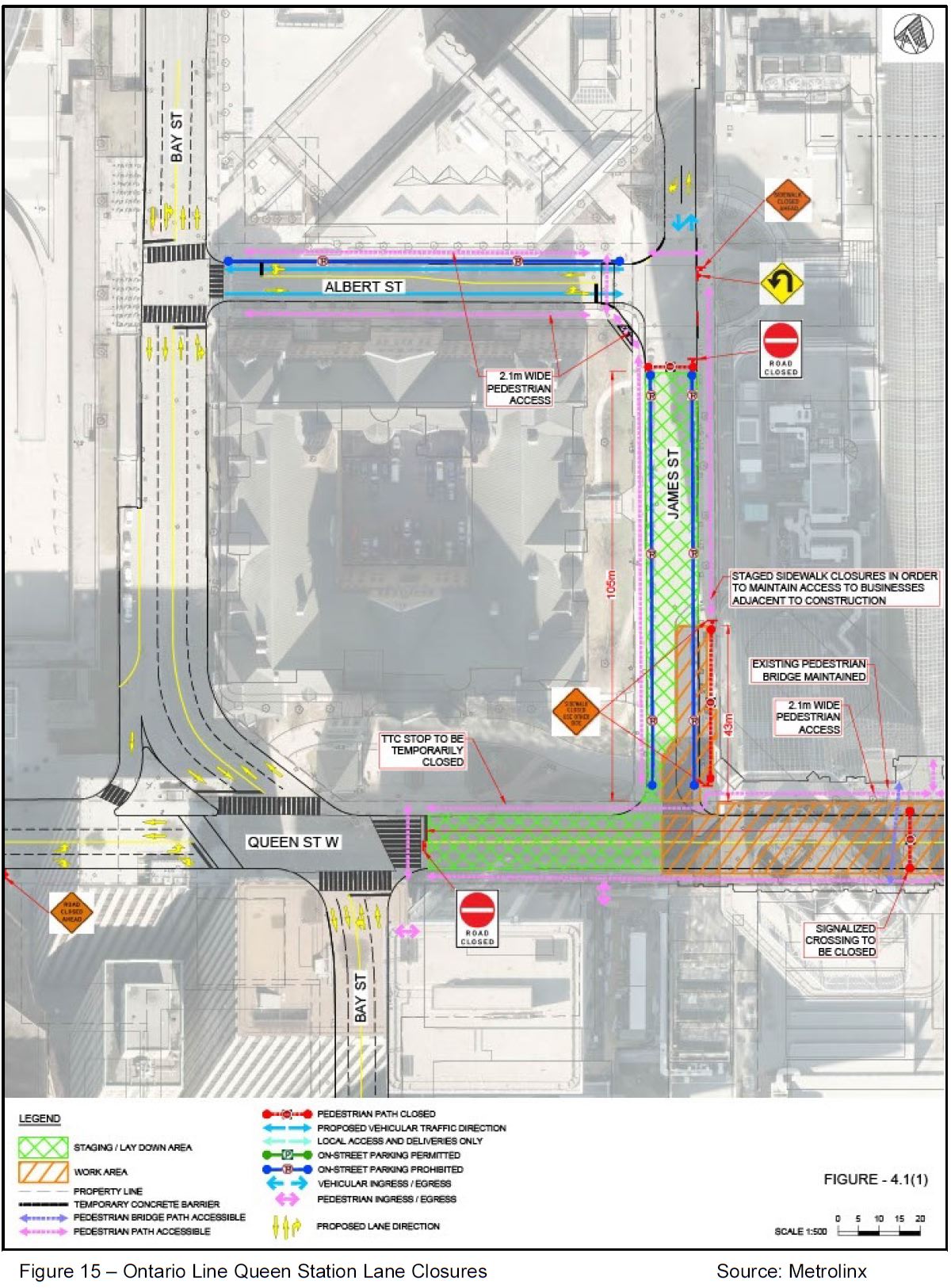
East Side of Queen Station Site
The streets east to Victoria will be affected by construction.
- Queen Street will be closed through to the west side of Victoria Street, although pedestrian access will be maintained on the north side. On the south side, the sidewalk will be closed for six months in the middle of the block from Yonge to Victoria. The plaza on the southwest corner at Victoria will be used as a pedestrian diversion around construction.
- The southbound curb lane of Victoria will be used as a construction staging area (green in the diagram below).
- It is not clear to what degree the streetcar trackage on Victoria Street will remain operational. North of Queen it has been out of service for a long time during construction at St. Michael’s Hospital and Massey Hall. South of Queen, it is part of a common short turn loop.

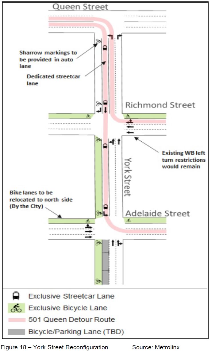
Streetcar service will divert, as previously announced, between Church and York Street including the addition of a new southbound track on York from Queen to Adelaide. There will be no service at the existing Queen Street stops.
The map below shows the stop westbound at University as “retained”, but in fact it will be relocated to the east as part of the work at Osgoode Station.

The configuration of York Street will be:
- West curb lane:
- A shared auto and cycling lane southbound to Richmond (this segment is already used between Queen and Richmond for access to the Opera House loading dock).
- A cycling lane from Richmond to King connecting with the Adelaide Street lanes that will be shifted to the north curb lane.
- A transit-only lane for streetcars southbound. Between Adelaide and King, this lane’s function is to be determined.
- Northbound lanes will continue to operate as they do today. Note that northbound trackage already exists on York between Wellington and Queen Streets.
Adelaide Street Reconstruction
The City plans to rebuild Adelaide Street which is in very poor shape after a few decades of office and condo construction and many pavement cuts. The streetcar track has not been operational for many years, but it will be restored east of York for the 501 Queen streetcar diversion. The City and TTC also plan to restore the track between Charlotte and York Streets for diversions around events both on King and Queen.
The City will be responsible for:
• Delivering the Adelaide Reconstruction project and identifying opportunities for accelerating components from York Street to Church Street to connect with the planned streetcar track on York Street and Adelaide Street between Charlotte Street and Victoria Street, in a timely manner such that the detour is operational for the scheduled closure of Queen Street, including, a review of schedule mitigation options for delivery of the streetcar tracks; and
Impacts Report P 40 (italics added)
This work will occur early in the project:
[O]n Adelaide, the Adelaide Reconstruction project will take place in 2022, with the critical work zone (York Street to Victoria Street) completed before March 2023, allowing the streetcar detour to be in place during the Ontario Line construction.
Ashley Curtis, Director Transportation Planning & Capital Program, email of December 2, 2021
Early Works
The main P3 Metrolinx contract for the stations will be awarded separately from early works that are needed to prepare the site for construction. These include relocation of many public and private utilities as well as the diversion trackage noted above.
Queen Street will be closed from June to August 2022 for utility work, but the York/Adelaide detour track will not be available at that time. There will be a bus shuttle of some kind. The westbound detour via Richmond would be possible because this track already exists. The exact configuration of service during this period remains to be seen. A second closure prior to the York/Adelaide link being available might occur in 2023 according to the report, although the City (see above) seems intent that this will be available before March 2023.
James and Albert Streets will also see temporary closures/reconfigurations during the Early Work period.
In addition to rehabilitation of the Adelaide Street trackage, there will be watermain replacement, road resurfacing and bikeway reconstruction (including the shift to the north side of the street).
Station Box
The station will be tunneled through bedrock about 45m below ground from the two excavations at either end of the future station. This work is scheduled to begin in May 2023 with the street remaining closed until mid 2027. After surface restoration, station fit out, testing and commissioning would continue underground.
A detailed schedule breakdown is in the Impacts report.
The report discusses a partial closedown option, but it was rejected because the project would be more complex and expensive, and would take a year longer.
Other Matters
Other issues include:
- Changes to cycling routes and facilities
- Haulage of spoil from excavations
- Emergency vehicle operations
- Traffic impacts and transit priority
These are better seen in the context of the road network affected by all of the stations, and I will turn to them in a separate article.

That’s a little less than what’s detailed behind the “closed for seven years” headlines months back.
Here’s from the CBC:
Perhaps designers and contractors have had time to realize newer building methods pioneered in the East and Europe make for much faster construction sinking pre-cast panels into trenches to build the ‘box’, and then excavating the volume contained after beneath a restored streetscape above.
Many excellent engineering descriptions on-line, these are some of many:
New Civil Engineer:
Hopefully Metrolinx will have learned from the folly of Crosstown methods.
Steve: Note that construction techniques in clay are not the same as in rock. You cannot transplant designs between stations without considering the local conditions.
LikeLike
Do you know if the TTC will operate this line?
Steve: At this point, I would say not. The trains will be fully automated, and operations are included in the P3 for “RSSOM”: Rolling Stock, Systems, Operations and Maintenance.
LikeLike
Ganz verrücht! For how many years will all this go on? What transit traffic will be there when they finish multiple years of blockage. (And I still suspect that pre-covid loading will not return in my son’s lifetime!) Andy Biemiller
LikeLike
I should have added thanks to Steve for providing these detail! Andy
LikeLike
Hi Steve,
Slightly off topic, I was shocked to see the depth (~45m) of the Ontario Line platform in your original (and again here). For reference, how deep is the south exit (Old York Mills Rd) at York Mills Station? This does not look like a sensible transfer point (perhaps they should install multiple cargo elevators in addition to the 12 flights of stairs and the admittedly more reasonable (and presumably higher trafficked) 4 escalators. . .
Steve: York Mills is not as deep as the OL Queen Station even at the south end of the platform. On his Station Fixation site, Nathan Ng refers to the escalator to the Old York Mills exit as “76 steps to freedom”. An escalator riser is less than one foot, but even if it were, 76 feet is only 23 metres.
Considering how much of a fuss Metrolinx made about the across-the-platform transfer at East Harbour and Exhibition, and the rather condescending remarks they made about the depth of the Broadview/Eastern station design on the Relief Line, they seem unconcerned with the fact they are making stations with very long access times to the platforms, except where it suits them.
LikeLike
They seem very confident they don’t need to close Queen St for Osgoode station construction. I might have been tempted to extend the Adelaide/Richmond detour west past York to Duncan, John, or Peter to avoid the Osgoode station mess.
Steve: Osgoode will be built in a completely different way from Queen/Yonge. It will be mined out from access shafts at the ends of the station north and south of Queen Street.
LikeLike
I’m worried that the detours for the streetcars and buses would have to share with the single-occupant automobiles. It would be better if the detours be provided with transit right-of-ways separate from the automobiles.
Convert the NO PARKING to NO STOPPING around the construction and actually ENFORCE them, so the automobiles still have a route for them. However, I can see the automobile addicted powers-that-be being against this suggestion.
LikeLike
Looking forward to your article about the west-end stations. I’m hoping they will put tracks on both Tecumseth and Portland to assist with the diversions (King/Bathurst and Queen/Spadina station sites).
Steve: They will be mining under both intersections and streetcars will continue to operate. The article will probably go up Monday morning (Dec 6),
LikeLike