
This is the fifth and final article in a series reviewing the construction effects of the Ontario Line downtown. It deals with overall issues across the project rather than the specific issues at each station.
In reading the report, there is a sense that working out traffic flows for motorists and trucks took a much higher priority than thinking about transit, pedestrians and cyclists.
The Ontario Line stations are projects on a scale and time frame larger than major building construction projects, and the work will be undertaken by an agency that is not noted for its sensitivity to local concerns. If Eglinton was any indication, there will be plenty of opportunity for finger-pointing between Metrolinx, the City and “Project Co.” (the placeholder name for the yet-to-be-selected P3 partner).
City Led Projects
In addition to the work of building the Ontario Line, there are other planned construction projects downtown. The list below only reaches to 2026.
The following City-led construction projects were included:
- Gardiner Express Rehabilitation – Grand Magazine Street to York Street (2024 to 2026)
- TTC 504 King streetcar track rehabilitation – 2024
- Yonge Tomorrow – Reconfiguration of Yonge Street between Queen Street and College Street
- Sewer Rehabilitation –
- Richmond Street between Simcoe Street and John Street (2023);
- Richmond Street between Peter Street to Spadina Avenue (2023);
- Wellington Street between Clarence Square and Blue Jays Way (2024);
- Front Street between Bay Street and Scott Street (2024).
- Watermain Replacement –
- Adelaide Street between York Street and Victoria Street (2022);
- Dundas Street, between Church Street and Sherbourne Street (2024);
- Front Street between Bathurst Street and Spadina Avenue (2026).
Congestion
The table below shows the effect of various configurations on traffic volumes and speed for the AM and PM peak periods.
- The Base Case is the existing conditions with no added projects.
- The “Future Background” adds in the City projects listed above, and assumes that they all happen at once. In fact they will take place at different times.
- The “Future Total” adds in the effect of the Ontario Line construction on top of the City projects.
The base number is the projected vehicle count on each corridor at Yonge Street. The number in square brackets shows the existing travel time (Base Case) and the projected change (Future Cases) between Parliament and Bathurst Street.

King is notable by its absence in the table, but it is hard to believe it will not be affected especially with the lack of enforcement of priority measures. It will be under construction in 2024, but in other years traffic will inevitably use any available street regardless of signage or paint on the roadway.
Travel times are already considerably higher in the PM peak than in the AM. The projected changes in the AM peak are small relative to the base case because the road network can absorb the reduced capacity at that time. However, in the PM peak, travel times double (or more) across the core area.
This will have a severe effect on transit service.
Considering the cataclysmic effects shown above, this table bears close scrutiny. An immediately obvious point is that almost all of the change is the result of the City-led projects and the Ontario Line construction adds very little on top of this. But the model assumed that all of the City projects planned out to 2026 would occur at the same time rather than individually.
This is lazy modelling, and it should be redone on a year-by-year basis to evaluate the effect of taking specific chunks out of the road network as planned.
Equally important should be a model run with only the Ontario Line changes included. It is possible that the model with only all of the City projects yields so much congestion that there is no room for “growth” on that account when the OL is added to the mix.
A rather obvious question here is how construction vehicles are supposed to access the OL sites if traffic is so congested during part of the day. Indeed, one might ask whether a moratorium on truck activity during at least the PM peak will be needed.
A well-known characteristic of traffic congestion is that it can build slowly with volume, but at a critical point there is a “knee in the curve” where congestion gets much worse with only a small change in the network. This is seen on a day-to-day basis when all that is needed to snarl an otherwise open road is a curb lane blocked by a delivery truck or utility workers with a few traffic cones.
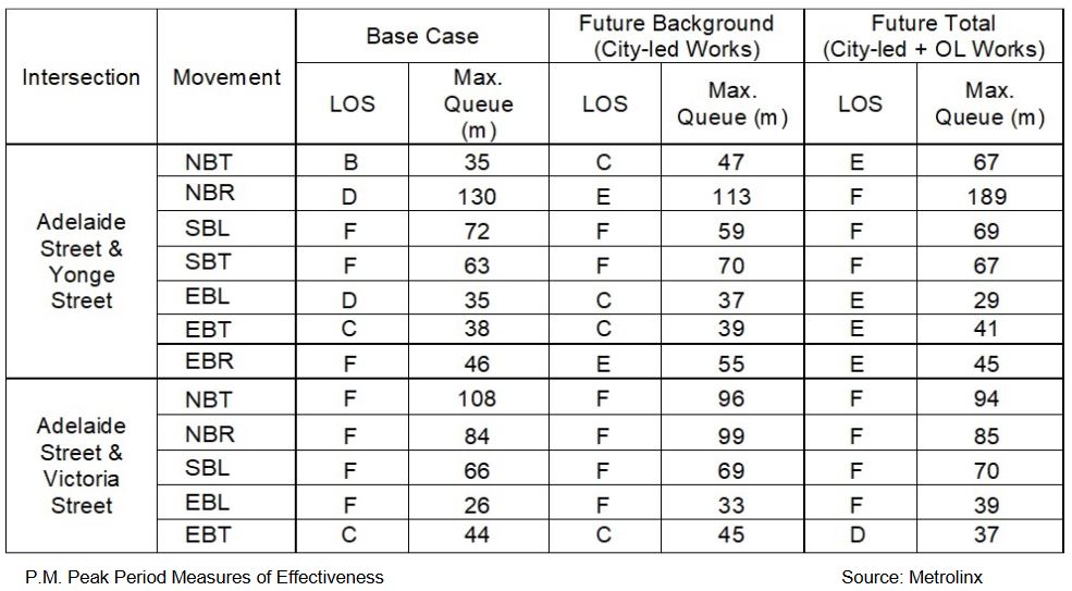
For each intersection and direction, the model also includes a “level of service” (or “LOS”) value. These range from “A” where traffic is free-flowing with no delays to “F” which is essentially a gridlocked situation where the demand so exceeds capacity that everything stops. A network might have isolated spots of level F at problem locations, but still work tolerably well overall. However, if many nodes have poor LOS values, the effect compounds because there is no relief anywhere in the network.
Appendix C: Level of Service Table
Here is a sample from this table. In the “Movement” column, the letters “T”, “R” and “L” refer to through, right turn and left turn movements. For Adelaide Street there is no westbound value because it is one-way eastbound. The “Max Queue” refers to the length of the traffic queue in metres on the approach to the intersection.
Some areas are already operating at a very poor service level, and they can hardly become any worse, although the duration of peak conditions will probably widen. Indeed, the concept of “off peak” when traffic regulations are not as severe will probably need to be reviewed to deal with “shoulder peak” effects.
Absent from this analysis is any indication of how transit service is supposed to operate under such congestion, and specifically how “priority”, such as there might be, will be possible if transit is stuck in traffic. An extended green time or turn signal is of no use if the bus or streetcar cannot reach the intersection. The report includes no discussion at all of the priority measures that might be implemented.
Another omission from the table are values for Church Street which will form part of the Queen car diversion, and more generally of the need for transit priority where streetcars will turn to and from Queen, Richmond and Adelaide Streets.
Toronto’s signal priority to date suffers from two major shortcomings:
- Only “standard” transit movements are considered, and there is no provision for turning priority at common diversion and short turn locations. This contributes to the delays encountered during major diversions and street closures such as the Toronto film festival.
- Transit only gets priority where there is thought to be surplus capacity it can use. At major cross-streets, the movement of traffic is considered more important than transit priority. In a highly congested network, priority could be difficult to achieve.
I asked the City of Toronto about how it would address some of these issues. Here is their reply.
Firstly, we are happy to confirm that we will be revisiting transit priority in the downtown along with signal timings in general, to try and ensure the transit network and general traffic movements can operate as efficiently and effectively as possible and that competing demands are managed. This work will also include transit diversion routes.
Secondly, on the subject of effective active intervention I’m sure you are aware of two programs that the City has rolled out, the traffic agents program and the pilot program on construction hubs. Both of these tools will be employed. Traffic agents will be used to help aid flow at crucial intersections and a construction hub will be established to ensure a high level of oversight and ensure coordination in logistical planning between Metrolinx work sites, City-led project work sites, developer work sites and any other works taking place on or adjacent to the public right of way.
Ashley Curtis, Director Transportation Planning & Capital Program, Email of Dec. 2, 2021.
Although it is outside of the study area, another City project that could affect downtown traffic in the Ontario Line construction period is the Waterfront East LRT. Although a good part of this work is on Queens Quay, there will be major work on Bay Street south from Union Station to the lake that would close this street.
Thirdly, Waterfront Transit is currently undergoing TPAP with a 30% design and report expected to go to City Council in 2022. As this work is not yet complete the project was not included in the modelling work. That said, the City of Toronto anticipates that work on the project will begin before 2030. We recognize the coordination challenges in the area and will continue to review timelines to ensure impacts are minimized.
Ashley Curtis, Email as above
Emergency Services
The report discusses alternate routes needed in some locations for emergency vehicles and access to parts of downtown. The area includes fire and ambulance halls, as well as hospitals.
More generally, there is a question of how emergency vehicles would be able to bull their way through traffic if congestion reaches the projected level. This is not addressed.
Haul Routes
For each site, there will be standard routes for trucks for the removal of excavated material, both enroute to and then from each site. Because all sites will be under construction simultaneously, all of this traffic will exist concurrently.
Here are sample maps showing access routes for Queen Station.
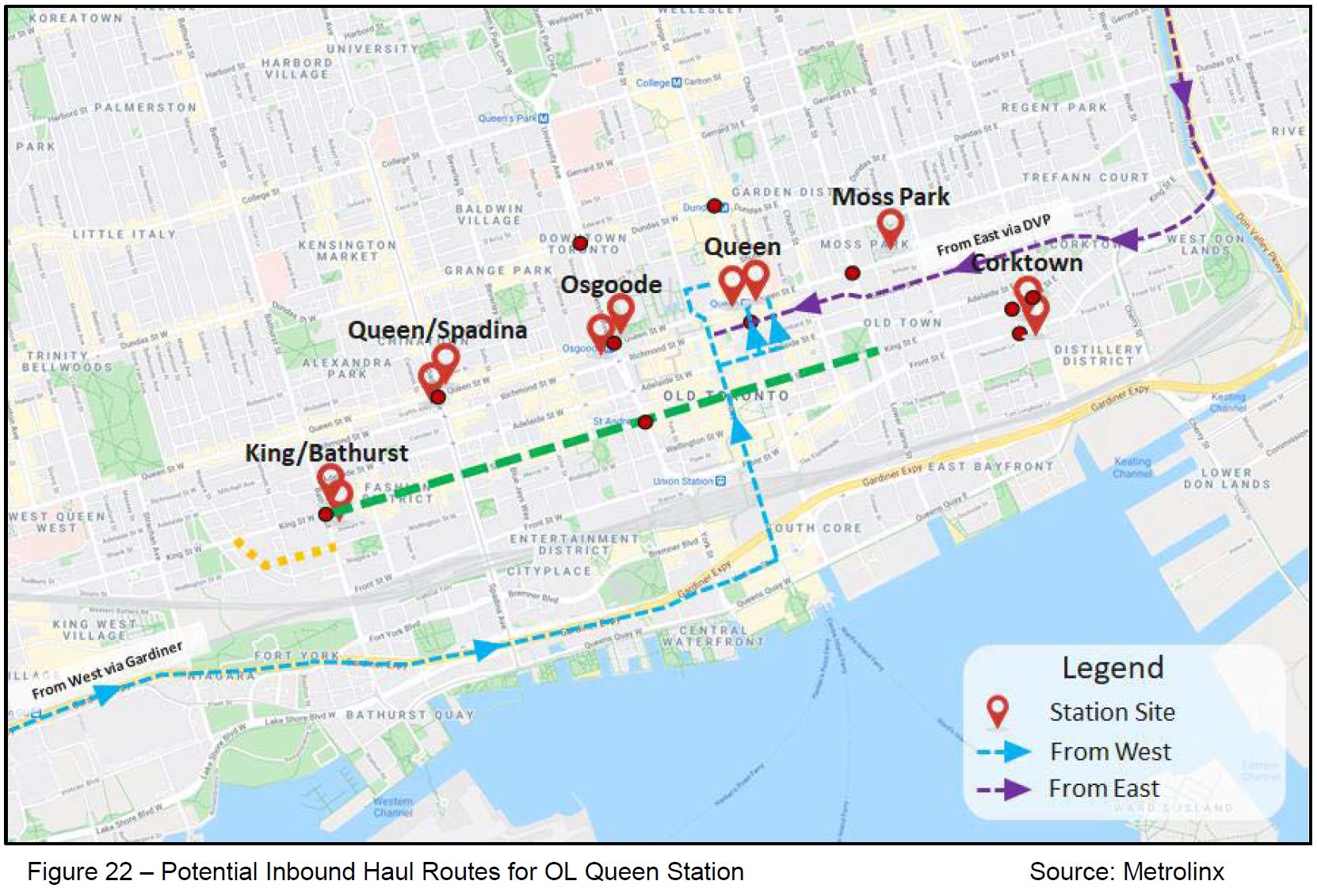
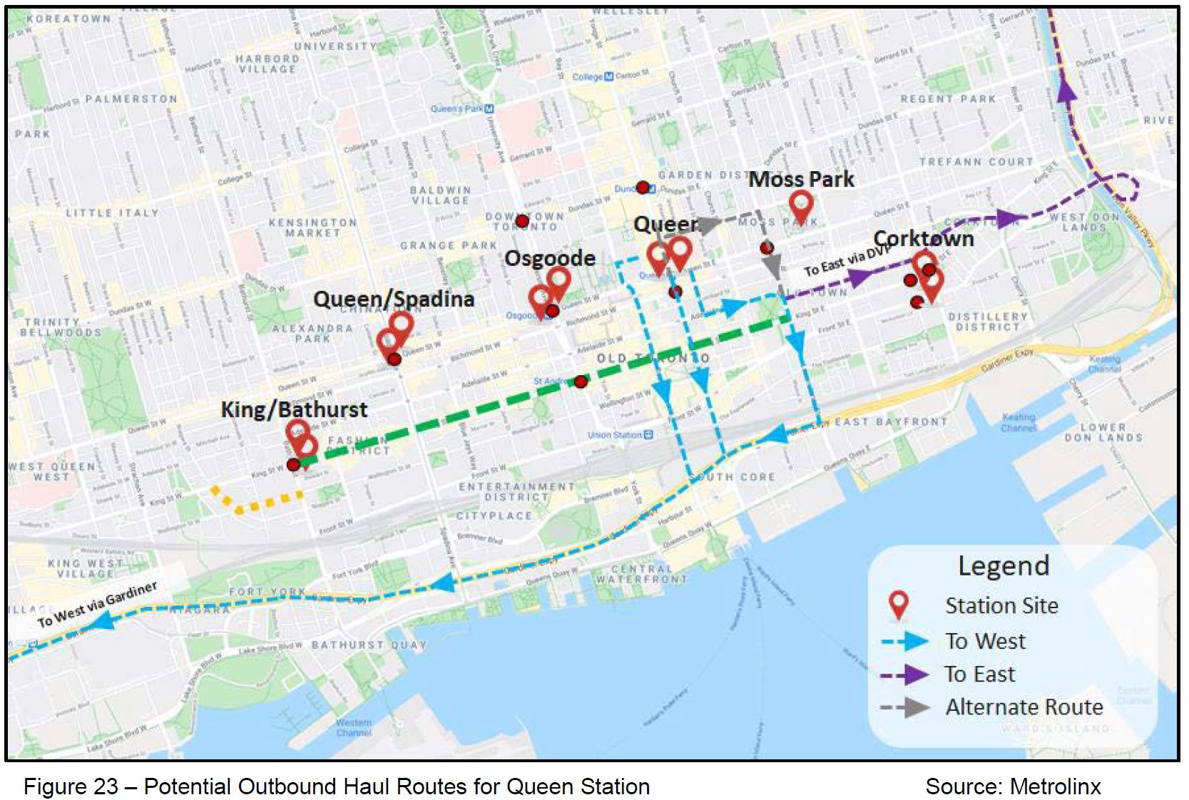
This activity should be seen for its aggregate effect across multiple sites, not just for each one in isolation. Certain key streets are proposed for access to and from sites including Bay, Yonge, Jarvis, Adelaide and Richmond.
The report is silent on the hours of work especially for stations that are in residential areas. Those who have survived construction on Eglinton Avenue know the level of intrusion that can occur, and that in a pinch, Metrolinx will work at all hours regardless of toothless City rules.
| Station | Spoil (m3) | Trucks/Day |
| King & Bathurst | 72,000 | 20 |
| Queen & Spadina | 90,000 | 25 |
| Osgoode | 96,000 | 25 |
| Queen | 90,000 | 20 |
| Moss Park | 80,000 | 20 |
| Corktown Station | 75,000 | 20 |
| East Tunnel Portal | 260,000 | 70 |
Pedestrians and Cyclists
City staff and Metrolinx are acutely aware that increased truck traffic on the haul routes potentially poses increased risk to pedestrians and cyclists. City staff will work with Metrolinx and Project Co. to implement strategies to ensure Vision Zero principles are followed and these potential risks are minimised.
The text above speaks to a major issue with this project: it will both constrain pedestrian and cycling space near major intersections, and it will introduce a level of heavy truck activity that is not normally seen there.
Where existing sidewalks are shifted to curb lanes, the space provided will range from 1.8 to 2.1m which may or may not accommodate the level of pedestrian demand. This must be a clear right-of-way for pedestrians that is not encumbered with superfluous street furniture, and it must be maintained clean and clear even though construction sites are often anything but.
The report repeatedly states that there will be little effect on cyclists at most locations because there is no designated bike lane today. This ignores the fact that cyclists use (mainly) the curb lane which will disappear in several locations. Moreover, some of the remaining lanes have streetcar tracks that cyclists avoid for their own safety.
“Project Co.” together with Metrolinx will supposedly “minimise” risks. Whether this will actually be achieved, especially under conditions of less than ideal weather and at night, remains to be seen.
The City talks a good line on Vision Zero, but there can be a huge gap between “minimising” and “eliminating” risks.

The emphasis with City Hall at this moment seems to be what problems will this construction cause for the all important single-occupant motorists.
Very little about the pedestrians. Little on public transit. Little on cyclists. Very little about pedestrians with walking problems. Whether it be walkers, motorized wheelchairs, shoppers with shopping carts, baby strollers, cyclists with flat tires, or those trying to locate where they moved the “temporary” bus or streetcar stops (and if they are still visible or not ripped down yet).
Worse for me if the transit apps accurately reflect the “real time” location of the next transit vehicle. If it app tells me the next one will come in 10 minutes, will I have time to pick up a hot chocolate to warm myself.
LikeLiked by 2 people
I mean, all of this is very easily solvable if downtown office employers just let everyone WFH permanently/semi permanently. No need to clog the streets to access jobs that can easily be done remotely. Leave the road capacity free for traffic that actually needs to be there like construction, 911/EMS, deliveries etc. But, “culture” and “collaboration” blah blah blah. Yes I know, the city can’t dictate what employers do or don’t do. But congestion is a self inflicted problem in this age of incredible telecommunications.
Steve: Without all those office workers, a lot of the activity downtown evaporates. Also WFH has its limitations. What could well happen is that the average employee spends less time “at work”, but the same number of spaces are occupied by more people in rotation. If that happens, the transit demand does not go away.
LikeLike
Needless to say, places that actually care about human life have devised ways of safely handling pedestrian and bicycle traffic through construction sites. Here are some videos of such access:
And sometimes a temporary bridge is built to get people through construction sites. see:
When I watch videos from places that routinely do things right I experience a variety of emotions. Those emotions start with eye-rolling and face-palming, but soon escalate to a fairly high level of anger. There are well-known ways of doing this construction safely. So I get angry at those people who have such a callous indifference to human life that they choose to do things in a way that is grossly unsafe.
LikeLiked by 2 people
There doesn’t appear to be any large scale mitigation that could be used. For example:
Congestion zones could reduce the amount of traffic in the core, and help fund the DRL.
Increased transit – more buses and streetcars could help move people from vehicles to transit.
Shutting roads to cars – similar to what was done on King – but with more support for bikes and pedestrians given that the road will be unusable for anything but local traffic anyways.
One ways or increased limits on turns, shutting side streets and removal of stop/lights where possible.
Steve: An issue with auto traffic in the core is that the vehicles do not necessarily originate in locations where more service on routes serving the core will make a difference. A relatively small portion of commuting trips (pre-pandemic) came into the core by car and so there are not a lot of trips to displace onto transit to start with. The basic problem is that when a significant chunk of capacity is removed, what’s left cannot handle the demand.
I am particularly concerned that the effects of the city-led projects have been greatly overstated, and hence the total effect, by modelling many years’ work as if it all happened at the same time. There is no question there will be problems, but the lack of fine-grained modelling for a multi-billion dollar project says something about the effort expended on analysis.
Someone is bound to say “why do we have to replace that streetcar track” or “why do we have to rebuild that sewer”, and it’s a short step to deferred maintenance.
LikeLiked by 1 person
And much of this devolves to over-extensions of subway spines in to suburban areas, or less-dense areas and foregoing smarter investments in heavier transit in the core eg. a Queen or King or Front St. transit service which would enable fast transit from base of High Park, a pinch point from 1949, to the denser core. And by not having smarter transit in the more correct places we cannot move on having a car-reduced car, or at least it’s not as fair as having the example of say London, where along with a congestion charge/restrictions, there was a real boost in transit provisions, atop the good subway already there.
A car-free or reduced car/tolled zone would be a good goal, and many other cities would have moved on this, somewhat, but we’re a bit too carservative/carrist/carrupt, though of course the cars are at times very useful.
Another option is to re-think the plan(s). Or schemes.
What would happen if we had a straight-line approach through the core following the street grid far far more? Why the duck up to Queen, then back down? Is it real demand, or is it an imposition to show how City Wall at Queen St. is a Problem, or destination? Or does the mislocation of the new Court house mean another compounding error?
Questions, but no answers.
Too bad we didn’t do that 1957 plan for twice the Relief two decades ago eh?
LikeLike
The Report notes several “City-led projects” – as you note these only go to 2026 but we (or I) do not know if these actually include all that will or could seriously affect downtown traffic. You already note that they have ignored the King Street work planned for 2024. I can understand why they cannot really list projects after 2026 but what else have they left out? The (excellent) TOInView site has still not added 2023 projects – ideally they would add all those up to 2026.
Steve: This is explained in a comment from the City in a “Part VI” article that will be published later today.
LikeLiked by 1 person