
Recently, I wrote about a very unsatisfactory online meeting of the Stakeholder Advisory Committee for waterfront east transit. Little came of that meeting beyond a sense that nothing will happen soon to improve transit in the area.
The big news, which was not “news” at all given the media coverage, was that $3-billion had been secured from the City, Province and Federal governments toward the project. Predictably, in the absence of any details, this produced a shower of questions about why such a sum would be spent on a short line and whether that amount would actually be enough to finish the project.
Planning for and development of the eastern waterfront dates from an era when new buildings could be sold as quickly as they were built. This extended all the way from Yonge Street out to the Don River and the massive plans for the East Harbour Station area. Transit demand projections originally assumed a mix of residential and commercial development particularly at East Harbour, but the commercial market collapsed and residential growth is at nowhere near projected rates and time frames.
Toronto always talked of the waterfront as a “transit first” development, but actual delivery falls way short of that goal. Queens Quay East has a mix of infrequent bus services, and access to the city north of the rail corridor is throttled by traffic on limited crossings. The proposed LRT corridor might exist on plans, but bus rapid transit (BRT) as an “interim” solution always lurked in the background. That might be credible if there were a clear transit corridor to the Union Station area, not to mention street capacity to handle buses and riders, but these problems have never been discussed in waterfront plans.
If we cannot get transit “right” in a brand new community, how can Toronto hope to shift existing neighbourhoods away from cars?
Those who have followed this project through many false starts and changes over the years know that this is not a straightforward “streetcar line” extending from Union Station into the planned community on the island now called Ookwemin Minising. Both through delays and added complexity in some components, the price tag keeps rising, but we have yet to see a consolidated budget or a description of just what it will pay for.
There are beautiful drawings of a future city on the water, but no clear transit plan.
This article reviews the major components of the waterfront east proposal, the many outstanding issues, and options such as there may be for getting better transit to an underserved area.
For those who just want the conclusion, here is my take on the current situation.
- Previous public consultation sessions gave the sense that plans were heading to a point where in early 2026 there would be construction staging options and a better handle on the project budget. Instead we seem to be going backwards with more uncertainty on the timing and scope of work, and exactly when there will be streetcar service to the eastern waterfront.
- Development proposals have consistently run ahead of the provision of frequent, reliable transit service.
- There is an undue focus on getting connectivity to the new developments from the west as a top priority causing the northern link (via Cherry to King) to be placed on the back burner.
- It is clear that the overall project is constrained by available funding and by the cost of rebuilding Union Station Loop. It is also possible that Union Loop will not reopen in time for first occupancy in the new Ookwemin Minising neighbourhood thereby providing less than ideal transit service to a new “transit first” neighbourhood.
- Transit ridership projections for the eastern waterfront date from the era when substantial commercial development was planned, and this boosted the expected peak demand.
- Development plans, and hence future demand, will be affected by proposals for a much-expanded Island Airport, but we do not know the scale of the effect.
- The continued lack of a staging plan makes discussion of interim service configurations over coming years almost impossible.
The project planners appear to have made up their mind on at least part of the staging plan without fully explaining how it will work, or the “why” behind options chosen. The momentum of 2025, the sense that real work was imminent, has been lost. We now have $3-billion “in the bank”, but with no clear idea of what it will buy, what elements will be missing on opening day and what future completion of the project will cost.
The rebranding of the “Waterfront East LRT” into the “Waterfront East Rapid Transit Line” speaks of desperation and a desire to avoid the “LRT” moniker now poisoned by botched implementations on Finch and Eglinton (Lines 6 and 5). This is most definitely not a “rapid transit line”, it is a streetcar on its own right-of-way. What Toronto needs is honesty about waterfront transit, leadership and real progress on construction.
The Evolving Plan
The map below, taken from a report to the City’s Executive Committee in May 2025, shows the Waterfront East project development plan as it existed a year ago.
Segment 1 is the TTC’s design responsibility, and is the most complex requiring major expansion of Union Station Loop, some new facilities at Queens Quay Station, and the new eastern portal bringing the line to the surface just west of Yonge Street.
Segments 2 and 3 have been designed by Waterfront Toronto and they are both surface running. Segment 2 would mirror what we already see on the western leg from York to Spadina, albeit with some changes to implement “lessons learned” from the existing line. Segment 3 would link south to the new island (then called Villiers Island as a placeholder before it became Ookwemin Minising) ending just west of the Commissioners Street bridge over the newly aligned Don River. A northern branch would connect to the existing network at Distillery Loop.
See previous articles for details as the design evolved:
- Waterfront East Design Update (June 2025)
- Waterfront East Update: October 2023
- Waterfront East LRT Update: April 2023
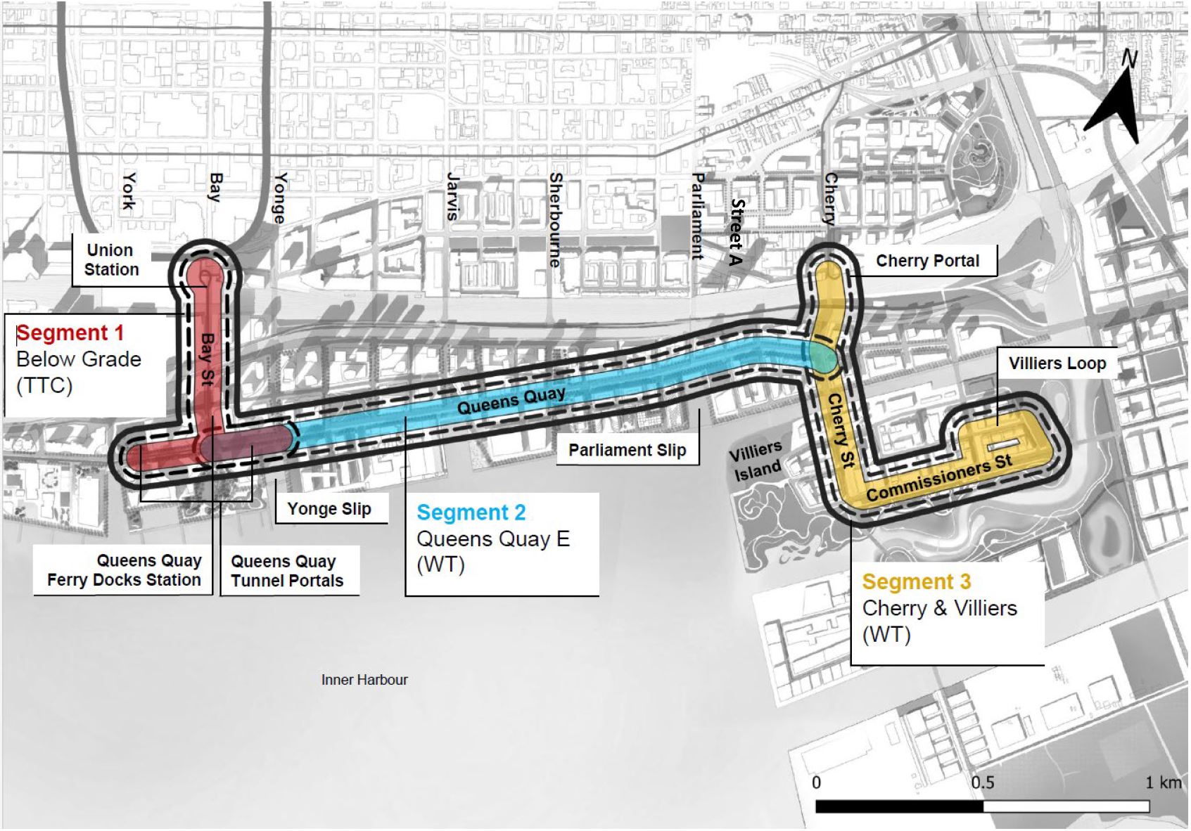
In its full original plan, the waterfront network also included future connections east via Commissioners Street to Leslie Barns, and north via an extended Broadview Avenue to connect with East Harbour Station on the Ontario Line. Also proposed was an extension to the north side of the Ship Channel. Note that these would require twinning of the new bridges on Commissioners and on Cherry crossing the realigned river. This was planned originally, but cut early in the project as a budgetary saving.

Over the years thanks to design refinements and cost creep, pieces have fallen off of this plan, at least in the sense that they are now projected for the indefinite future, if ever.
The project’s current goal, as stated in the Strategic Advisory Committee (SAC) meeting, is:
[…] project scope within the $3B funding envelope to enable the start of transit service aligned to first occupancy on Ookwemin Minising in the early 2030s.
Specifically, the intent is to bring transit service from the west to the new neighbourhood by about 2032, but not necessarily with a Union Station connection. The Cherry/Distillery connection has been pushed out even further. This is hardly the kind of waterfront transit service Toronto has been promised over many years.
Demand pattern
The projected travel demand on the Waterfront East line included home-to-work trips from the waterfront, but also strong demand headed to destinations in proposed commercial developments. Indeed, the travel to work locations would be stronger and occur in a shorter time period than travel from the residential buildings. This is a common pattern in transit planning. With the change in market demand for office space, the eastern waterfront is now expected to be almost entirely residential. This affects the trip demand pattern, but also affects the amount of parking needed, assuming that it will be hard to sell medium to high density residential if there is only poor transit to serve it.
It is not clear whether the leisurely approach to improving transit recognizes the original “transit first” premise of the waterfront, or the strong incentive for car travel from a location at the junction of the Don Valley Parkway and the Gardiner Expressway. I am reminded of fantasies of the Sheppard East corridor and subway encouraging transit use in spite of widely-spaced stations, and the siren call of the 401/DVP nearby.
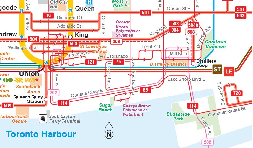
The target for first occupancy on Ookwemin Minising is 2032, but it will take some time afterward for the full build out. Meanwhile, development on Queens Quay continues including the Quayside parcel near Parliament and other lands nearby. Many people have lived along Queens Quay for years, but their transit service is a collection of infrequent bus routes (114 Queens Quay, 85 Sherbourne and 65 Parliament) only one of which connects to the business district and Line 1. (Route 202 Cherry Beach on the map below is seasonal.)
An important factor in serving the waterfront is the barrier created by the rail corridor, not to mention traffic congestion for access to the Gardiner Expressway. The Queens Quay red lanes were implemented specifically to deal with Gardiner-related road congestion.
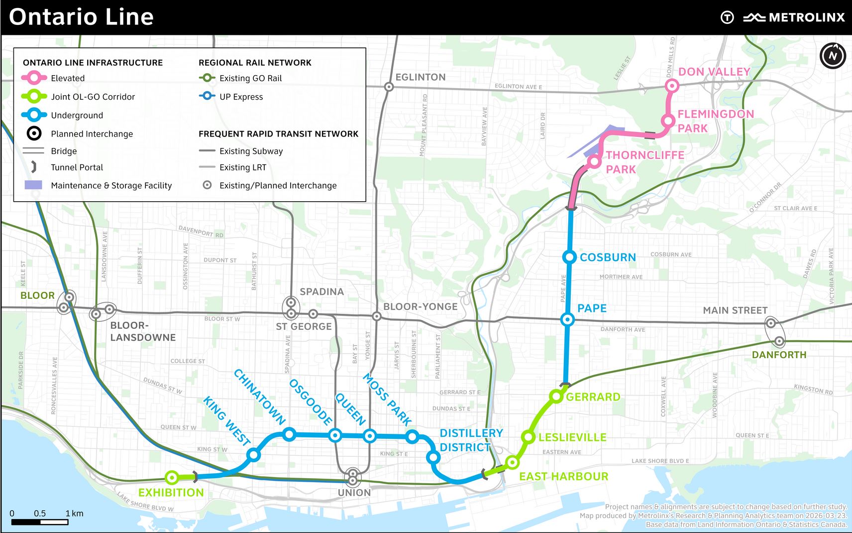
Not shown on the map above are the future Ontario Line Distillery District (King & Parliament) and East Harbour stations. Both of these are comparatively remote from development on the waterfront, especially on the new island. The question of a Cherry Street station on the OL comes up routinely, but that ship has sailed, to mix metaphors, as there is no provision for this in works already underway.
The proposed expansion of the Island Airport to serve jets and to massively increase its capacity would severely affect the attractiveness of the eastern waterfront for new housing and limit its scale.
This appalling scheme ignores all other waterfront uses and development existing and planned, but could have a major effect on ridership for both the eastern and western legs of the waterfront network.
A key part of any transit planning for this area will be an updated demand projection together with more details on the expected build-out in each neighbourhood.
Planned Work in 2026-27
The project is not exactly speeding ahead. Here is the work plan for 2026 and early 2027 according to the presentation at the May 2026 SAC meeting:
- Between City of Toronto, TTC, and Waterfront Toronto, develop a governance model to enable project delivery
- Specify project scope within the $3B funding envelope to enable the start of transit service aligned to first occupancy on Ookwemin Minisingin the early 2030s.
- Begin construction on Early Works
- Report back to Council in early 2027
The early works referred to here will make provision for a future substation. It is not yet clear when the major work of reconfiguring Queens Quay East will begin.
Budget
The recently announced $3-billion is a huge sum for a short line, and much will be consumed by rebuilding and expanding Union Station Loop and creating a three-way junction under the Bay & Queens Quay intersection.
Over time, some originally proposed aspects of the Waterfront East plan have “fallen off of the map” thanks to budget limits:
- Decorative portals at Queens Quay were dropped.
- Expansion of Queens Quay Station to increase streetcar and passenger capacity have been dropped, notably any new connection to the Ferry Docks.
- The connection north from Queens Quay via Cherry to Distillery Loop, providing a link to King Street.
The Union Loop expansion is still largely intact, and it is essential to handling the combined demand of the Harbourfront west and east services. The proposed layout includes double-tracking both the northbound and southbound tunnels so that cars on each route can bypass each other and avoid delays at the loop. This is already a problem with the 510 Spadina and 509 Harbourfront cars to the point that for the duration of the World Cup games the 510 has been banished to leave all capacity at Union for the 509.
There has always been provision in the plan for a branch to the west just south of the rail corridor. This would run through a space in the basement of the Air Canada Centre and surface on Bremner west of York Street. There is no space for a reserved pair of streetcar lanes along Bremner, let alone platforms at stops, and the area is regularly congested by events at the Rogers Centre and the general backlog of Gardiner Expressway bound traffic. This option should be dropped from the plan if it hasn’t been already.
At Queens Quay Station, original plans called for longer platforms to allow multiple cars to serve the platforms, but this has been cut. Also unresolved is the knotty problem of links from the station across Queens Quay to provide access to the Island Ferry terminal.
Any Ferry Docks link would have to dive under the streetcar tunnel or run overhead. Neither of these is easy to provide both because of existing buildings and the limited space for stairs, escalators and elevators. Current planning appears to have simply put off work at Queens Quay station for another day (and another budget).
At Cherry Street, the planned twinning of the road underpass at the rail corridor has been put off until (at least) construction on the GO Expansion, Ontario Line and Gardiner/DVP realignment projects are all out of the way likely in or shortly after 2030. This link is now seen as a future project and is not included in the $3-billion base budget and will require separate funding.
This decision precludes an early link from the line to King Street as an alternative, pro tem, to use of the Bay Street tunnel while Union Station is under construction.
Rebuilding the Bay/Queens Quay Portal
The existing structure between Queens Quay Station and the western portal (east of York Street) will be rebuilt to include curves to the east and through track so that cars could run east-west on Queens Quay without going to Union Station. Conversion of this structure to provide for east-west service can occur before and independently of the work at Union Station in order to restore streetcar service to the waterfront as quickly as possible.
Ideally the new eastern portal and trackage on Queens Quay east of Bay should be built to the degree possible without shutting down streetcar service to the west. This should minimize the time needed to break through into the existing tunnel and provide an east-west link. Whether this is part of the construction plan is unknown.
Another issue will be the nature of replacement service while streetcar operation to Union is impossible. Bay Street is very congested, and any surface bus will have to loop through the congested streets east and north of Union Station. Indeed it is not clear if expansion of Union Loop can be achieve without some removal of surface lanes to access the structure from above. The City will have to think very hard about how already inadequate road capacity will be parceled out.
Through routing Harbourfront cars to Queens Quay east will require a terminal. Depending on timing, it is not clear that the future loop on Ookwemin Minising will be practical and even available when streetcars need it. This is another reason why the deferral of the Cherry/Distillery connection limits options for interim service at least to the developed parts of Queens Quay East.
Realigning Streets
Both the Yonge and Parliament Street slips will be reconfigured to support the Waterfront East line, and some of this work is already under way.
At Yonge Street, the northern part of the slip will be filled, and access to the Harbour Castle Hotel will change from the north to the east side of the building. This allows construction of the east portal at Bay and Queens Quay which will block the existing main hotel entrance.
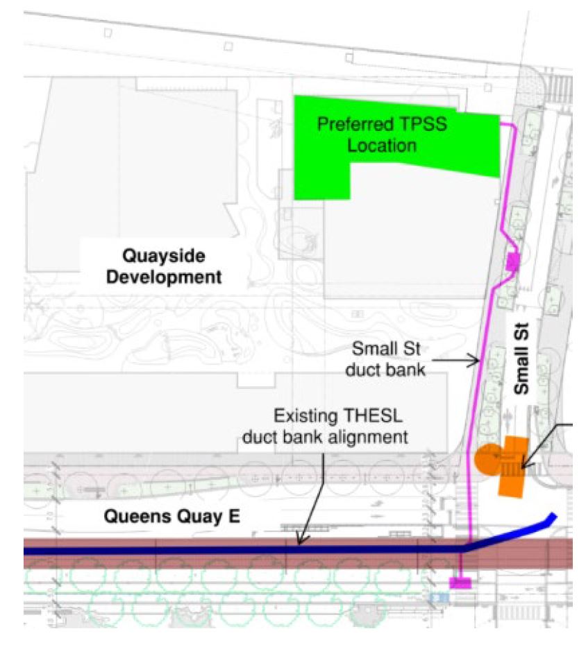
At Parliament Street, the northern part of the slip has been filled to square it off and allow realignment of Queens Quay to travel straight east to Cherry rather than the dogleg it now makes between Small and Parliament Streets. Parliament will be extended south to meet the realigned Queens Quay.
The image below shows the existing alignment of Queens Quay and Parliament. Note that Parliament Slip has been partly filled to provide a route for a realigned Queens Quay that will run north of the Victoria Mills silos (centre of image) and connect to the New Cherry Street. The future transit right-of-way and bridge over the Keating Channel are already in place.
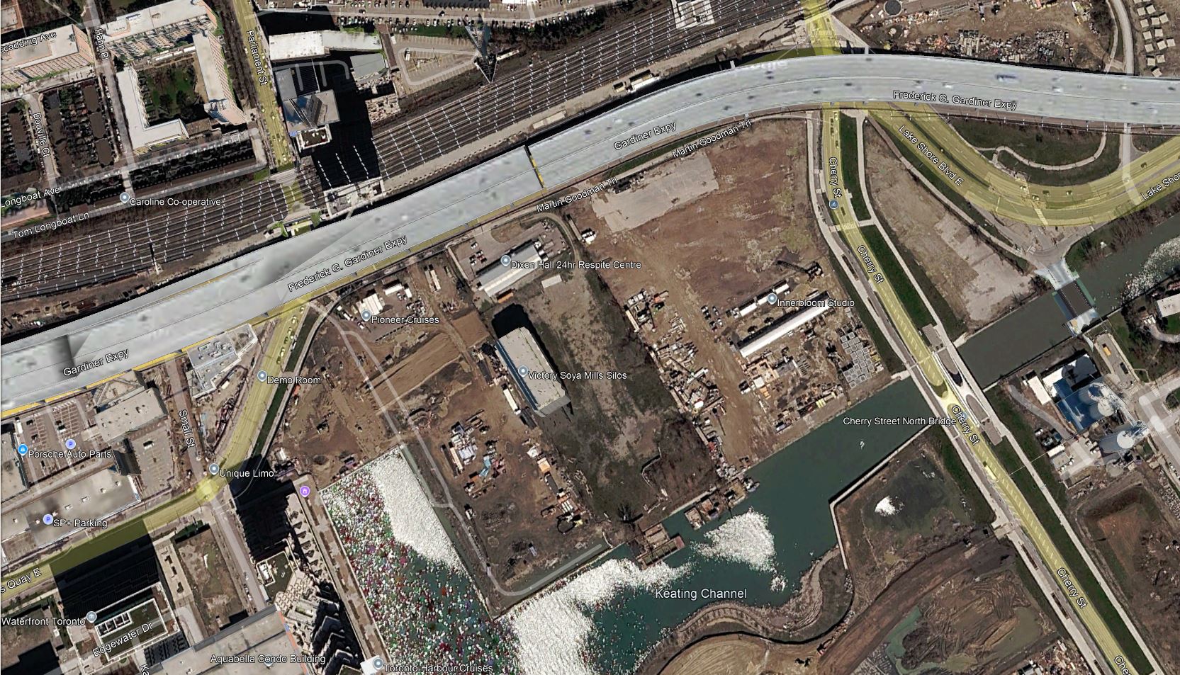
At Cherry, space has been left for the future northern link to Distillery Loop, but this will not actually be built as part of the base project. The loop itself will disappear when the through connection to Queens Quay is finally built.
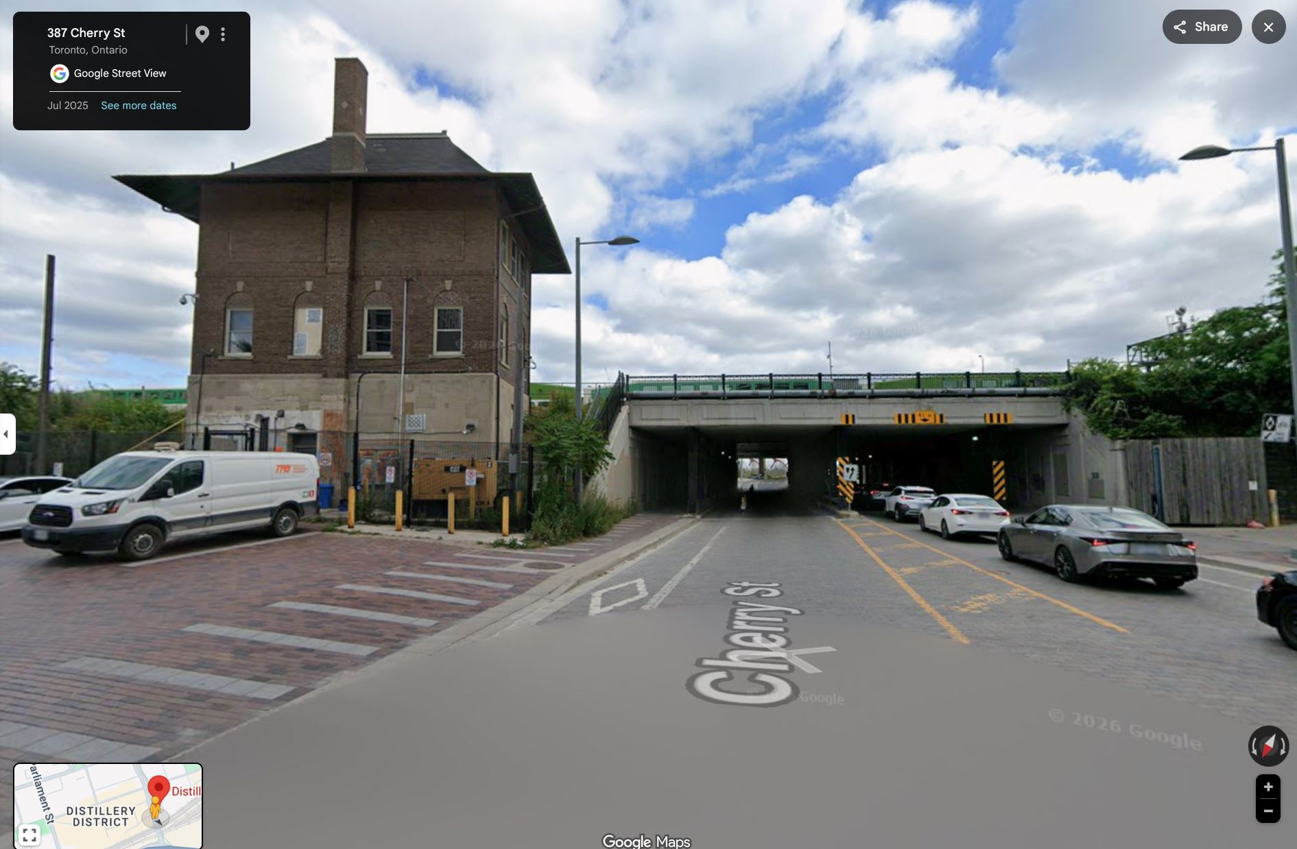
A related project will be the relocation of the old Cherry Street signal tower south of Distillery Loop. This tower houses the old manually operated interlocking plant for the eastern approach to Union Station, but it is no longer required. Plans are for it to be relocated and preserved, but this has not actually happened yet.
The view through the existing underpass shows that a new passage under the tracks is not trivial because of the rail corridor’s width.
Conflicting Projects
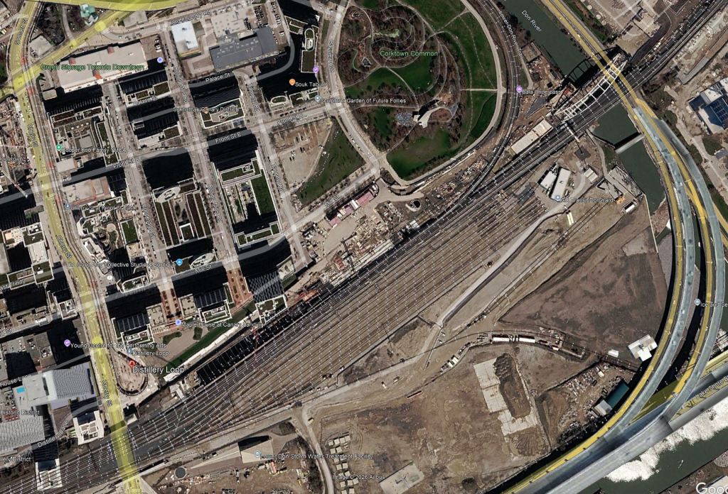
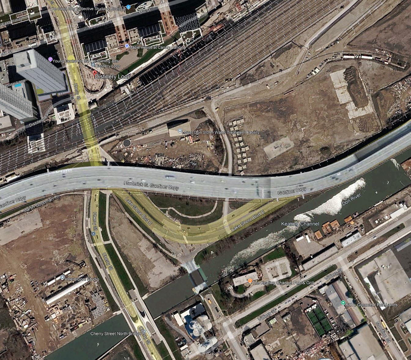
Three major projects are underway or planned that can conflict with construction of the Cherry Street link. That said, nothing prevents as much work as possible taking place in advance. However, with this link now put on the back burner to save money, nothing will happen beyond the bare minimum to preserve this option as a future project. The Cherry link as originally proposed is shown in the map below.
Ontario Line
Between Cherry Street and the Don River, the Ontario Line will rise from underground to a new bridge recently installed over the river. Until this work progresses to the point where it does not conflict with TTC work at Distillery Loop, the route south from the loop is blocked. A related issue is whether the planned new site for Cherry Street Tower lies east of the loop on land now occupied for Ontario Line construction.
There is an excellent photo of the Ontario Line bridge at the Don River by kotsy on the Urban Toronto site. The view looks west from the east side of the Don Valley Parkway.
GO Expansion
Much work has occurred on the GO Lake Shore East corridor, and the proposed Cherry underpass cannot go ahead while work might conflict with GO activities above. At this point it is not clear what is left to do by GO in this area.
Gardiner/DVP Realignment
The Gardiner Expressway passes over Cherry Street south of the rail corridor. It has yet to be rebuilt and realigned as part of the overall Gardiner reconstruction. This work is supposed to complete in roughly 2030, but it is unclear whether work will be accelerated when the Province takes over responsibility for the expressway in October 2027.
Alternate Routes
From time to time, the idea of a connection from Queens Quay to King Street via Parliament surfaces in various forums. This would not be as easy at it seems because:
- Parliament is only four lanes wide at the rail corridor and the underpass cannot be widened to provide reserved streetcar lanes.
- The clearance at the rail underpass is only 4.2m, less than the now-standard 5.0m.
- The geometry of the King/Parliament intersection precludes curves in the southwest quadrant.
Although there is a proposed connection via an extended Broadview Avenue to East Harbour Station and Queen Street, this is in the long-range plans and would require advancing major works to build out the road and transit infrastructure (extension of Broadview south to Commissioners, relocation of high voltage hydro towers on Commissioners east of the Don River, twinning of the Commissioners Street bridge over the Don River). This is not a short term option.
What About a Subway or Elevated?
Grade separated options for waterfront transit appear now and then, and were even considered, briefly, as a replacement for the streetcar extension. There are major problems with going above or below ground.
- The proposed surface stops on Queens Quay are at Freeland (east of Yonge), Dockside (east of Jarvis), Small Street (west of Parliament) and at Cherry. The cost of stations would almost certainly dictate that some be deleted from the plan, and this would reduce the route’s benefit as a local service.
- Construction of a streetcar subway tunnel immediately north of Lake Ontario would be complex.
- Transition between the existing surface network and an elevated structure would occupy space that would otherwise be part of a beautified streetscape, and elevated stations would occupy considerable space for platforms and vertical access.
- Any attempt to continue a grade separated structure to the north would have to deal with the rail corridor, a significant physical barrier.
Despite the Ontario government’s love for subways, this option is not on the table because it is impractical. Moreover it does not address the largest cost element, the expansion of Union Station. Instead a grade separated waterfront line would push costs even higher.
