
Much attention regarding transit priority in recent months focused on the RapidTO red lanes for 29/929 Dufferin and 510 Bathurst, and on traffic signal timings for 6 Finch West, 5 Eglinton and a few intersections on 510 Spadina. Another change with less fanfare was the modification of parking and stopping restrictions on Dundas Street West between Dovercourt and University.
Council approved these changes in two groups. The first was for the area between Spadina and McCaul, and the second extended this east to University and west to Dovercourt.
- May 2024: Temporary Parking and Traffic Amendments – Dundas Street West
- December 2025: Transit Priority Measures to Support the 505 Dundas 6-Minute Network
In a previous articles, I reviewed the effect of changes on 7 Bathurst between Bathurst Station and Eglinton, and on 511 Bathurst and 29 Dufferin south from Bloor.
This article continues the series with a review of changes on Dundas Street West.
A few noteworthy points:
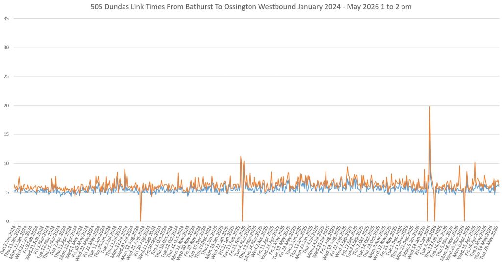
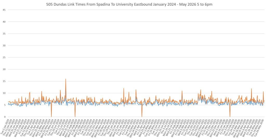
- Over the 29 month period of this review there has been little change in travel times, although there are some specific seasonal and weather-related spikes and dips.
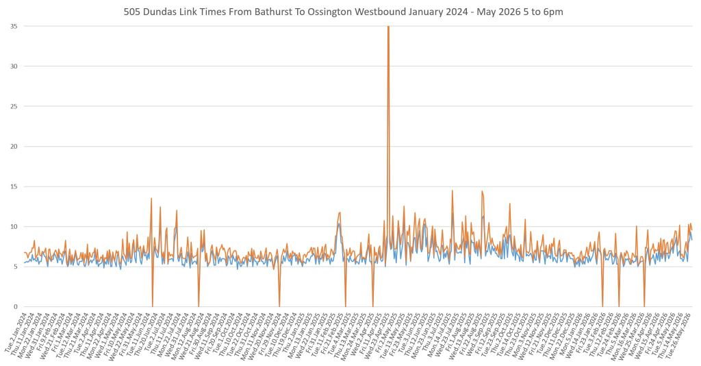
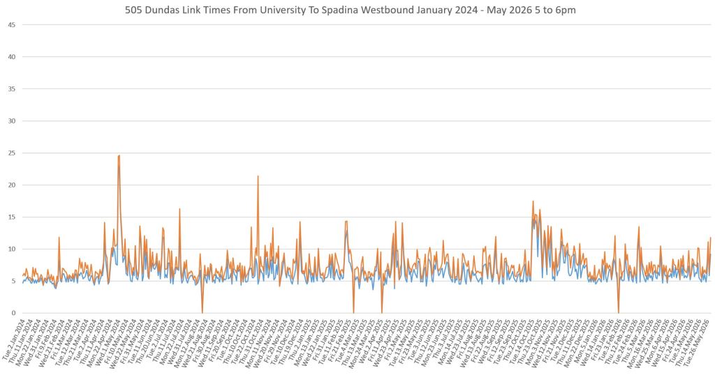
- Peak period, peak direction shows more variation than off-peak, especially westbound in the PM peak.
- Extended travel times do not occur only in the “downtown” part of the route, nor only in the peak periods. Attempts at transit priority that focus only on the core and the peak periods will not address issues at other times and locations.
- There are quite striking “heartbeat” patterns in the data where the highest values usually fall on the same day of the week:
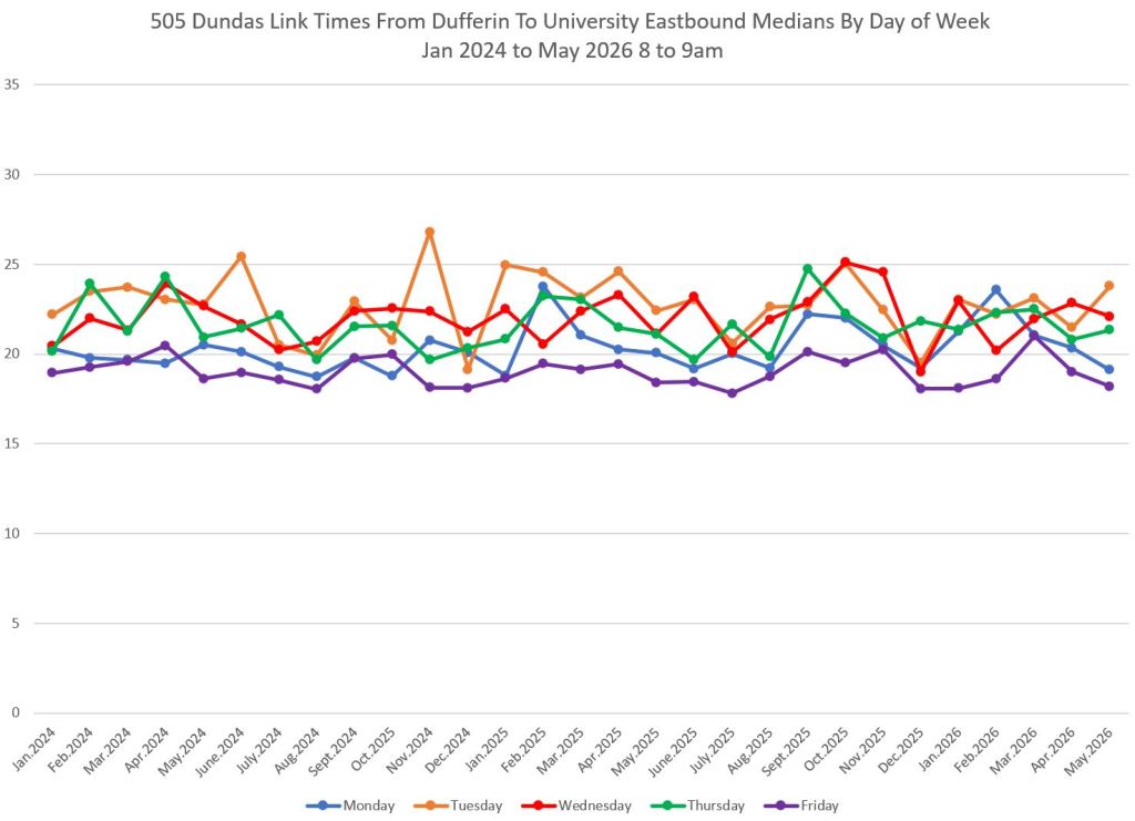
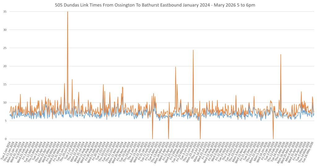
- AM peak eastbound: The spikes tend to be on Tuesday or Wednesday. This corresponds to a known pattern that developed during the pandemic that midweek traffic was higher than the ends of the week.
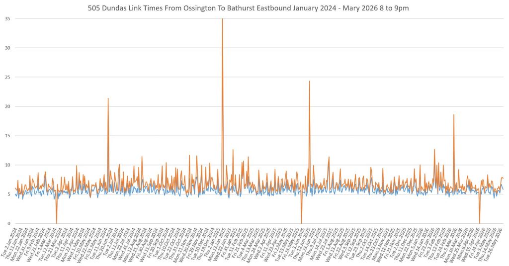
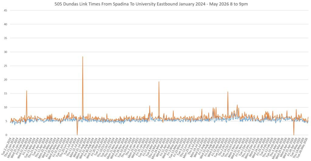
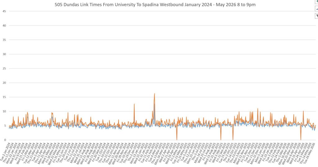
- Early and late evening eastbound: The spikes tend to fall late in the week on Thursdays and Fridays. A similar pattern shows up in the late evening westbound.
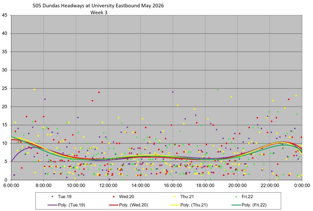
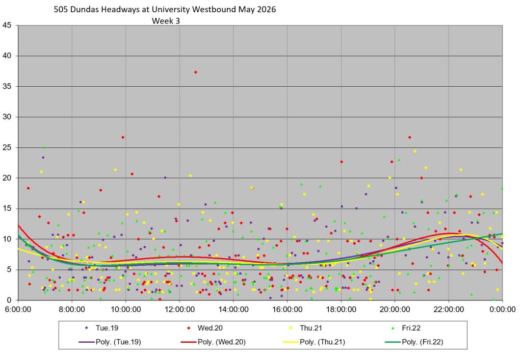
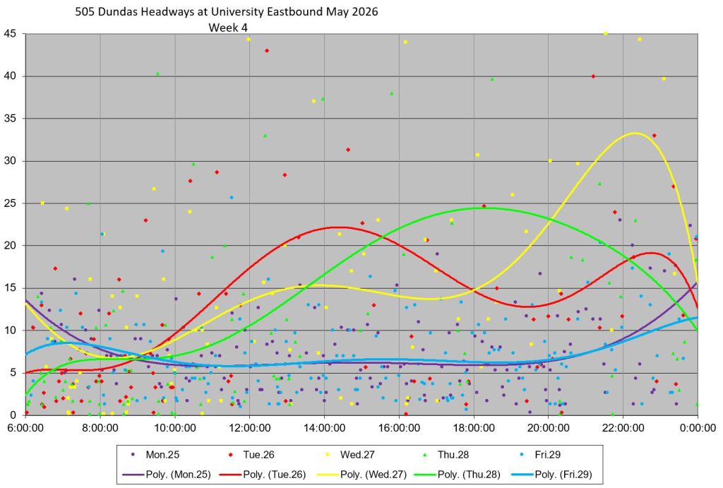
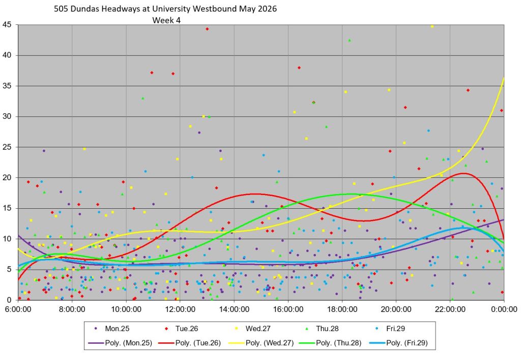
- Although travel times are fairly consistent, they only measure the service that actually shows up. At the end of the article are charts showing headways (the interval between streetcars) both ways at Dufferin, Bathurst and University in May 2026. Travel times might be consistent and even slightly improved, but the overall service quality remains uneven.
Traffic Regulations
The table below summarizes the changes implemented on various sections of Dundas. The 2024 revisions were intended to be temporary in reaction to construction on Spadina, but they were subsequently made permanent. Most of the changes only affected the peak periods in the counter-peak direction because peak direction restrictions were already in place.
| Location | Previous | Revised (Changes in Italics) |
|---|---|---|
| Enacted May 2024 | ||
| Spadina to McCaul | ||
| Eastbound | 7:30 to 9:30am: No Stopping 3:30 to 6:30pm: No parking Parking allowed at other times | No Stopping at all times |
| Westbound | 7:30 to 9:30am:No parking 3:30 to 6:30pm: No Stopping Parking allowed at other times | No Stopping at all times |
| Enacted December 2025 | ||
| Dovercourt to Ossington | ||
| Eastbound | 7-9am: No Stopping Parking allowed at other times | 7-9am & 3:30-6:30pm: No Stopping Parking allowed at other times |
| Westbound | 3:30-6:30pm: No Stopping Parking allowed at other times | 7-9am & 3:30-6:30pm: No Stopping Parking allowed at other times |
| Ossington to Augusta | ||
| Eastbound | 7-9am: No Stopping Parking allowed at other times | 7-9am & 3:30-6:30pm: No Stopping Parking allowed at other times |
| Westbound | Parking allowed | 3:30-6:30pm: No Stopping Parking allowed at other times |
| McCaul to University | ||
| Eastbound | 7:30-9:30am: No Stopping Parking allowed at other times | 7:30-9:30am & 3:30-6:30pm: No Stopping No Parking at other times |
| Westbound | 3:30-6:30pm: No Stopping Parking allowed at other times | 7:30-9:30am & 3:30-6:30pm: No Stopping No Parking at other times |
Left turn restrictions were changed at some locations:
| Location | Previous | Revised |
|---|---|---|
| Enacted May 2024 | ||
| Dundas & Spadina EB & WB | 7:30-9:30am & 3:30-6:30pm Weekdays | 7:00am-10pm All Days |
| Enacted December 2025 | ||
| Dundas & University EB & WB | 7:30am-6:30pm Mon-Sat | 7:00am-7:00pm Mon-Sat |
Travel Time Effects Between Dufferin and University
Note: Although the bylaw changes only extend west to Dovercourt, the data below includes the section from Dovercourt to Dufferin. The reason for this is that I have been tracking Dundas for many years with screenlines at major streets of which Dufferin is one. For consistency, I have used the same screenlines here. Following sets of charts review individual segments between Dufferin, Ossington, Bathurst, Spadina and University.
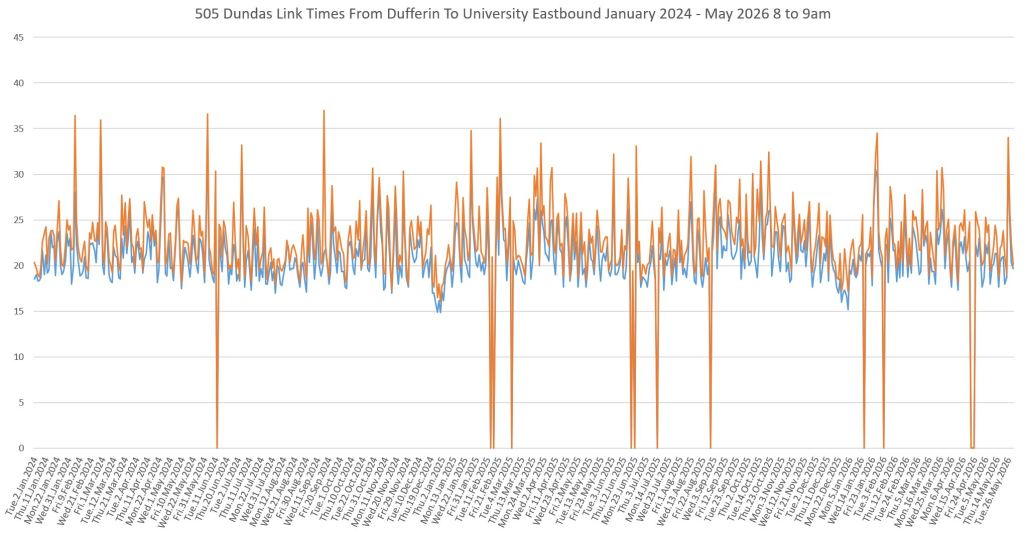
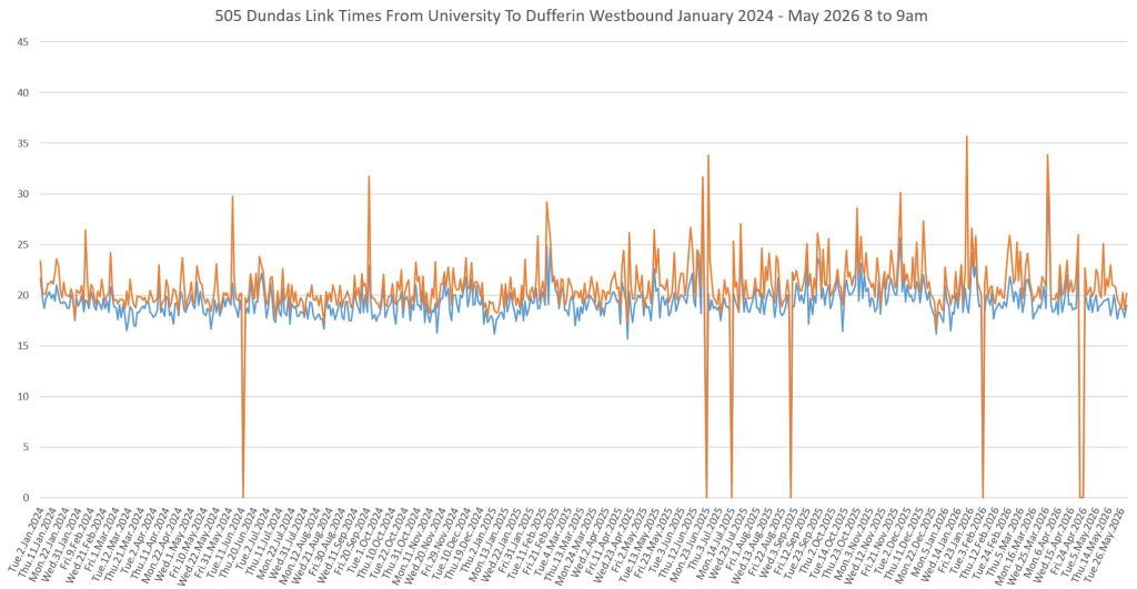
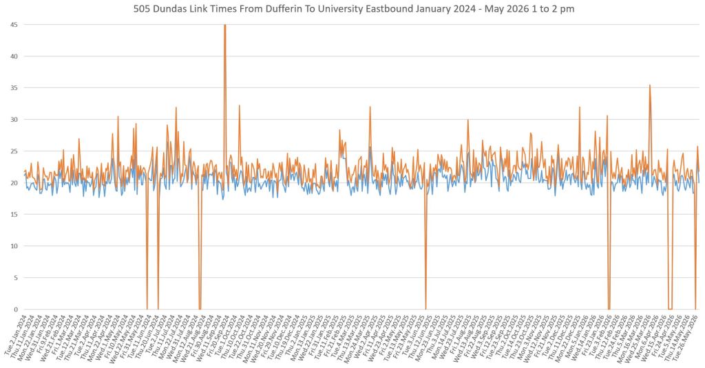
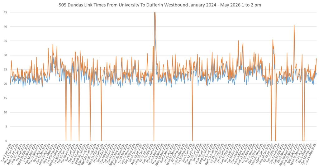
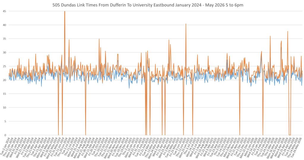
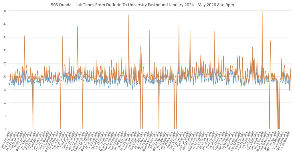
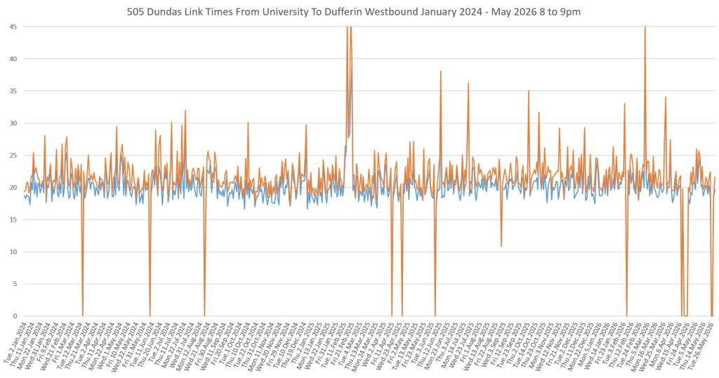
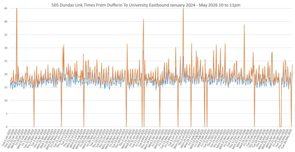
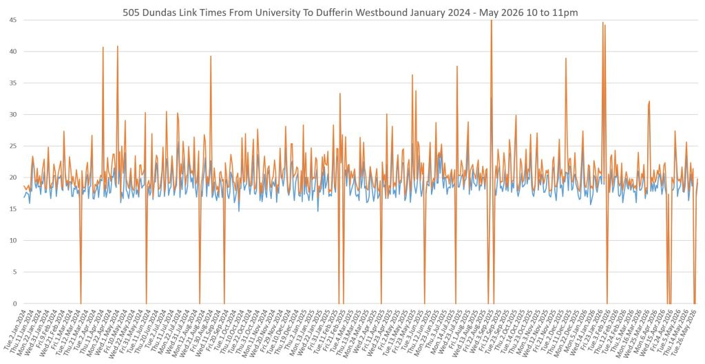
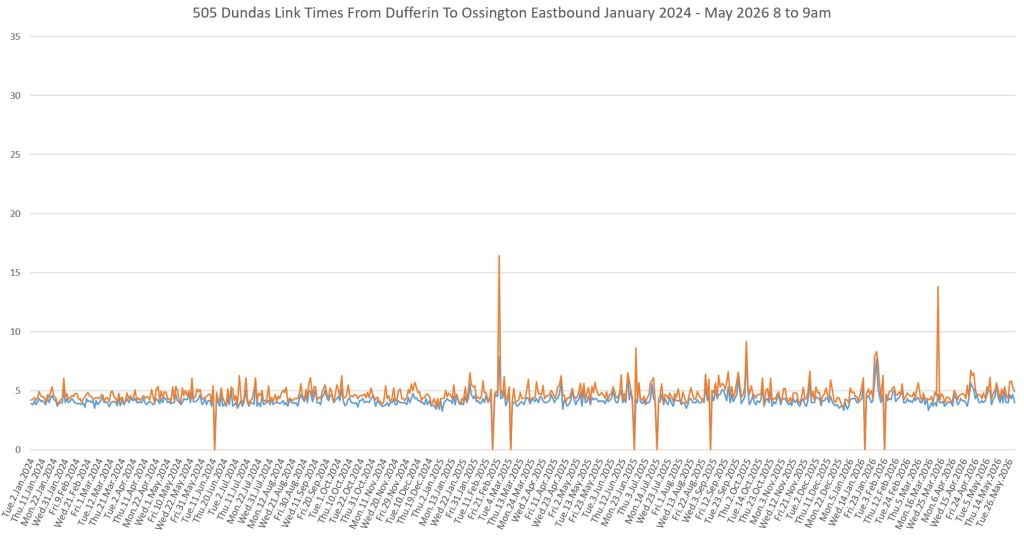
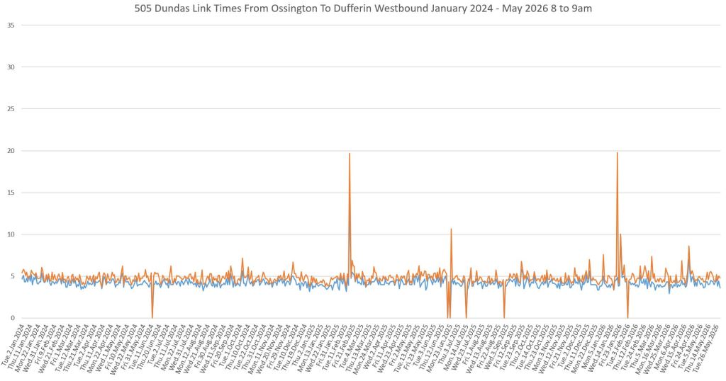
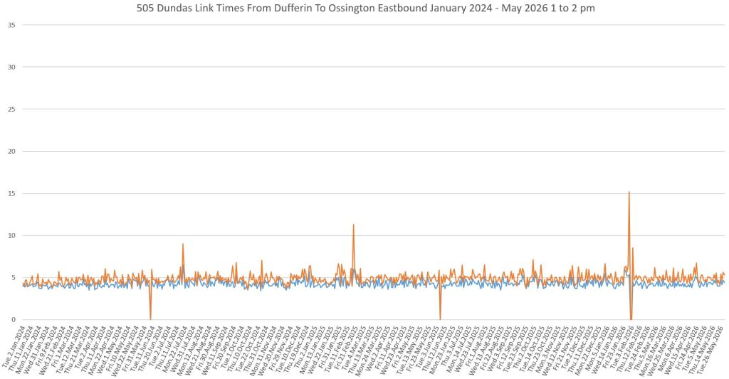
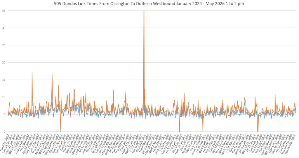
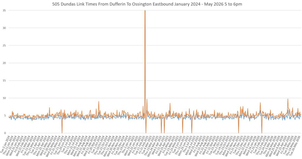
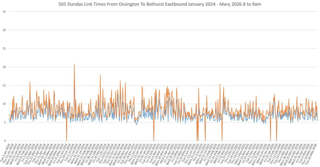
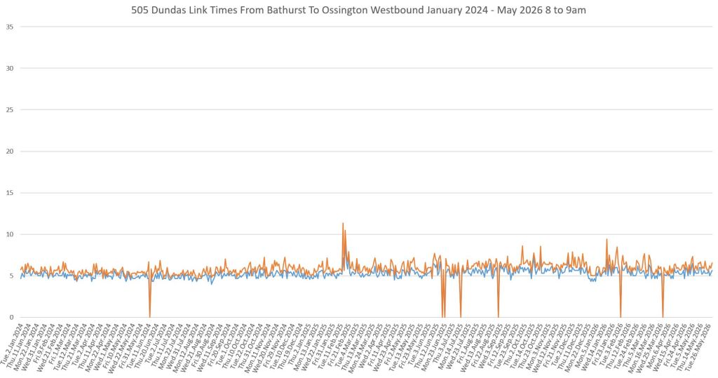
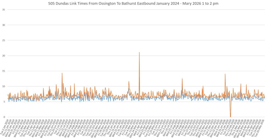
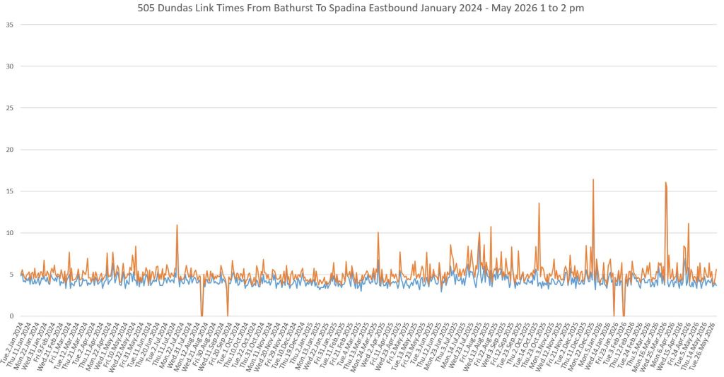
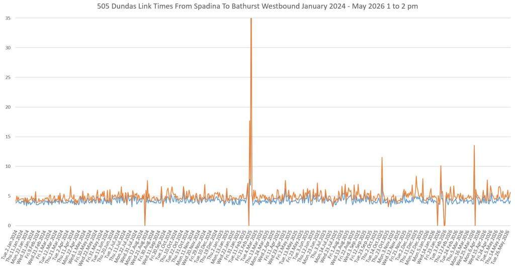
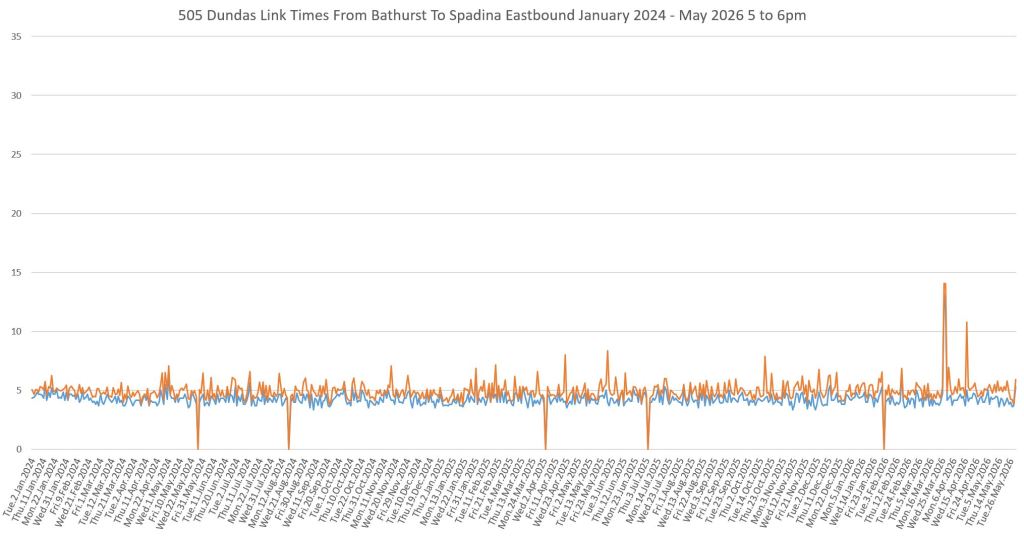
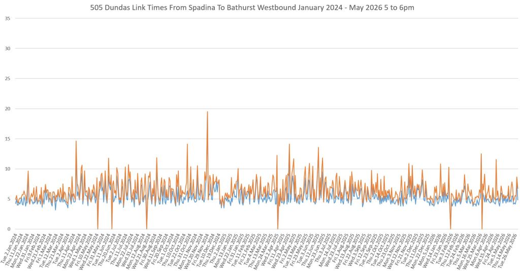
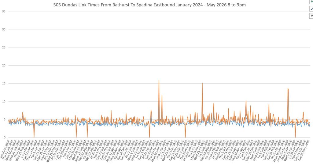
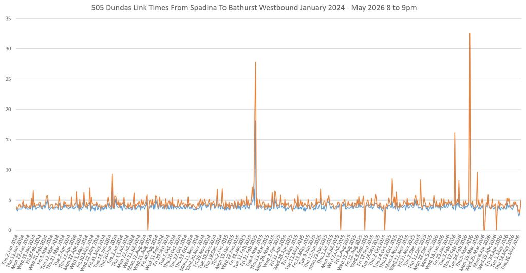
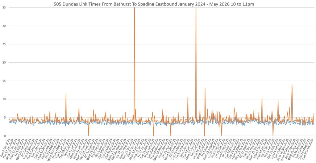
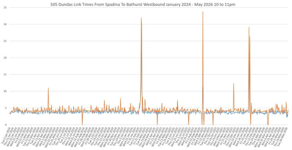
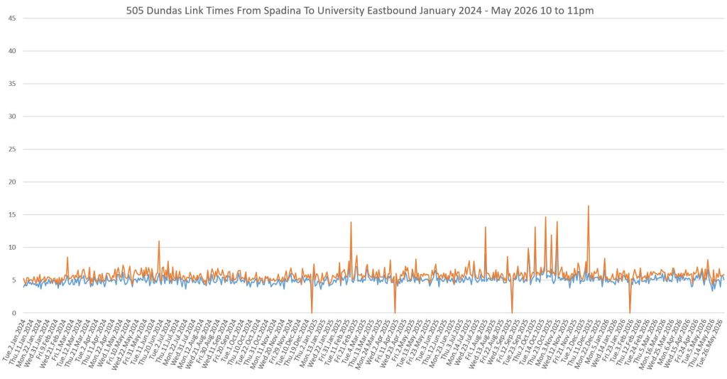
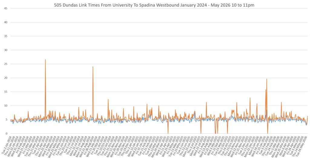
Updated June 22, 2026: Note that in the travel time charts, I omitted the legend in error. The blue lines are median values, and the orange lines are the 85th percentiles.
In these charts eastbound data are shown on the left, westbound on the right. Each row shows data from one hour illustrating the AM peak, midday, PM peak, early and late evening.
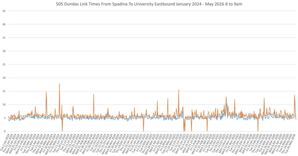
In the AM peak, travel times bounce around much more in the peak direction, eastbound, than westbound. Note the “heartbeat” spikes in the eastbound values. I will return to these later.
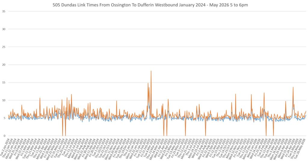
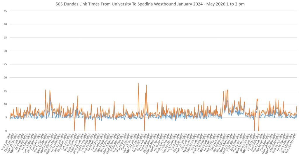
By midday, the westbound travel times are beginning to show more variation, and the full peak direction effect is evident in the PM peak westbound. There is some improvement in recent months with less variation in 2026 than in 2025.
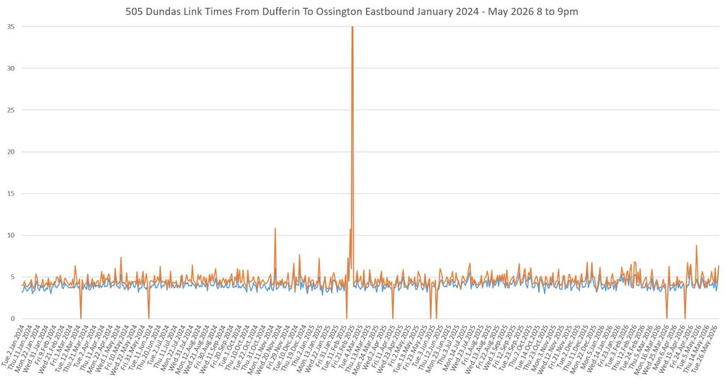
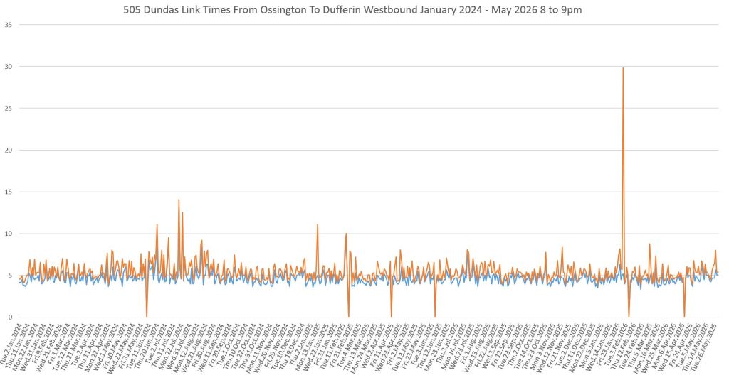
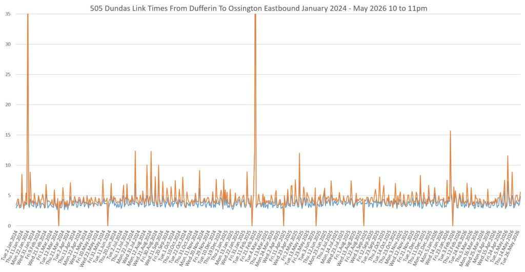
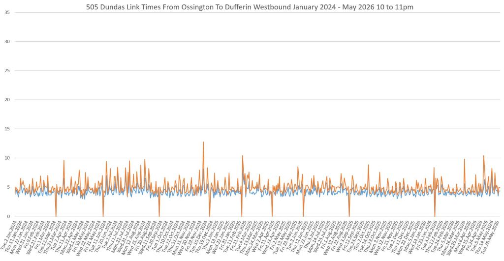
Evening travel times are consistent, but show a “heartbeat” pattern especially eastbound. The source of these peaks is not “downtown” but on Dundas west of Bathurst. (Charts detailing individual route segments are later in the article.)

Day of the Week Breakdowns
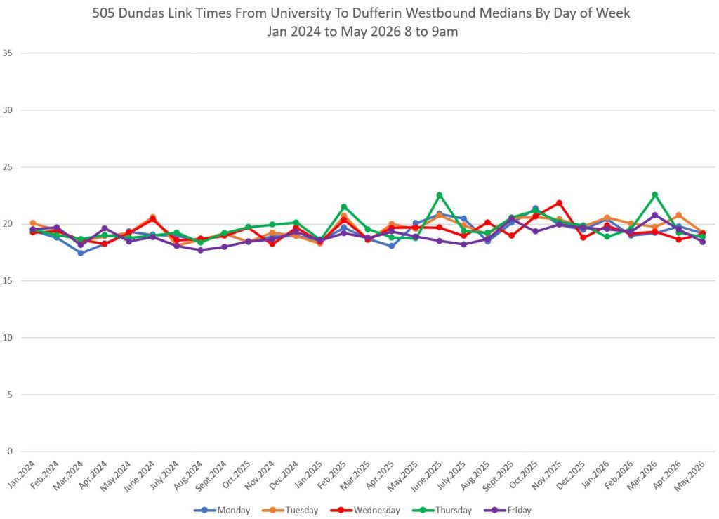
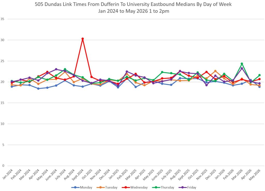
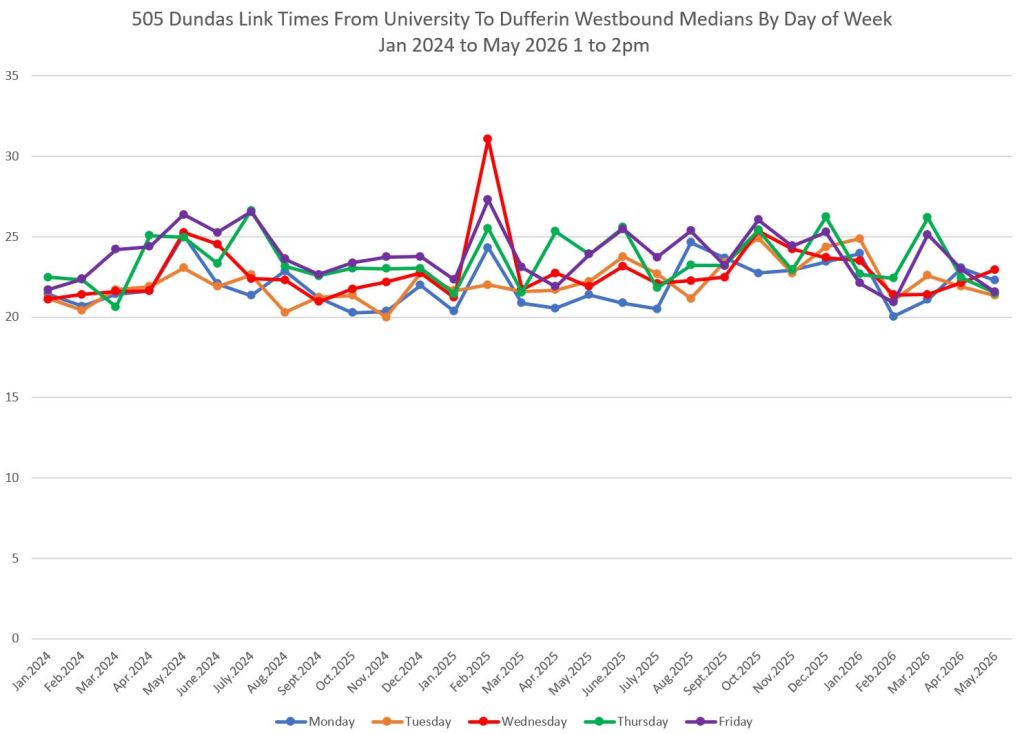
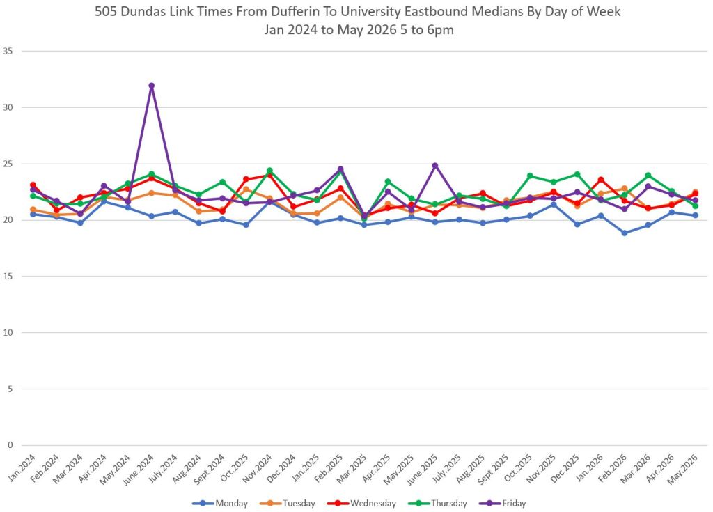
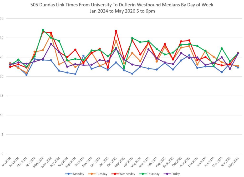
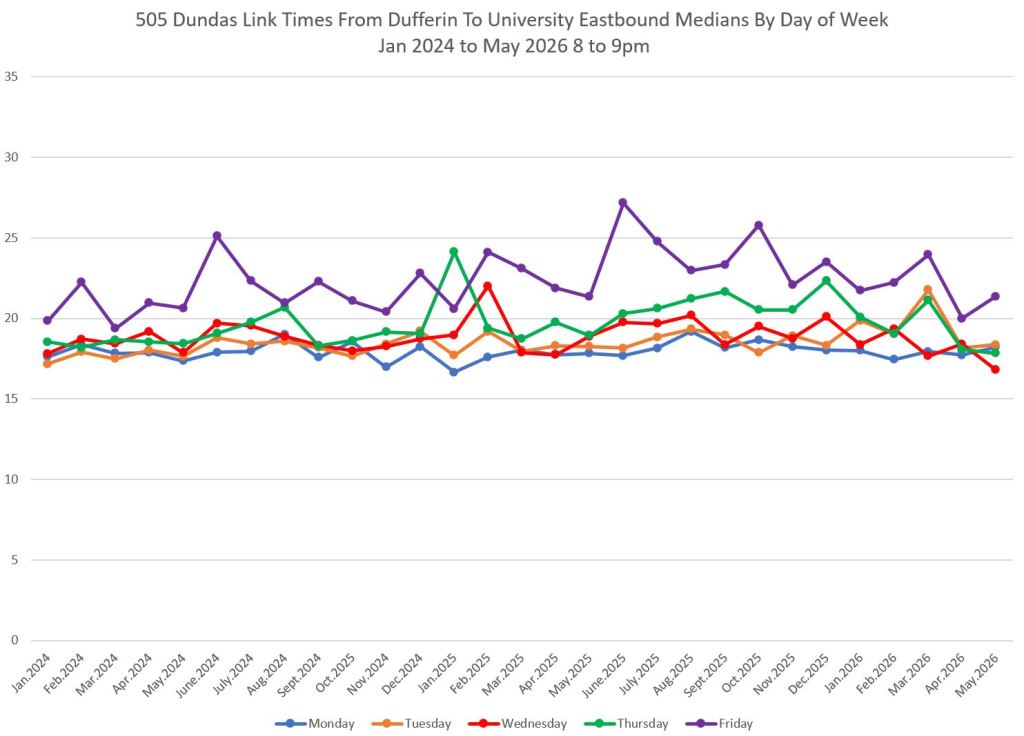
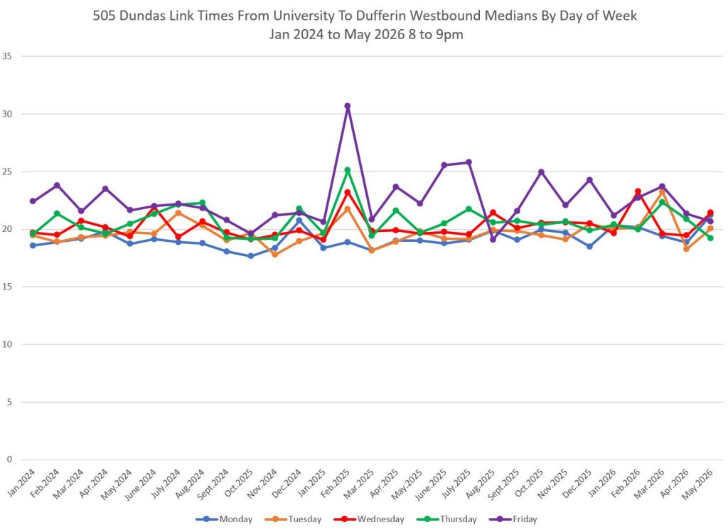
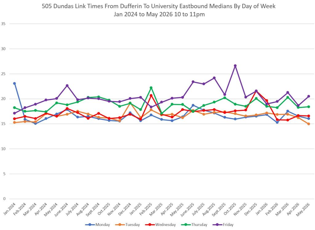
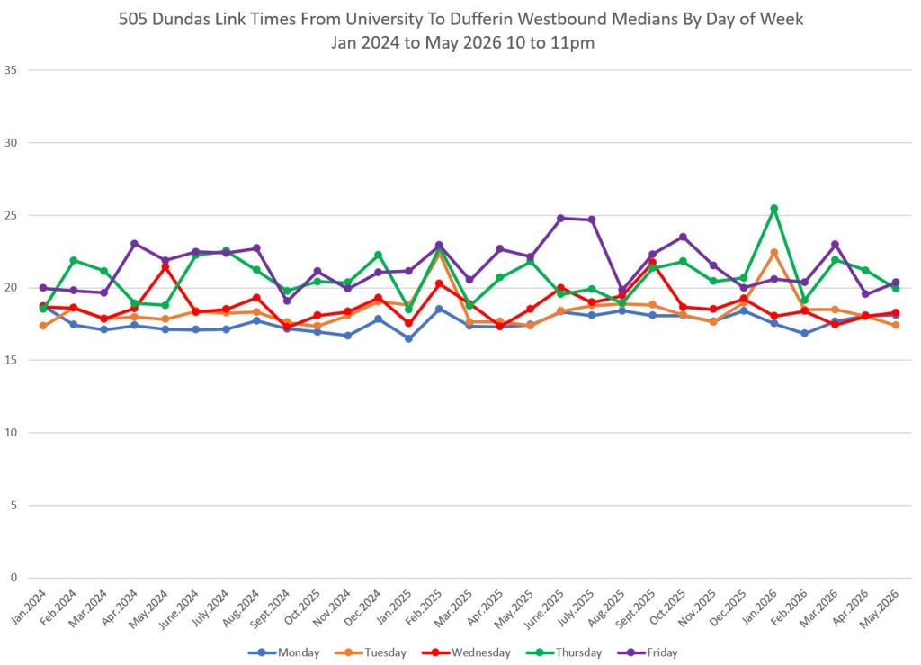
The charts below show the average of median travel times for each month by day of the week.
There is a marked difference in AM peak travel times eastbound and westbound. While the westbound are tightly clustered with similar values for each weekday, the eastbound data show higher values for midweek days, notably Tuesday and Wednesday (orange and red) while Friday (purple) is consistently low.
The pattern shifts by midday with Thursday and Friday (green and purple) eastbound values rising above the others
In the PM peak, there are small differences eastbound with Monday sitting below the other days, but westbound the values are more spread out with Wednesday and Thursday (red and green) sitting at the top.
In the evening, Thursdays (green) and particularly Fridays sit above values earlier in the week.
These charts illustrate how day-to-day scheduling and operations can be challenged by local effects on routes that are predictable, but not every day.
Travel Times Dufferin to Ossington
Travel times over the segment from Dufferin to Ossington are quite consistent both ways. There is some rise in times and variability in mid 2024 westbound but this does not last. The “heartbeat” in late evening travel times starts here and continues into the next segment.
Travel Times Ossington to Bathurst
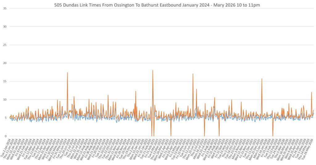
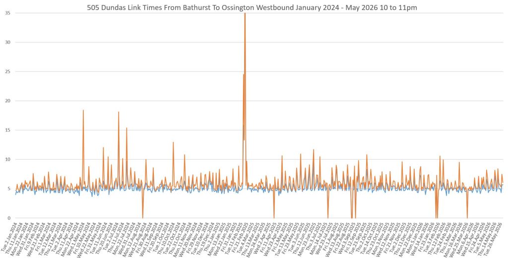
From Ossington to Bathurst, travel times are high and variable in the AM peak eastbound, but not to the same degree westbound in the PM peak. There is a “heartbeat” pattern in the AM peak eastbound corresponding to the greater traffic and ridership levels midweek.
A heartbeat pattern is also in the evening data both ways, although it falls later in the week that the AM peak. (See the detailed dya-of-week charts earlier in the article.)

Travel Times Bathurst to Spadina
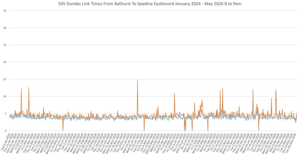
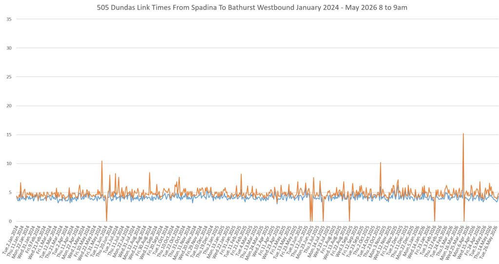
Between Bathurst and Spadina, the period with the most irregular travel times is the PM peak westbound.
Travel Times Spadina to University
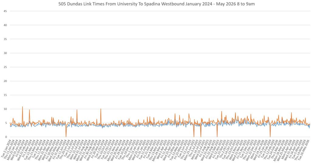
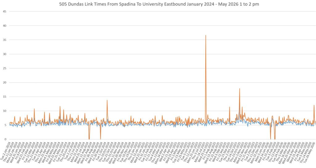
Between Spadina and University, eastbound travel times are consistent in all periods. Westbound times show more variation in the midday and PM peak.
Headways at Dufferin
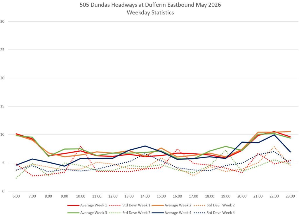
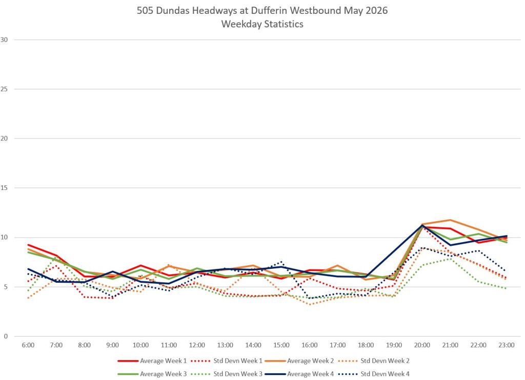
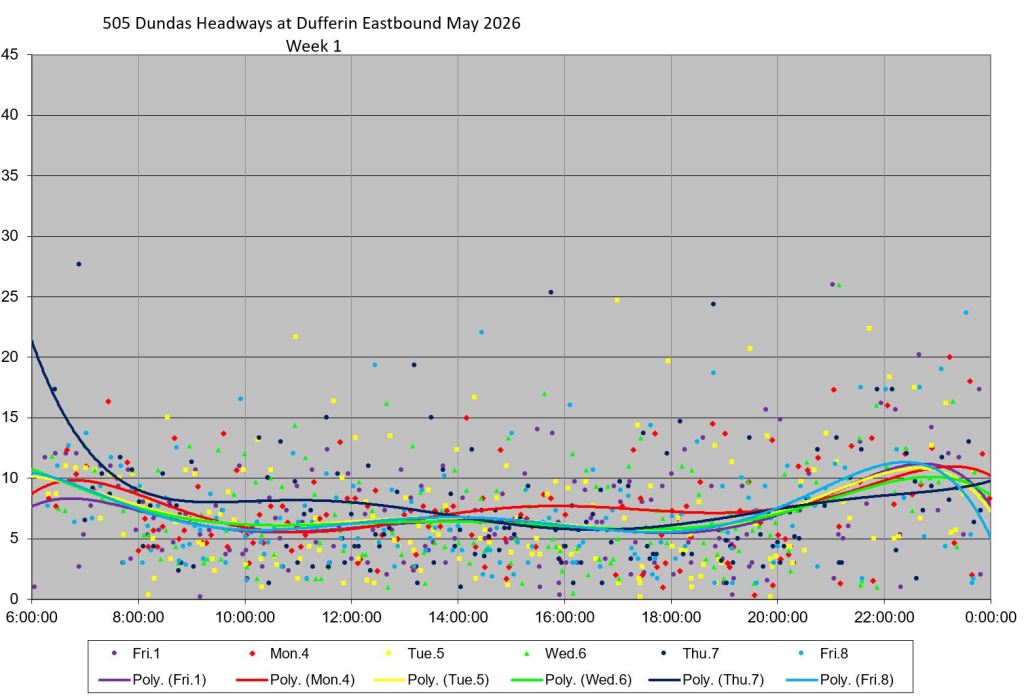
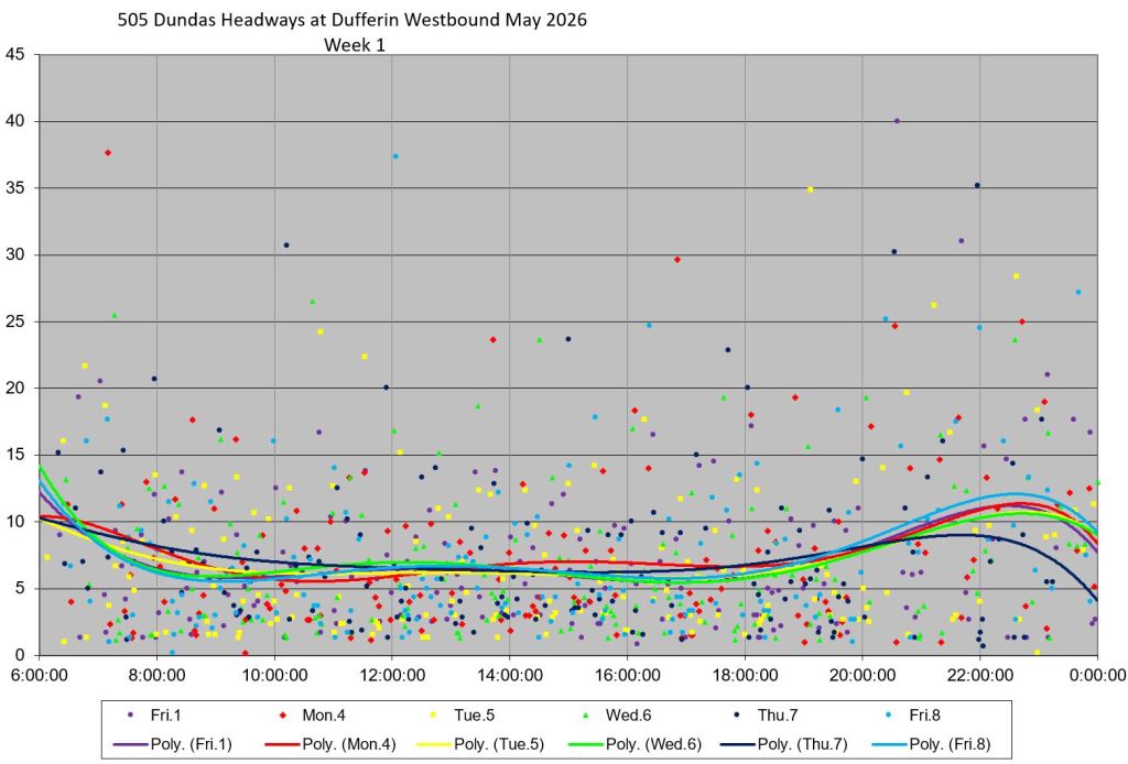
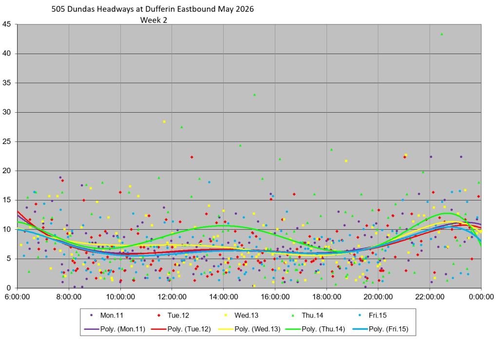
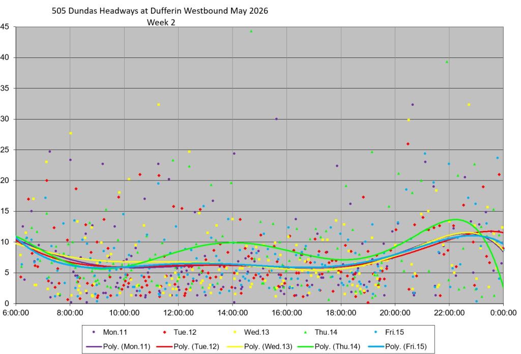
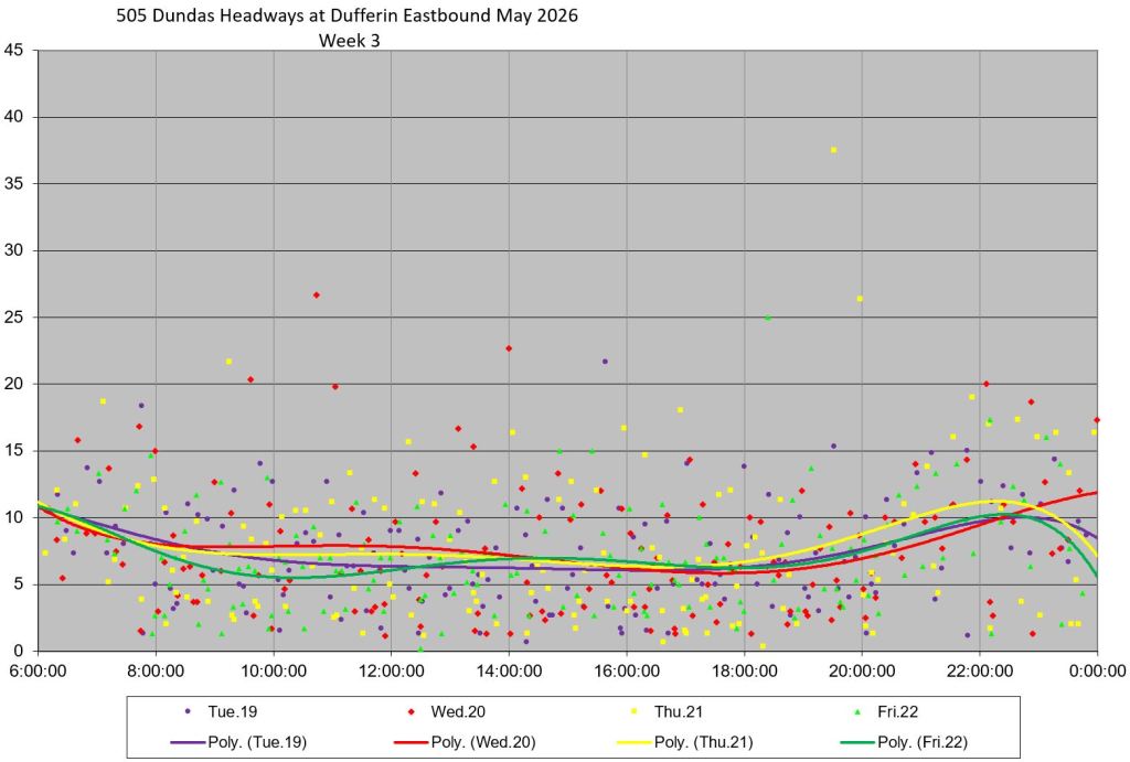
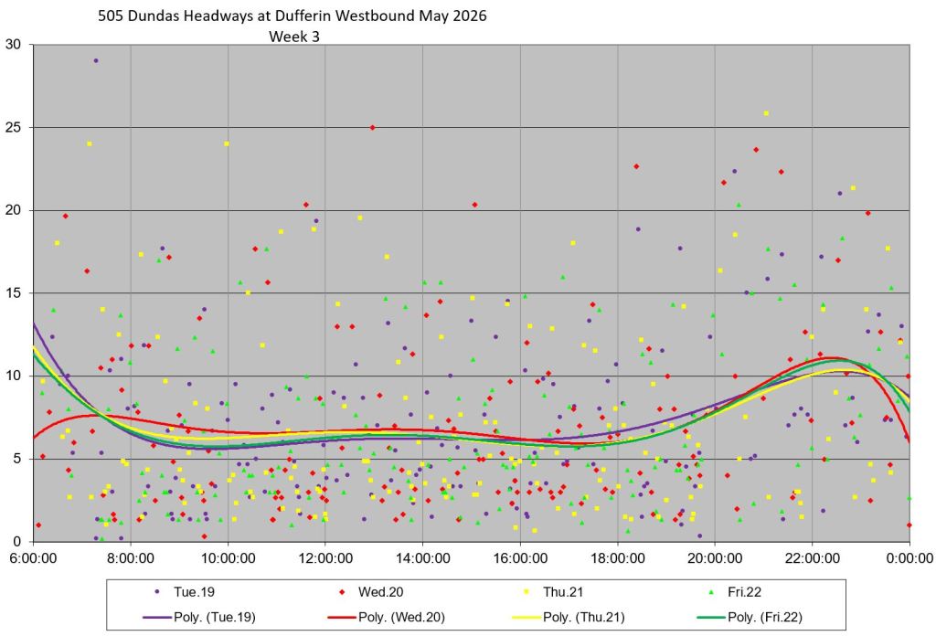
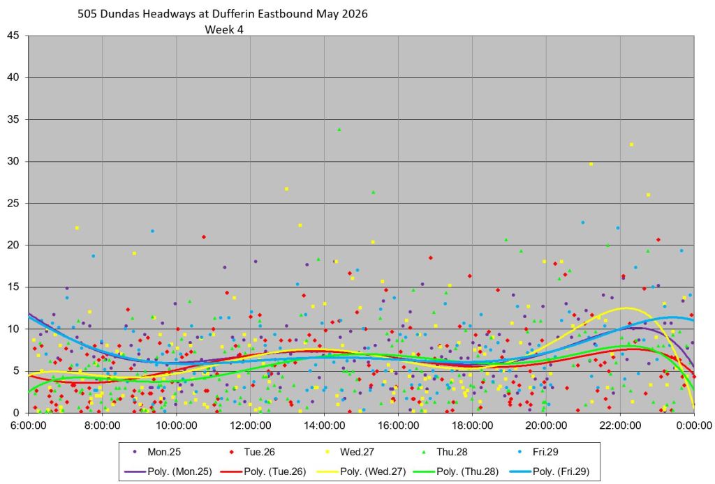
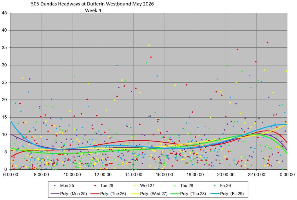
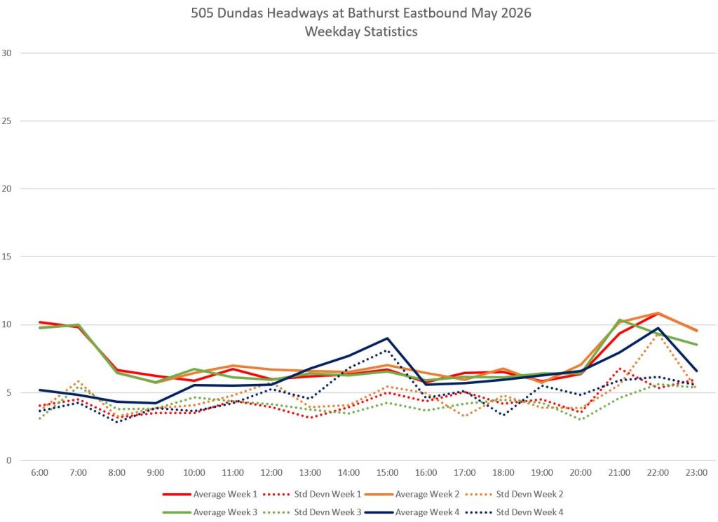
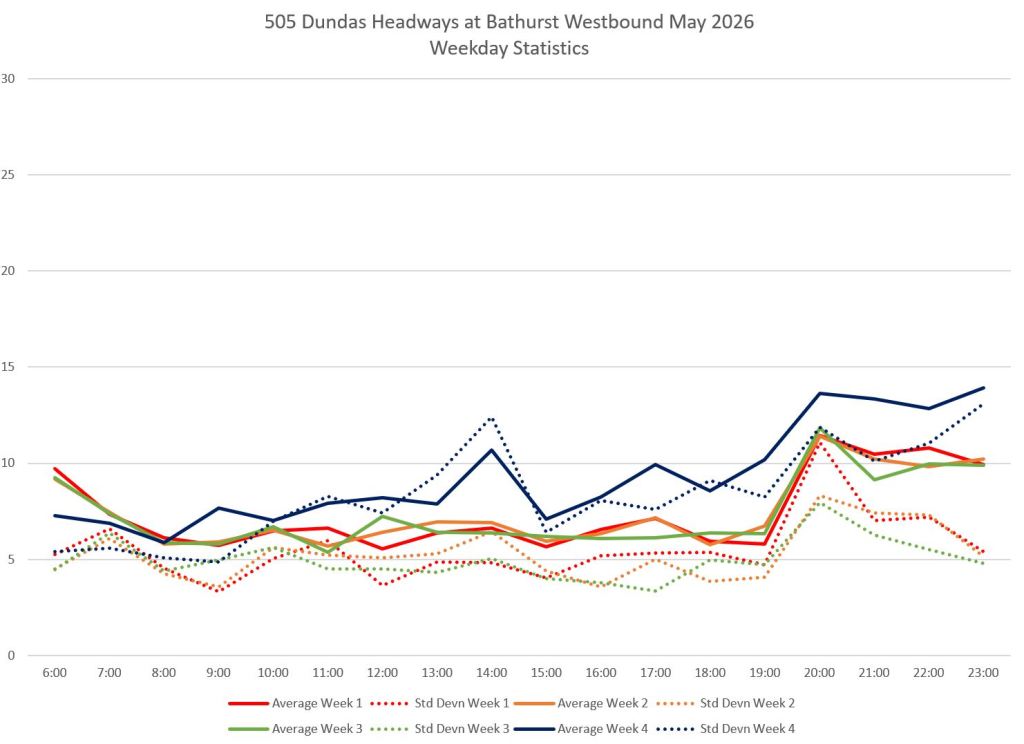
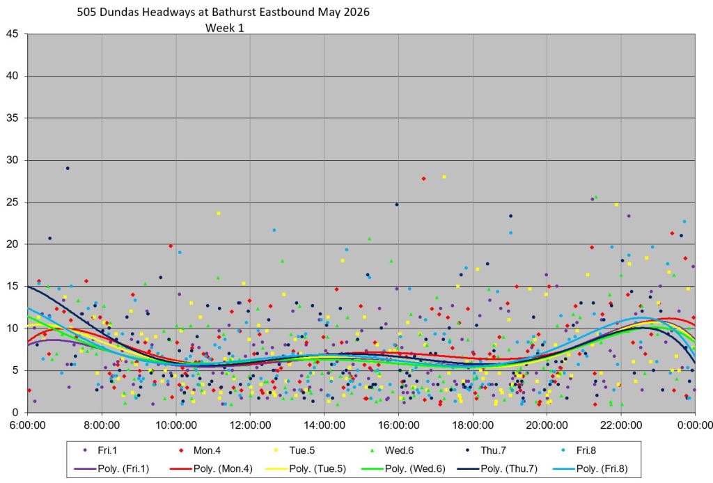
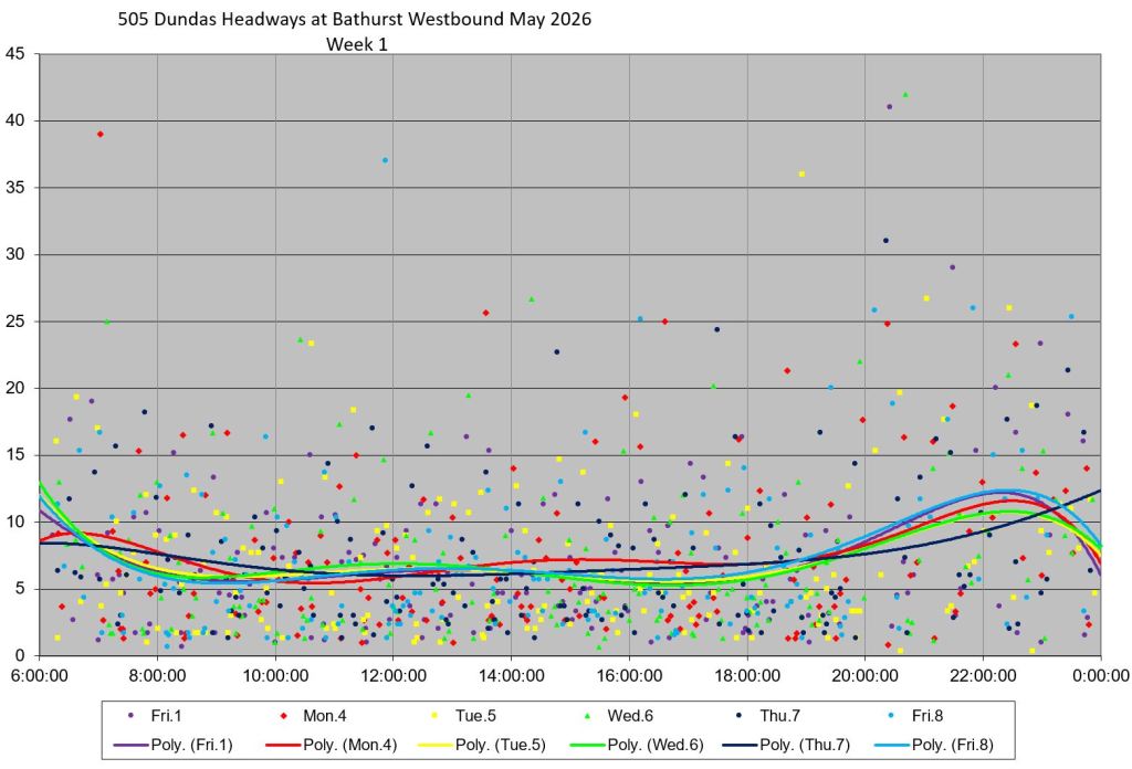
In these charts, the first pair show the overall statistics by week for the headways, Although the average values (solid lines) are not far from the 6-minute service design, the standard deviations (dotted, a measure of scatter in values) are very close to the averages indicating a wide range of actual headways. This is reflected in the following charts showing week-by-week headway data broken down by day. The trend lines lie generally along the scheduled headway, but the individual headways are scattered over a wide range with several over 20 minutes.
Generally speaking, the westbound values are scattered over a wide range showing the cumulative effect of the trip west from Broadview Station. Eastbound cars originated at Dundas West, although even this is comparatively close by. Headways are already scattered with many points close to zero (bunching).
Headways at Bathurst
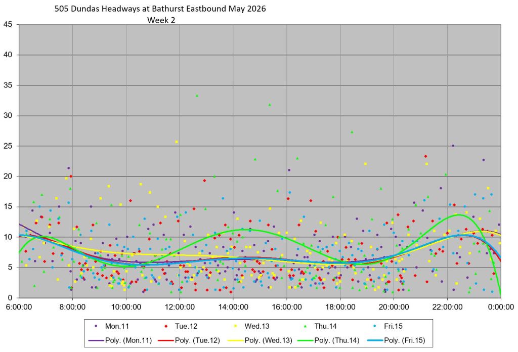
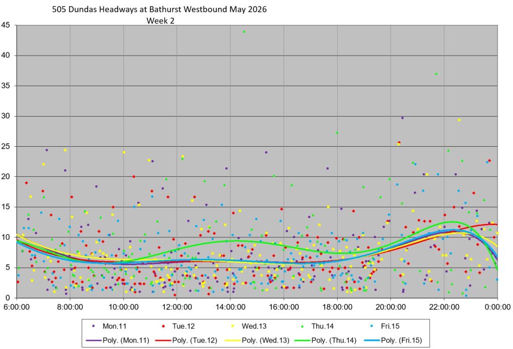
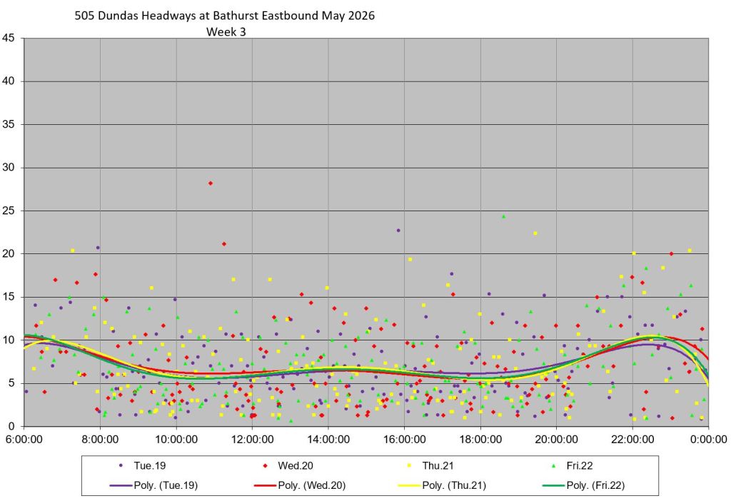
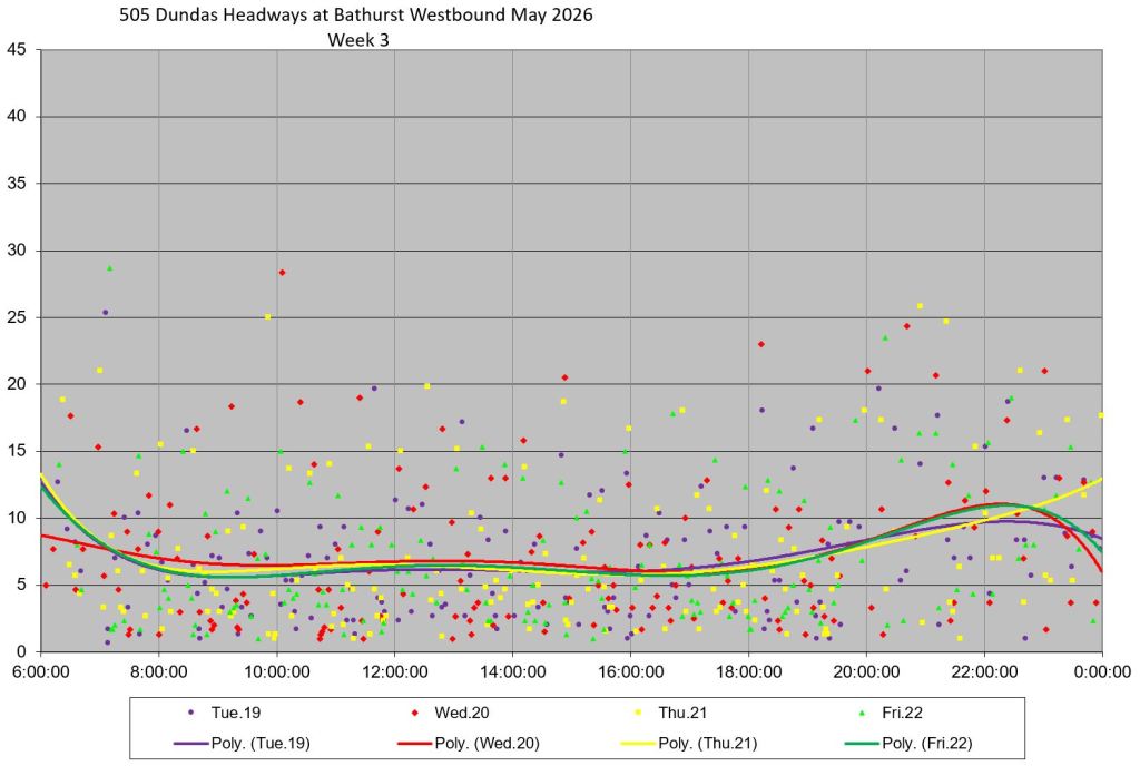
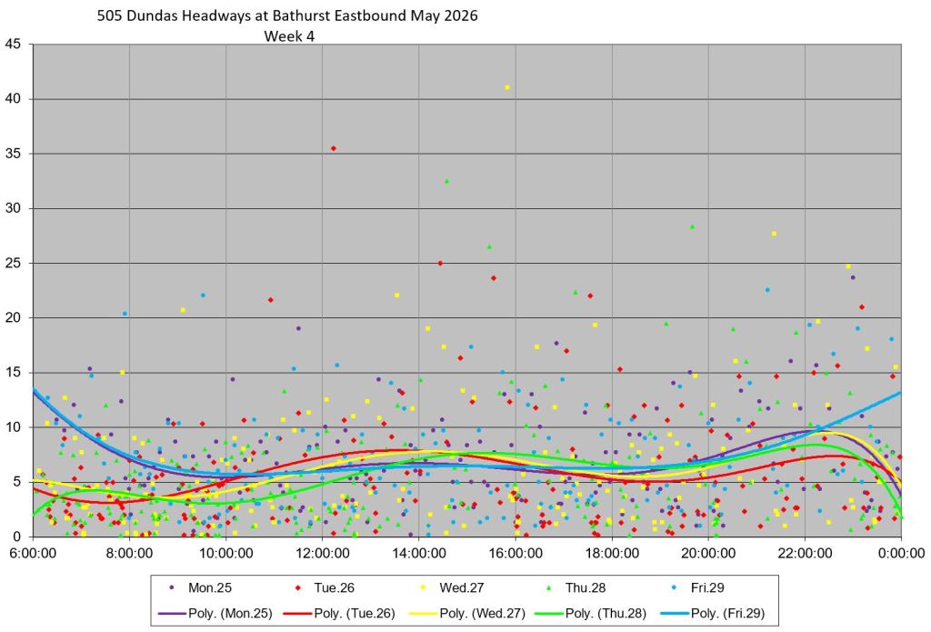
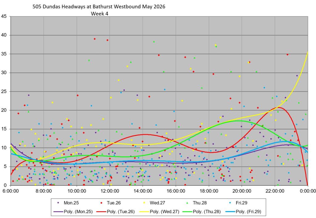
At Bathurst, the eastbound headways reflect the state of service seen above at Dufferin. Although the trend lines for each day lie generally near the 6-minute scheduled service, the individual headways are scattered mainly from 1-15 minutes with some outliers even higher. Westbound service shows greater scatter than eastbound.
Week 4 service was disrupted by a diversion and bus replacement between Bathurst and Bay. This shows up in the westbound headways at Bathurst.
Headways at University
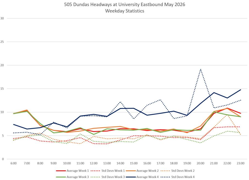
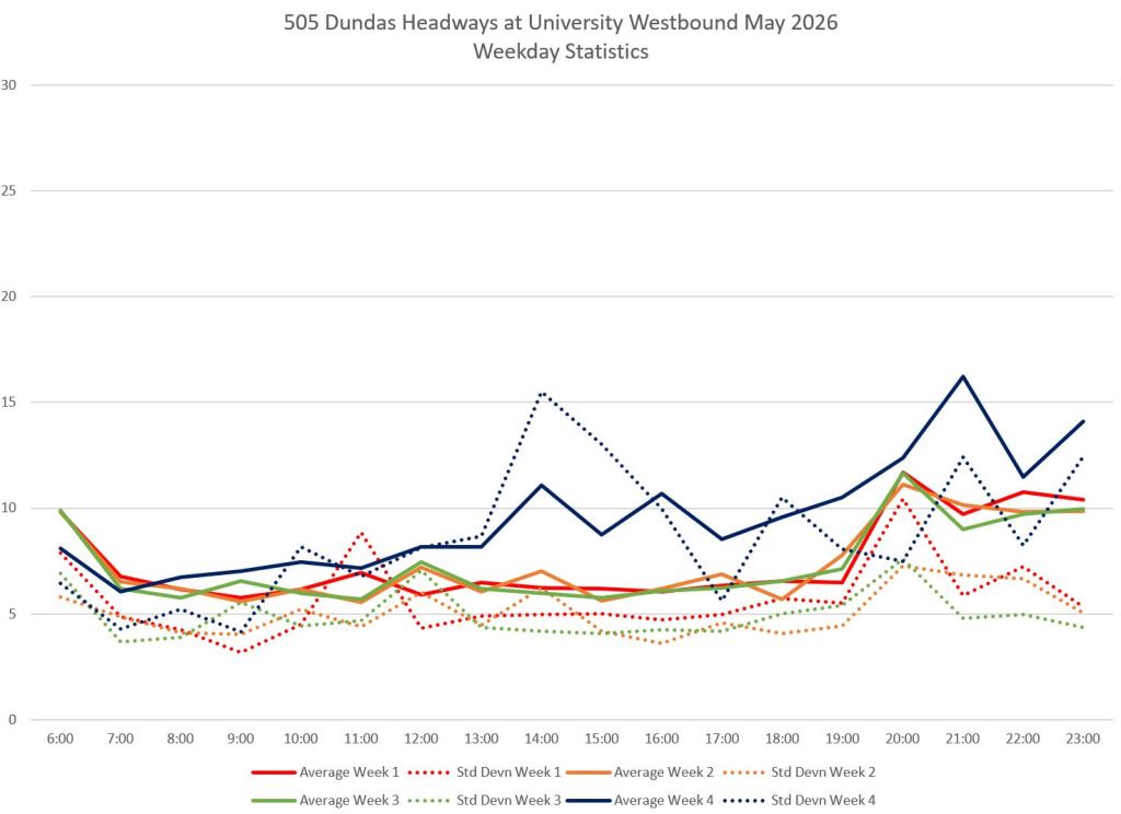
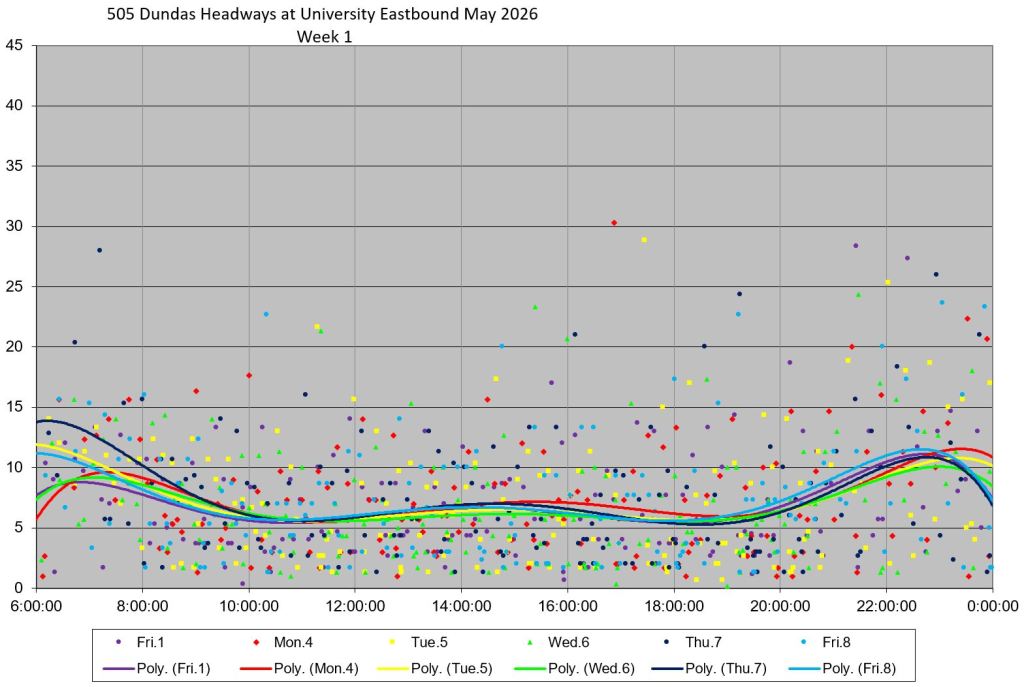
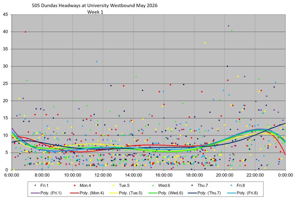
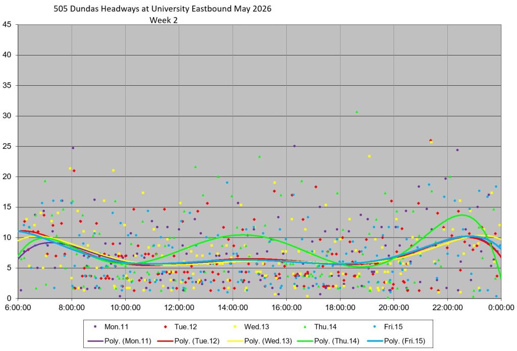
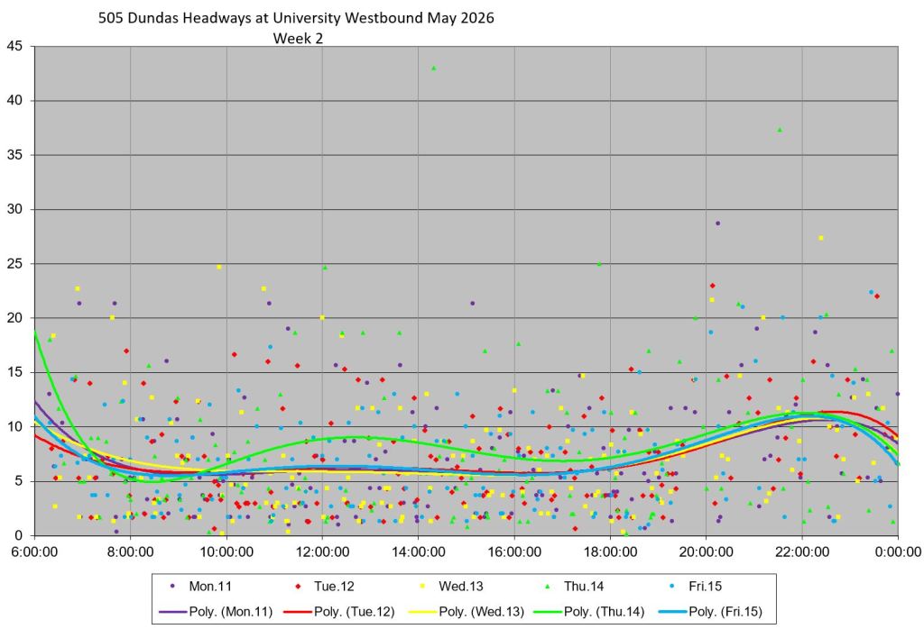
Headways eastbound at University are slightly less scattered than westbound in weeks 1-3 as shown by the lower standard deviation values (left chart, top row below). Week 4 saw Dundas cars diverted to College Street, and the headways for University Avenue represent the replacement bus service to the extent that these vehicles were actually tracked as part of the 505 service.
 Steve Munro
Eastbound at the Don bridge, there are often queues of cars and streetcars, as there is only one lane which is used by through traffic as well as traffic turning left to get on the DVP. This can be a major, but also random, source of delays. Sometimes there’s nothing, sometimes the wait can be a few minutes. It’s luck of the draw.
Unfortunately this is not easily solved, unless you i) relocate streetcar tracks like at College and Maple Leaf Gardens; ii) put in a dedicated left turn lane with signals, to the right of the streetcar tracks; or iii) prohibit left turns.
The last is conceptually easiest but hardest for transportation planners to get their head around.
Steve: Shifting the tracks is likely impossible as I suspect that the bridge is built with extra support for streetcars only under the centre lanes.
As for prohibiting left turns, this is an on-ramp to the DVP. Closing it would likely divert traffic south to the corresponding turn/ramp eastbound on Queen.
LikeLike
What do we know about motorist compliance with the new regulations?
Steve: Given that they are the usual sort of parking and turn restrictions, they are likely reasonably well obeyed. If you review the list, the changes affect only part of the day and in the counterpeak direction.
LikeLike
Toronto’s streetcar and brand new LRT network is the envy of the world providing world class rapid transit to millions everyday. Toronto’s streetcar/LRT system is the most reliable mode of transit invented thus far and up north, York Region is eyeing converting its slow BRT system into a rapid LRT system like Toronto.
Steve: Although I would like to believe it, I find both of these claims hard to swallow. Toronto hobbles its surface rail lines with poor operating practices and “priority” that is more about cars than streetcars. As for York Region, they might have a network of bus lanes but service is nowhere near the level conversion to LRT is likely especially with an anti-streetcar government at the province. The subway jocks would extend line 1 to Hudson’s Bay before they would accept a streetcar on Yonge Street.
LikeLiked by 1 person
Are 505 (and 504) streetcars entering and egressing Dundas West Station and Broadview Station still slow? Still no transit signals nor yield to streetcars at those stations because that would take priority away from the single-occupant automobile? Have they at least painted the streetcar tracks red on Edna Avenue and Erindale Avenue (red cobblestones would be better)?
Steve: At Dundas West, the main problem is traffic backed up from Bloor where a combination of a long east-west green and left turning traffic (including buses) limits through movement southbound. At Broadview Station, the stops on Erindale and on Broadview southbound at Danforth have been removed. This is a personal inconvenience for me, but it does mean that streetcars don’t miss a cycle serving the stop at Danforth. The greater problem is the clouds of buses thanks to the diversion of 25/925 Don Mills service from Pape Station, and on street loading by the 8 Broadview and 62 Mortimer. Northbound traffic often backs up blocking the exit from Erindale, and streetcars sometimes have to push their way across. The idea of adding a signal here has been rejected previously because of the close spacing to signals at Danforth and at Pretoria.
LikeLike
Ha! The only things Toronto drivers pay less attention to than No Parking/No Stopping/No Standing zones, are STOP signs and speed limits.
LikeLike