
Updated December 2, 2018 at 8:00 am: A sixth set of charts has been added covering the last two full weeks of September 2017. The intent is to show fall conditions before the pilot, but also before construction on King (at least some of which was to set up the pilot itself) slowed King cars in the early November 2017 data already published here.
With a year’s worth of the King Street Pilot now behind us, attention turns to two basic questions: should King Street remain as it is with a degree of priority for transit, cyclists and pedestrians; and should this scheme be extended to other major streets, notably Queen Street.
In previous articles I have reviewed the behaviour of the King and Queen routes:
- King Street Update: October 2018 (Part I) : Travel times and service capacity
- King Street Update: October 2018 (Part II) : Evolution of scheduled and actual service
- 501 Queen and the Effect of the King Street Pilot : Effects of the pilot on Queen Street travel times, and comparisons of travel times on King and Queen Streets
This article provides a detailed look at average weekday speeds along the streets during six separate periods, and with hourly breakdowns from 6 am to 1 am.
- January 16-27, 2017: Winter operations downtown deal with less traffic, especially on Queen Street. This is a “before” snapshot of the two streets.
- September 18-29, 2017: Fall conditions after TIFF and before the beginning of construction at Queen & McCaul.
- November 1-10, 2017: Just before the implementation of the pilot.
- January 15-26, 2018: Winter operations with the pilot in place.
- July 16-27, 2018: Summer conditions for the pilot. (2017 was a construction year on Queen and a direct comparison to 2018 is not available.)
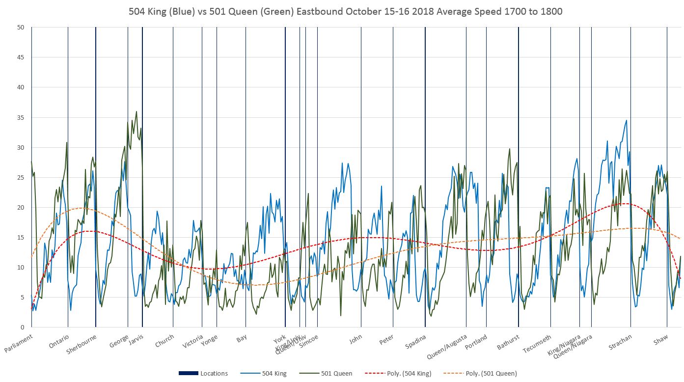
- October 15-26, 2018: Current fall conditions.
This gives a view of “normal” conditions, but does not capture all of the seasonal and special event variations, many of which are evident in the data in previous articles. The periods have been chosen to avoid skewing the numbers with special events such as TIFF, vacation periods and construction.
A Caveat About “Average Speed”
The values show in these charts are derived from TTC vehicle tracking data. This originates in GPS format, and after cleaning up the “rogue” points that are off route due to GPS errors, what is left is mapped onto a version of the route broken into 10m segments. The speed of a vehicle at each segment is determined by the “before” and “after” locations of adjacent GPS observations and the time difference (usually 20 seconds) between them.
These values give the average speed within each segment of all vehicles whose GPS data placed them there. This is not the same as the average speed over the entire pilot area on any given trip. What the numbers show is the locations where vehicles tend to be making good time between stops, the places where they are bogged down, and the places where they stop. Even at stops, the average is never zero because it includes observations where vehicles are just stopping or just starting up within a segment, not to mention variations in stopping location and cases where vehicles do not stop at all.
The Effect on Riders
Vehicle speeds on Queen are often comparable to those on King, but Queen is notorious for less frequent, unreliable and crowded service. Riders are very sensitive to waiting times at stops, and this is compounded if they cannot board the first vehicle to appear, let alone if they walk some distance without a streetcar ever passing them.
With the King Street Pilot there has been a reduction in the variability in travel times which has led to less irregular service. Scheduled service comes more often and the line’s capacity has been improved with new streetcars. Speed alone is not the only measure of a service improvement.
It is vital that debates about the effectiveness of changes to King are debated not just on speed but also on reliability and capacity for demand. The early focus on speed changes which were, in some cases, unimpressive, opened the field to critics who argued that there was a great upheaval for little benefit. It is the combination of more reliable travel time, increased speed, reliability and capacity that has affected the riding experience and drawn more people to use this route. Any move to expand either the scope on King or to another street must take all of these factors into account.
Reading the Charts
Each chart contains data for one hour’s operation in one direction. Here is a sample from the PM peak westbound in October 2018:
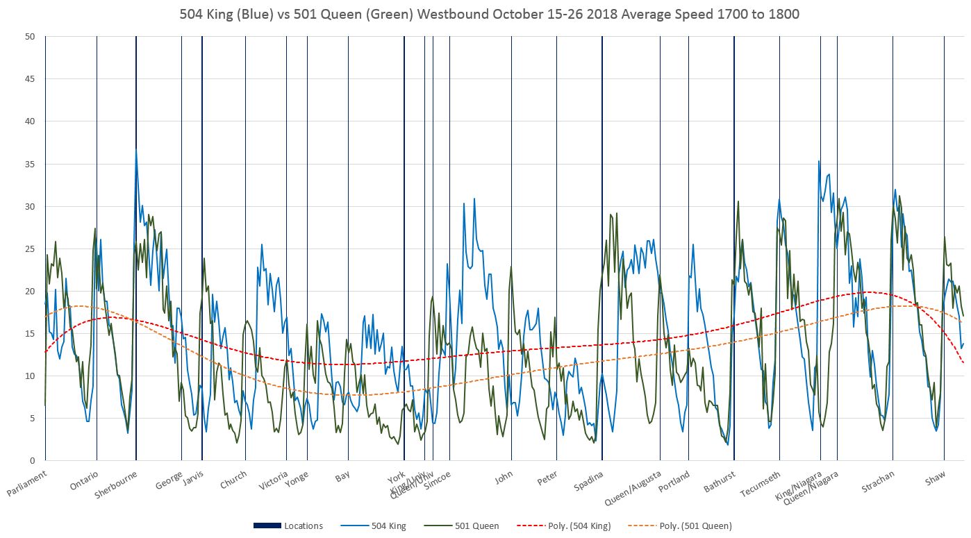
The blue line shows data for King while the green line shows Queen data. Trend lines are interpolated through the data for King (red) and Queen (yellow).
The limits of the chart are east to Parliament and west to Shaw, both beyond the Jarvis-Bathurst pilot, for a few reasons:
- The wider scope shows conditions on the approaches to the pilot area.
- The nature of the trend line calculation in Excel can cause misleading behaviour in the lines as Excel tries to project beyond the charts using values near the edges. Having a “buffer” area on either side of the pilot ensures that the trend lines do not include this problem through the Jarvis-Bathurst section.
Queen and King run parallel to each other with most north-south streets at the same location on both. This allows data from the two routes to be lined up on a single chart. A few notes about special cases:
- Sherbourne Street is used as the reference point for aligning the data. The distance from Sherbourne to Bathurst is the same on each street.
- Ontario Street is slightly offset on Queen relative to King.
- Parliament Street is slightly further east of Sherbourne on King (measured as travel distance) than on Queen due to the shift in King’s direction just west of Parliament at Berkeley.
- Victoria Street has a small jog at Adelaide. The line on the charts reflects its location on Queen which has a transit stop and traffic signal.
- The stop and traffic signal at Queen and Augusta have no equivalent on King.
- Niagara Street curves eastward between Queen and King, and so the crossing points are different on the two streets.
Westbound charts as above are read from left to right. Eastbound charts are in the same format and should be read from right to left.
Comments on the details of these charts are included later in the article.
