Readers with long memories might recall the early days of plans for a new streetcar order including discussions about how large a vehicle should be purchased. A major concern at the time was the possibility that the TTC would change schedules and run less frequent service with the larger cars just as they had when the articulated version of the CLRV (the previous generation of cars) arrived in the late 1980s.
That concern was softened by a TTC claim that service would actually improve. Peak periods would see slightly less frequent service, but a net increase in capacity, while off-peak periods would see little change in frequency effectively doubling the capacity of service. At the time, crowding was a big issue and this persisted right up to the pandemic in 2020, by which time all of the old cars had been retired. The management proposal was approved in July 2013.
As the CLRV/ALRV fleet aged, there were problems with reliability of older cars and the need to operate buses on some lines thanks to a shortage of working vehicles. Some repairs were done at considerable cost, but these were more cosmetic than a true life extension.
Moving forward to 2026, there has been a lot of talk of restoring pre-pandemic service levels. TTC fudges the numbers on this in many cases citing vehicle hours operated, not actual service frequencies which have been degraded by longer travel times.
(For example, if a round trip, including terminal layovers, takes two hours or 120 minutes, then 20 cars will provide a 6-minute service. If the round trip gets longer but no cars are added, the service is less frequent, but the number of vehicle hours stays the same. From a rider’s point of view, service is worse, but from a budget outlook, there is no change. This is at the heart of the discrepancy between TTC service claims and rider experience.)
After years of changing service levels and demand, the TTC’s Five Year Plan foresees a return to six minute headways, at most, as a new standard for daytime service. This has been rolled out on some routes over the past year, but not all.
- Already at 6 minutes or better: 504 King, 510 Spadina
- Improved to 6 minutes: 512 St. Clair (Sept/25), 511 Bathurst (Nov/25), 505 Dundas (Nov/25)
- Pending, but with no committed date: 501 Queen, 503 Kingston Road, 506 Carlton, 507 Long Branch.
The Five Year Plan (at p. 4) includes provision for extra spending in 2027 and 2028, but this is not tied to specific routes. There is nothing in the Plan for 2026.
A related issue is the size of the streetcar fleet. Leading up to 2020, the issue was how many cars were actually available, and some service cuts flowed directly from this. With the recent delivery of 60 additional cars, fleet availability should not be an issue although service can still be limited by a lack of operators. The TTC currently schedules 163 cars at peak out of a fleet of 264. If services now operating with buses due to construction were also using streetcars (503 Kingston Road and the Broadview branch of 504 King), the peak requirement would rise to 178. Allowing for maintenance spares this would drive the total requirement to 214 leaving 42 surplus for service improvements (allowing for 8 spares).
| February 2026 Schedule PM Peak | Full Streetcar Service | Possible Service | |
|---|---|---|---|
| Peak Requirement | 163 | 178 | 220 |
| Spares at 20% | 33 | 36 | 44 |
| Total Requirement | 196 | 214 | 264 |
| Fleet | 264 | 264 | 264 |
| Surplus | 68 | 50 | 0 |
The problem, of course, is that the TTC barely has budget headroom to operate existing services let alone increases.
In theory, some of the surplus cars will eventually operate the Waterfront East LRT extension, but that service is at least 8 years away even assuming Toronto finds the money to build it. In any event this will not require anywhere near all of the current surplus fleet. Another issue is that the “streetcar network” has not operated with 100% streetcar service for a few decades thanks to various construction projects and vehicle shortages.
There are parallel issues with the bus network, but they are complicated by issues of vehicle reliability and the need for a spare pool to cover the unreliable LRT service primarily on Line 6 Finch West. I will turn to the bus fleet in a separate article.
Back in 2013, the TTC proposed how it would operate with the new streetcar fleet. During peak periods, headways would widen particularly where existing service was very frequent. Notably on 501 Queen, there would only be a slight widening of the time between cars in the AM peak and no change in the PM peak. This reflected the fact that Queen was already running with the 75-foot long ALRVs and needed more capacity.
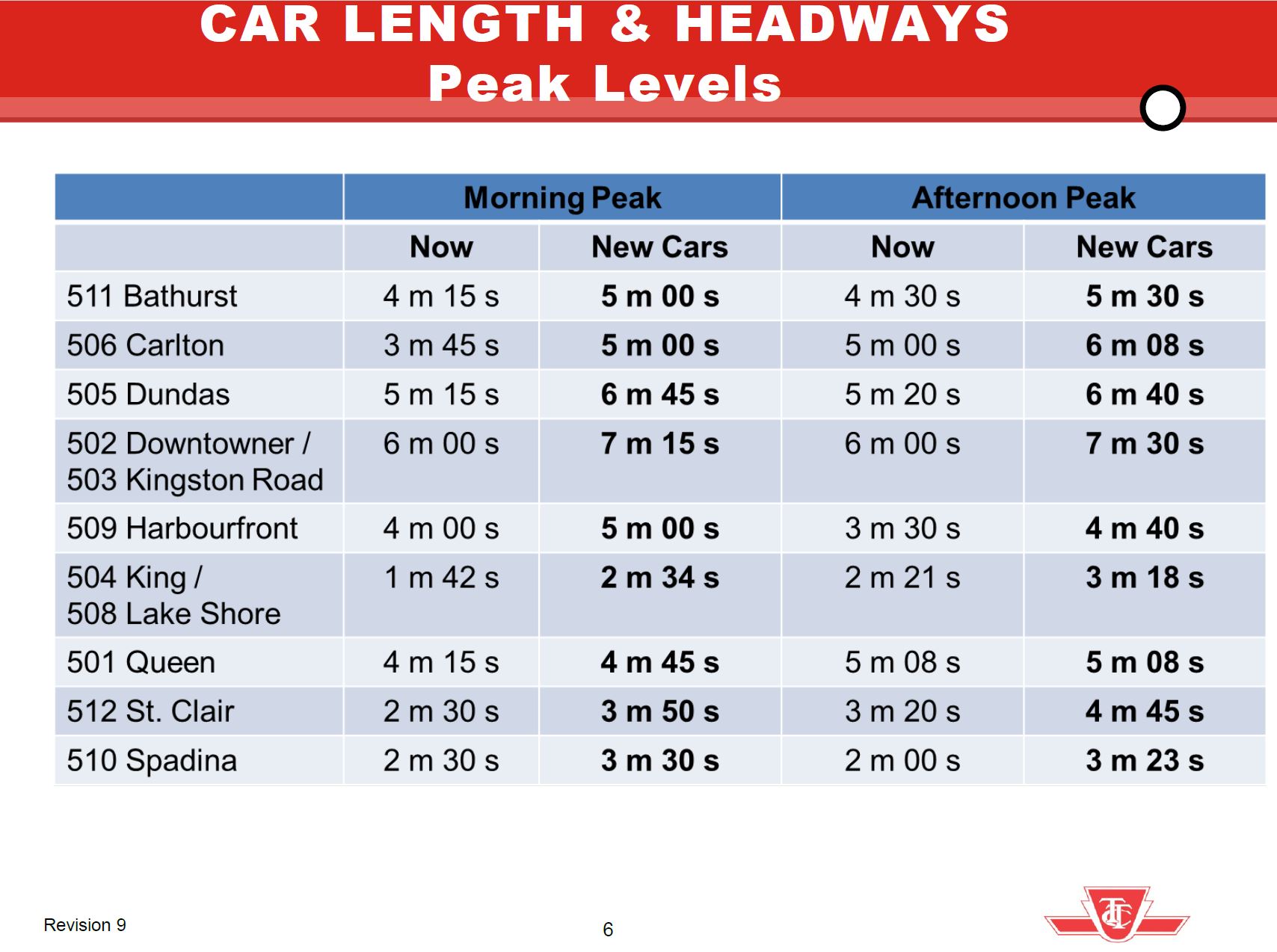
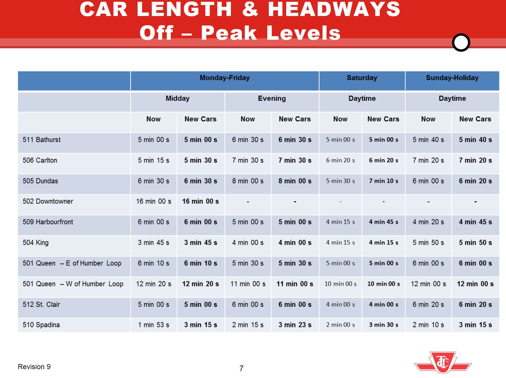
In the off peak, most routes would see no change in service level except for 510 Spadina due to its already frequent service of 50-foot CLRVs that could not be sustained at terminals with the larger new cars.
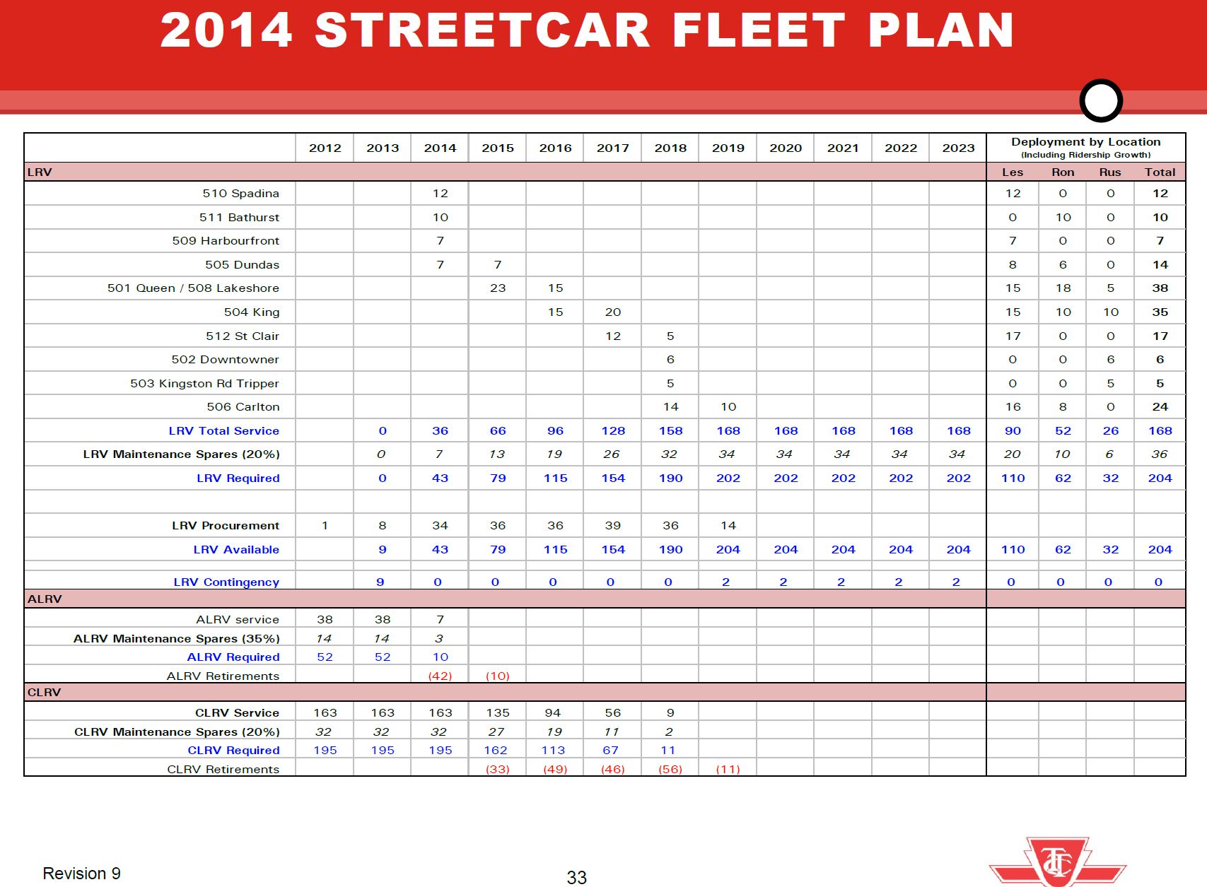
The overall fleet plan showed a buildup to a peak requirement of 168 cars plus 20% spares.
This plan gave a bright future for streetcar service and capacity growth, but things did not work out that way. Service today is generally lower than originally projected for the new fleet, and part of this reduction is due to slower operating speeds and greater provision for terminal recovery time even on routes with reserved lanes.
A related question is the effect that less frequent service has had on ridership. There is a post-pandemic slump on the streetcar system in part due to work-from-home for office jobs and remote learning for post-secondary students. However, even allowing for the pandemic era drop, the problem remains in attracting riders back to transit when streetcars are less frequent and slower, compounded by chronic problems with service reliability. Charts tracking streetcar ridership from 1976 to 2024, the last year published by TTC, are at the end of the article.
These routes are in the part of Toronto where transit riders should be easy to win, but a long decline in service frequency discourages those who have the option to use another mode including private autos, ride hailing or cycling. Service cuts during economic downturns do not magically get reversed as times improve, and ridership that might be wooed back to transit instead faces less reliable service and a political attitude that favours big spending on subway projects, not surface transit.
The remainder of this article looks at each route in detail to see how the actual service changed from the 2014 plan through the 2020s to today comparing:
- The 2014 headways for AM Peak, Midday and PM Peak in the management proposal.
- The proposed headways after routes converted to Flexity streetcars.
- The actual scheduled service in January 2014, January 2020 (just before the pandemic) and February 2026. Driving times are shown separate from terminal recovery times to illustrate how each component has evolved.
Quite notable on many routes is the growth in both scheduled driving and terminal times. Although it is common in the mid-2020s to regard extended travel times and traffic delays as a recent, post-pandemic phenomenon, this pattern started earlier and is evident in 2014:2020 comparisons. Surplus time, it was argued, would prevent short turns, a claim that is demonstrably false as most riders know on a daily basis, but it slows service, wastes resources and forces wider headways.
Continue reading