Subway Fleet Planning(?)

The TTC’s ongoing inability to correctly provide for its fleet requirements gets embarrassing at times.  A big one comes during consideration of capital budgets when there always seem to be brand new projects that appear out of thin air even though they should have been foreseen.

The questions of subway capacity and fleet size are not small change, something to be fixed up with the underspending in a few minor accounts.  If you get it wrong in one direction, nobody can fit on the trains, and the lead time to fix this condemns riders to horrendous service.  If you get it wrong in the other direction, you have a bloated fleet, an investment in trains and yard space that might have gone to more deserving projects, and a padding factor that works against efficiency in maintenance because there’s always another spare train in the yard. 

The TTC’s surrent subway fleet plans do not include cars for the subway extensions beyond Steeles Avenue, nor for the allegedly closer headways we require to accommodate all of the riding growth the Richmond Hill line will bring.  Cynics might be tempted to say that the whole question of subway capacity has been manipulated to the TTC’s budgetary advantage, but I have always taken the view that much that appears to be Machiavellian can be explained by bad planning.

This post and the much longer paper attached to it will examine TTC fleet planning and the degree to which we are not seeing the full story of options for future subway services. Continue reading

Where Will Fido Sleep?

Those who ride the Danforth subway might be forgiven for thinking that we did not fit into the “One Stop” universe as so few of “our” stations had video screens.  Not enough eyeballs, obviously, to make it worth their while.

Just last week, however, things started to change with the disappearance of the electronics from the old “Metron” displays and the installation of new “One Stops”.

Gone is the full working set of Metrons at Donlands Station which faithfully displayed ads for a travellers’ kennel near Pearson Airport for all those years.  Now dogs on the Danforth will have to put up with what passes for news and the occasional, if erratic, notice about service blockages.

At least the time will be correct.

Yonge Subway Headway Study 1988 (Part 7)

This section includes the remainder of Chapter 4 covering three alternatives to the centre platform option at Bloor Yonge.

  • A double station with new platforms north of the existing Bloor Station
  • A bi-level station
  • Two versions of a diversionary route with a new southbound or northbound track and station

I commend these to the readers who have been proposing various alternative tunnel and platform arrangements here for a clear view of just where the structures actually lie.  Bear in mind that much has been built since these plans were drawn, and assumptions about available rights-of-way or the acquisition and demolition of buildings are probably no longer valid.

Continue reading

Yonge Subway Headway Study 1988 (Part 6)

I am inserting a little sidebar into the discussion because my archives yielded up an exhibit not included in the TTC’s report.

This is the demand analysis shown in Chapter 2 which establishes the need for additional capacity on the Yonge line, specfically at Bloor-Yonge Station.

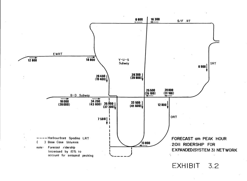
This is the companion chart from the Network 2011 study showing the projected demand on the rapid transit network with the addition of lines on Eglinton West, Sheppard, the DRL and the Spadina/Harbourfront line.


These two charts appear side by side in the Network 2011 study, but only the first one was included in the Improved Headway Study.

The DRL diverts a good chunk of traffic off of the Yonge line below Bloor, although this is partly backfilled by new riding pouring in at the top of the line. (Other studies had different versions of this line including routes that went further north.)

The projected demand on the Spadina line, 7,500 per hour, was rather high considering it was to be a surface operation crossing many streets. Oddly enough, only the Harbourfront portion was built initially, and we waited until 1997 for the Spadina streetcar.

I don’t intend this to be a definitive example of a demand model (I don’t think “definitive” is a word one can use in that context anyhow), but it points out how the importance of the DRL was recognized over 20 years ago. Indeed, in the Network 2011 plan, it was the second priority for construction with 1st place going to a Sheppard line only as far east as Victoria Park.

Yonge Subway Headway Study 1988 (Part 5)

In this section, we begin Chapter 4 of the study with a description of the centre platform option at Bloor-Yonge Station.

Some of the work needed for this scheme was built during construction of 33 Bloor Street East and the Toronto Parking Authority lot between Hayden and Charles Streets.  The TTC took advantage of the subway structure being uncovered to widen the station and replace the centre columns with a roof spanning both platforms and tracks.  As you can see from visiting the station, this work ends at the northern third of the station because this is physically inside the structure of The Bay.

The section on construction feasibility describes what is necessary to continue this layout further north and it involves, among other things, closing the Bay’s concourse during construction.  That entire passage is almost surreal because it details problem after problem with the construction, but forges bravely onward.  There’s also the small matter of closing Bloor-Yonge Station because the existing platforms must be removed before the tracks can be relocated.

Continue reading

Yonge Subway Headway Study 1988 (Part 4)

This installment completes Chapter 3 of the study with the evaluation of alternative signalling strategies.  The recommented alternative is Automatic Train Control, no surprise there, based on the premise that it provides the maximum benefit versus the expenditure.  Underlying this, however, is the goal of a 90-second headway and the increasing challenges to subway operations as the headway drops.  ATC is treated as a means to achieve this dubious goal rather than a worthwhile move in its own right.

Continue reading

Yonge Subway Headway Study 1988 (Part 3)

This section presents considerations for the vehicle fleet and yards required to house these cars.  An important consideration for any decrease in headway is that the number of trains in service goes up.  This generates added capital and operating costs for an expenditure that addresses only peak period demand.

A proper comparison of lines would look at what happens if the fleet is expanded (regardless of the technology) elsewhere so that new off-peak service is available in a corridor that does not now have rapid transit.

As we will see later, the additional vehicles are a substantial portion of the total project cost for peak headway improvements on an existing line.

Continue reading

Yonge Subway Headway Study 1988 (Part 2)

This thread began with an introduction to the “problem” of capacity at Bloor-Yonge Station which dates back to the 1980s, an era when all expansion of capacity for travel from the suburbs to downtown was assumed to be on the subway network.  If you accept that premise, then it follows that massive expansion of subway capacity is absolutely required.  However, as we have recently seen from demand projections by Metrolinx, when there are good alternatives to the existing subway, people may find other ways to get downtown.

In this section, I will present another chunk from the long Chapter 3 in the TTC’s 1988 study.  This part includes descriptions of four ways to achieve shorter headways on the Yonge line through signalling changes.

Continue reading

Yonge Subway Headway Study 1988 (Part 1)

Recently, there has been a lot of discussion here about the practicality and desirability of adding capacity to the Yonge-University subway.  My position is clear:  there is more to be gained by adding new capacity in other corridors that can, in addition to relieving pressure on the Yonge line, provide alternatives in the transportation network to what now exists.

For twenty years, the focus has always been on beefing up the Yonge line, and this reflects the TTC’s long-standing tradition of looking only at their network when planning transit capacity.  Earlier subway expansion schemes completely omitted the GO Transit network from calculating potential regional demand and modelled all growth in riding on the subway system.  The effect of this shows up in the Network 2011 proposal that projected large increases in subway demand.  Those increases triggered a study in 1988 of what could be done to add capacity to the Yonge line, and we are still living with some of the fallout from that study today.

When I dug the report out of my archives, I thought that I would only scan, edit and post a few chapters. However, I soon realized that the arguments of 20 years ago are worth reading today because they are instructive both for the basics of transit operations, and because they show the origins of some current thinking.

For convenience, I have chopped up the document into sections.  The text, which was originally doublespaced typewriter (Courier) format, has been converted to single spaced Times Roman (yes, I know some of you just hate Times Roman).  Some exhibits that didn’t lend themselves to text-based conversion have been scanned separately as jpegs.

The first installment (this post) contains chapter 2 and the first parts of chapter 3 of the Final Report (chapter 1 was the Executive Summary) dealing with the problem of projected congestion and the various ways in which signal changes could be used to reduce headways.  In the next installments, we will see:

  • detailed descriptions of four schemes for signalling changes to achieve closer headways
  • a discussion of vehicle requirements
  • conclusions and recommendations for signalling
  • four schemes for a reconstructed Bloor-Yonge Station
  • evaluation of impacts at other stations and terminals, notably Finch and Wilson
  • options for the Yonge-Spadina loop
  • final summary and recommendations

Chapter 4 (the Bloor Yonge schemes) contains useful material to those of you who have been, figuratively speaking, drawing lines on maps for the past few weeks with possible alignments for additional tracks.  It helps to know the lay of the land both above and below ground.

Because we have already had quite a lot of discussion about routing alternatives, I will exercise my editorial prerogative to delete or severely cut repetitions of past discussions.  The main reason I am putting this material up is to show what was actually considered and how the history of past studies like this colours future projects.  That’s an important context for the current Regional Transportation Plan discussions — things that seem trivial today will take on the aura of historical received wisdom in less than a decade.  Maps drawn on stone tablets are hard to change.

Continue reading