
In response to the “Toronto has the world’s slowest streetcars” meme floating around on line and among some transit advocates, various proposals were floated to speed up our system.
One of these is the idea that there are too many streetcar stops, and if only cars didn’t pause so often for passengers, we could have faster streetcar service. The TTC’s euphemism for this is “stop balancing”.
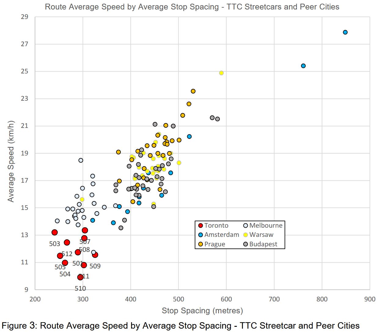
A chart accompanying the TTC report shows the speed and stop spacing values for several transit systems. Toronto is down in the left bottom corner with the closes stops and the slowest speed. However, Melbourne’s trams are in the same range as Toronto for stop spacing, but they operate faster. Nowhere does the TTC examine what differences might apply to Melbourne lines, nor for the other systems that are both faster and with wider stop spacing.
Although there are some outliers, the bulk of the data points are in the 400-500m range, but this does not examine route characteristics. The original study of slow Melbourne streetcars by Dr. Jan Scheurer commented about Toronto that “CBD-typical speeds seem to extend across the entire city” [p. 8]. Riders who sit in traffic jams on King or Queen Street West, or on Queen Street in the Beach are quite familiar with this problem. Toronto streetcars do not emerge from the core to fly into nearby suburbs.
There is also the issue that Toronto streetcars used to move faster both with the CLRV fleet and the PCCs that preceded them. Something beyond stop spacing is at work even on routes with dedicates rights-of-way. It is easy to go after stops as a source of delay because this would not require an examination of TTC operating practices and the City’s lack of aggressive transit signal priority. Indeed, during the last round of major works on St. Clair, it was discovered that TSP was not actually working in many locations.
For the sake of argument, assume that the delays to TTC streetcars come from closely spaced stops. Any rider knows that there are other factors including slow operation through junctions, traffic signals that do not give streetcars priority and congestion both in the core and the outer parts of many routes.
The premise is that fewer stops will speed service benefiting those already on streetcars at the expense of those who have to walk further to a stop. This is a bogus argument regardless of stop spacing. There will almost always be more riders passing any individual stop who would “benefit” from its elimination than riders who use the stop. The same argument could be made for some subway stations.
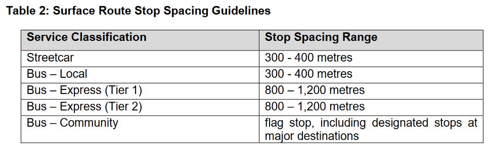
Here are the TTC’s Board-approved stop spacing standards. The target range of 300-400m for local surface routes implies an average stop spacing of 350m giving some leeway to adjust to conditions.
(To give readers a sense of distance, a subway station platform is about 150m long, and so a 300m walk is from one end of a station platform to the other and return.)
Streetcar route averages lie roughly in the 250m-325m range below the standard’s midpoint of 350m. Some stop trimming has already occurred to eliminate very closely spaced stops.
Note that 508 Lake Shore shows the same average as 507 Long Branch even though the 508 travels into the core. The reason is that the stop spacing between Humber Loop and Roncesvalles is quite wide, and this offsets the closer spacing on King Street in the average.
| Route | Termini | Stop Spacing (m) |
|---|---|---|
| 501 Queen | Neville-Roncesvalles (*) | 241 |
| Roncesvalles-Humber | 448 | |
| 503 Kingston Road | Victoria Park-York | 284 |
| 504 King | Dundas West Stn-Distillery (*) | 283 |
| Dufferin Loop-Broadview Stn (*) | 280 | |
| 505 Dundas | Dundas West Stn-Broadview Stn (*) | 278 |
| 506 Carlton | High Park-Main Station (*) | 260 |
| 507 Long Branch | Long Branch Loop-Humber Loop | 312 |
| 508 Lake Shore | Long Branch Loop-Distillery | 306 |
| 509 Harbourfront | Exhibition-Union Station | 373 |
| 510 Spadina | Spadina Station-Queens Quay | 293 |
| 511 Bathurst | Bathurst Station-Exhibition Loop | 328 |
| 512 St. Clair | Gunns Loop-St. Clair Station | 270 |
Notes:
- 501 Queen stop data are taken from the pre-Ontario Line construction with service running directly across Queen from Church to York.
- Stops near Dundas West and Broadview Stations that are used primarily by overnight services have not been included in the stop counts for 504 King and 505 Dundas.
- 506 Carlton stop data are taken from the through route before construction diversion around Bay & College.
Some Basic Math
If one wants to achieve a major saving from stop time, many stops have to be cut on a route. One or two will annoy their regular users, but the change in travel time, if any, will be quite small and disappear into the background noise of other variations.
The basic calculation is simple: if a route now has an average spacing of 300m, and you want to raise this to 400m, then one quarter of the stops must vanish. The bigger the change in stop spacing, the more stops must be eliminated.
The numbers of stops for various spacings per 1km are shown below:
- 250m: 4.0
- 300m: 3.3
- 350m: 2.9
- 400m: 2.5
- 450m: 2.2
- 500m: 2.0
With the TTC standard of 300-400m, 350m falls half way along, or 2.9 stops/km. Just to bring routes now at a 250m spacing (4.0/km) to that level would require a reduction of about 1.1 stop/km, or about 12 stops each way on a route the length of 505 Dundas (11km).
If the goal is to move to a 400-500m standard, this means the new target average would be 450m. A route whose average is now 250m would lose almost half its stops. This would be extremely difficult as routes do not have that many “unimportant” closely-space stops to begin with.
The effect would not be on a few riders at a few minor stops, but on many riders all along the routes. They would face extra walking distance lengthening overall travel times, not to mention accessibility issues for those with mobility challenges.
A simple, but important, number is not the space between adjacent stops, but the space that would result if any stop were removed. (In other words, the space between stop N and stop N±2.) In some cases, the existing TTC standard would still be met, but in many the gap between stops would be well outside the standard. For example, if three stops are each 300m apart, getting rid of the middle one creates a 600m gap, well above the standard.
Stops cannot simply be re-spaced to maintain uniformity or iron out problems with stop elimination. For pedestrian safety, stops are almost always at signaled intersections or at least at pedestrian crosswalks so that riders can cross safely to/from stops on the opposite side of the street. The existing street layout, signal patterns and major destinations such as transfer points determine where stops might go. Toronto, unlike Manhattan, does not have a repeating grid as a base for designing standards.
In the sections that follow, I will turn to a few sample routes. There are occasional closely-spaced stops, some with good reason, but not many are ripe for plucking without adopting a considerable increase in the standard and substantial cut to the number of stops. This should be a conscious policy debate, not a change buried in a wider review of Service Standards without a clear indication of the effects on routes across the city.
Continue reading