This is the fifth and final article in a series reviewing the construction effects of the Ontario Line downtown. It deals with overall issues across the project rather than the specific issues at each station.
In reading the report, there is a sense that working out traffic flows for motorists and trucks took a much higher priority than thinking about transit, pedestrians and cyclists.
The Ontario Line stations are projects on a scale and time frame larger than major building construction projects, and the work will be undertaken by an agency that is not noted for its sensitivity to local concerns. If Eglinton was any indication, there will be plenty of opportunity for finger-pointing between Metrolinx, the City and “Project Co.” (the placeholder name for the yet-to-be-selected P3 partner).
City Led Projects
In addition to the work of building the Ontario Line, there are other planned construction projects downtown. The list below only reaches to 2026.
The following City-led construction projects were included:
Gardiner Express Rehabilitation – Grand Magazine Street to York Street (2024 to 2026)
TTC 504 King streetcar track rehabilitation – 2024
Yonge Tomorrow – Reconfiguration of Yonge Street between Queen Street and College Street
Sewer Rehabilitation –
Richmond Street between Simcoe Street and John Street (2023);
Richmond Street between Peter Street to Spadina Avenue (2023);
Wellington Street between Clarence Square and Blue Jays Way (2024);
Front Street between Bay Street and Scott Street (2024).
Watermain Replacement –
Adelaide Street between York Street and Victoria Street (2022);
Dundas Street, between Church Street and Sherbourne Street (2024);
Front Street between Bathurst Street and Spadina Avenue (2026).
Congestion
The table below shows the effect of various configurations on traffic volumes and speed for the AM and PM peak periods.
The Base Case is the existing conditions with no added projects.
The “Future Background” adds in the City projects listed above, and assumes that they all happen at once. In fact they will take place at different times.
The “Future Total” adds in the effect of the Ontario Line construction on top of the City projects.
The base number is the projected vehicle count on each corridor at Yonge Street. The number in square brackets shows the existing travel time (Base Case) and the projected change (Future Cases) between Parliament and Bathurst Street.
King is notable by its absence in the table, but it is hard to believe it will not be affected especially with the lack of enforcement of priority measures. It will be under construction in 2024, but in other years traffic will inevitably use any available street regardless of signage or paint on the roadway.
Travel times are already considerably higher in the PM peak than in the AM. The projected changes in the AM peak are small relative to the base case because the road network can absorb the reduced capacity at that time. However, in the PM peak, travel times double (or more) across the core area.
This will have a severe effect on transit service.
Considering the cataclysmic effects shown above, this table bears close scrutiny. An immediately obvious point is that almost all of the change is the result of the City-led projects and the Ontario Line construction adds very little on top of this. But the model assumed that all of the City projects planned out to 2026 would occur at the same time rather than individually.
This is lazy modelling, and it should be redone on a year-by-year basis to evaluate the effect of taking specific chunks out of the road network as planned.
Equally important should be a model run with only the Ontario Line changes included. It is possible that the model with only all of the City projects yields so much congestion that there is no room for “growth” on that account when the OL is added to the mix.
A rather obvious question here is how construction vehicles are supposed to access the OL sites if traffic is so congested during part of the day. Indeed, one might ask whether a moratorium on truck activity during at least the PM peak will be needed.
A well-known characteristic of traffic congestion is that it can build slowly with volume, but at a critical point there is a “knee in the curve” where congestion gets much worse with only a small change in the network. This is seen on a day-to-day basis when all that is needed to snarl an otherwise open road is a curb lane blocked by a delivery truck or utility workers with a few traffic cones.
This is the fourth article in a series about the anticipated effects of construction through downtown of the Ontario Line. Because the stations at Moss Park and Corktown are similar in their construction technique, I have grouped them together.
Both stations will be built as off-street using cut-and-cover rather than mining because the entire station site can be opened for access. Effects on pedestrians are less severe, and transit stops are undisturbed.
However, the scope of work is much greater at Corktown Station because this will be a Tunnel Boring Machine launch site. Not only will this see the excavation of the station itself, but the removal of “muck” from the TBMs as they progress west across the route.
This is the third article in a series about the anticipated effects of construction through downtown of the Ontario Line. Because the stations at King/Bathurst and Queen/Spadina are similar in their construction technique, I have grouped them together.
Two of the four corners at each intersection will be used for excavations down to the tunnels which will exist by the time station construction begins. The plan is to avoid road closures that would disrupt transit service, not to mention capacity on the road network.
This may sound good in theory, but transit service will suffer from new pinch points in the road network, and pedestrians will attempt to make connections between transit routes walking along roadways adjacent to construction zones. Although there are no formal cycling lanes on streets at either station, a substantial volume of cycling traffic now uses curb lane space that will disappear.
In both cases, construction is planned to run from July 2022 until mid-to-late 2029.
July 2022 to June 2023: Setup, utility relocation and enabling works
July 2023 to March 2026: Excavation
March 2026 to September 2027: Below grade concrete work
Fall 2026 to Fall 2027: Exterior station work
June 2027 to September 2028: Interior station work
March 2028 to March 2029: Station fit out and testing
There is no plan to selectively re-open parts of the street once the major works of excavation and concrete pours are out of the way.
An obvious issue for the long term is that no sooner will subway construction decamp from these sites, but new building construction will move in. The loss of sidewalks and road space could continue well into the 2030s.
When I asked the City of Toronto about this, they understandably have no information on the time frame or effects of potential developments of these “Transit Oriented Community” sites to be developed by Infrastructure Ontario.
[…] although these sites have been flagged as TOC’s we don’t currently have any details around these and their construction impacts. If lane closures are required for their construction then reports will need to come forward to City Council at the appropriate time which will spell out the occupations required and impacts.
Ashley Curtis, Director Transportation Planning & Capital Program. Dec. 2, 2021.
This continues the series reviewing the construction plans for downtown stations on the Ontario Line and their effect on roads and nearby properties.
Like Queen/Yonge station described in the previous article, Osgoode connects with the Line 1 subway in a new two-level station. However, the construction approach will be completely different.
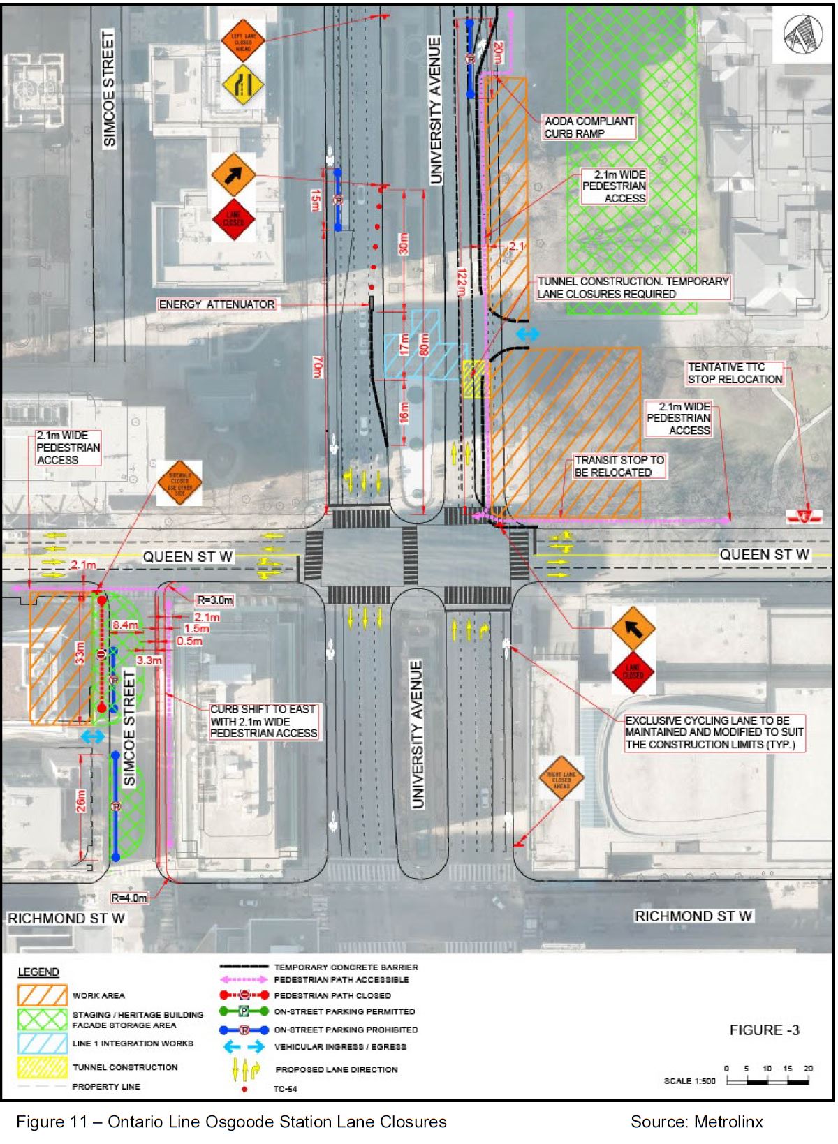
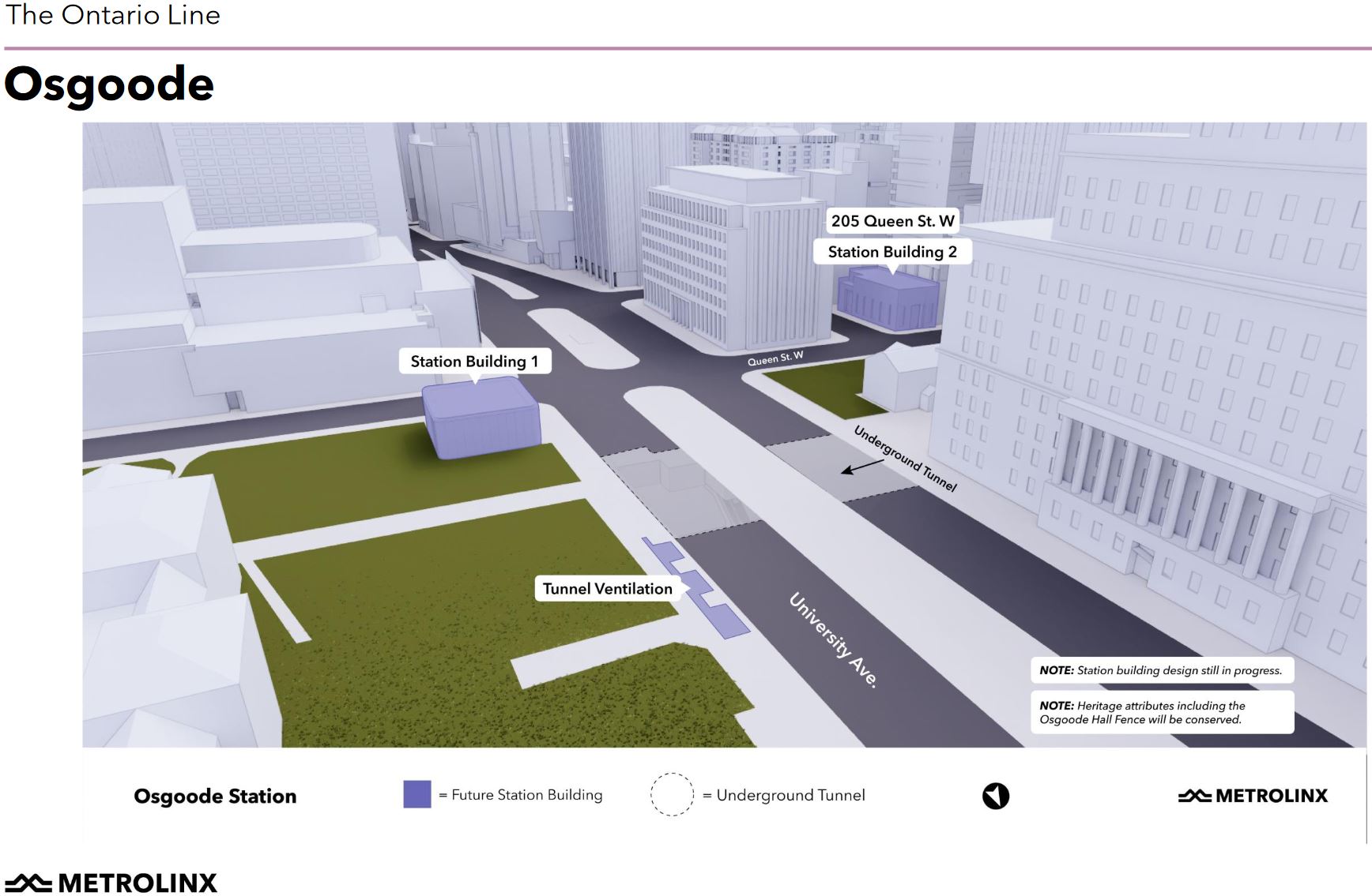
The expanded Osgoode Station will be dug from two excavations at opposite corners of the station rather than from access pits in the middle of Queen Street. The primary entrance to the expanded station will be at the northeast corner of University and Queen, a space now occupied by part of the park in front of Osgoode Hall.
A second entrance to the station will be built at Queen and Simcoe and will use the existing bank facade for its exterior.
The diagram below shows a much larger portion of this park to be occupied for construction than was previously thought to be threatened. Compare the orange hatched area below with the next drawing from the June 2021 round of consultations.
This drawing shows “Station Building 1” occupying about half of the frontage on University between Queen Street and the gate to the walkway across the front of Osgoode Hall. In the diagram above, the entire width of this area is taken for construction as well as part of the area north of the walkway along the street, and the lawn in front of the Hall.
Given the effect any work within the Hall’s grounds will have on the park, this is not a trivial change. Quite bluntly, I believe Metrolinx showed the smaller scope in the drawing above because proposing to take so much of the park, even temporarily, would have produced an uproar. They stick handled their way around any discussion of Osgoode Station during the consultation sessions. This has the smell of deliberate misrepresentation.
If anyone is considering a design based on a proposed reallocation of lane space on University and expansion of the east side pedestrian realm, they have been very quiet about it. Conveniently for Metrolinx, this is not a residential neighbourhood with the usual population of critics quick to leap on their proposals.
All of the trees at Osgoode Hall in the photo below lie on lands shown as the construction zone for this project. Civic vandalism in the name of “progress” does not begin to describe this proposal.
University Avenue Looking North at Queen, June 2021 / Google Street View
Early Works
The main construction work begins in July 2023 with station excavation running to March 2026. The station exterior would not be complete until Fall 2027, and the lane closures would not be undone until sometime in 2029. (See the city’s report for details.)
However, some works must take place in advance of the main project:
Utility relocation from March 2022 to May 2023.
Other “setup, preparatory and enabling works” from July 2022 onward. It is not clear just what these entail or which areas of the site would be affected.
At various times in 2022 there will be short-term closures of parts of Simcoe Street and University Avenue (see the list of Early Works closures for details).
Street Restrictions
For much of the project, various lanes and parts of sidewalks will be close or restricted:
Queen Street road lanes will not be affected.
On the east side of University to north from Queen (see photo above), the street is now four lanes wide with the curb lane used for a bike path. In this area, the sidewalk will be taken over for construction and pedestrians will be shifted into what is now the northbound curb lane.
NOTE: The report is unclear about whether there will actually be a cycling lane or not, or when. “The existing northbound curbside bicycle lane on University Avenue fronting the Osgoode Hall will be closed for construction staging purposes. However, the northbound travel lanes on University Avenue will be realigned and a protected 2.0 metres wide northbound bicycle lane around the work zone will be provided.” [p 28]
On Simcoe Street, the west sidewalk and part of the street will be closed between Queen and the laneway running midblock west from Simcoe. The intent is to use the west side of Simcoe as a staging and storage area.
The east sidewalk on Simcoe will be narrowed to leave enough room for one traffic lane and a cycling lane, although that lane is not shown clearly on the drawing above.
Pedestrian access will be maintained in front of the bank/second entrance building along Queen west of Simcoe.
Here is what Simcoe Street looks like today. The bank on the left will become the second station entrance.
Simcoe Street Looking North to Queen Street June 2021 / Google Street View
Transit Changes
The only explicit changes proposed for this area are the relocation of the westbound streetcar stop east to a point clear of construction, and closing the existing station entrance north of Queen on the east side of University.
The report proposes a westbound York/University stop on Queen, but this would be closely after streetcars have stopped northbound on York at Queen. With the northeast station entrance closed, passengers transfer passengers are more likely to use the southeast entrance (through the Opera House) and a stop on the north side of Queen does not make sense. Better that transfers walk between the Opera House entrance and the proposed stop at York & Queen along the south side of the street.
The eastbound stop on Queen at University will remain.
Metrolinx has not published diagrams of Osgoode station below street level showing how the existing and new spaces and circulation patterns will work.
In the next article, I will review King/Bathurst and Queen/Spadina stations.
This is the first of a series of articles reviewing the plans for construction of the downtown Ontario Line stations between King/Bathurst and Corktown Station. The base document is a report at the Toronto Executive Committee’s meeting of December 7, 2021.
Appendix C – Key Intersection Measures of Effectiveness
This is a long report detailing the effect of multi-year construction at six sites. Beginning with early works in 2022 and continuing to 2029, each of the sites will be at some stage in construction, although the exact timetable varies from station to station.
The project will involve many curb lane closures and associated effects on sidewalks, bike lanes and transit stops. As previously reported, there will be a complete road closure of Queen from Bay to Victoria for the construction of a deep and complex link there to the existing Line 1 Queen Station. Osgoode Station is a less complex project because there are fewer nearby buildings constraining the site, although it has its own challenges.
King/Bathurst and Queen/Spadina are similar to each other in that they will use shafts on two of the four corners of their intersections as the launch points for mining out the station caverns under the street.
Moss Park and Corktown Stations are both cut-and-cover locations, but Corktown has the added complexity of also being a site for the tunnel boring machine launch and for removal of spoil from the tunnel excavation.
Each site has other issues:
Volume of spoil from the excavations and the routes trucks will use to move material from six concurrent construction sites.
The constraints on emergency vehicles while road access is limited.
Local business and residential access.
Cycling lane effects.
In all of this, we must assume that traffic, transit, pedestrian and cycling demand will be at least at pre-covid levels, although there are likely to be shifts as some traffic “evaporates” in frustration.
This first article will deal with the most complex project: Queen Station. Next will come Osgoode, to be followed by the two western stations at Bathurst and Spadina, and then the eastern stations at Moss Park and Corktown. I will wrap up with a discussion of issues common to all sites.
Correction: Metrolinx has advised community members that the pop-up at Frankland School is one of a series of such events and is not intended as a formal consultation session given with almost no notice.
In their continued goal of always being right (one might say “Resistance Is Futile”), Metrolinx has published another article about why we just must have the Don Valley Layover track on the former Don Branch from roughly Rosedale Valley Road to the “Half Mile Bridge”.
There is little new in this article which re-iterates much previous material, but at greater length in an attempt to appear oh-so-reasonable.
Of particular interest is the sense that after resisting community input, Metrolinx appears to be softening their position. “Appears” is the operative word here.
While working on that, Metrolinx is making sure to protect the Don Valley, as the area sees this work to come later this month (December).
• Arborists (tree experts) will evaluate trees in the vicinity of the proposed layover • Biologists will assess the habitat features in the adjacent area • Heritage experts will assess any impacts on heritage features in the area including the Prince Edward Viaduct • Engineers will assess the current infrastructure.
Metrolinx initiated a procurement process for the technical advisor that will advance the design for the layover facility. In addition to architects and engineers, this team will include landscape architects and restoration experts.
Metrolinx expects to have the consultant on board early in 2022 to begin the initial design and work with the community.
What is not clear is whether there will actually be any change to the proposed design, or if this is a typical “consultation” where the community gets to choose the colour of the wallpaper.
There will be a pop-up consultation at Frankland School tonight (Dec 2) starting at 4:30 pm. What, you say you don’t know about this? That’s no surprise as Metrolinx does not mention it on their own engagement site, and few people who live in the area have heard of it. However, in due course it will serve the purpose of reassuring Metrolinx Board members and politicians that there has been “consultation”.
See correction text at the beginning of this article.
Metrolinx claims that the Don Branch is the only suitable location, but they have never addressed key questions:
Metrolinx claims that the “Rosedale Siding”, a second track on the GO Richmond Hill corridor west of the Don River, cannot be used for storage as it is required as a passing track. (Indeed with the recent diversion of VIA trains over this route, GO and VIA trains passed each other using this siding.) However, they fail to acknowledge that the right-of-way held three tracks, not two, in the past, and that a third track could be restored. (See photos in this article.)
Metrolinx claims that support buildings are required at this location even though a similar storage facility on the Lakeshore East corridor at Midland has no buildings and trains are simply parked there.
Metrolinx has not addressed a proposal to place the support buildings and parking, to the extent that they are actually required, at the north end of the layover track beside the Bayview/DVP connection road rather than at the Viaduct.
Metrolinx plans to use the Richmond Hill corridor as a turnback area for trains at Union Station. However, they are electrifying double track all the way to Pottery Road, far further than is needed as a turnback facility. This implies that the line will be used for something else, possibly storage of trains, but Metrolinx is silent on this.
Metrolinx talks about reduction in the footprint of the layover facility, but this typically refers to revisions made a few years ago when the proposed location was changed and some of the buildings were redesigned. They have not addressed why the buildings are needed if only between-rush hour storage is planned, as opposed to the ovenight operations that were contemplated in the original scheme.
By conflating changes made in the past with current community criticism, Metrolinx implies that they are altering their scheme today. That is misleading, as parliamentarians would say.
The whole matter of Metrolinx’ relationship with trees is fraught on many of their projects. Of particular concern is that they bring in an arborist to review the situation well after they pass the point of no return in design lockdown.
The site review they now plan is rather odd considering that the Environmental Assessment and Site Selection processes are complete. If they are truly contemplating reopening the question, this would run contrary to their approach on many projects where “consultation” proceeds while Metrolinx assumes that nothing will change and plans accordingly.
In a separate article, Metrolinx claims that the area to be occupied has already been disturbed by construction.
Placing these buildings immediately north of the viaduct will take advantage of construction that has already been done in the area. This is an area where green space was previously disturbed during the rehabilitation of the viaduct and there is already an access road in place to support an adjacent hydro facility.
That statement might have been valid for the originally proposed location south of the Viaduct which was used some years back as a staging area for work on the bridge. However, the area north of the Viaduct is treed as anyone can see looking down from the subway on the viaduct, and as I can simply by looking out my apartment window. Even the staging area south of the bridge has grown back in, and the idea that it is expendable because it was “disturbed” is no longer valid, but it suits Metrolinx to misrepresent actual conditions.
(For the record, I live in the building at the upper right of this image.)
Google Earth June 2021
At the heart of this debate is a fundamental distrust of Metrolinx’ intentions based on their dealings with many communities in many projects. “Trust” is not a word one would use.
I have no illusions that this work will be stopped, but wish that Metrolinx would stop trying to prove “the community” wrong and address real concerns about their proposals. This is a small part of a much larger project, but it shows just how things can go wrong with “public participation”.
From time to time, I am asked about the TTC streetcar replacement policy and some of the history. To flesh out some of this, I have scanned three reports of interest.
1952: Buying Used Streetcars
In 1952, the TTC was still acquiring second-hand PCCs from other cities, but planned eventually to replace all of their streetcar lines by 1980 when subways downtown would make the streetcar lines obsolete.
This is a scan of a photocopy of a carbon copy of a typewritten report. [26MB PDF]
This report shows the TTC’s thoughts on the future of its streetcar system from just before the Yonge subway opened, and how it would be an important part of the network until about 1980.
The importance of the Bloor-Danforth corridor can be seen in the following text:
The Service Change Committee estimates that after the subway is in operation the Bloor service will require 138 cars for through service over the whole route, plus 36 cars for short-turn service between Yonge and Coxwell, or a total of 174 cars.
No present-day route comes close to requiring this much equipment to handle passenger demand.
A longer extract is worth highlighting:
At the present time … there are available good, used, P.C.C. cars of recent manufacture which are suitable for operation in Toronto. This situation will obviously only continue for a limited time. It is believed that the Commission should seize the opportunity to protect its future by the purchase of some of these cars.
It might be asked why Toronto should consider buying additional street cars when so many of the transit properties on this continent are giving them up and turning to trolley coaches, buses or rapid transit operation. It is, therefore, necessary and useful to examine the practice as to vehicular service, past and present, of other transit properties to determine what course should be followed in this city.
It is more or less true that there has been a gradual abandonment of street cars in a substantial number of large American cities and some smaller Canadian cities.
There is obvious justification for the abandonment of street cars in smaller communities but the policy of abandonment of the use of this form of transportation in the larger communities is decidedly open to question. In fact it is hardly to much to say that the results which have occurred in a good many of these larger cities leaves open to serious question the wisdom of the decisions made.
It may be not wholly accurate to attribute the transit situation in most large American cities to the abandonment of the street cars. Nevertheless the position in which these utilities have now found themselves is a far from happy one. Fares have steadily and substantially increased, the quality of the service given, on the whole, has not been maintained, and the fare increases have not brought a satisfactory financial result. Short-haul riding, which is the lifeblood of practically all transit properties, has dropped to a minimum and the Companies are left with the unprofitable long-hauls. Deterioration of service has also lessened the public demand for public passenger transportation. The result is that the gross revenues of the properties considered, if they have increased to any substantial degree, have not increased in anything like the ratio of fare increases, and in most cases have barely served to keep pace with the rising cost of labour and material. It is difficult to see any future for most large American properties unless public financial aid comes to their support.
These facts being as they are, Toronto should consider carefully whether policies which have brought these unfortunate results are policies which should be copied in this city. Unquestionably a large part of the responsibility for the plight in which these companies find themselves is due to the fact that the labour cost on small vehicles is too high to make the service self-sustaining at practically any conceivable fare.
Why then did these properties adopt this policy? It is not unfair to suggest that this policy was adopted in large part by public pressure upon management exerted by the very articulate group of citizens who own and use motor cars and who claim street cars interfere with the movement of free-wheel vehicles and who assert that the modern generation has no use for vehicles operating on fixed tracks but insists on “riding on rubber”. If there is any truth in the above suggestion it is an extraordinary abdication of responsibility by those in charge of transit interests. They have tailored their service in accordance with the demands of their bitter competitors rather than in accordance with the needs of their patrons.
The report goes on to talk about both the deterioration of physical plant and equipment in many cities, but not in Toronto, as well as the very high demands found on our street car routes.
Even if the Queen subway were to open “in the next decade”, the initial operation of this line would be with streetcars and the TTC would continue to need a fleet. This statement was made at a time when the Queen route, rather than Bloor, was seen as the next rapid transit corridor after Yonge Street.
The report recommends purchase of 75 used cars from Cleveland, 25 of which had been built for Louisville but barely operated there before that system was abandoned. The TTC already had second-hand cars from Cincinnati, and would go on to buy cars from Birmingham and Kansas City.
1971 and 1972: The Beginning of the End?
In 1971 and 1972, the TTC was still discussing their plan for a Queen Street subway, although it was looking rather uncertain as a project. As we all know, it did not open in 1980.
The 1971 report sets out a plan to discontinue all but the core routes of King, Queen (including Kingston Road) and Bathurst, with even these up for grabs should a Queen subway open in 1980, rather far-fetched idea for late 1971 and an era when all rapid transit planning focused on the suburbs.
This is a scan of an nth-generation photocopy and it is faint in places because that’s what my copy looks like. [6 MB PDF]
The 1972 report set in motion the political debate about the future of streetcars, and led to the formation of the Streetcars for Toronto Committee. Had its recommendations been adopted, the removal of streetcars from St. Clair would begun the gradual dismantling of the system.
It is amusing to see the sort of creative accounting by the TTC that we in the activist community associate with more recent proposals. There is an amazing co-incidence that the number of spare trolley coaches exactly matches the needs of the streetcar retirement plan for St. Clair even though this would have actually meant a cut in line capacity. Moreover, the planned Spadina subway would lead to an increase in demand as St. Clair would be a feeder route.
There is also the wonderful dodge that if the TTC abandoned the streetcars and claimed it was for the Yonge subway extension, they hoped to get Metro Council to pay for some of the conversion cost out of the subway budget.
In this report (as well as in the 1971 report above) we learn that the Dundas car just had to go because its continued operation would interfere with the planned parking garage for the then-proposed Eaton Centre.
Note: My copy of this report was in good enough shape to scan with OCR and convert to text rather than as page images. The format is slightly changed from the original, but all of the text is “as written”.
The Streetcars Survived, But the Network Did Not Grow
In November 1972, the TTC Board, at the urging of Toronto Council, voted to retain the streetcar system except for the Mt. Pleasant and Rogers Road lines. The former would be removed for a bridge project at the Belt Line, and the latter was in the Borough of York who wanted rid of their one remaining streetcar route.
The TTC had a plan for suburban LRT lines in the 1960s, but this was not to be. While Edmonton, Calgary and San Diego built new LRT, Toronto’s transit future was mired in technology pipe-dreams from Queen’s Park that bore little fruit and blunted the chance for a suburban network while the city was still growing. It is ironic that growth in the streetcar network, if it comes at all, will be downtown thanks to a renaissance of the waterfront when it could have happened decades ago while much of suburbia was still farmland.
Little has changed in the transit projects, but IO and Metrolinx are shifting away from their original, much-ballyhooed model where public contract risk was minimized by a transfer to the private sector. Instead there is more talk about collaboration and mechanisms to make contracts more palatable to would-be bidders. It is no secret that a few years ago a major firm refused to bid on Metrolinx work on the proposed terms.
Building on the experience of the collaborative Alliance model in use for the Union Station Enhancement Project, IO’s partnership with Metrolinx to expand the GTHA’s network of public transit continues to advance and evolve. Last month, Metrolinx and IO launched the RFQ for the Scarborough Subway Extension – Stations, Rail, and Systems project, introducing a Progressive Design-Build approach. Like the Progressive P3 procurement strategy being introduced on hospital projects, the subway extension procurement includes the benefits of working with a partner on design work, addressing and avoiding considerable contract risk prior to signing a final contract to deliver the project. Following considerable discussion and consultation with industry, this complex, multi-billion-dollar project will be contracted as a targeted price versus the fixed price of our P3 models.
Like our contract packaging strategy for both Scarborough Subway Extension and Eglinton Crosstown West Extension, we expect to take a multi-package staged approach of delivering the Yonge North Subway Extension. That work would begin with an advance tunnels package that we expect to be procured using a classic DBF contract. Pending government approval, our hope is to have the RFQ for that procurement in market early next year.
Letter from Michael Lindsay, CEO of IO, October 14, 2021
The update contains projects from multiple ministries and agencies, and I have extracted the transit projects in the table linked below. This table shows the status of each project as it appears in the quarterly IO updates with the current changes highlighted in yellow.
The structure of the Scarborough Subway Extension has been changed from “TBD” to “Progressive Design Build” where first a partner is chosen with a Development Phase Agreement, and then a Project Agreement once design reaches the point of locking in the construction phase. Note that “Design Build” does not include operation and maintenance as the SSE will be part of the TTC’s subway system.
The Yonge North Subway Extension to Richmond Hill has slipped slightly for issuance of the Request for Qualifications and of the Request for Proposals, but this is offset by moving the contract award up from Fall to Summer 2023.
Several GO Transit projects are listed for award in 2021, but they have not yet been announced.
Beyond the works already in progress, no transit projects are up for award before Fall 2022. This means that if the Ford government is re-elected, they will have batch of ready-to-go announcements, but if not, there would be a last ditch chance to review some contracts either as to content (project details) or future operating principles (private vs public). Whether a Liberal or NDP government (or a coalition) would do this remains to be seen.
Updated October 14, 2021 at 12:50 am: Metrolinx’ responses to the absence of material on Osgoode Station, and of the suggestion of “ballot stuffing” have been added.
After the recent online consultation session for the Downtown Segment of the Ontario Line (Osgoode to Corktown), several issues came to mind and I wrote to Metrolinx for clarification. They have not yet answered most of them.
The Depth and Complexity of Queen Station
The cross-section for Queen Station included in the presentation shows an Ontario Line deep underground. This station is deeper than the City Hall Station on the Relief Line which was located immediately west of Yonge Street.
City Hall Station Cross Section Looking North, Relief Line. Source: Relief Line South Detailed Design
These two drawings are not at the same scale. The illustration below clips portions of each with scales adjusted to match. In both designs, the new structure leaves a gap below the existing station for structural support. However, with the Ontario Line directly under the Yonge Line, the concourse level (one above platform level) cannot share the same vertical “slice” that the Relief Line, offset from the Yonge Line, uses. This forces a deeper station than would otherwise be needed.
Metrolinx claims that transfer times between the two stations are actually shorter for the Ontario Line than the Relief Line, but this is hard to believe considering that OL riders must walk east or west at the concourse level just to reach an escalator upward from what would have been platform level on the Relief Line.
Note that in both cases, the level of the passageway under Queen Station (the remains of a never-used Yonge Station on a Queen line) connect to the circulation system of the new station. It is not clear, however, that the capacity of the existing passage, stairs and escalators is up to the potential level of transfer traffic. That problem is common to either design.
What Is Happening at Osgoode Station?
The meeting announcement clearly states that Osgoode Station would be up for discussion. This is a controversial site where Metrolinx plans to build a new entrance and access shaft where there is now a grove of trees on the northeast corner of Queen Street and University Avenue at Osgoode Hall. See: Ontario Line v Osgoode Hall. Trees on main streets downtown, let alone on an historic site, are not exactly common, and the Metrolinx plan verges on civic vandalism.
In particular, there is a proposal floating around at City Hall to substantially reconfigure University Avenue by extending the east sidewalk (shown below) into the northbound roadway. The trees at Osgoode Hall are an integral part of the new design.
This locations of station entrances for the Ontario Line are different than in the original Relief Line plans because the OL station box is shifted west. (See the article linked above for detailed layouts.) The Relief Line station ran from just west of University to York, with a new expanded entrance on the southwest corner at University and a completely new entrance at York and Queen. The Ontario Line station runs from west of Simcoe to University with new entrances through the Osgoode Hall lands and through an old bank on the southwest corner of Queen and Simcoe.
This is a controversial subject, and Osgoode Station was included in the announced meeting agenda. This agenda is still online on the meeting page. Clearly when this meeting was announced Metrolinx intended to include Osgoode Station.
That page now claims:
The presentation focused on timely updates for Queen, Moss Park and Corktown Stations. While this presentation did not feature an update on Osgoode Station, the panel welcomed and responded to questions about all four stations within the segment.
That is flatly not true. A few people asked about Osgoode Station’s absence from the presentation, but there was no substantive discussion because no material was presented.
Metrolinx has not yet posted any replies to the questions submitted online, but there is an added wrinkle in that regard. There had been a popular question about Osgoode Hall that ranked third on the list on September 28.
By October 12, this question had gained more support, but also a large number of down-votes pushing it well down the list. One might speculate that this is a question Metrolinx would prefer not to answer. In this age of challenged votes, we cannot tell whether any ballot-stuffing was involved. (See Metrolinx’ reply at the end of this section.)
I asked Metrolinx about Osgoode Station’s absence from the actual agenda, and here is their reply:
The Ontario Line virtual open house on October 7 did focus on the Downtown segment, which includes Osgoode, Queen, Moss Park and Corktown Stations. However, similar to other open houses we have hosted across the alignment, we did not feature an update on all stations in the segment.
As you noted, we did not include new information about Osgoode Station in the October 7 presentation. There are a few reasons we did not cover Osgoode in the presentation. First and foremost, we did not have significant updates to share about the station. Additionally, we aim to keep the presentations to 30-minutes to allow ample time for questions. Given that we had substantial updates to cover for all of the three other stations but not for Osgoode, we did not explicitly highlight this station during the presentation. Nonetheless, we welcomed questions related to all Downtown stations and will post responses for any questions we did not get to answer during the live event in the coming weeks.
We look forward to bringing new updates and more information to the community about all stations across the Ontario Line as they are available. We also always welcome questions and feedback via email, phone, and social media. Anyone interested in learning more about any station can also visit our website or book a meeting with a community relations team member.
Email from Caitlin Docherty, Community Relations & Issues Specialist – Ontario Line, October 12, 2021
To have no update on a controversial station site, if only to say “we have some ideas and we’re working on it”, suggests avoidance, not merely a desire for brevity. Moreover, there was no suggestion during the meeting of an alternate date when that site could be discussed.
This is not a trivial issue both in its own right, and because Metrolinx operates to a clock ticking quickly and inexorably on a compressed approval timetable. Delaying discussion makes real debate, let alone the possibility of modification, more difficult.
It is all very well to suggest that people can contact Metrolinx one-on-one, but this is not the same as a published community meeting where whatever claims Metrolinx makes are public and can be challenged. Even in public meetings, Metrolinx makes statements that can be charitably described as misinformed. They can claim to have “consulted”, ticking off a box in the legislated process, but without a public check on their accuracy.
Updated October 14, 2021 at 12:50 am:
Metrolinx has replied further:
Consultation is absolutely planned once we have new significant updates to share for Osgoode. During the virtual open house, we welcomed questions related to all Downtown stations and will post responses for any questions we did not get to answer during the live event in the coming weeks.
I want to be very direct with the second half of your email. Metrolinx does not manipulate the votes in any way on Metrolinx Engage. We use the votes to gauge community interest and determine which questions we will have time to answer.
Email from Daryl Gonsalves, Community Relations & Issues Specialist – Ontario Line, October 14, 2021
I will take this at face value, but it is clear that somebody really didn’t want to have a discussion about the trees at Osgoode Hall.
More Questions
The following questions to Metrolinx await answers.
Queen Station
At Queen Station, you stated that the transfer with Line 1, although obviously deep vertically, is shorter than from the originally proposed City Hall station on the Relief Line South. This is hard to believe. Can you explain further?
Was there any reason for the change in the OL elevation other than the geometric constraint at Yonge caused by shifting the station eastward?
From a construction point of view at Queen Station do you plan to dig two shafts down east and west of Yonge, and then mine inward from the sides?
With the station at Yonge now being an entire level below the RL plan, what does this do to elevations at Osgoode and Moss Park compared to the original RL designs?
Moss Park Station
At Moss Park Station, you talked about meeting the fire code while only having one exit building. I have been trying to figure out the plan in the presentation deck. Am I right in thinking that there are two separate sets of vertical access from the common lobby area leading to different parts of the station? How do you achieve compliance with only a single exit point? This was a known advance question and simply including a station plan would have answered this.
Corktown Station Construction Effects
There was a passing reference re the construction disruption at Corktown where you talked about the possibility that the tunnel will be one straight bore from Corktown to Exhibition rather than two separate ones east and west of Yonge Street.
Is this a decision being left to the south tunnels bidders? It obviously has significant effects on construction staging and the length of disruption at Corktown.
On a related note, how do you plan to construct the segment between Corktown and the portal west of the Don River?
Station Finishes
There was a question about station finishes where the answer quickly pivoted to the joys of above-ground stations and sunlight. This has nothing to do with downtown, underground stations. Do you plan simple bare concrete stations for the Ontario Line or not?
Updated October 27, 2021 at 12:15pm: The link to the TTC’s Line 3 Replacement page has been updated to point to their new website.
In July, I wrote about the first round of consultations and option evaluations in What Bus Service Will Replace the SRT? Please refer to that article for information about the original long list of options. Many variations were scored, but only a few made it through to the final selection.
In January 2022, staff will take their recommendation to the TTC Board. There are three options still on the table, but option 1 will be recommended to the Board. Still at issue is the question of which of option(s) would be used for the interim period between the SRT shutdown and conversion of the right-of-way for BRT operation.
A hybrid option running on street from STC (Scarborough Town Centre) to Ellesmere Station and then south on a new BRT corridor in a repurposed SRT right-of-way to Kennedy Station. (Recommended)
On street operation from STC to Kennedy Station using Brimley and Midland as a one-way pair with buses running southbound on one and northbound on the other.
On street operation from STC to Kennedy Station using a mixture of Brimley, Midland and Kennedy (see map below).
In the TTC’s words:
Why this option performed well in our evaluation: This option performs the best under the criteria of customer experience, neighbourhood and community impact, and equity. Customers will have the fastest and most reliable journey with this option.
Although conversion of the right-of-way for BRT is more expensive, this option will provide superior service reliability and travel time by getting buses out of traffic for most of their route.
Regardless of the routing option chosen, there are two options for route configurations:
Extend major routes from STC to Kennedy Station to eliminate the need for riders to transfer enroute.
Continue to terminate all routes at STC and operate a separate bus shuttle from there to Kennedy Station.
There are advantages, depending on your outlook, in each model.
With route extensions:
Riders will not transfer at STC and this will recoup some of the travel time that would otherwise be lost enroute. For option 1 with buses having a dedicated access into Kennedy Station from the north, the TTC estimates that travel time from STC to Kennedy would be similar to that now provided by the SRT including the elimination of transfer time.
The vehicles on these routes would be drawn from the fleet as a whole, not a dedicated subset.
The shuttle itself might operate less reliably with a mix of longer routes, but this would not really be a problem for riders destined for points on the extended bus routes who would have to wait for a specific bus anyhow at Kennedy rather than at STC (for outbound trips).
With a dedicated shuttle:
Riders would have to transfer at STC in both directions adding both to their journey times and to pedestrian congestion at that station.
A dedicated fleet of buses could be used for the shuttle, such as vehicles from the eBus fleet.
As a short route, reliability might be better.
None of the configurations with a dedicated shuttle made the cut primarily because of the transfer penalty this would impose at STC.
The TTC has launched a rider survey to obtain feedback from staff recommendations about the alternatives to Line 3 SRT service when it shuts down in Fall 2023. The survey is open to October 29, 2021. For those who cannot access the survey online, a hard copy is available by mail on request.