
In response to the “Toronto has the world’s slowest streetcars” meme floating around on line and among some transit advocates, various proposals were floated to speed up our system.
One of these is the idea that there are too many streetcar stops, and if only cars didn’t pause so often for passengers, we could have faster streetcar service. The TTC’s euphemism for this is “stop balancing”.
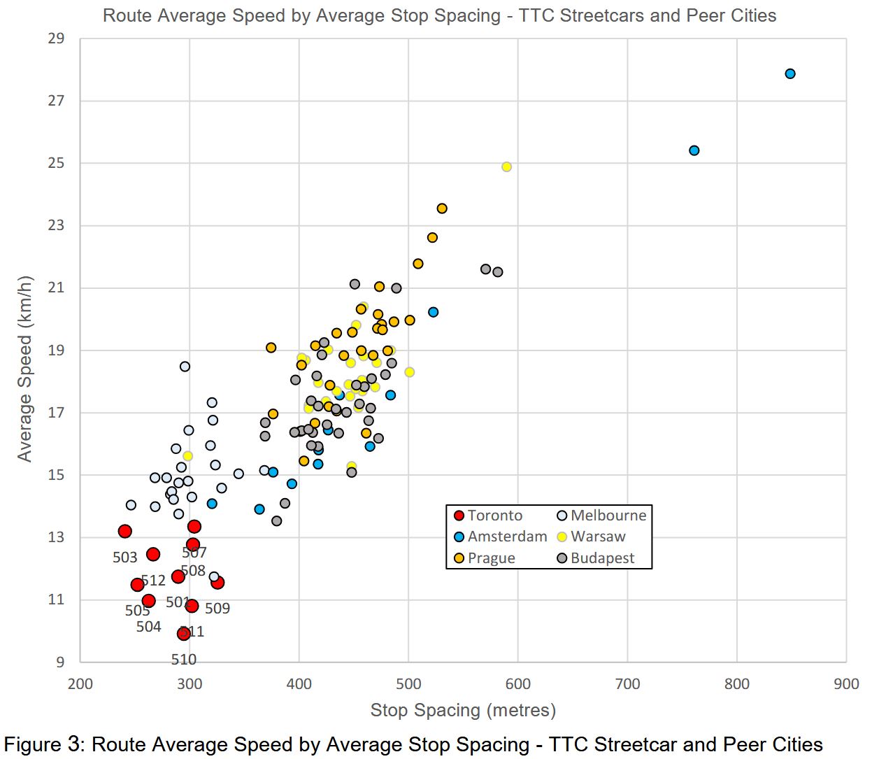
A chart accompanying the TTC report shows the speed and stop spacing values for several transit systems. Toronto is down in the left bottom corner with the closes stops and the slowest speed. However, Melbourne’s trams are in the same range as Toronto for stop spacing, but they operate faster. Nowhere does the TTC examine what differences might apply to Melbourne lines, nor for the other systems that are both faster and with wider stop spacing.
Although there are some outliers, the bulk of the data points are in the 400-500m range, but this does not examine route characteristics. The original study of slow Melbourne streetcars by Dr. Jan Scheurer commented about Toronto that “CBD-typical speeds seem to extend across the entire city” [p. 8]. Riders who sit in traffic jams on King or Queen Street West, or on Queen Street in the Beach are quite familiar with this problem. Toronto streetcars do not emerge from the core to fly into nearby suburbs.
There is also the issue that Toronto streetcars used to move faster both with the CLRV fleet and the PCCs that preceded them. Something beyond stop spacing is at work even on routes with dedicates rights-of-way. It is easy to go after stops as a source of delay because this would not require an examination of TTC operating practices and the City’s lack of aggressive transit signal priority. Indeed, during the last round of major works on St. Clair, it was discovered that TSP was not actually working in many locations.
For the sake of argument, assume that the delays to TTC streetcars come from closely spaced stops. Any rider knows that there are other factors including slow operation through junctions, traffic signals that do not give streetcars priority and congestion both in the core and the outer parts of many routes.
The premise is that fewer stops will speed service benefiting those already on streetcars at the expense of those who have to walk further to a stop. This is a bogus argument regardless of stop spacing. There will almost always be more riders passing any individual stop who would “benefit” from its elimination than riders who use the stop. The same argument could be made for some subway stations.
Here are the TTC’s Board-approved stop spacing standards. The target range of 300-400m for local surface routes implies an average stop spacing of 350m giving some leeway to adjust to conditions.
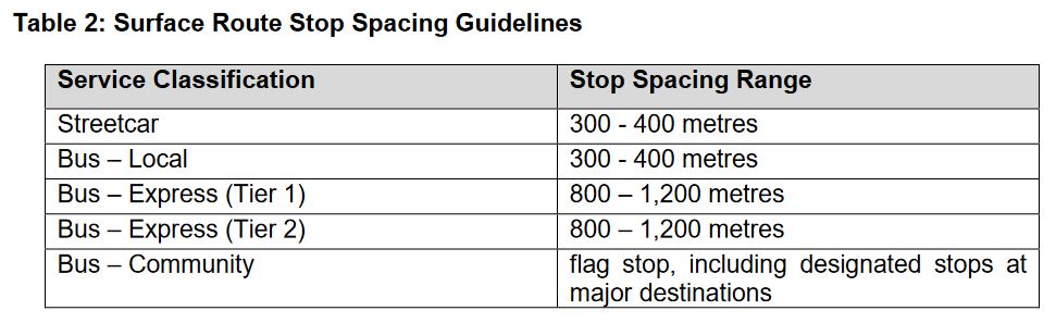
(To give readers a sense of distance, a subway station platform is about 150m long, and so a 300m walk is from one end of a station platform to the other and return.)
Streetcar route averages lie roughly in the 250m-325m range below the standard’s midpoint of 350m. Some stop trimming has already occurred to eliminate very closely spaced stops.
Note that 508 Lake Shore shows the same average as 507 Long Branch even though the 508 travels into the core. The reason is that the stop spacing between Humber Loop and Roncesvalles is quite wide, and this offsets the closer spacing on King Street in the average.
| Route | Termini | Stop Spacing (m) |
|---|---|---|
| 501 Queen | Neville-Roncesvalles (*) | 241 |
| Roncesvalles-Humber | 448 | |
| 503 Kingston Road | Victoria Park-York | 284 |
| 504 King | Dundas West Stn-Distillery (*) | 283 |
| Dufferin Loop-Broadview Stn (*) | 280 | |
| 505 Dundas | Dundas West Stn-Broadview Stn (*) | 278 |
| 506 Carlton | High Park-Main Station (*) | 260 |
| 507 Long Branch | Long Branch Loop-Humber Loop | 312 |
| 508 Lake Shore | Long Branch Loop-Distillery | 306 |
| 509 Harbourfront | Exhibition-Union Station | 373 |
| 510 Spadina | Spadina Station-Queens Quay | 293 |
| 511 Bathurst | Bathurst Station-Exhibition Loop | 328 |
| 512 St. Clair | Gunns Loop-St. Clair Station | 270 |
Notes:
- 501 Queen stop data are taken from the pre-Ontario Line construction with service running directly across Queen from Church to York.
- Stops near Dundas West and Broadview Stations that are used primarily by overnight services have not been included in the stop counts for 504 King and 505 Dundas.
- 506 Carlton stop data are taken from the through route before construction diversion around Bay & College.
Some Basic Math
If one wants to achieve a major saving from stop time, many stops have to be cut on a route. One or two will annoy their regular users, but the change in travel time, if any, will be quite small and disappear into the background noise of other variations.
The basic calculation is simple: if a route now has an average spacing of 300m, and you want to raise this to 400m, then one quarter of the stops must vanish. The bigger the change in stop spacing, the more stops must be eliminated.
The numbers of stops for various spacings per 1km are shown below:
- 250m: 4.0
- 300m: 3.3
- 350m: 2.9
- 400m: 2.5
- 450m: 2.2
- 500m: 2.0
With the TTC standard of 300-400m, 350m falls half way along, or 2.9 stops/km. Just to bring routes now at a 250m spacing (4.0/km) to that level would require a reduction of about 1.1 stop/km, or about 12 stops each way on a route the length of 505 Dundas (11km).
If the goal is to move to a 400-500m standard, this means the new target average would be 450m. A route whose average is now 250m would lose almost half its stops. This would be extremely difficult as routes do not have that many “unimportant” closely-space stops to begin with.
The effect would not be on a few riders at a few minor stops, but on many riders all along the routes. They would face extra walking distance lengthening overall travel times, not to mention accessibility issues for those with mobility challenges.
A simple, but important, number is not the space between adjacent stops, but the space that would result if any stop were removed. (In other words, the space between stop N and stop N±2.) In some cases, the existing TTC standard would still be met, but in many the gap between stops would be well outside the standard. For example, if three stops are each 300m apart, getting rid of the middle one creates a 600m gap, well above the standard.
Stops cannot simply be re-spaced to maintain uniformity or iron out problems with stop elimination. For pedestrian safety, stops are almost always at signaled intersections or at least at pedestrian crosswalks so that riders can cross safely to/from stops on the opposite side of the street. The existing street layout, signal patterns and major destinations such as transfer points determine where stops might go. Toronto, unlike Manhattan, does not have a repeating grid as a base for designing standards.
In the sections that follow, I will turn to a few sample routes. There are occasional closely-spaced stops, some with good reason, but not many are ripe for plucking without adopting a considerable increase in the standard and substantial cut to the number of stops. This should be a conscious policy debate, not a change buried in a wider review of Service Standards without a clear indication of the effects on routes across the city.
Removing Stops: Introduction
In this section, I review a few routes to show the current stop spacing and which stops would likely to be cut if there were a stronger alignment to the 300-400m spacing standard. One could push for a large standard such as 400-500m, but this would involve cuts of more important stops. This would be constrained by the street layout, traffic signals and transfer points. Those who aspire to make streetcars more “efficient” by cutting stops would do well to consider the real world city and route layout. Assuming that faster travel time, if any, is worth the extra access time to and from stops is simplistic, bad planning.
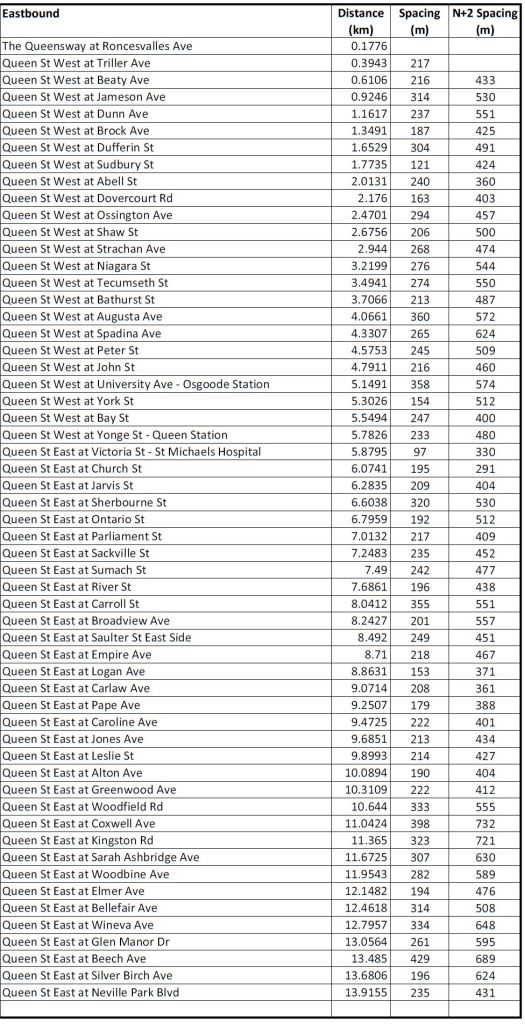
505 Dundas
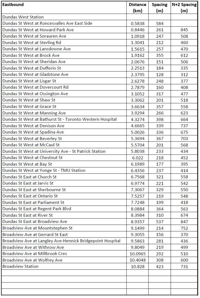
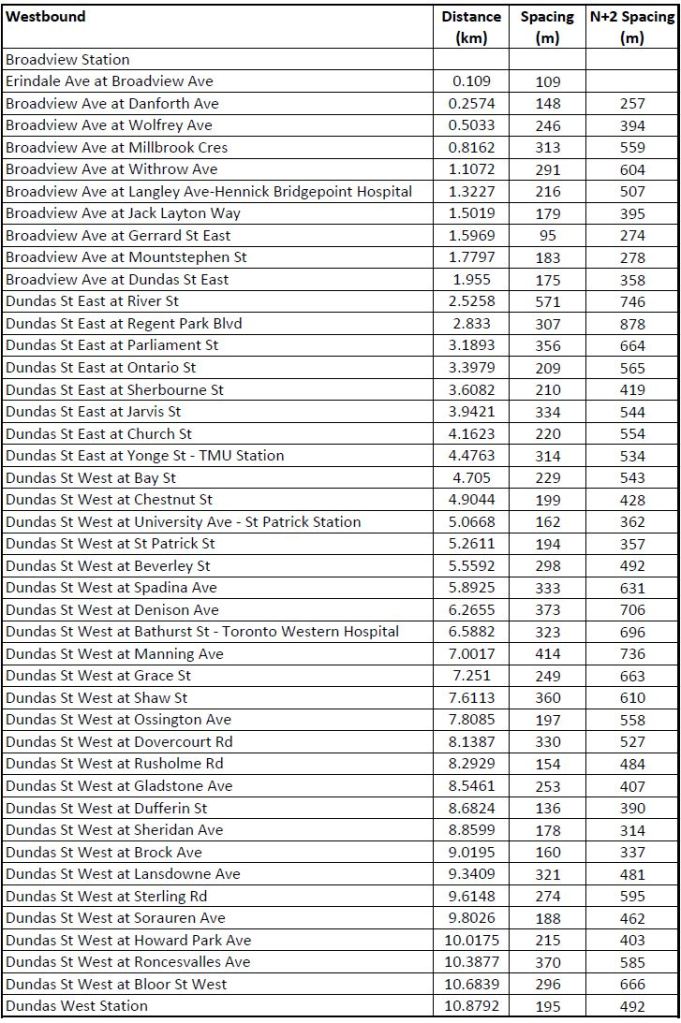
The tables below show the eastbound and westbound stop lists for 505 Dundas together with the elapsed distance along the route, the space between adjacent stops, and the “N+2” spacing showing the gap that would be created by removing each stop. First cut candidates for removal are those locations where the N+2 value remains within the 300-400m standard, although these are subject to local considerations such as the density of traffic generators and connections to other routes.
For example, there is a cluster of stops between Brock and Dovercourt where individual locations, but not all of them, could be dropped while staying within the standard. Dufferin is a transfer point and obviously must remain. Here are the effects of various possible removals:
- Sheridan: Leaves a gap of 355m EB from Brock to Dufferin, 337m WB.
- Gladstone: Leaves a gap of 377m EB from Dufferin to Lisgar, 390m WB from Rushholme to Dufferin.
- Chestnut: Leaves a gap of 395m EB from University to Bay, 362m WB
- Mountstephen: Leaves a gap of 370m NB from Dundas to Gerrard, 358m SB. [*]
- Erindale or Danforth SB: Although these are closely spaced, arguments for both of them can be made, especially considering the stop at Danforth is used by buses even if streetcars bypass it in peak periods. [*]
- Jack Layton Way SB: This stop is very close to Gerrard, but in winter is a better stop for access to Bridgepoint Hospital via a clear snow path. The “official” Bridgepoint stop at Langley requires use of a path through the park that is not reliably cleared.
- [*] Full disclosure: These stops are regularly used by me, among many others.
- This analysis does not take into account stop usage.
If all of these were removed (and I am not suggesting that they would be), that would be a total of about 10 stops over a routes that is about 22km long, or about 1/8 of the total stops on the route. Although this would get rid of the “worst offenders”, the resulting average over the route would only move from 278m to 309m EB and 253m to 294m WB. Stop spacing on most of the route would not change.
A higher target average would require more removals, and this would be challenging in some areas given the importance of stops that would remain after the first round of cuts.
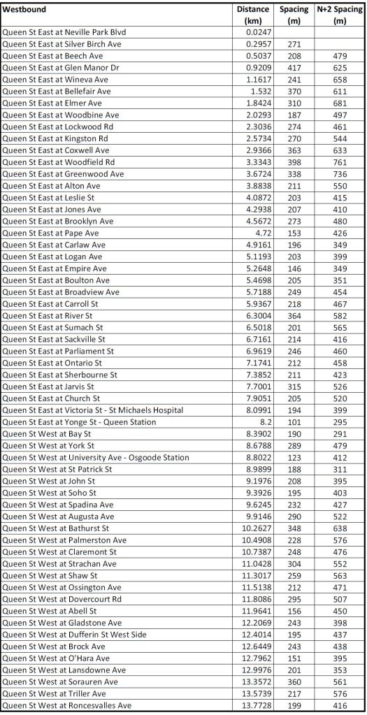
501 Queen
These tables of stop spacing on Queen cover the route from Roncesvalles to Neville. West of Roncesvalles on The Queensway, stops are already further apart, and given the physical infrastructure would be extremely difficult to move. The major problem on that section of the route is the absence of transit priority at signals, farside stops with the “double stop” pattern seen on other routes, and operational restrictions on speed crossing intersections.
Queen has already been through some stop consolidation, and few locations have an “N+2” value below 400m indicating possible stop elimination under the current standard. Possible candidates within that constraint are:
- Abell: Leaves a gap of 403m EB from Sudbury/Gladstone to Dovercourt, 398m WB.
- York: This stop has already been moved in the OL diversion and is now further from University. Whether it will be reinstated on Queen in the normal route remains to be seen.
- Bay: This stop was dropped on the OL diversion, but given that it serves City Hall and is a transfer point to the 19 Bay bus, permanent removal is unlikely.
- Victoria: This stop is very close to Yonge, but it is also the stop for St. Michael’s Hospital. On the OL diversion route it is not used on Richmond or Adelaide.
- The stops at Empire and at Saulter/Bolton are likely to be consolidated to serve the Ontario Line’s Leslieville Station which lies between them.
- Although Logan and Pape are close to Carlaw (a transfer point to 72 Pape), dropping either of them would be borderline considering the level of demand they serve.
Overall, this would lead to about four stops removed each way depending on assumptions. This would raise the average eastbound spacing from 245m to 264m, and westbound from 241m to 270m.
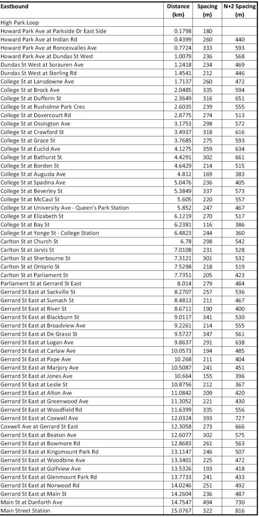
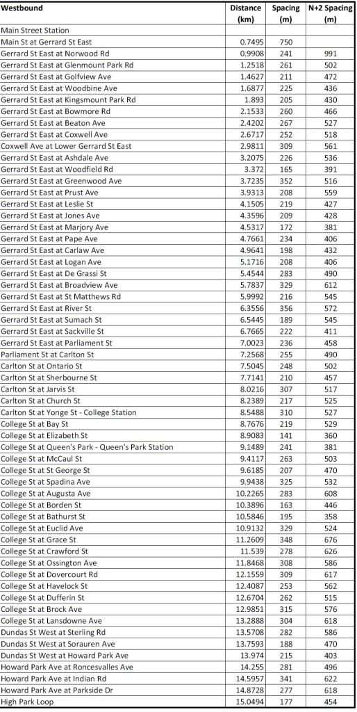
506 Carlton
Few stops on 506 Carlton could be removed without creating a gap larger than 400m. Possible candidates are:
- Borden: Leaves a gap of 383m EB from Bathurst to Augusta, 358m WB.
- Elizabeth: Leaves a gap of 386m EB from University to Bay, 381m WB. (This stop serves the east end of the Toronto General Hospital block and Women’s College Hospital.) Although Bay is close to Yonge, it is a transfer point.
- Marjory: Leaves a gap of 396m EB from Pape to Jones, 406m WB.
With only three candidate stops each way, the change in the routes average spacing would be minimal. Eastbound would rise from 260m to 274m, and westbound from 264m to 279m.
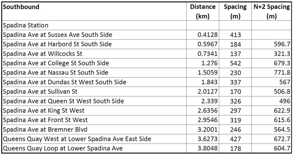
510 Spadina
During the design of 510 Spadina 30 years ago, there was a robust debate about whether its purpose was to speed people from the Bloor subway south to proposed developments in the rail lands, or to serve local neighbourhoods along the line. The result was that stops at Sussex, Willcocks, Nassau and Sullivan were placed between the main crossing streets.
Ever since, they have been the target of those who argue that Spadina has too many stops although the major problems on Spadina arise from a combination of farside stop placement, traffic signal delays, and TTC operating projects at junctions.
Without changing the Service Standards, few changes can be made on Spadina.
- Removing Sussex would produce a 597m gap SB from Spadina Station to Harbord, and 514m NB.
- Removing Willcocks would produce a a 679m gap SB from Harbord to College, and a 646m gap NB.
- Removing Nassau would produce a 567m gap SB from College to Dundas, and a 594m gap NB.
- Removing Sullivan would produce a 496m gap SB from Dundas to Queen, and a 488m gap NB.
The only candidate within the 400m standard is northbound at Richmond where the resulting northbound gap from King to Queen would be 392m. Southbound, only a single stop serves both Queen and Richmond.
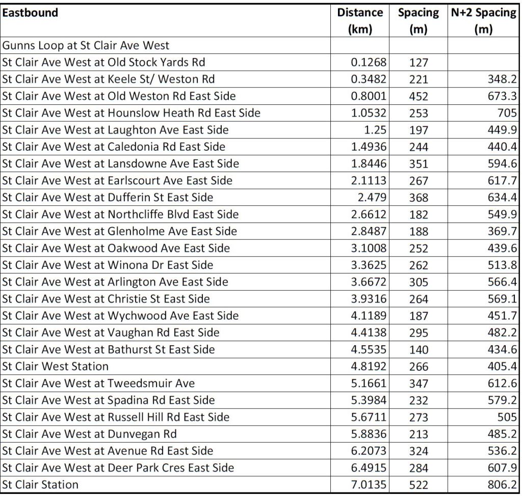
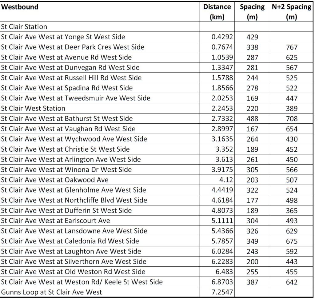
512 St. Clair
On St. Clair, there are only a few candidates where the 400m maximum could be preserved:
- Although the stops at Keele and Old Weston are close together, they are separated by a rail underpass and both of them are transfer points.
- There are two intermediate stops between Old Weston and Caledonia (at Hounslow Heath/Silverthorn and at Laughton), but removing either of them would create gaps over 400m.
- Removing the stop at Northcliffe would create a gap of 370m EB to Glenholme, and 365m WB.
- The stops eastbound from Christie to Bathurst are close together, but removing any of them creates a gap over 400m.
- The stop at Bathurst eastbound at the top of the ramp into St. Clair West Station is very close to the eastbound stop farside at Vaughan Road, but it is also a transfer point to the 7 Bathurst bus. If it were removed, passengers making the connection would have to walk west to Vaughan to access the eastbound stop.
- Removing the stop at Tweedsmuir would create a gap between St. Clair West Station and Spadina, but the length is uncertain as the GTFS data give quite different distances between the station and Tweedsmuir (347m EB, 220m WB). The actual distance from Spadina to the station entrance is less than 400m. Removing Tweedsmuir would also affect the 33 Forest Hill bus.
- The stop at Dunvegan (Timothy Eaton Church) has been touted for removal, but this would create a gap of 536m EB from Russell Hill to Avenue Road, and 525m WB.
The existing average stop spacing over the route is 270m eastbound and 264m westbound. Removing three stops each way would increase these values to 305m and 299m respectively.

Moaz: While this isn’t an apples to apples comparison one might ask if the advocates who would remove streetcar stops due to close spacing would advocate to remove subway stops based on the same argument, and which ones they would remove.
Moaz: Perhaps we need a Winter Stops network that better aligns with reliable snow clearance.
LikeLike
I like that comparison chart as it shows well how stop spacing really isn’t the problem. Speeds in Melbourne are faster with the same spacing. Then speeds in Prague are also much faster with wider spacing, but you look at the axis and it’s only 100 metres wider. The “if only we had wider stop spacing like they do in Europe” crowd would see that if we went to that spacing we would actually cut very few stops in the system. Stop spacing isn’t the problem with speed. Full stop. Period. The data proves it.
LikeLike
It bugs me a little that the South Kingsway stop for the 501 Queen was not removed when they removed the original stairway built in the 1950s, and replaced it with a stop next to the northeast cloverleaf at The Queensway & South Kingsway. It is 200m to the streetcar stop at The Queensway & Windermere.
LikeLike
You have overlooked a serious problem which is very obvious to both streetcar-drivers and regular passengers:- left-turns by motor-vehicles. Toronto has quite high motor-vehicle volumes and many of these motor-vehicles make left-turns which in turn block streetcar-tracks and force trams to wait, and wait, and wait,……..and wait (etc) and this hugely slows down the trams. The conceptually-simple solution is to widen a roadway to five lanes from four to allow a fifth left-turn lane between the tracks so trams can proceed without waiting for left-turning motor-vehicles but most streets in Toronto are too narrow to allow that solution. The simplest solution is to replace the trams with buses and this actually works very well in almost all cases but it is not a politically-correct solution so it won’t happen. Trams are simply incompatible with high volumes of motor-vehicle traffic and the best alternative in a big city is to replace the trams with more subways and buses but of course Toronto seems to have chronic ideological problems with subways so guess what?:- Toronto’s transit problems will continue unabated forever-more. For most us though it’s just better to move somewhere else to another smaller city which does not insist on choking itself with outmoded modes of public-transit. However in Toronto if you have nothing to do and plenty of time in which to do it then a very good place to do it is sitting on a slow streetcar to nowhere and be a student of the contemporary scene while observing the passing parade. There is basically no solution in Toronto to this problem:- Toronto politicians refuse to make the big investments needed to solve this problem and for most of us the most practical response is to move somewhere else where slow trams are not a problem.
Steve: I didn’t overlook this. The article was about stop spacing and issues like lane restrictions are covered elsewhere. The concept of a road widening is impossible in almost all locations without demolishing buildings. I agree it’s better you move elsewhere.
LikeLike
Thank you for your informative articles and keeping TTC accountable. Maybe that’s a wishful thought, they could care less…with respect to spacing, what annoys me most is the spacing between streetcars, not stops. Don’t know how many times I’ve seen three in a row followed by an extended gap with no service. On average they may boast there’s a car every ten minutes but in practice it can be every half hour. They’re also rude – on St. Clair at Yonge near where I live I have seen countless times when the westbound streetcar pulls away just as the north-south traffic light turns green so pedestrians can get to the platform. It would cost him 10 seconds to let the passengers board. Even if they make it before the streetcar moves, the doors lock.
With respect to Melbourne, the CBD is a pedestrian zone and streetcars are frequent and free. They run in a loop around the core. Definitely the better way to get around. We could easily do the same by using dedicated lanes on Richmond and Adelaide, they are both wide one ways and only a block from the retail strips of King and Queen.
Thank you for the good work.
Regards, Marty
Steve: Yes, definitely, bunching is a far greater problem than stop spacing. The time lost to excessive waits plus the crowding this causes is far worse than the supposed time savings of dropping a few stops enroute.
LikeLiked by 1 person
Slow door operations is the silent killer. Imagine if the eggheads at the TTC’s Department of Passenger Safety decided “in the name of safety” to increase the door cycle times on buses from their current speed to 10 seconds from fully closed to fully open to fully closed.
LikeLiked by 1 person
This does beg the question a little bit about whether 300-400m is the right interval in all situations though? If we admit that the longer spacing on the Queensway is appropriate (which of course it is) then might there not be other circumstances where that’s also the case? Should less-dense areas with lower traffic volumes and more widely spaced cross routes such as the west end of St Clair be subject to the same spacing as Queen St downtown?
Overall though it’s hard to argue with the premise that this discussion is a bit of a distraction, stop-spacing is not even top 5 in issues which cause slow streetcars (in no particular order the following are certainly more impactful: mixed-traffic running in congestion, lack of signal priority, lack of traffic enforcement, overly conservative operator speeds, track maintenance, etc)
You’ll never convince me though that the Sussex Ave stop shouldn’t be removed (and through-traffic banned and replaced with a pedestrian signal).
Steve: My issue is that there are far fewer places like Sussex, where one can make a strong argument for removing a stop, than stop-removal advocates like to imply. There simply isn’t much low hanging fruit. An important distinction between The Queensway and St. Clair West is that there is likely to be an increase in density on St. Clair (developments are already proposed although dormant in the current climate) whereas the south end of High Park is quite another matter.
But it gives so-called advocates something to talk about, and management can blame slow operations on locals who just won’t give up their precious stops, rather than looking at their own bad line management and bad operating practices.
LikeLike
It’s pretty clear that stoplight proliferation, especially on 3 way intersections, and minor cross streets needs to be investigated…along with the extension of yellow lights for pedestrians at almost all intersections…
Most of the three way can be removed by conversion to right turn only, and removal of cross streets can likely be done as well (potentially retaining bus routes with bus only signals, that don’t change unless a bus is present).
Yellow extension issues should be confronted aggressively with pedestrian islands, and expansion of streetcar stops where possible to perform that service as well as purpose built islands at other locations.
On most of the routes the number of lights/km has doubled since the 90s. Which is nuts. It also is continuing to get worse…and new lights should only go in after alternatives have been explored.
We also now have issues with the red lanes, where people are making lefts or straights through alternating slow/fast lanes with bad visibility and getting t-boned. If this isn’t managed well new lights will spring up in these locations as well.
LikeLiked by 1 person
Hello Steve,
Thanks for the great detailed analysis of the stop spacing. Just to note, TTC in the past month or so moved the westbound 501 stop at Dufferin from farside to nearside underneath the rail bridge. Now the Gladstone stop is incredibly close to the Dufferin stop. It looks to be a permanent change with a new pole installed and stop removal signage on the old far side stop.
Steve: Thanks for the update. I will have to check to see if this is reflected in the current stop spacings in the schedules.
LikeLike
I know this article’s about streetcar stops, but one stop pair that’s always bugged me is the 23 Dawes stops northbound on Dawes at Ferris, and westbound on Ferris immediately after making the left. These are both 2 lane roads (plus bike lanes on Dawes) with, from what I’ve seen at various times of the day, both weekdays and weekends, usually about 0-2 people using each stop. So it’s not even like the near and farside stops eastbound at Markham and Lawrence, where you’d have to cross 6 lanes to get across Markham (2 southbound lanes and 2 through lanes plus left and right turn lanes northbound), and with a decent amount of activity at both stops.
LikeLike
Forgot to say in my last comment, a decent number of times, the bus would stop 3 times in less than 100m: once at the nearside stop, again to wait for a gap in traffic to make the left, and once more to serve the farside stop.
LikeLike
I am from Europe, and I’ll be blunt here. The distance between some stops on several streetcars line is ridiculous and some cleaning up and consolidation of stops is dramatically needed.
It’s called transit optimization to serve riders getting to their destination more reliably.
When world class services in major cities are 400-500 meters, then this needs to become our new standard for Toronto.
There is no such thing as “Toronto is different” justifying the need for more stops for any reasons whatsoever. We are not special.
I’d bet my 2 legs that most of the stops planning date back from the early 20th century when life and transit was drastically different.
TTC needs to get their things together and learn from what works, not just operating because that’s how it’s “always been done” (which it’s clearly not working).
Steve: Maybe you would be a tad less pompous without hiding behind a pseudonym.
Lots of things are “world class” depending on what direction one might look. We could also look at transit priority and good operating practices, but it’s easier to distract people with the idea that walking further to stops is “good for you”. One thing at least some world class transit cities do is to stomp hard on the idea that roads are primarily for cars, but that sort of change requires a political commitment far more difficult to muster than changing stop spacing.
For the record, Toronto’s Complete Streets Guide says:
It does not take long exploring research papers online to see there is a consensus that ridership tends to fall off if the walking distance to a local bus stop is over 400m, assuming level ground. That 400m includes access from the neighbourhood around a stop out to the transit route and then along it to the stop. The further apart stops are, the more of the neighbourhood will lie beyond 400m from a stop. If you are designing an express route, different rules apply because you are actually offering a faster trip to offset the access time penalty.
Here’s Human Transit’s Jarrett Walker on the subject:
One reason I published details of existing route layouts was to show exactly what things look like today. If you’re so keen on a 400-500m spacing, please pick a major route and say which stops would stay and which will go. It’s easy to find a few howlers on each route, but then it gets much harder, especially if you have to preserve stops at transfer points and major trip generators. On Queen you would have to get rid of almost half of the stops.
I look forward to your brief career “serving” the public.
LikeLike
Why don’t we just pick one as a pilot project and only have stops where there are connecting bus routes? Like 510: Spadina Station – Harbord – College – Dundas – Queen – King or 512: St Clair Station – Avenue Rd – Spadina – St Clair West Station – Vaughn – Christie – Oakwood – Dufferin – Lansdowne -Caledonia – Old Weston – Keele – Gunns Loop. There will be more of an impact on the routes with private rights of way.
Steve: And watch riders be extremely pissed off because they have to walk further, and the remaining stops will be more crowded and take longer to load.
And of course those poor folks living between King and Queens Quay are just goona have to walk.
LikeLike
This is pretty square with my experience on Spadina. The number of stops pales in comparison to how slow all the far-side stops are. The near-side stops at Sullivan and King SB are 30-60 seconds faster than the far-side stops elsewhere on the route. NB has far-side stops on the whole stretch NB from QQ to College that I’m on, it’s a slog. Even the left turn times are only 10-15 seconds, it’s not a huge deal and people would often be getting off the train while the cars are left turning.
LikeLike
I don’t understand why Steve is so against walking. God gave us two legs precisely to walk. If you are unable to walk a few metres and I totally understand that this may be due to old age and/or health problems, then you should really be on WheelTrans. Our tax dollars are funding WheelTrans for precisely this very reason, take advantage of the service that is available to you. You are welcome to take regular transit as well but don’t slow everyone else down by expecting a stop every 100m.
Steve: Listen you turd, the TTC is trying to get people OFF of Wheel-Trans to save on costs and have we doddering old fools use the regular system. That’s why they’re spending millions making stations accessible. To turn around and make it harder to walk to local stops runs directly opposite to that scheme. I don’t expect a stop every 100m, but equally don’t want transit to be less convenient for everyone because somebody is peddling the idea that stripping stops out of the system will turn streetcars into speed demons.
LikeLike
The TTC graph referenced above was either accidentally made to be misleading, or deliberately and disingenuously so.
The origin of both axes is NOT zero. This makes the TTC’s performance look much more pathetic than it actually is, in comparison. For what it’s worth, if you set up the axis properly so that both stop spacing and speed start at zero, the origin (0,0 point) would be off just in the green part of Steve’s page, and somewhere about the second paragraph below the graph, the one that starts “The premise is….”
If the vertical axis (speed) did start at zero, there would be a vertical blank area under the TTC points, about the same vertical distance as in which most of the speeds fall into on the graph.
In other words, most of the speeds on the graph are between 10 and 20 km/h. Starting the vertical axis at 9 km/h just makes it look like the TTC are vastly worse, in comparison, than they really are. If it started at 0 km/h, then we’d see a group of speeds clustered over a range but nowhere close to zero (despite the TTC’s efforts).
Bad graph. No biscuit.
Another thing to keep in mind that population density and street layouts are NOT the same between the various cities. It seems that Melbourne may share Toronto’s grid street pattern, but without firsthand experience, it’s dangerous to generalize. The street layout in the European cities is bound to be historical, and likely radial. This will impact desirable stop spacing based on how cross streets are laid out, as well as how far apart parallel routes might be.
The linked article on Melbourne’s tram speeds does not really seem to get into these considerations.
Neither do some of the troll-like commenters above.
LikeLike
I think you need to redo the calculations on the 505 line. The N+2 for the Danforth at Broadview stop does not make sense as removing Erindale has no impact on that stop since it’s closer to Broadview Station then the Erindale stop. Numbers for removing both of those stations need to be looked at in comparison to Broadview Station not each other.
Not sure also how the Erindale stop is 109 meters from Broadview. Is that walking distance to the subway entrance? Cause it’s not the route length from the streetcar bay to the stop as that it maybe 50 metres. And if it’s waking distance than the Danforth stop should be calculated as walking distance to Broadview not to Erindale as any rider would walk to the station over going to Erindale.
Steve: Sorry about that. The numbers are the TTC’s from their GTFS schedules and measure distance travelled by vehicles. I agree that for terminal loops with nearby stops I should have taken actual walking distances into account. Broadview Station is unusual in having two stops like that (one of which is not always in service, by the way).
LikeLike
Thanks for this analysis, Steve. My impression is that much of the discussion around speeding up vehicle times comes in part from the experience on the new Finch LRT, which I appreciate has different contours from the downtown scenarios mentioned here.
Do you see any possibility of some sort of rush hour-only express option on the Finch LRT? Applying a standard where it only stops during rush hour at streets where it intersects with another bus would, from what I can tell, bring it down to 10 stops between Humber and Finch West from 17.
Steve: I’m not sure, and would want to see detailed loading data to illustrate if some stops really are so underused that they could be dropped in peak times. This actually seems counterproductive, and if TTC, Metrolinx, City Transportation and Mosaic hadn’t done such an incompetent job of setting up this operation in the first place, we might not even be having this conversation.
I have little doubt that the issue and solutions are more complicated than that, but I raise it as a type of possibility to consider given the urgency to restore public faith in what was billed as a rapid-transit line. Perhaps they could accompany that with local bus service stopping more frequently during those times? I realize that’s an imperfect and not the most cost-effective solution, but it seems important for the system to address the disappointment that the Finch LRT isn’t living up to what was promised. By taking action on it early, it’d also help deal with the difficulty of removing legacy service that people have come to expect, unlike the situation with the streetcars downtown. Just a thought!
Steve: The problem with running a bus in parallel is that would “prove” that the LRT was a waste in the first place. The problem is to make the LRT faster and more reliable, not to abandon it to some sort of half-assed operation that gives the term LRT a permanent black eye in Toronto.
LikeLike
I have to think the Flexitys and their longer dwell times have accelerated the calls for stop removal / consolidation. Thinking e.g. about the section of Queen between the Don River and Greenwood where the stops are generally 200 m apart (give or take). That wasn’t too bad when the route ran with ALRVs (CLRVs) and the doors were quick when there were only one or two passengers. You notice it more with the doors of the Flexitys. (Oh and then you get to Russell, where the stop spacing is replaced by crawling through special work and multiple facing-point switches.)
This isn’t to say that they should be eliminated (and if anything walking distance is more of an issue east of Broadview where the east-west routes are spaced farther apart). More that it is another example of where TTC policies or practices (door times) have reduced speeds compared to 20 or 30 years ago, so it doesn’t surprise me that people start asking “do we really need to stop again when we just stopped two blocks ago”.
(200 m also tends to show up in urban design guides as a recommended spacing between controlled pedestrian crossings.)
re: The Sussex-Harbord-Willcocks “trio”. If you were looking to consolidate / remove stops, and you were looking to even out stop spacing or get closer to “standard”, the stop you would actually remove is Harbord… but of course you would not do that.
Steve: One reason I included the detailed table of stop spacing info was to force a discussion of what would work as a removal and what wouldn’t. It’s not as simple as it’s made out.
LikeLike
Excellent discussion on streetcar stop spacing. Close stops are ideal but certain stops are just way too close to each other. The Jack Layton Way stop is way too close to the stop at Gerrard, we should keep one or the other but not both. Similarly, Broadview is way too close to Munro St to warrant a stop at both, we should keep one stop or the other but not both. Also, the Aga Khan stop way to close to the Don Mills stop, we should keep one or the other but not both.
Steve: Are you aware that the stop at Munro and Dundas was removed some time ago?
The Aga Khan stop exists in part because the option of walking east to Wynford through the DVP interchange is unsafe.
LikeLike
The front doors on buses open/close in about 2 seconds. The Flexity doors in about 3 seconds when they were delivered. TTC DoPS decreed the time be increased to 5 seconds on the Flexitys.
Every time a person walks up to the door and pushes the button it introduces a 15 second delay or more.
This is how TTC management thinks an effective system should be run.
LikeLiked by 1 person
No, I was not but thanks for informing me. It was always very annoying that the streetcars stopped at Munro St and this was a low ridership stop too.
Me: The Aga Khan stop is way too close to the Don Mills stop, we should keep one or the other but not both.
Steve: The Aga Khan stop exists in part because the option of walking east to Wynford through the DVP interchange is unsafe.
There are sidewalks on both sides of the street, just walk to a pedestrian crossing and wait for your signal to cross. There are hundreds of dangerous crossings in Toronto, are we going to put a streetcar stop everywhere to help people cross safely? The greater danger is from boarding and disembarking streetcars in mixed traffic.
Steve: The last time I looked the Aga Khan stop was not in mixed traffic. I’m explaining one of the reasons the stop is there, not trying to justify every location in Toronto on that basis.
LikeLike
The suggestion about only having stops at connecting buses:
When we moved to Toronto (Thistletown area) in 1959 our only bus was the Woodbridge line, which ran from, IIRC, Runnymede loop to Boyd conservation area, just beyond Woodbridge. There were no connecting buses north of Wilson and Weston Road.
(Also, the end of the line was in Zone 5 or 6.)
Our other claim was that the bus ran every hour and a half in rush hours, less frequently the rest of the day.
Steve: Yes, the idea of only stopping at transfer points fails in many parts of the city. The issue is “where are people and where do they want to go”. They are not organized in convenient clumps every 600m or so to make bus and streetcar operations simpler.
LikeLike
On King West at Dufferin this past week, I noticed a 504 operator turn off the door buttons once the doors were closed, preventing one of these delays. The light had not yet turned green, but the operator was clearly getting ready and ensuring they could move. Is some door sanity starting to appear, I wonder?
Steve: There are two types of delay in this situation. One is, as you described, sitting at a traffic signal about to change, and turning off the door buttons to allow a prompt departure. The other is at a busy stop such as King & Yonge or University where an unending stream of transfer passengers arrives from the subway preventing the doors from closing in the first place.
LikeLike
The 501 westbound stop at Dufferin has indeed been moved to nearside. This seems to at least partially be due to demolition (with attendant hoarding) and perhaps upcoming construction at northeast corner of Queen and Noble, next to the former farside stop location.
I don’t know if it’s intended to be permanent. I believe the farside stop dated back to before the Dufferin gap was tunnelled through, so maybe there was previously a desire to keep loading streetcars out of the way of cars turning from westbound Queen onto southbound Dufferin, and it was not moved once Dufferin was tunnelled through and the left turn became less crucial.
Steve: Yes, the stop placement dates from before Dufferin was punched through under the railway. Similarly stops at Gladstone date from the old 29 Dufferin bus route and the former location of the transfer point.
Another thing that’s changed since the data used for this analysis is that the 501 eastbound stop at Roncesvalles moved farside in the KQQR rebuild. It’s a much better stop now. But now it’s 120 metres to the Triller stop. But the stop at Triller serves a major apartment building and there’s considerable slope down to Roncesvalles, so elimination is undesirable. Most that comes to my mind is moving the Triller eastbound stop to farside (Triller has a PXO so less risk of a double stop), but that’s only a 40-50 metre adjustment.
Steve: I will update the 501 stop list with revised spacings for the west end of the route. BTW, the stop at Abell will be removed on May 3.
To me the worst offender is westbound 504 at Jefferson and then at Joe Shuster. That’s under 100 metres between stops. Jefferson is effectively a farside stop for Atlantic Avenue, where a nearside stop is not used due to slope coming out of the rail underpass, but it’s unnecessarily far from Atlantic and should be moved back closer to the Atlantic intersection if it is to be kept. It is a difficult situation though – both Atlantic and Joe Shuster have destinations and neither is obvious to really eliminate. (FWIW, I recall there was formerly a stop at Fraser Avenue that was moved to Joe Shuster when the signal was installed there.)
Steve: Yes, the Fraser stop was moved.
The TTC is generally stuck in a position where Toronto’s poor walkability (narrow sidewalks, dangerous crossings, bumpy roads) and lazy traffic signalling make stop elimination undesirable because a 3 minute walk can be a major hassle. There is a similarity to how a lot of traffic signals are added due to unsafe driving (see the traffic light at Queen and Sackville which is a _direct_ result of a car driver killing a pedestrian in a PXO — because just some flashing lights and a marked crosswalk is not enough to get attention of Toronto drivers), and also to pedestrians beginning to cross on flashing hand (taking away chances for cars to turn and perhaps clear the intersection for transit). Everyone’s at war with each other on Toronto’s streets, and no one is winning.
Steve: In defense of pedestrians, there are intersections where the flashing hand appears very soon after the walk signal, and there is a very long time before the traffic signal actually changes. These are locations where turning traffic is favoured over pedestrians, even when they are quite numerous. Pedestrians are understandably annoyed, especially if the short walk cycle is a change from how the signals have worked for years.
If the city’s Transportation Services could be brought onboard, we could do signalling changes that create better stops without pouring much concrete or taking away car lanes as follows:
Better, faster, more comfortable farside stops on routes without right-of-way. The stop is immediately after an intersection (back of streetcar would be at the pedestrian crossing). The traffic signals get a streetcar detector and the behaviour is as follows:
When a streetcar is detected (preferably up to 50 m or 100 m from the intersection), the signal is kept green, preferably even with a left-turn green at intersections where there is likely a significant amount of these. The light turns yellow as streetcar nears intersection and to red as streetcar enters it, but a streetcar signal keeps a white bar to allow the streetcar in. Now the cross street gets a green (or the opposite direction gets a left-turn arrow) while the streetcar loads without blocking the green, loading is more easier and faster without any cars in the curb lane, and the streetcar can depart as soon as doors close. _Everyone_ benefits.
But alas, today’s Transportation Services prefers to hang a Christmas tree of general, transit, and bicycle signals, each doubled for safety, but getting a streetcar detection and working priority you might as well be speaking Greek…
Steve: The double signals, alas, are a provincial problem. Highway Traffic Act redundancy in case a signal is burned out. This was far more common with incandescent bulbs than LEDs, but the rules have not changed and likely will not. One issue with farside stops and sidewalk extensions is that they block the curb lane for right turns off of the cross street. The implications vary by location. Motorists on King seem to be used to this, although barriers are required to keep them off of the streetcar loading zone.
I am hopeful that with Council’s newfound desire for transit priority, and assuming Mayor Chow and her caucus are re-elected, we can see a more concerted effort to change the balance in road priority especially on the narrower streets in the old City of Toronto.
LikeLike
Many years ago I was on a PCC charter that ran along St. Clair right-of-way. The operator had spent many years of his career on PCCs and it showed. One claim of the PCCs was that they could out accelerate many cars on the road. Taking off from a light HE DID. There were very few lights where there was a car ahead of him. Even though the CLRV and the current streetcars and have a similar capabilities, the operators appear reluctant to use them in traffic.
Is this my memory or is it a result of heavier traffic?
Steve: TTC operating practices have emphasized slow speeds for so long that few operators still working remember how fast streetcars can actually travel. That said, yes, the Flexitys do not have the quick acceleration that PCCs and CLRVs had, and I suspect there’s also a fear of being able to stop them as quickly. Traffic is an issue, but the whole idea of the PCC design was to work well in traffic, not in spite of it.
LikeLike
Oh yes, absolutely, I have very little sympathy for car drivers and understand why pedestrians stretch the flashing hand or “”jaywalk””. It’s just… whatever we have now isn’t working for anyone. It sucks to walk when you easily can be hit in a crosswalk, it sucks to drive being stuck at endless traffic lights that are never synchronized for anyone, it sucks to ride transit when three vehicles in a row is a daily sight, it sucks to bike, it sucks to see pedestrian pushing a beg button, the street is empty but they’re forced to wait, they decide to cross on red, then the light finally changes and stops cars for no one. Everyone’s losing on Toronto streets right now, and no one in power is interested. TTC is going through the motions of running service with no interest in how they’re actually serving anyone, Transportation Services takes two years to put up a light on a transit route and still can’t manage any transit priority for it, politicians don’t care beyond short-term knee-jerk reactions like just one more light on a street that looks like a highway will fix it. Bleh, sorry for the negativity.
Steve: Not to worry. I despair a lot these days that Toronto transportation is actually fixable because “the way we’ve always done it” is so ingrained, and even if we do manage to get something right, that ass at Queen’s Park will decide his drive in from Etobicoke is more important and overrule us.
LikeLike
Thanks so much for this analysis Steve.
At the risk of sounding gossipy, its nice to see someone actually look at the stop spacing data, instead of howling about “Streetcar best practices, some other city doesnt have as much stops, look at Melbourne!”
THe 512 route is my regular route, and I dont know why there is discussion of removing stops between St. Clair West and St Clair station. The streetcar doesnt seem slow to me, and the stops are pretty well used. What rider wants to walk further, potentialy making their trip longers so the streetcar travel time might be reduced a bit?
As for Tweedsmuir, walking to Spadina usually takes around 3-4 minutes for someone who walks fairly fast, and that doesnt include the wait time at intersections. When people rant about removing stops, do they ever consider that most riders are not 20 year olds who can walk super fast?
Keep up the great work!
LikeLike
So basically, we’re screwed. I admire you Steve for advocating for so much of your life. I, myself, don’t want to spend the second half of my life stuck in slow streetcars. Ubers it is…
LikeLike
Thanks Steve, and many commenters.
The Sussex stop has a certain amount of elder density, and going up in to the Spadina Station is more of a hassle for some, though yes, it is closer to Harbord, and yes, the far-side stops are a slow-up for many transit users for left-turning cars. But there is a possible extra stop in that area – and it has been suggested to officialdom – making one stop at Brunswick and not Major St., though it’s less simple with the new reconstruction of College. I think there are two stops for westbound transit between Spadina and Bathurst, only one for eastbound, though I never take transit through here with the bike lanes, and hardly take any transit.
Steve: There are stops both ways at Augusta and at Borden, and Augusta is the main entry to Kensington Market.
As for some of the comments about not doing transit well enough, it’s far more likely it’s the suburban domination (dumb-men-nation?) through the decades as we’ve had a set of good-enough plans through the decades, as well outlined in Ed Levy’s great book, thanks! Mr. Ford’s Big Spending on transit is not the same as good public investment, and I remain suspicious that where the stops are may be a bit more linked to development donors or potential vs. good planning eg. Ontario Line really really needs to be far more planned to get over to beyond the pinch point at base of High Park as per 1957 subway plan that had a Queen subway out to Islington area, oops. And the cost of the Ontario Line from the zig-zaggings is the soar point to the c. $2b a km, and how many better ways are there? Alas, the Front St. transitway options seem to be built shut, because tax dollars incoming due to bad development trump ensuring good transit, which this surface-only linkage from Queensway car to core would have provided.
LikeLike
Removing stops should not be the main concern. These streetcars are not meant to fly down our roads. If they wanted speed in the first place they should not have built these low floor flexity clunks.
Also, why do they like to distribute all routes onto ONE STREET??? And who exactly is in charge with transit planning?
Steve: Please explain your “one street” comment. There is some consolidation currently due to construction, but that will end soon.
LikeLike
Flexities can move if the operator moves that joystick enough. I’ve experienced them hauling right along on Long Branch. Both off a stop, and also at speed. Perhaps that’s far enough away from TTC Head Office to escape the Eye of Sauron.
I also expect that acceleration is governed in software, and could be faster if someone cared to make it so. Just like subway trains could run in high rate, but don’t.
The problem with Flexities, as many have pointed out, is with special work (where they seem to like to derail) and extremely slow door operation. And of course braking to a stop and then accelerating away at a fraction of the maximum potential.
LikeLike
Toronto is mentioned (in vain?) in this article on “Bus stop spacing statistics: Theory and evidence”.
Might be useful for reference purposes.
Steve: Thanks for the link. It covers many of the same issues I have run across in other studies, but does not address (nor was this the authors’ intent) what constitutes “good” spacing from the point of view of attracting riders, nor does it consider the component of access time due to headways or service reliability.
It is ironic that the TTC is contemplating how to win riders to the system, but the issues of access and speed compete with each other, especially if one’s philosophy is that only “faster” buses can win out. The TTC can make trips faster by improving service quality, but that does not seem to be their priority.
LikeLiked by 1 person
With much respect Steve, on College westbound, I’m pretty sure there are two stops – one at Major St. ie. Augusta, but east of it, and a second stop at Borden St. The blocks are different on south side. Now, with reconstructions for wider bike lanes, there are more robust stops, so any consolidation of the two would be costly. The reconstruction seemed a bit in to overkill for my sensibilities – the bike safety is more needed west of Grace I think it is, where the extra width ends for a while, and it’s a tight four lane with tracks.
LikeLike
Does anyone know where the data is sourced from for that chart figure in the TTC report? I’d like to do a bit more analysis.
Steve: I don’t know where it came from, but can ask. The big problem to me is that not knowing which dot represents which route it’s hard to know how appropriate each one is as a Toronto comparison.
LikeLike
This is not so much a rant but perhaps a plea on behalf of new readers. The subject I want to address is acronyms. I know your articles are geared towards the knowledgeable transit crowd but what about brand new readers who come across your writings? Your casual use of acronyms may just be unconscious but some readers unacquainted with the field may be puzzled or confused. In this article alone you use a number of acronyms: TTC, CBD, PCC, TSP, CLRV, GTFS; all unexplained. To the regular reader it is not a problem but what about the casual reader? News articles usually expand on acronyms at least once. There are a plethora of acronyms in this field and explaining them all repeatedly may get tiresome. Not sure if you want to start doing that but maybe providing a table of acronyms that readers can access would be helpful.
Steve: Some acronyms are well enough known that I don’t spell them out on every use, but I try to at least explain what they stand for. If you don’t know what “TTC” is and you’re on this site, well, I don’t have much sympathy. I generally use Transit Signal Priority in full when it’s first mentioned. For GTFS it’s better just to say that it’s the electronic version of schedules rather than the full “General Transit File Specifcation” which doesn’t tell you anything. Similarly, PCC, CLRV, ALRV, Witt and Flexity are all types of streetcars, but whether they are names or acronyms, it doesn’t matter if you don’t know what it refers to. Very few, for example, outside of the rail community know that a PCC is a Presidents’ Conference Car.
For those who want a deeper dive, there’s always Wikipedia.
LikeLike
This stop spacing crapstorm is the kind of thing they teach at the Reece Martin School of Transit Planning. Look at a map, and draw lines with crayons, look at some stats and decide to fiddle with them piecemeal, and and don’t worry about the whole network. Oh, and and subways, I subways, and I subways with no consideration for costs. Semester two is “they do something different somewhere else, if we do fix all problems here”. Blaming reliability and speed on the riders at every turn is extremely hostile, just like telling them that the TTC performs on time and isn’t overcrowded. But rearranging deck chairs on the Titanic based on a floorplan you found on the internet is all too often the solution. Thank goodness for your work, Steve, actually looking at the real experiences of riders as well as crunching numbers that tell the truth.
Bonus streercar rant: the other day I had to take the King car westbound from King/Jarvis about 8:00. A car came, and had to wait behind two left-turning cars, and then was too packed for me. I chose to wait a few minutes for the next. It waited behind 4 left turning cars. But the city would never hold private vehicles to account.
Steve: To be fair to Reece, he is not alone, and he is sometimes on the mark. Regardless of whose “voice” is speaking, the basic issue it to look at the problem at both the micro level and macro level at the same time, informed by real data, not supposition.
The recent stop spacing debate has been frustrating because it smacks of kissing up to TTC management who always claim that problems are not of their making, and if only we could better discipline those riders, all would be well. Stop spacing is only one part of a transit trip that also includes access, frequency and reliability. The TTC routinely fails on reliability, and it’s hard to tell how much frequency improvement would be needed if only the service were reliably spaced. Making people walk further while claiming that this will improve service is an insult to riders’ intelligence.
LikeLike
The stop at Bathurst eastbound at the top of the ramp into St. Clair West Station is very close to the eastbound stop farside at Vaughan Road, but it is also a transfer point to the 7 Bathurst bus. If it were removed, passengers making the connection would have to walk west to Vaughan to access the eastbound stop.
I don’t expect it to happen, but the best option at Bathurst & St Clair would be to require any eastbound car traffic that wants to turn on to Bathurst to detour down Vaughan Road, and then the TTC could use the space freed-up by removing the left turn lane to shift the streetcar platforms to midway between Vaughan & Bathurst, and remove the separate WB Vaughan and EB Bathurst stops.
LikeLike
This month the TTC removed the NB stop at Vic Park and Janet Boulevard. On paper it probably sounded like an easy removal to improve service — it was only 100 m or so south of Lawrence. In practice it does almost nothing. I could probably count on one hand the number of times I’ve been on a bus that’s stopped for passengers there. It seemed like the main thing it was if you wanted to get off at Lawrence but were stuck in traffic… you could get off a block early and probably get to Lawrence faster than the bus, and the stop added no extra time for a bus that wasn’t really going anywhere anyway.
LikeLike