
Updated September 22, 2021 at 6:50 am: Minor editorial corrections for typos and references between sections.
Updated September 22, 2021 at 12:05 pm: The date of the Downtown segment consultation has been changed by Metrolinx to October 7.
Updated September 22, 2021 at 5:00 pm: There are separate public engagement meetings related to “Transit Oriented Communities” organized by Infrastructure Ontario: Corktown (September 27), King/Bathurst (September 29), Exhibition (October 4), Queen/Spadina (October 6).
Throughout September, Metrolinx is conducting a second round of consultations covering four segments of the Ontario Line. The Western and Northern segments were the subject of recent meetings, while the Eastern and Downtown segments will be dealt with on September 23 and October 7, respectively. The Early Works Report for the Eastern segment is also expected to be released on September 23.
Videos of the past sessions are available on the linked pages together with a log of questions posed by participants. Some questions are answered in the video, and (eventually) those that were not covered in the online session are answered on the event page. (As I write this, only the Western segment page includes replies.)
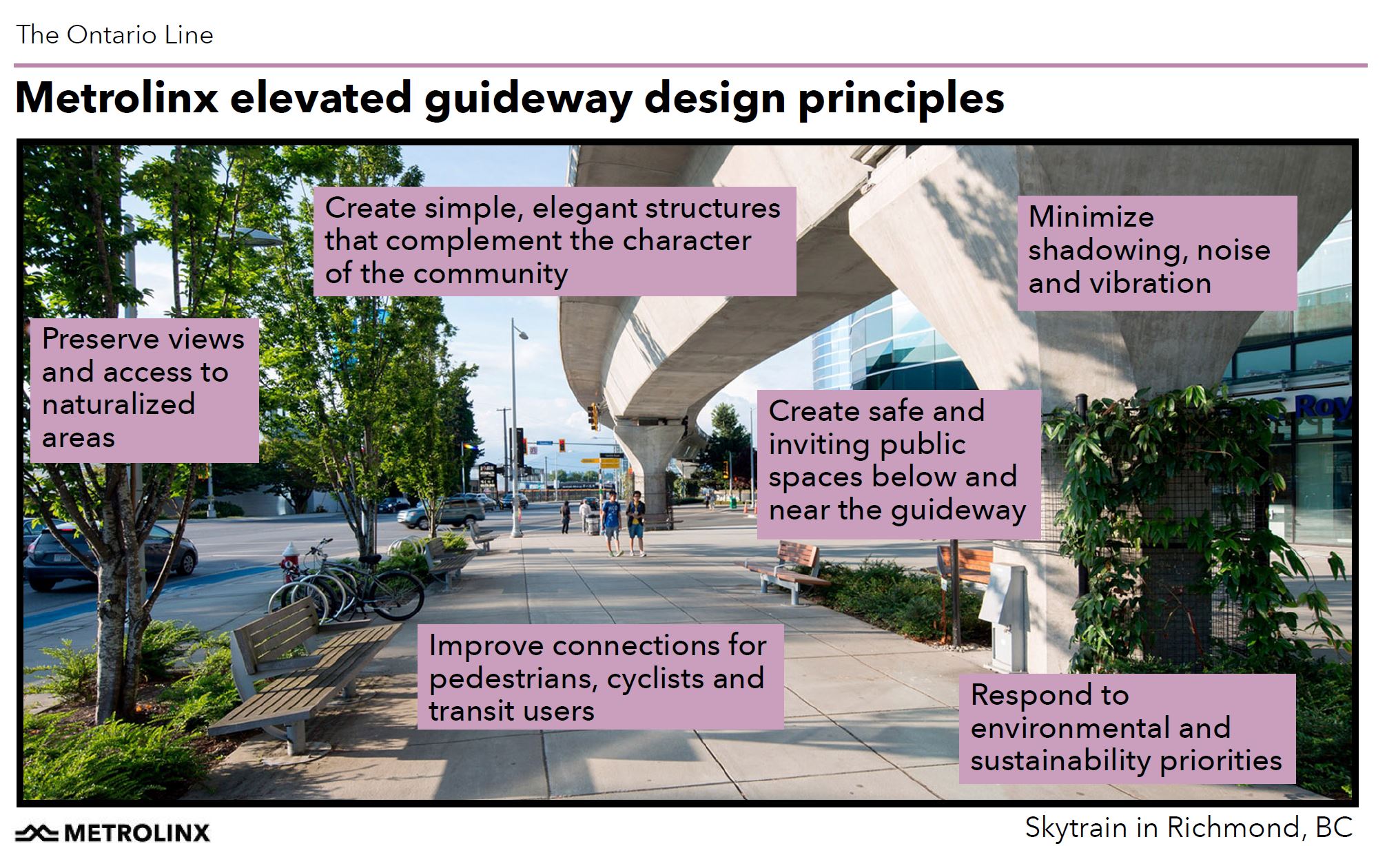
A common part of all four sessions is a short presentation on the Station Design Principles for the Ontario Line. Although interesting in its own right, this diverts attention from some of the burning issues in specific neighbourhoods. Indeed, it is clear that Metrolinx treats some neighbourhood concerns as settled issues that will not be debated further.
For example, discussion of the Maintenance Facility in Thorncliffe Park now looks at superficial topics such as how it will be designed to fit into the community, but completely avoids the issue of site selection. Based on Metrolinx replies to queries from the City of Toronto, it is likely that the same tactic will be taken with the over/under alignment question in Riverside.
To a casual observer, this can give the impression that any residual grumbling is just sour grapes from those who are not willing to give up their fight.
In this article, I will deal with the two past sessions and issues of interest raised in them. Yes, gentle reader, I have watched over three hours of video to spare you the experience.
The Q&A information below has been reordered from the sequence in the online session to group related items together. In some cases, I have my own comments on the issues and these are flagged as such separate from the voices of participants in the meetings.
Questions about station design are included in that section of the article unless they are specific to an individual station.
Western Segment: Exhibition to Queen/Spadina
The general layout of the Western segment is shown on the map below. The line begins with the station at Exhibition including western tail tracks that could be the jumping off point for future extension. The line dives underground in a portal (green) and proceeds east and north to Queen Street with stations at King/Bathurst and Queen/Spadina.
(In the map below, the 511 Bathurst streetcar line is missing, but this is corrected on the detailed King/Bathurst station map. Other transit services that are not shown include the Dufferin and Ossington bus routes.)

General Questions
Q: Will the transfer connections between the Ontario Line and streetcar/GO services be short and easy to use compared to the long walks at some stations?
A: At Exhibition there will be a New Liberty Street with bus service, and a streetcar connection including the planned western extension. At King/Bathurst and Queen/Spadina station entrances are close to streetcar stops.
Q: The Ministry of Transportation has proposed an Ontario Line Loop. It is hard to give feedback on the OL when there is a second phase with no info available. When can we see what it is?
A: The OL has built-in provision for extension north from Science Centre to maybe Sheppard. From the Ex, the line could to go west to Roncesvalles and north to Bloor.
Q: Has Metrolinx made any statement about when these might be triggered?
A: We don’t have plans today, just provision for future.
From a reply on the engagement page: Sep 9, 2021 – 09:26
“Thanks for following up and sorry for any confusion. Please note that general route as it’s been mapped from Exhibition Place through to the Ontario Science Centre is finalized. As mentioned, while we do not plan to build the line west of Exhibition Station under the current project’s scope, we are protecting for the possibility of future extensions by constructing tail tracks at both ends of the line.”
Comment: The Ontario Line Loop proposed as part of an MTO plan is considerably larger than the extensions mentioned here, and I have my doubts about its viability because it is too long and trying to achieve too many things. It is odd that Metrolinx does not have a “canned” comment that addresses this proposal as opposed to the simpler and self-evident OL extensions to Sheppard/Don Mills and to Dundas West.
Of course there already is a frequent service at Dundas West planned for the GO corridor if only there were not a transfer penalty for using it. Also, construction of the link between Bloor GO station and Dundas West subway station is supposed to begin soon. It is not clear that a “Roncesvalles Subway” is needed.
Q: The OL is projected to have 388k daily riders with light metro technology. The Expo line in Vancouver overcrowded with 98k fewer riders operating on a 108 second headway? Is there a potential capacity problem for the OL?
A: The planned 90 second headway on the OL is key, and it is built into the RSSOM contract. Trains will be 100m long, and there will be an opportunity to reconfigure car interiors if necessary to provide more capacity. Stations will have platform doors to maximize train throughput.
Comment: It is difficult to make direct comparisons of all day demand as a surrogate for peak demand and capacity limits. The OL will have strong bidirectional and off-peak demand, and this makes greater use of the capacity of the equipment. By comparison, the Sheppard subway has lots of capacity but many fewer riders compared to the Yonge line.
That Metrolinx is contemplating interior reconfiguration of vehicles (i.e. converting seating to standee space) suggests that they are aware that their design might be capacity constrained in the future. This is a direct result of repurposing the OL to act as a Union Station “relief line” for GO Transit rather than simply for subway relief.
Q: Why can’t the construction of the Ontario line start earlier than 2025? I bet the people of Markham and Richmond Hill on Yonge St. are probably losing their patience.
A: From a reply on the engagement page: Sep 9, 2021 – 09:35
“Thanks for your question and feedback. We are approaching the construction of the Ontario Line through various procurement packages, meaning that construction on different parts of the line will begin at different times. This allows us to ensure that the market has the capacity to deliver the project. Major construction under the Southern Civil, Stations and Tunnel procurement package, which includes the line from Exhibition Station to the Don River, is anticipated to begin in 2023. Under the Northern Civil, Stations and Tunnel package, which covers the rest of the line, construction is anticipated to begin in 2024.
“We are also undertaking early works activities in certain areas where construction can proceed sooner. For example, early works construction at Exhibition Station will begin this fall in 2021. You can learn more about the different early works packages under the environment section on our website.You can also find the project timeline on our website. Please note that timelines are subject to change.”
Comment: If Metrolinx were really concerned about the good folks north of Steeles Avenue, they would take the issue of upgrading the GO service, including making its fares competitive with TTC, more seriously. This would not serve all demand from Richmond Hill as many people are headed for areas well north of Union Station, but it would help.
Exhibition Station
The map below shows the Exhibition Station layout in more detail
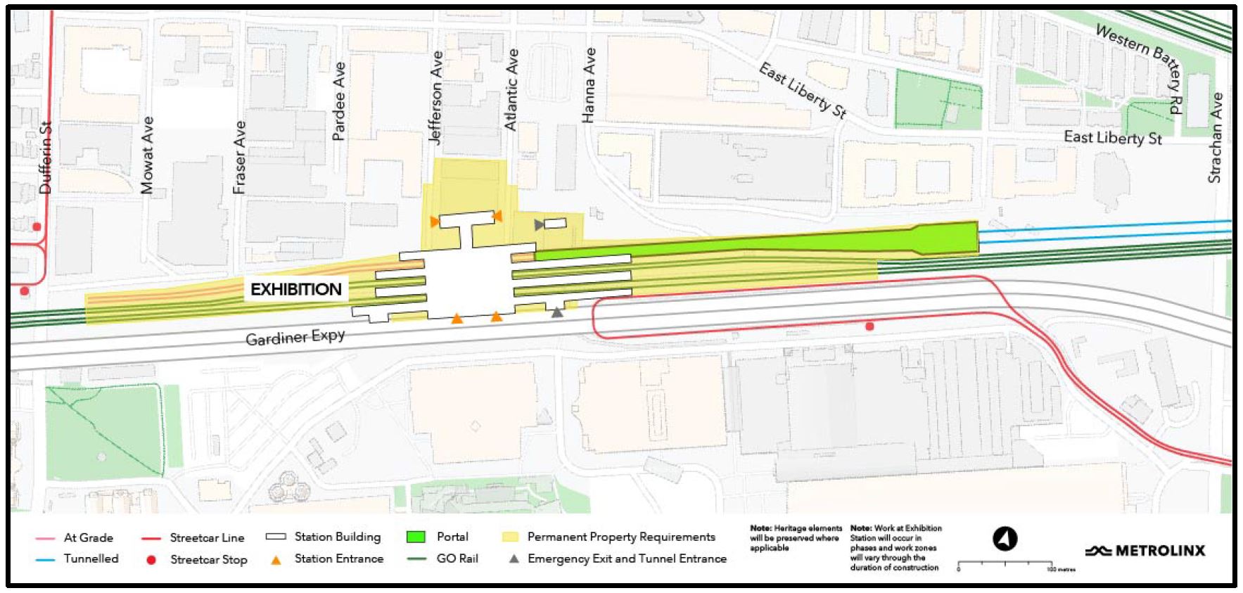
Q: The area around Exhibition station is an asphalt desert. Is anything being done about the are between the station and Ontario Place?
A: This is part of a last mile issue/study where we are working closely with the Exhibition Place Board and the City to transform the area for walking or provide “alternate means”. It is important to support development plans for Ontario Place. “Alternate Means” could be autonomous vehicles, greenscapes, some for of higher order transit with a guideway or a gondola. We are doing business case for 5-6 different proposals, and that work is drawing to a close. We will come back in a few months with a preferred design.
Q: Where is the portal, how deep is it, and will it impinge on Garrison Creek?
A: The portal is just west of Strachan on the north side of corridor. By Strachan Avenue, the line will be underground and will descend further into bedrock 30m down when it goes under the creek.
Q: Exhibition Station is too far south to serve Liberty Village well. Is there any alternative location to make it closer?
A: We consider the “walk-shed” for the station plus anticipated large transfer volumes from GO to relieve Union Station. Exhibition Place and Ontario Place are important destinations in their own right. The location is ideal for future extension.
Comment: Metrolinx commonly uses a 10-minute walk-shed to estimate station demand, but this runs into problems for urban locations where stations are close together and/or other transit services in the area might present a shorter walk. The development in what might broadly be called Liberty Village will extend north to Queen Street, and will be served by two streetcar lines plus the proposed Liberty Village GO station. These services are not shown on the Exhibition Station map.
Q: How will Exhibition station work with Dufferin extension of the streetcar line? Nothing shown on the station plan.
A: We are working quite closely with TTC on their plans for the extension (in design now) and budgeting/building are imminent. We are working with TTC to avoid interference with their plans and to make a good connection.
Q: Can you elaborate on potential interference? The station plan implies that the south entrance interferes with end of existing streetcar loop. Can you explain how your work fits with TTC design? The current graphic makes it hard to understand.
A: The map shows current streetcar loop. We are working very actively with TTC to ensure that extension will work. The TTC stop is right in front of OL station. When TTC is ready to start sharing their design, we can incorporate this in our slides, and we will ask if we can do it now.
Q: Given the number of high attendance events, just a streetcar stop with a level crossing of streetcar tracks does not appear to consider how this would work. How will the streetcar tracks would be bridged?
A: This is the challenge we face with the TTC – maintaining pedestrian flows.
Q: Will there be a higher order of transit such as LRT for south Etobicoke?
A: Extension to the west of the OL does not have a decided route. The City has the proposed western waterfront LRT, and the OL design does not preclude this.
Comment: For those who are unfamiliar with the plans, there is a proposal dating back many years to link west parallel to the rail corridor and a realigned Lake Shore Boulevard to existing trackage on The Queensway at Colborne Lodge Road. This would allow a service such as 508 Lake Shore (currently suspended) to enter downtown bypassing the congestion at King-Queen-Roncesvalles and points further east.
King/Bathurst & Queen/Spadina Stations
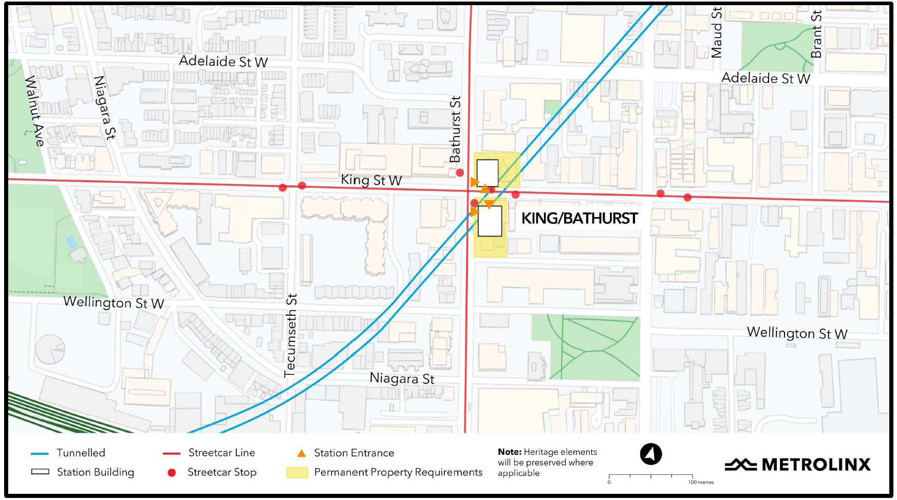
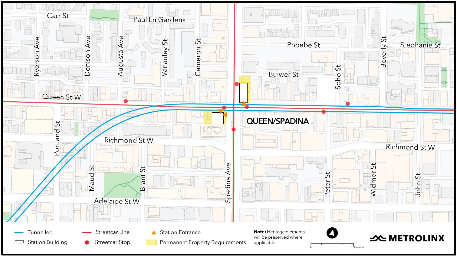
Q: How long would street closures be needed, for example at Queen/Spadina?
A: There are no planned total street closure except at Queen/Yonge. King/Bathurst and Queen/Spadina will be mined out from keyhole shafts down to bedrock on the future station entrance sites. Minor lane restrictions will be needed for deliveries and for removal of spoil.
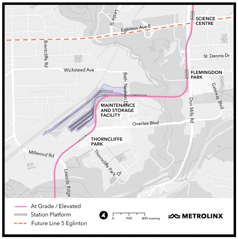
Northern Segment: Pape to Science Centre
As with the Western segment map, the area map here does not show the relationship of many transit services to the OL. Obviously these would change once the line opens, but showing existing routes would give both a sense of the existing transit granularity and potential for change oriented to new station sites.
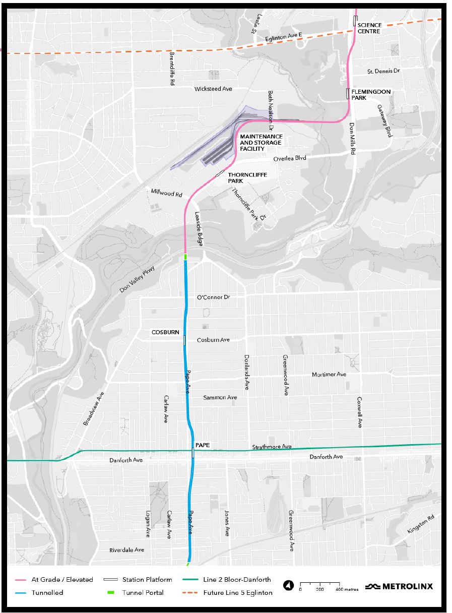
From the outset, it was clear that this session did not intend to address the issue of the location of the maintenance yard and that Metrolinx regards this as a settled question. They have moved on to the physical treatment of walls on buildings and yards, as well as to the environment under the planned guideway.
A recent bus tour of three existing sites (Greenwood Yard, Leslie Barns and the Metrolinx Eglinton Crosstown MSF at Mount Dennis) was intended to show members of the community how the design approach to this type of facility has changed over the decades. Surface treatments of walls affect the “face” that a site presents to neighbours at ground level, and green roofs provide a visual relief for those who overlook a site.
Metrolinx described the site selection as they have in the past without acknowledging the option of a “hybrid” arrangement with the MSF building south of the CPR corridor and the storage yard to the north. Any analysis of economic effects (closing businesses) assumes that the entire site north of the CPR would be used rather than only part of it.
Community working groups will be consulted on the design and physical presence of the MSF in the neighbourhood, as well as the space under the guideway, but nothing more.
The presentation deck includes several examples of under-guideway spaces such the one below in Richmond, B.C. The other examples are from Mexico City, Miami, and Jeffersonville, Indiana (a pedestrian bridge). Common to almost all photos is that the spaces are sunlit, summer views and they are unconstrained by nearby buildings. The massing of a station structure is not shown, nor are any provisions for inclement weather.
(This is very reminiscent of the illustrations fifty years ago when Ontario touted the light guideways of its maglev train system without ever showing what a station or junction would look like.)
The Environmental Assessment report will be published in January 2022 for consultation.
A major issue in Thorncliffe Park is the effect on businesses and the community they serve. Metrolinx says that this is under discussion, but will be concluded by summer 2022. Where the businesses will move to is still unknown.
General Questions:
During the “Zoom Room” section of the Q&A, two politicians joined into the session: Peter Tabuns is the NDP MPP for Toronto Danforth which includes the section of the line from the portal at Minton Place southward. Mary Fragedakis was previously the Councillor for the area, and is now the Liberal candidate who will challenge Tabuns in the 2022 provincial election. Both were concerned about public engagement and proper notice, as well as the issue of warnings on title of properties deemed to be potential transit lands.
Metrolinx stated that there will be a significant consultation on the Pape Avenue section soon with good consultation materials
Q: Can you start notifying residents of Pape Village about these meetings? Not just property owners but also renters.
Q: Why have you disengaged with community groups to provide honest and meaningful engagement?
A: Metrolinx replied “Our goal is a truthful engagement with the community” and there is “sincerity in which we deliver our projects”.
Comment: I miss the days of public meetings when laughter would have rung through the room.
Q: With work-from-home changes, do we really need to spend the money on this? What is the total cost of the OL?
A: This is a city-endorsed project that is a long time coming. The line doesn’t just take people downtown. Return to work is happening, slightly modified from pre-covid, but happening. The announced budget is $10.9 billion.
Danforth to Cosburn
Q: What will be the construction effects on Pape?
A: The OL will be in an underground tunnel in the right-of-way north of Pape Stn.
Q: What buildings will be torn down for Cosburn Station?
Q: Will the line run under Pape or under Muriel (1 east of Pape)? How many properties will be taken along Pape?
A: Property requirements are just being finalized, and Metrolinx does not want to hazard an answer. This section is in the last part of contracts and designs are less developed. Metrolinx will bring designs to community when they have something, in the not too distant future.
Comment: Metrolinx claims that the alignment is within the Pape Ave right-of-way and therefore would not affect off-street properties. This directly conflicts with the plans shown for a Cosburn Station on the west side of Pape, as well as an alignment from Danforth northward under Muriel.
The description of Cosburn Station in the Neighbourhood Update page is quite clear:
By positioning Cosburn Station west of the street, fewer of the buried utilities will need to be relocated, including the recently upgraded water main. While the property requirements for this approach are comparable to what would have been needed if the station were built directly under the street, an added benefit is that there will be fewer impacts to area traffic.
Source: Neighbourhood Update North (Cosburn)
As for the section just north of Pape Station, the map on the Neighbourhood Update page clearly shows the line running beneath houses on the east side of Pape, while the map above appears to show it further east, under Muriel Avenue.
Either Metrolinx has revised the alignment again and its maps are wrong, or they “misspoke” at the public consultation. A clarification is definitely required on this point.
Portal and Valley Crossing
Q: Why can’t you use the Millwood bridge rather than building a new one?
A: The existing bridge was built some time ago [1927] and was widened. It does not have the structural capacity for the OL. Also, the alignment does not work. The curves to turn east from Pape and then north onto the bridge would create noise and vibration. The curves at Union Station are an example of what could happen. A better design was a new modern structure.
The bridge design fits the context. Underneath, Metrolinx will be careful to minimize number of piers and effect on the valley floor.
Q: Will the DVP have to be closed?
A: No. One or two evenings will be required to install bridge girders over the DVP, but this could possibly be timed with a regular shutdown for maintenance.
Q: A drilling rig crew said that the bedrock at the portal is almost 180ft below grade. What does this mean for design, construction, and safety of the portal?
A: We will not be driving piles to bedrock, but will use secant piles for a “bathtub” structure. Piles do not need to reach bedrock to be effective. There are two types: one bears on bedrock, and the other is a friction pile.
Q: Will there be an effect on slope stability at the portal?
A: Work in the area will take some load off of the slope. The actual timing of this work will be late 2023/24.
Q: What steps will be taken to counter the effect of removal of trees on soil erosion/movement?
A: We try to limit tree cut downs, and have a replacement program. Where there is a potential for erosion, the project company will have to put together a plan to protect the slope with treatment for steep areas.
Comment: This question, I suspect, is related to the situation on Eglinton at the Brentcliffe Portal where there was a partial collapse of the north side slope at a location cleared for road widening. That was triggered by addition of the LRT right-of-way requiring a shift of the road, but not by the portal construction itself.
Q: The Minton/Hopedale neighbourhood near the portal has heard hints that the final number of properties required will be greater than four.
A: We are working our best to stay within these four properties. Community amenities for this area after the portal has been build are to be determined.
Q: There are regularly deer near the portal site. What will be the effect on the deer population?
A: The EA is in progress and is coming in January 2022. We will address the deer in the EA.
Thorncliffe Park
Q: What provision will there be for green space and public space along the line. How will space aound elevated stations at Thorncliffe Park and Flemingdon Park be used, as well as the parkette formed by the space above the tunnel portal on Minton Place?
A: We are looking all along the alignment for community needs, spaces and gathering points, and we want community and City input.
Q: Regarding the level of engagement in ThorncliffePark: most of the people here do not speak English as their first language and yet the literature distributed the day before this meeting was only in English as this town hall. The “pop-up” was a desk in front of the Thorncliffe Park library, but it was unannounced. This is a sham consultation.
Have you done independent audits re crowds, traffic, noise effects in an area with Toronto’s three largest schools? Where are you moving the businesses to? What about the mosque?
A: We do have means and methods to engage in other languages. As for design studies, we did not target any community for our facilities [e.g. the MSF]. We are getting positive feedback from the pop-ups. We are working with the businesses to see where they can go, and the Mosque is already relocating to 20 Overlea.
Q: I am disappointed with the pictures. There is no picture showing how the guideway will fit into Overlea Boulevard. What will be salt effects on structure?
A: We don’t use salt on guideways. Gardiner-style corrosion will not happen.
In the presentation materials, we just wanted to give a sense of what a guideway might look like. A community survey is yet to come.
The guideway is on north side of Overlea, not in the median.
Yes, there will be renderings of what the guideway will look like on Overlea and on Don Mills.
Q: An online petition, which has been taken down now, revealed that 11,000 people did not want to see the MSF in their community, and yet Metrolinx is determined to put it here. Could the line be run out to Millwood along the north edge of Thorncliffe Park taking it completely away from Overlea and the condos on the south side of the road?
A: The alignment shifts north from Overlea as soon as possible, and lines up with second Don Valley crossing. We miss the schools at Don Mills/Overlea.
The station is within a 10 minute walk of almost all of Thorncliffe Park, a good catchment area for transit users. We have heard is that a subway coming to community is seen as a good thing.
The MSF is in very best location, as good an outcome as possible. It straddles the hydro corridor with the maintenance and operations building beside the CPR tracks. A lot of activities will take place inside this building, and this could provide local employment opportunities.
Comment: This exchange was all over the map and missed or ignored crucial points including:
- opposition to the MSF relates not to the building, but to the yard location and its displacement of local businesses;
- community access to jobs will depend on the system’s operator, not Metrolinx, as well as the specialized skill sets that will be needed;
- relocating the line to the north edge of Thorncliffe Park would put the station far from potential riders, and could also conflict with the Hydro station at Millwood.
Q: There have been various reactions to the OL from different communities, residents and businesses. After all this disruption, what will the community get? Many people not aware of what’s going on. Many more want to see the line built. Metrolinx should get a better sense of what community wants. If a community centre, such as in the Finch LRT project, were included, would this improve acceptability?
The Mosque was originally going just across the street and would include community centre. Thorncliffe Park is losing a community centre they were expecting to get.
Q: Why isn’t more being invested in transit both for climate change and for those who must travel to work, especially in outer parts of the city.
Flemingdon Park and Science Centre
Q: Can Science Centre station be underground like Yonge/Bloor?
A: The wide roadway was one reason we went above grade. With the ambition for future extension to the north, an above grade line is easier to extend. A large amount of transfer traffic to/from the OL will be from buses, and we are directly above the bus loop. If we were underground, it would be like going under Queen or Pape Station and we would be very very deep. This would also make an extension much more challenging.
Q: 2,000 units of housing including 700 affordable plus a TDSB school will be built at Don Mills & Eglinton. On other projects (Crosstown and Finch), stations were not designed to be built over. What plans are there for Pape and Cosburn stations?
A: Where we have a station and community support we are including reinforcing for overbuilding.
Maintenance & Storage Facility
Q: Why not locate part of yard north of the CP and connect via an elevated overpass?
A: Metrolinx recited their previous work looking at 9 sites and their criteria including that the choice should minimize effects on businesses and jobs. If the MSF were north of the corridor this would be a difficult configuration and many jobs would be lost in the “Wicksteed” site. The “hybrid” option chosen avoids this. This was a tough decision, and they are proud of it as the right one for transit.
Comment: A hybrid design such as advocated by some in the community was not evaluated, or if it was, the results were never published.
Station Design
Several questions in the two sessions touched on issues related to stations in general, and I have included them here.
Q: Will there be an opportunity for the public to have a say in station names?
A: The current names are only working names. Full consultation on naming stations, as well as the Tunnel Boring Machines, will follow.
Q: What provision is there for DWAs (Designated Waiting Areas), phones, and on-platform assistance?
A: Stations will have seating, higher light level, passenger intercoms, other amenities like charging stations, but no phones. The DWAs will be located near elevators.
Q: Will there be indoor or outdoor retail outdoor retail and food outlets?
A: Exhibition station has a large concourse planned as an amenity for both the general public and transit users. Other stations have minimal provision for retail, although this could be included in future development. More details are to come including reference concepts. This ties into civil work contracts.
Q: Will there be provision for bike-and-ride with indoor or outdoor storage?
A: We are very actively pursuing opportunities for bike storage at some locations (but not at interchange stations like Osgoode). We are treating this as an intermodal connection. At King/Bathurst, Queen/Spadina and especially at Exhibition there will be secure long term bike parking, and extensive sheltered exterior parking. This is a priority in planning stations.
Q: Elevators: How many elevators will there be at stations?
A: There will be a minimum of two street to platform elevator paths. Exhibition station has about 14 elevators, and there will always be a redundant route. Twin elevators will be installed wherever possible (heritage buildings constrain some locations). Elevators will be larger than those that are already in the system, and they will be “flow through” with entrances on one side and exits on the other.
Stairs will be sloped at 30 degrees, slightly shallower than we see elsewhere, but the same as escalators. If possible, escalators will be arranged in a “cascade” or “waterfall” design so that there is a clear, continuous path between levels.
Q: What font will be used for wayfinding signage?
A: We are using the Metrolinx standard including mixed case text. It will be similar to GO, but standards evolve/improve with time and so some existing signs may be based older standard. Also, Metrolinx will co-ordinate with TTC for consistency in signage at shared stations.
Development Near Stations
Q: What construction impacts would there be at Queen/Spadina, and potential condos on top of entrance sites? How is Queen preserved as a lower scale area? What would condos such as shown in one rendering do as a precedent in the area?
A: We have entrances that can be incorporated into a Transit Oriented Community. Infrastructure Ontario is managing that in collaboration with the City, and IO will make announcements about the lands. For further information, go to Infrastructure Ontario’s engagement site.
Comment: Note that the IO site linked here includes descriptions for Corktown, Exhibition and King/Bathurst, but not for Queen/Spadina, nor for any stations east of the Don River. (Updated September 22 at 5:00 pm: Queen/Spadina is now included on the IO site.)
Notices on Property Titles
Q: How will the transit corridor lands provision affect areas around the OL?
A: Metrolinx replied (at the West segment meeting) with their usual claim that they want the ability to do things along the route when needed. In the North segment session, Metrolinx appeared to be open to a staged release of their Notices on Title as portions of the OL are completed. With respect to intensification at lands Metrolinx procures, this is managed by Infrastructure Ontario.
Arising from questions and discussions with MPP Tabuns and former Councillor Fragedakis, Metrolinx revealed that they are now considering changes to the transit lands designation:
- Whether some properties could be released prior to work completion once it is known that they will not be required.
- Whether there could be a staged release of the transit lands designation rather than having to finish the OL end-to-end before removing the notices on title for completed sections.
Although they were asked, Metrolinx gave no commitment on a policy for release of property interests.
It would appears that Metrolinx has washed its hands of property development questions and has left this for Infrastructure Ontario (who were not present at the meeting) to handle.
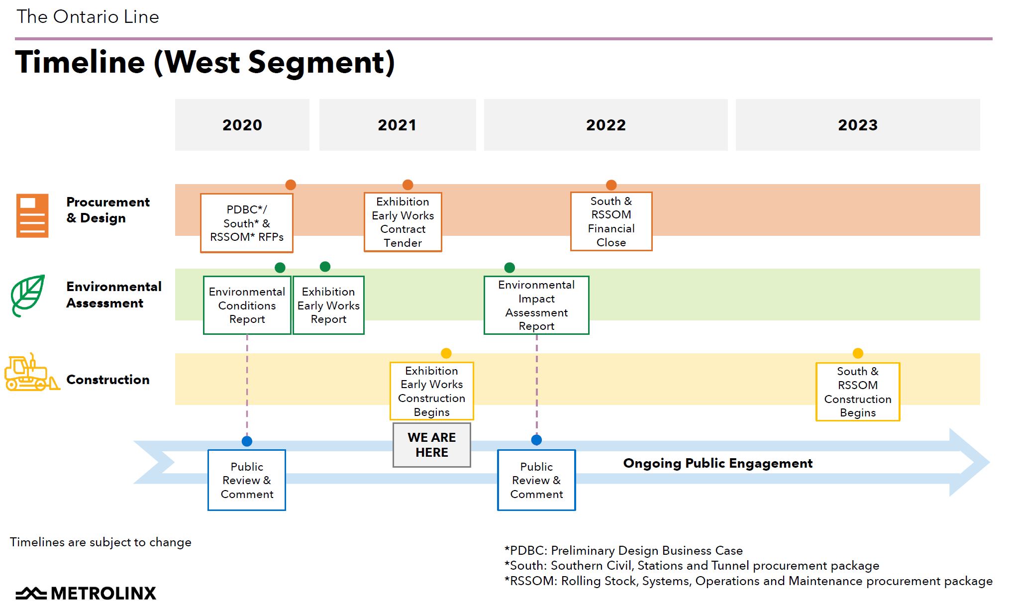
Construction Timelines
Western segment:
This chart does not include the South Civil, Stations and Tunnel contract for which the most recent Infrastructure Ontario report shows an execution date of Fall 2022. This and other planned dates put the launch of the significant phases of construction just beyond the 2022 provincial election.
Whether a new government will elect to “pause” the schedule and make changes remains to be seen. Given the many other pressures the government will face, and the long-standing demand for some sort of “relief line”, I would be very surprised to see any significant change in what Metrolinx has proposed. There could be much hand-wringing, but for a project too far advanced to be substantially modified.
A more significant change could be to the structure of the proposal moving away from a P3 configuration, depending on which party is in power at the time.
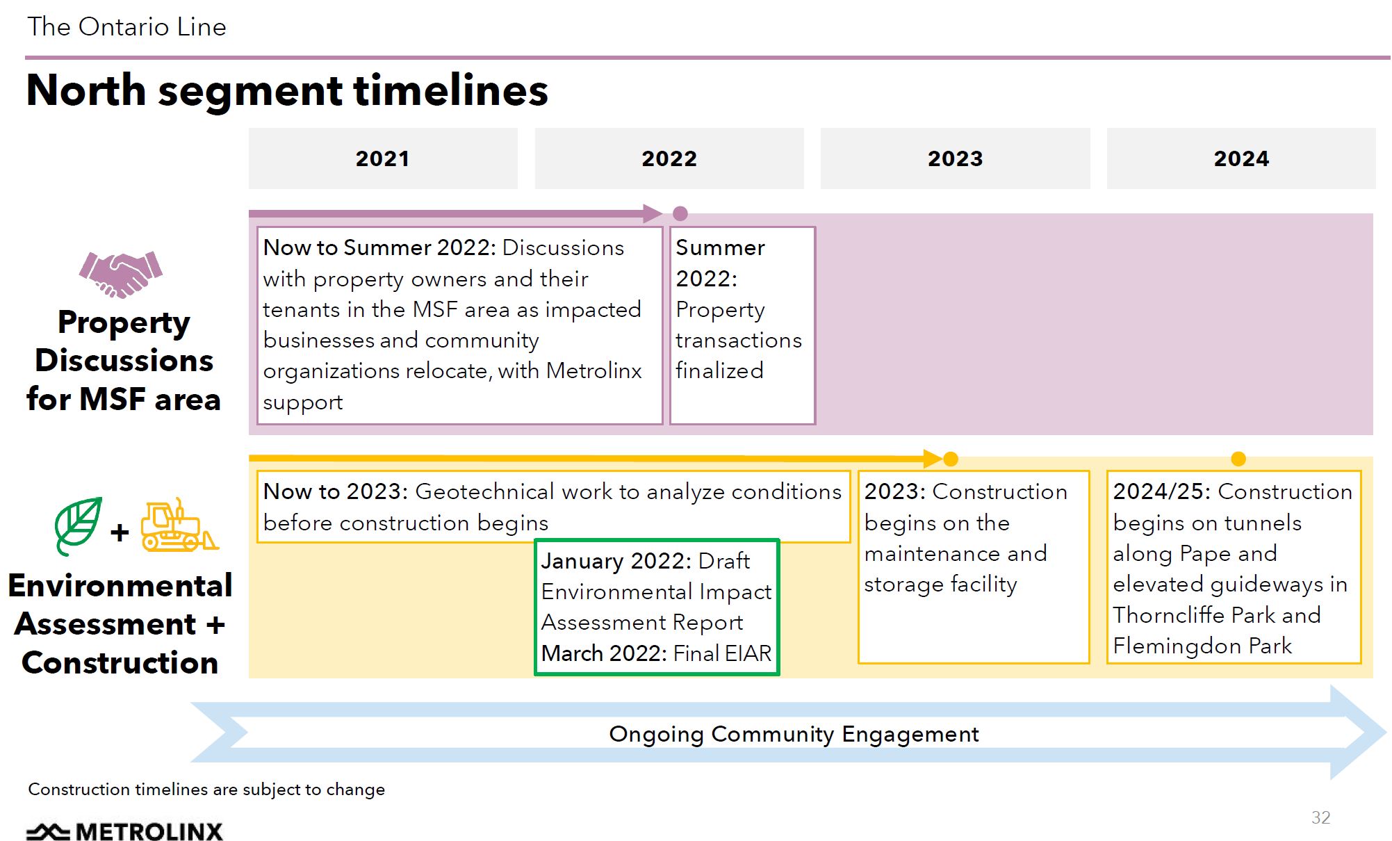
Northern segment:

It’s absolutely insulting they are ignoring legitimate comments and making it seem like there is no opposition or even decent questions being asked.
LikeLike
Thanks Steve. More later, ie. where are the options??? But I really liked your comment of:
Steve: A huge disadvantage of this format of public “participation” is that Metrolinx gets to make their pitch on their own terms, rather like an unchallenged sermon.
LikeLike
Though Metrolinx may have changed their consultation date for the Downtown segment, Infrastructure Ontario still seems to have four dates for THEIR consultation on downtown stations. Corktown (or, as I prefer, First Parliament) on 27 September; King Bathurst on 29 September, Exhibition on 4 October and Queen/Spadina on 6 October. See:
Steve: Thanks for this update. Queen/Spadina is a recent addition. I have updated the article.
LikeLike
The western segment route cuts diagonally as it swings from Queen to the LSW rail corridor, and passes under several building. Let’s hope they got it right, and there will be no conflicts with the foundations.
Regarding the total capacity, it is a common knowledge that OL is expected to serve dual duty, the subway system relief and the Union hub relief, while utilizing smaller trains than the TTC’s existing subway lines. No way that will work perfectly; let’s hope it will provide some relief and won’t choke in the process.
Steve: The tunnel will be in bedrock below the building foundations, according to Metrolinx. As for the dual role, this could be a problem for Metrolinx on two counts. If they are successful, especially from the east where anticipated demand is higher, with diverting Union-bound traffic off of GO, they will constrain the OL’s capacity for longer term subway relief including the benefits of an extension north to Sheppard. Conversely, if their projections for Union are correct, but they are not able to divert traffic away from it, then that hub faces a major capacity crunch by the 2040s. What is quite frustrating in all of this is that Metrolinx has not published the modelling on which they base their projections.
LikeLike
The pandemic was the best thing to ever happen to Metrolinx. It allowed them to move forward with their suspect plans without having to face any of the riff-raff.
LikeLike
While certainly rather convenient for “consultations”, they might disagree given the loss of their captive customer base/cash cow and political base, the commuters from 905 to offices around Union.
LikeLike
I’ve been getting in to Ed Levy’s book again, sigh. What’s proposed is only half the length of the 1957 plan as one eg., and a list of vexes could begin with why are we detouring to give heavy costly transit to the Portlands area when Liberty Village is remaining relatively bereft? (Though it is biking distance to the core, for sure, and the King RoW is/was a Big Help, and maybe an example of how political will can save billions, maybe? ie. lessens for the DVP car traffic and boosts to transit usages;).
And up in Thorncliffe, there’s a very large and lightly used parking lot of a mall on ‘south’ side of Overlea vs. taking over and destroying a vibrant mall of good use to the community, and why not put the trainyard in the parking lot, or throw provincial weight around to strip off the corner site and rebuild the mall, with non-profit housing atop? Oh, we can’t afford to since we’re squandering billions in Scarborough for a Stupid Subway Expension (SSE), right, and the NDP are FINE with that.
There’s also a frustrating bad pollution of the now-schemings where the shitizens get to try to deal with a limited set of options, and with scant resources compared to the behemoths of governments, some far worse than others, ie. CON-tario, and the federal Liberals are also keen on buying suburban votes, and I guess it worked. The transit seems really complex and costly, but we aren’t seeing options and clarity of info sometimes/often, so we’re poised to blow billions because of politcal reasons, vs. some mere tens of millions for better sets of plans and options, like doing a straight line for east-west and maybe we need two, or even three, or four projects, like the silver buckshot, not silver bullet.
Returning to Mr. Levy’s book, he was opining that the way we do/have done transit is about opposite of what other places do with most costly/resource intensive subways in lower density suburbs, with no upgrade in land use/abuse, and let the core choke, and so it’s really too bad that the drastic decline in transit riderships through the pandemic isn’t at all reflected in the plannings, though with the climate emergency, we need transit, but it should be done on the emergency basis, not the eventual megaproject (which has an air of so heavy it’s meant to drag transit down) in favour of carservative wins and ongoing free rides.
Hopefully not too many more contracts will get signed; any political will to do as Davis did and stop some exce$$ with the Spadina highway, though yup, we goofed on the transit just a short time later ie. should have been Bathurst, which would have cost more, yes.
And does all of this deflect from getting far more user pay for the mobile furnaces’ costs?
Steve: To be fair to the Port Lands, there is almost no transit there at all, certainly not two streetcar lines (King and Queen), two buses (Ossington and Dufferin), and (eventually) two GO stations (Exhibition and Liberty Village) that Liberty Village has. The cost of serving the Port Lands with the Waterfront East line is small change compared to other projects, and the biggest part of it is the reconstruction of the Bay Street tunnel which was undersized to begin with and strains under the current demand for Waterfront West.
LikeLike
Thanks Steve, (and commenters). There’s a HUGE amount to try to be atop of, and many many thanks to you, but with the undersized Union/Harbourfront loop (like all of Eglinton LRT tunnel), maybe there could well be a surface solution, with some digging maybe, or if we’d been smarter – like when all of Front St. was dug up to somehow clear out all the maze of utilities to create even a single RoW option – maybe we could also have some multi-millions to spare, as this project won’t be so cheap either, and who would have thought that doing heavier transit so near a lake through lakefill would be extra-costly, and funny how the public gets to pick up the tab, though tax dollars from all of this lakefill are likely astronomical, and used to support suburbs, and freer rides for cars, right?
I recently saw a Dilbert cartoon in the Globe that made me laugh where one participant says “I compared the R.O.I. for lying versus telling the truth. I regret to inform you that lying has a five-to-one advantage.’ A questioner- ‘Is that true?’ “I won’t be taking any questions’.
LikeLike
I see 90 seconds headway on the trains. New York gets that on one of their lines, but they do it with 4 tail tracks on 2 levels. How do they expect to get it with the planned configuration, particularly since they are expecting heavy loads at both terminal stops.
LikeLike
If you believe the urban legends, I wonder if they can re-use the mythical tunnel from Fort York to the Wheat Sheaf.
LikeLiked by 1 person
No questions about the location of “Science Centre Station”, in relation to the Eglinton Line? It looks like a very poor connection.
Steve: This session was about the section from the Don River east. Science Centre Station was covered in a previous session. Metrolinx claimed that the majority of transfer traffic to the OL will be from the buses, not the Eglinton Crosstown, and so an OL station underneath the Crosstown would be a longer transfer for a majority of riders. Of course the fact that they didn’t built provision for such a station into Science Centre Station shows what constitutes “planning” at Metrolinx. At the point the station was designed, it would have been the RL North and underground, not the OL on an elevated. This is another of the breadcrumbs showing how Metrolinx did not take planning for the RL North seriously when it was supposedly their responsibility.
LikeLike