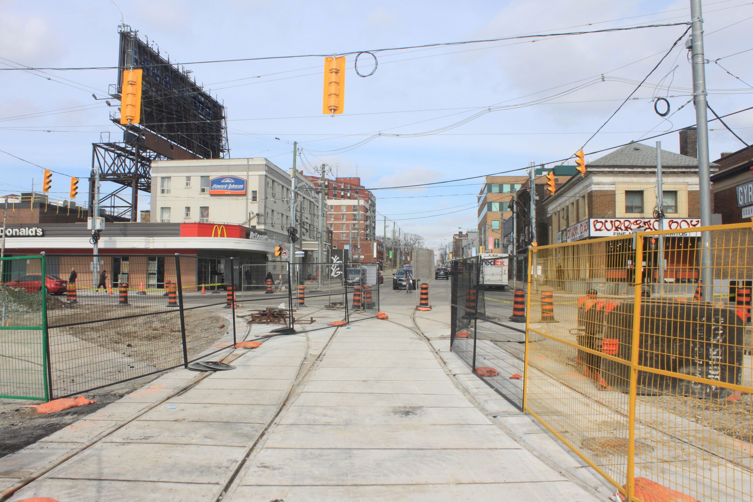
Construction has resumed, although not exactly at a “breakneck” pace, at the complex junction of King, Queen, The Queensway and Roncesvalles. Here are photos showing the current state of things.
Slip Lane Removal
On the southwest corner of the intersection, there used to be a “slip lane” that allowed eastbound traffic veering from The Queensway to King Street to bypass the signalled intersection. This was fine for motorists, but a danger to pedestrians. In the new intersection layout, this lane has been removed and the sidewalk will be expanded to make this a conventional 90-degree junction.
Looking NELooking NWLooking SE
King Street Realignment
King Street formerly met Queen at an angle, but this has now been straightened out. With the new intersection geometry, the two streetcar lanes split apart east of the intersection. This will align the future tracks on the north side with sidewalk “bumpouts” for the northbound and southbound carstops.
Looking N from KingLooking E along King
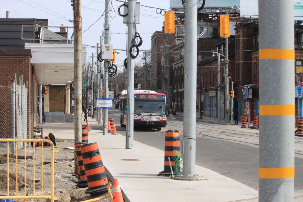
Track and Overhead Construction
Many new overhead support poles have been installed around the intersection, and they are festooned with coils of future span wires. West of Sunnyside Loop, excavation of the trackbed has started together with construction of foundations for centre support poles.
Looking W across RoncesvallesLooking E across RoncesvallesLooking W on The QueenswayLooking W at SunnysideLooking E at GlendaleLooking W at Glendale
Planned Restoration of Streetcar Service
In the announcement of February 2022 service changes, the TTC anticipated that 501 streetcar service would be restored to Sunnyside Loop in the May 2022 changes.
In May, the 501 bus shuttle will be shortened from Broadview to University, but streetcars will continue to operate only to Bathurst Street (Wolseley Loop). I have asked the TTC for an update on streetcar service restoration and await a reply.
After the publication of the monumental draft Ontario Line Environmental Impact Assessment Report (EIAR), Metrolinx organized four online “open houses” to present an overview of the report and to address questions. These took place in late February and early March during a 30-day period for public comment that ends on March 9. Those of you with a desire to spend many unproductive hours hours waiting for occasional pearls of wisdom to emerge can do so through the Metrolinx Engage website:
In two separate articles, I will summarize the major questions from each pair of sessions. However, there are general issues raised by the draft EIAR and the process for public input that deserve their own debate.
Politicians and managers who never read beyond the glossy brochures, or, maybe, the Executive Summary, might mistake sheer volume as a measure of transparency, an heroic effort to inform and involve affected communities.
Back in the days of real telephone directories, the size of the phone book was, among other things, a measure of how grand a community might be. Big thick book equals lots of phones and lots of people, a matter of pride even if the type got smaller and smaller as years wore on. But for all its heft, the directory had a basic organizing principle: if you knew how to spell someone’s name, or even made a reasonable guess, you could find their address and phone number.
The many thousands of pages in the EIAR and its sundry appendices, not to mention equally large reports that preceded it, are bricks in a wall of obfuscation, not revealing windows into our future. Nobody (no, not even I) has read every page if only because there is only so much time to devote to the subject, and there is a lot of badly organized, repetitive information. Key topics one might expect based on past projects (including the Relief Line South study) are missing because these details will not be worked out until after the design/construction contracts are awarded, and the opportunity for public comment only a distant memory.
If the desire were to construct a project that would frustrate public participation, it is hard to imagine how Metrolinx could have “improved” on what they achieved. An exercise in going through the motions. A triumph of superficiality disguised by the sheer volume of reports.
Metrolinx will hold two online open houses covering the draft Environmental Assessment Impact Report as it relates to the southern portion of the line from Gerrard to Exhibition.
Last June, I posted a long article about plans for the Waterfront East LRT and the designs as they were then proposed. See Waterfront East LRT: June 2021 Update.
Although the next full project update will not come to Toronto’s Executive Committee until the end of March 2022, a revised proposal for the treatment of Cherry Street was presented to Waterfront Toronto’s Design Review Panel on February 23. I have only included a selection of illustrations from the presentation deck in this article, and I recommend that interested readers browse the full set.
As described in the June 2021 update, the link from the existing Cherry Street trackage under the rail corridor to New Cherry Street will be made through a new tunnel through the rail berm east of the existing Cherry Street underpass. However, the original plans for the area involved a small forest of, yes, cherry trees and this has proved impractical. The water table is very high and the underpass is a low point in the surrounding terrain. Any high water event would flood the area.
The new design starts from the premise that the water should be controlled and included as part of the landscape with a marsh around the new transit corridor as the proposed solution.
The illustration above shows the area where Distillery Loop is today. The Cherry Street signal tower is a landmark that, in the proposed alignment, would be shifted east. An alternative scheme leaves the tower where it is and the streetcar tracks swing east around it.
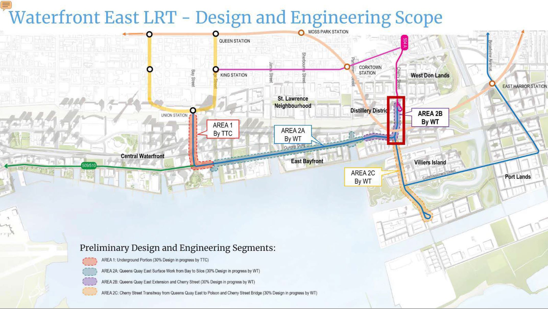
To put this in a wider context, here is a map of the overall waterfront area showing various projects. Only the area outlined in red is the subject of the current report.
Please see that article for general comments about route behaviour.
The short version:
Like 64 Main, 92 Woodbine South is one of the shortest routes in the system, and it serves a nearby neighbourhood.
Unlike 64 Main, there does not appear to be any problem with the adequacy of scheduled travel times, and buses routinely have time for terminal layovers. These occur frequently because a one-way trip is 12 minutes or less during most periods including scheduled recovery time.
The schedule was unchanged during the entire three month period.
During some periods, notably the am peak and late mornings, service is well-behaved almost all of the time.
There is a peculiar behaviour at about 1:30pm on most weekdays, more prevalent later in the year, when both buses take extended layovers at each terminal causing a gap in service.
Traffic congestion is rare on this route, and occurs most commonly northbound toward Kingston Road in the mid-afternoon possibly due to traffic backed up on Kingston Road itself where parking restrictions do not take effect until 4pm.
Some bunching occurs primarily in the pm peak, but not to the degree seen on other routes. There were cases when all three buses travelled in a pack over a round trip.
Missing buses contribute to irregular headways especially after mid-November when the TTC began routinely cancelling crews. This does not happen every day.
Where one or two buses are missing, those remaining in service might, or might not, adjust their schedules to even out headways. In some cases, notably when only one bus is in service, longer-than-normal terminal layovers contribute to the already widened headways. Half-hour gaps occurred where scheduled service was every 12 minutes on several early evenings.
Service on weekends is generally more reliable than on weekdays.
Service on some holidays operates much more frequently than at any other time, probably a leftover from summer schedules.
In a previous article, I gave a grand tour of the Ontario line showing the general layout of stations and the alignment of the route. However, Metrolinx has yet to publish anything beyond station footprints – the areas stations will occupy, and by extension the buildings that will be removed or altered to accommodate them.
Infrastructure Ontario (IO) has a parallel process for the design of Transit Oriented Communities (TOCs) which are intended to focus development at stations and, in part, to recoup the cost of construction. To date they have conducted public consultations for four locations: Corktown, Exhibition, King-Bathurst, and Queen-Spadina.
Within each site’s page there are links to the videos, presentation decks and to the detailed building plans as submitted to the City of Toronto.
The illustrations in this article are taken from these presentation decks:
The online sessions have a format familiar to those who have watched or participated in Ontario Line sessions: a lengthy presentation followed by a short, moderated Q&A. For those interested in details of specific sites, to the extent that IO revealed them, I recommend watching the videos of the consultation sessions.
The proposals shown are conceptual, and there is no guarantee that what is eventually built will include key details worked out with communities and city planners. The provincial record on transit projects and consultation is far from trustworthy.
These developments are quite large compared to what is there today. Affected communities have pushed back about the scale and density. IO has made some changes, but mainly by rearranging the physical volume of buildings while leaving their overall size intact.
A common point IO makes, just as any other developer would do, is that the neighbourhoods around stations should be judged not on their current form, but on what they will become with developments already in the pipeline. This sort of catch-22 plays out all over the city. Once a very tall building is approved, often by force of provincial decisions, not by local planning, this sets a precedent for everything that will follow.
Land nearby a transit station (defined as within 800m or a 10 minute walk) puts a great deal of the city under its umbrella. Provincially-mandated growth is a blanket excuse for larger buildings even if the resulting density greatly exceeds provincial targets.
There is a more general issue about TOCs in that they are primary residential. Transit demand is easier to concentrate with commercial buildings such as in the core because of the many-to-one commuting pattern. Residential buildings tend to generate trips outward in whatever direction there is a convenient path such as a nearby highway or transit line provided to a destination. A related issue with new residential development is the amount of parking included and, therefore, the relative attractiveness of longer road trips vs transit trips.
If a so-called transit community features parking for all of its residents, this does not give transit a “leg up”. These sites, as planned, do have a preponderance of bicycle parking over auto spaces, and many buildings have no auto parking at all. Whether this ratio survives to actual construction remains to be seen.
Another key point is timing. Occupancy of the proposed buildings is aimed at the early 2030s because they will sit on top of future stations. Even at Exhibition where the TOC development is north of the joint GO/OL corridor, construction is not slated to start until 2029.
The upside is that transit will already be there when residents move in. This is totally unlike what happened on Queens Quay where development has preceded good transit service.
To jump to a specific station, click the links below:
This article continues the series on service reliability on short routes. The common theme is that the routes in question have short trips, and recovery to scheduled times should be simply achieved. Most of them also have little traffic congestion, and that cannot be cited as the root of all problems.
On some occasions, particularly later in the year when staffing shortages hit the TTC, some buses might be missing. However, this does not explain irregular headways when all of the scheduled vehicles are in service.
When one bus is missing on a short route, this can have a big effect on the service level especially when there were only two or three to begin with.
The TTC claims that some of the gaps are actually filled by “Run as Directed” (RAD) buses, but there are problems with that explanation:
There are far too few RADs in service at any time to fill the missing service seen on many routes across the system.
If a RAD operator takes over an open, scheduled crew, then the bus should run with the proper route identification and show up in the tracking logs. “Route 600” RAD buses only make selected trips on routes and do not appear in route-specific tracking logs.
If all of the scheduled buses are in service, but they are running erratically, notably with two or more buses running together, this is an issue line management and service spacing.
In this mini-series, I will review the following routes:
64 Main
92 Woodbine South
121 Esplanade-River (formerly Front-Esplanade)
124 Sunnybrook
(For those who are wondering, the next group on my radar will be many of the major routes in Scarborough.)
Note that due to the cyber-attack on the TTC and the recover efforts that followed, there are no data for the following periods:
Friday, October 29 to Saturday, November 6
Sunday, November 7 data begin after 10am
Friday, November 12 through Monday, November 15
Saturday-Sunday, November 20-21.
There are also no data for:
Friday, October 15 to Sunday, October 17 at about 2pm.
Saturday, October 23 from about 10pm to 11pm.
Despite these gaps, plenty of data remains to show how the route behaves.
The short version:
Scheduled running times were too tight on 64 Main until mid-November. This was “fixed” by buses dropping trips to get back on time, and less service was provided than advertised.
Ongoing problems with missing buses and bunching compounded the schedule issue, and persisted into December.
Weekend service was particularly bad when only one bus was operating.
With very rare exceptions, there are no problems with traffic congestion as a stock excuse for irregularity in service.
The TTC Board met on February 8, 2022. Several hours were spent in private session on items that reported only by name in the agenda. They primarily relate to litigation (one item involves an as-yet unsettled claim regarding a contract for the Spadina Subway extension to Vaughan) and Labour Relations.
Updated April 7, 2022 at 9:45 am: Metrolinx has responded to a query about possible errors and inconsistencies in the EA. See the Errata section at the end of this article.
In this article, I will primarily review the alignment drawings provided in the EA and some of the information about station form and construction, to the extent that Metrolinx has provided this.
Notable by their absence from these documents are drawings of the actual structures above or below ground. This makes it almost impossible to assess, for example, the on street presence of the elevated structure between the north end of the Leaside Bridge and Science Centre Station, nor of new station buildings wherever the line is above ground. Underground structures, essential to an understanding of how the stations will connect to neighbouring buildings and to other transit lines, are also not shown.
I wrote to Metrolinx asking about this, and they initially referred me to the Neighbourhood Updates segment of their engagement website. There is less information there, in most cases, than in the EA or other already-public presentations (which could be out of date). I wrote again, and they replied:
Hi Steve – those additional images will be posted as soon as they are available.
We know folks are anxious to see those images and we are working to get that information available.
It is baffling how people are supposed to assess information in the EA if they cannot see what Metrolinx proposes to build.
On a similar note, there is a general problem along the line in that significant incursions on green space have yet to be detailed, and by the time the plans are actually published, it will be impossible to adjust the design. Metrolinx misled communities giving the impression that tree inventories and replacement plans would be available during the consultation period, but it is now clear that this was never going to be the case.
For additional background, please see my recent article An Ontario Line Tour and the associated webinar.
In future articles I will turn in more detail to issues such as Natural Environment, Noise & Vibration and the effects on buildings and structures along the route.
To avoid duplication, I will only discuss here items which are new in this version.
The big system-wide change coming later in 2022 will be the opening of Line 5 Crosstown and the restructuring of the surface network. The proposals are the same as in the draft version of the plan, and I will not discuss them here.
[Page numbers cited in this article refer to those within the “glossy” version of the Service Plan which follows the covering report at p. 18 of the linked pdf.]
What Riders Want
One page from the plan is really a vital part of the whole discussion. Some riders want better connectivity, but a good chunk of this is about service quality and quantity. Sadly, there is little in the TTC’s plans that will address this issue beyond restoring service more-or-less to pre-pandemic levels.
Those of us who remember the “before times” will know that simply putting back bus, streetcar and subway hours is not enough. There were problems with service before covid, and the pandemic shuffled what had been a growing debate off the table.
Ridership recovery, let alone growth, will require that transit be as good as it can be, not merely good enough to get by.