
In a previous article, I gave a grand tour of the Ontario line showing the general layout of stations and the alignment of the route. However, Metrolinx has yet to publish anything beyond station footprints – the areas stations will occupy, and by extension the buildings that will be removed or altered to accommodate them.
See: Webinar for Smart Density: An Ontario Line Tour
Infrastructure Ontario (IO) has a parallel process for the design of Transit Oriented Communities (TOCs) which are intended to focus development at stations and, in part, to recoup the cost of construction. To date they have conducted public consultations for four locations: Corktown, Exhibition, King-Bathurst, and Queen-Spadina.
Within each site’s page there are links to the videos, presentation decks and to the detailed building plans as submitted to the City of Toronto.
The illustrations in this article are taken from these presentation decks:
- Corktown Station: Virtual Open House 1 – September 27, 2021
- Corktown Station: Virtual Open House 2 – December 6, 2021
- Exhibition Station: Virtual Open House 1 – October 4, 2021
- Exhibition Station: Virtual Open House 2 – November 30, 2021
- Queen-Spadina Station: Virtual Open House 1 – November 6, 2021
- King-Bathurst Station: Virtual Open House 1 – September 29, 2021
- King-Bathurst & Queen-Spadina Stations: Virtual Open House 2 – December 2, 2021
The online sessions have a format familiar to those who have watched or participated in Ontario Line sessions: a lengthy presentation followed by a short, moderated Q&A. For those interested in details of specific sites, to the extent that IO revealed them, I recommend watching the videos of the consultation sessions.
The proposals shown are conceptual, and there is no guarantee that what is eventually built will include key details worked out with communities and city planners. The provincial record on transit projects and consultation is far from trustworthy.
These developments are quite large compared to what is there today. Affected communities have pushed back about the scale and density. IO has made some changes, but mainly by rearranging the physical volume of buildings while leaving their overall size intact.
A common point IO makes, just as any other developer would do, is that the neighbourhoods around stations should be judged not on their current form, but on what they will become with developments already in the pipeline. This sort of catch-22 plays out all over the city. Once a very tall building is approved, often by force of provincial decisions, not by local planning, this sets a precedent for everything that will follow.
Land nearby a transit station (defined as within 800m or a 10 minute walk) puts a great deal of the city under its umbrella. Provincially-mandated growth is a blanket excuse for larger buildings even if the resulting density greatly exceeds provincial targets.

There is a more general issue about TOCs in that they are primary residential. Transit demand is easier to concentrate with commercial buildings such as in the core because of the many-to-one commuting pattern. Residential buildings tend to generate trips outward in whatever direction there is a convenient path such as a nearby highway or transit line provided to a destination. A related issue with new residential development is the amount of parking included and, therefore, the relative attractiveness of longer road trips vs transit trips.
If a so-called transit community features parking for all of its residents, this does not give transit a “leg up”. These sites, as planned, do have a preponderance of bicycle parking over auto spaces, and many buildings have no auto parking at all. Whether this ratio survives to actual construction remains to be seen.
Another key point is timing. Occupancy of the proposed buildings is aimed at the early 2030s because they will sit on top of future stations. Even at Exhibition where the TOC development is north of the joint GO/OL corridor, construction is not slated to start until 2029.
The upside is that transit will already be there when residents move in. This is totally unlike what happened on Queens Quay where development has preceded good transit service.
To jump to a specific station, click the links below:
Exhibition Station
The new Exhibition Station is a huge change from what is there today, a few platforms on the Lakeshore West corridor primarily to serve special events at Exhibition Place. The arch-roofed building seen below will link all of the platforms providing easy transfer connections, a key goal of Metrolinx and their hoped-for diversion of riders away from Union Station.
That goal spawned an original plan to have the OL tracks straddle the GO corridor for across-the-platform transfers, but this would only have been possible for trains on the outer “local” GO tracks. Metrolinx came to their senses with an everywhere-to-everywhere transfer arrangement, but a lot of hot air was expended on the dubious virtue of their first scheme. It was an absolutely essential feature until it proved unworkable and expensive, and then the official line pivoted to a conventional platforms+concourse configuration here and at East Harbour.
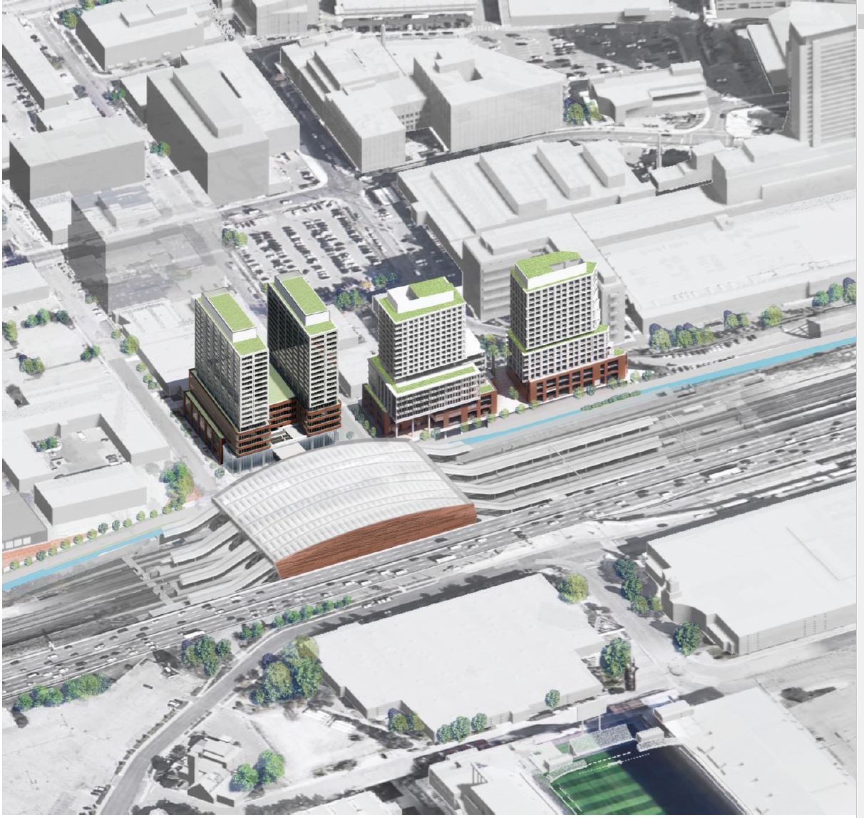
Today, the land is occupied by low rise industrial buildings and parking. To the north is the Liberty Village district with a mix of new condos and recycled industrial buildings. The Toronto Carpet Factory at King & Mowat is in the upper left corner. Immediately north of the rail corridor, the province has acquired the land for major redevelopment. Note that unlike other sites, this land is not needed for station construction. About 200 parking spaces are planned plus bike parking above the city’s target, but at an unspecified count.

The community presentation was organized as a walking tour with various stops along the way, and the numbers in the following slide headings link to that tour. I have taken selected parts of this, but leave it to readers to peruse the full version on IO’s website. The sequence is chosen to suit my narrative
A new street is proposed running along the north side of the rail corridor (yellow in the map below) east from Dufferin Street. For the time being, it is labelled “Liberty New Street”, but will no doubt get a different name as the project develops. IO is only responsible for the portion adjacent to the station but the street is intended to link from Strachan to Dufferin.
According to the record of the meeting:
… further coordination is underway with the City on the delivery of Liberty New Street, and it is hoped that it can be delivered in conjunction with transit infrastructure.
This is hardly a vote of confidence considering that they have eight years to accomplish this relative small part of the overall project.
This map also shows north-south connections to Exhibition Place. The western one, via the station building, would be above the rail corridor, while the eastern one is an expanded version of the existing tunnel.
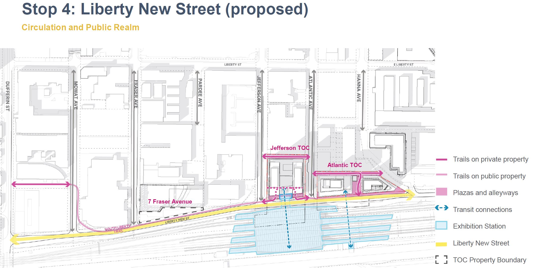
The map below, from the first consultation round, shows the planned circulation through the site. Note that there are two paths down from the bridge over the rail corridor landing in the space beside the Gardiner Expressway. With an expanded plaza under the expressway, it is unclear how the existing streetcar line could be extended west on its current alignment.
Also shown on this map is the location of a potential connector running south to Ontario Place (blue arrow in the lower left).

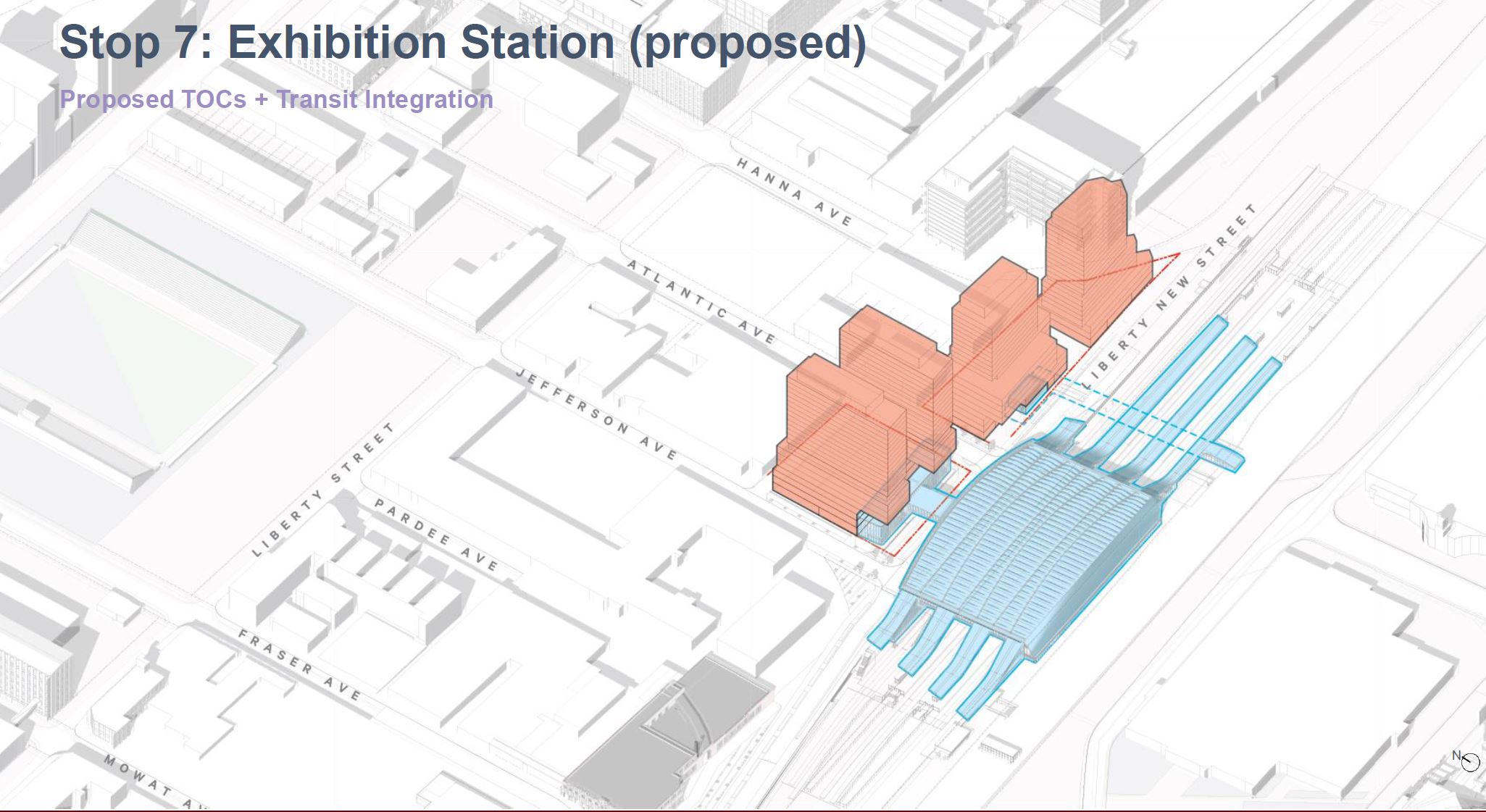
Another view shows the general massing of the proposed station and development to the north. The tunnel is outlined in dashed blue lines. It surfaces just west of the TTC’s Exhibition Loop. The presentation does not discuss how the proposed western extension of streetcars to Dufferin Street would interact with the new station. Planning work on that extension is currently on hold.
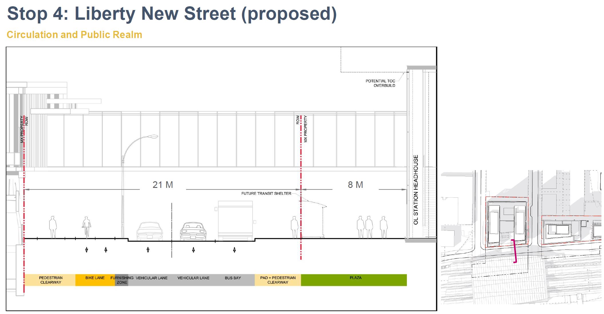
The cross section below shows how the station would relate to the new development and to the Exhibition to the south. The primary circulation would be at the “one above” level with the station entrance on the north side of the New Street.
Because of the perspective, the access south to Exhibition Place appears to go through the Gardiner Expressway, but it actually lies along the south side of the station in an east-west orientation as shown in the context map and circulation diagram above.

Further east, the existing tunnel would provide another crossing point and access to the GO/OL platforms.

The new street is in a constrained area, and is only planned to be three road lanes wide, plus cycling lanes along the south side. The first view below looks west with north to the right, while the second looks east with north on the left.
Transit service will access the station via the new street. The likely route is 63 Ossington based on the service frequency cited at the second consultation (4-5 minutes). There is provision for a double-length bus bay, but it is not clear whether the street would have service both ways, or act as part of a loop as Liberty Street does today for route 63.
During the same meeting, a question was asked about the Union-Pearson Express and whether it would stop at Exhibition. The people running the session did not even know that the UPX does not run on this corridor, and if it were going to stop anywhere, it would be on the new Liberty Village Station north of King Street. It was quite clear that the IO folks concentrate on buildings and don’t really know the transit side of these plans.

The design of the station and the buildings to the north take part of their style from the large number of brick-faced industrial buildings nearby, notably the Toronto Carpet Factory. Although the industries that were once here, built along the rail corridor, are long gone, Liberty Village is a major media and IT centre within some of the old buildings.
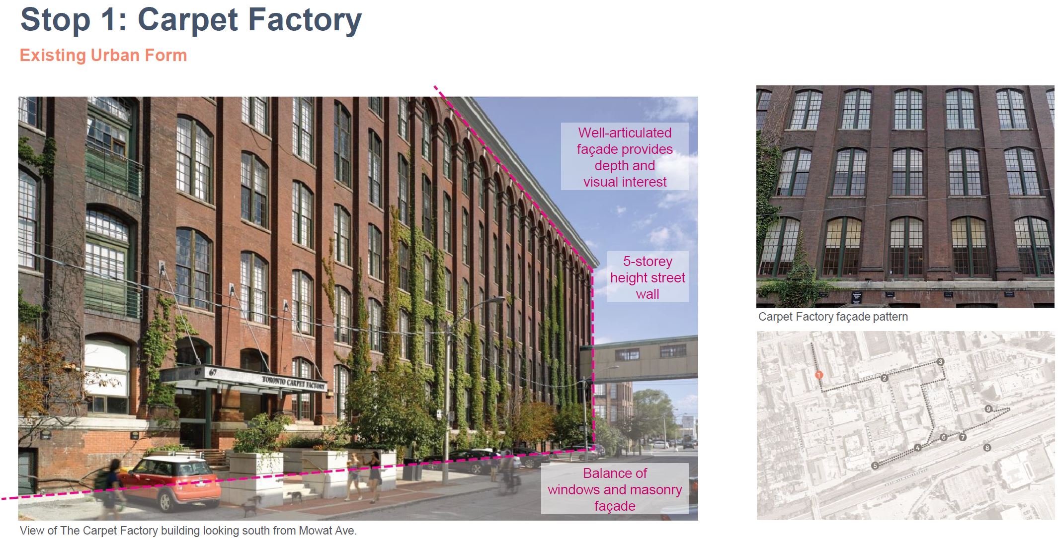
The diagrams below show where the proposed TOC developments will fit into the existing streetscape.
Although the red brick remains and provides some relief from the towers, there is no question that this is a major addition to an already-dense area at the south edge of Liberty Village. It is ironic that the developments proposed at Corktown Station on the edge of the original Town of York and the Distillery District do not show the same attention to their surroundings.
Unlike the plans for Corktown Station, Exhibition’s development does no include much if any space for community services. IO’s attitude is that this would be up to the city, and that constraints of their site make such features challenging (a statement from the second consultation session). There is a disconnect here and a sense that IO includes community features only when it suits them to placate the city.

Finally, the issue of noise from the GO corridor came up during a consultation session. Unlike the situation in Riverside on the Ontario Line, noise barriers are not an option here because this will be a high rise neighbourhood. The IO team’s response was that glazing on the buildings would be designed to limit noise, but this does not address what would happen if people wanted to open windows for fresh air.
The IO team made no mention of the planned electrification of much of the GO service before these buildings are even occupied, and the fact that the OL itself will be electric. It is, shall we say, disappointing when major government agencies cannot get their stories straight, and that the IO team is out of touch with important planned changes on the transit side.
Corktown Station
The Corktown Station site extends over two blocks from King Street south to the line of Mill Street and The Esplanade.
The existing neighbourhood is a mix of old and new buildings and styles.
In this drawing of the proposed development, north is to the upper left. The street running between the towers is Front Street East with Parliament Street to the east, and Berkeley Street to the west.
The Esplanade comes into the bottom of the frame just left of centre running into a park (for which expansion is planned as shown) and then Mill Street continues east of Parliament.

Here is a view from King Street. On the left is the view southeast at Berkeley, and on the right the view south from King through a proposed midblock pedestrian street.

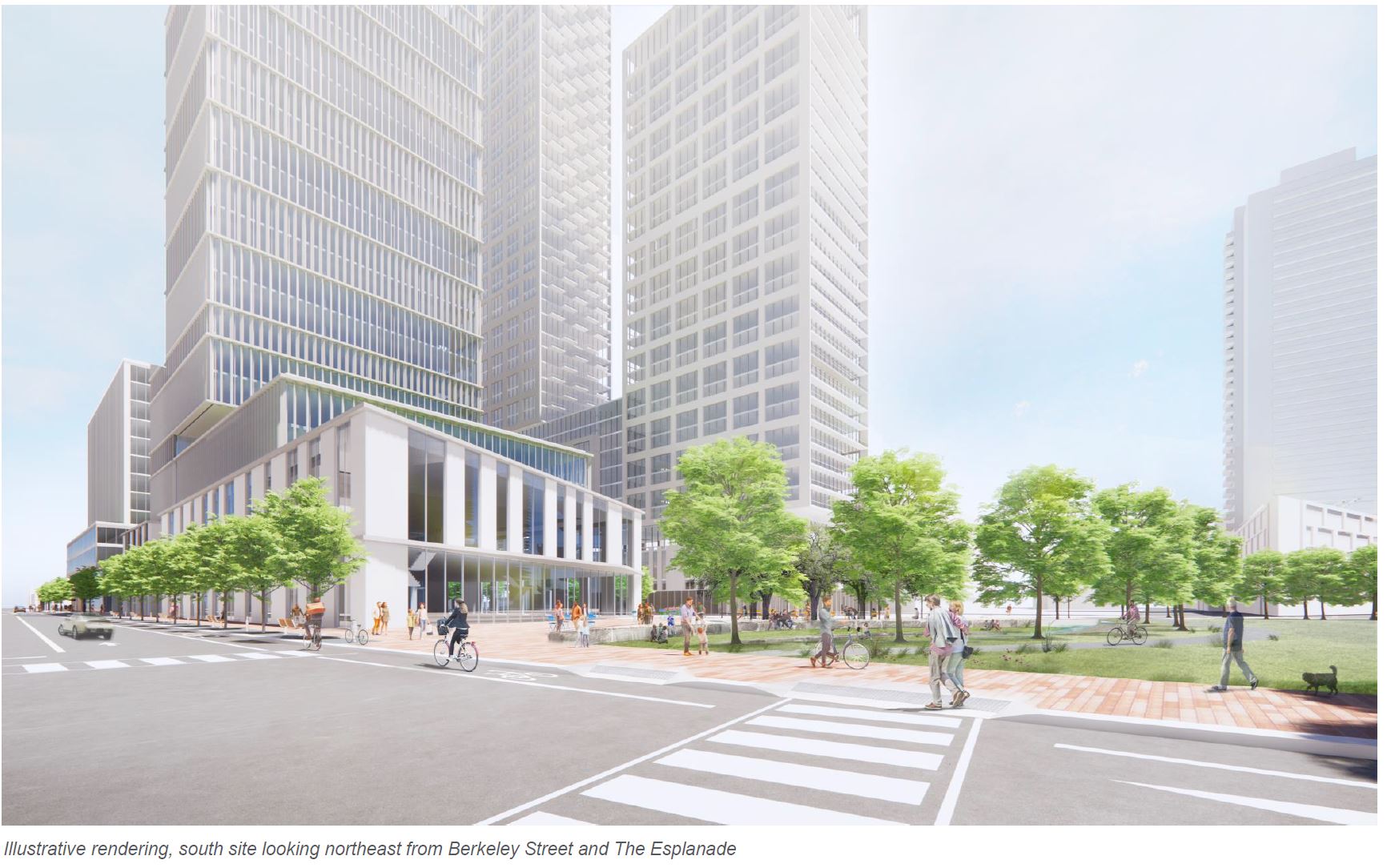
The south buildings seen from Berkeley Street looking northeast are shown below.
This cross section looks south through Corktown Station from King Street. Berkeley Street is at the right and Parliament Street is at the left. A former gas house now used as a police station appears in the left background.
Of particular note in this and other similar sections is the depth of the Ontario Line. It is not immediately below street level like many subway stations Torontonians know well. Transfers between the OL and surface routes will take longer at such stations.

The planned use of space within the North Site (King to Front) is shown here. It is a mix of office (mauve) and residential (yellow). This view looks to the northeast with the transit entrance on the southeast corner of King and Berkeley Streets.

The South Site includes residential and commercial space split east/west as on the North Site. There is substantial space for retail on the southwest corner and institutional (a library and community space) on the southeast. These will serve not just the new buildings but also other existing and planned ones in the neighbourhood.

Between the first and second consultations, changes were made to the proposal including:
- Parliament Square Park at the south end of the site has been expanded.
- The proposed massing of buildings has been adjusted to make room for the park.
- Library and Heritage Interpretation spaces have been incorporated
- Streetscape changes as shown below
During the second consultation, one participant noted that even at its “expanded” size, the park is still considerably smaller than what the city had planned for this area.

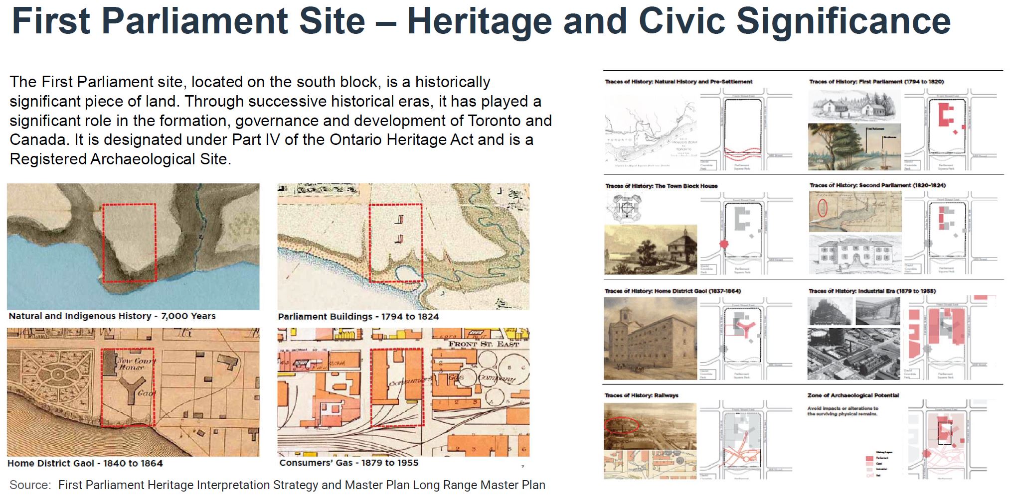
Although the site had no buildings of significance and has now been cleared, it is in a very old part of the city and once faced onto Lake Ontario. “The Esplanade” was not always land-locked. This is the site of Upper Canada’s (now Ontario) first Parliament building, and before that a site inhabited for millennia being close to the then-mouth of the Don River, an important water route. Provincial expropriation of this land, assembled first by the city, was a contentious matter, one of many along the Ontario Line’s route.
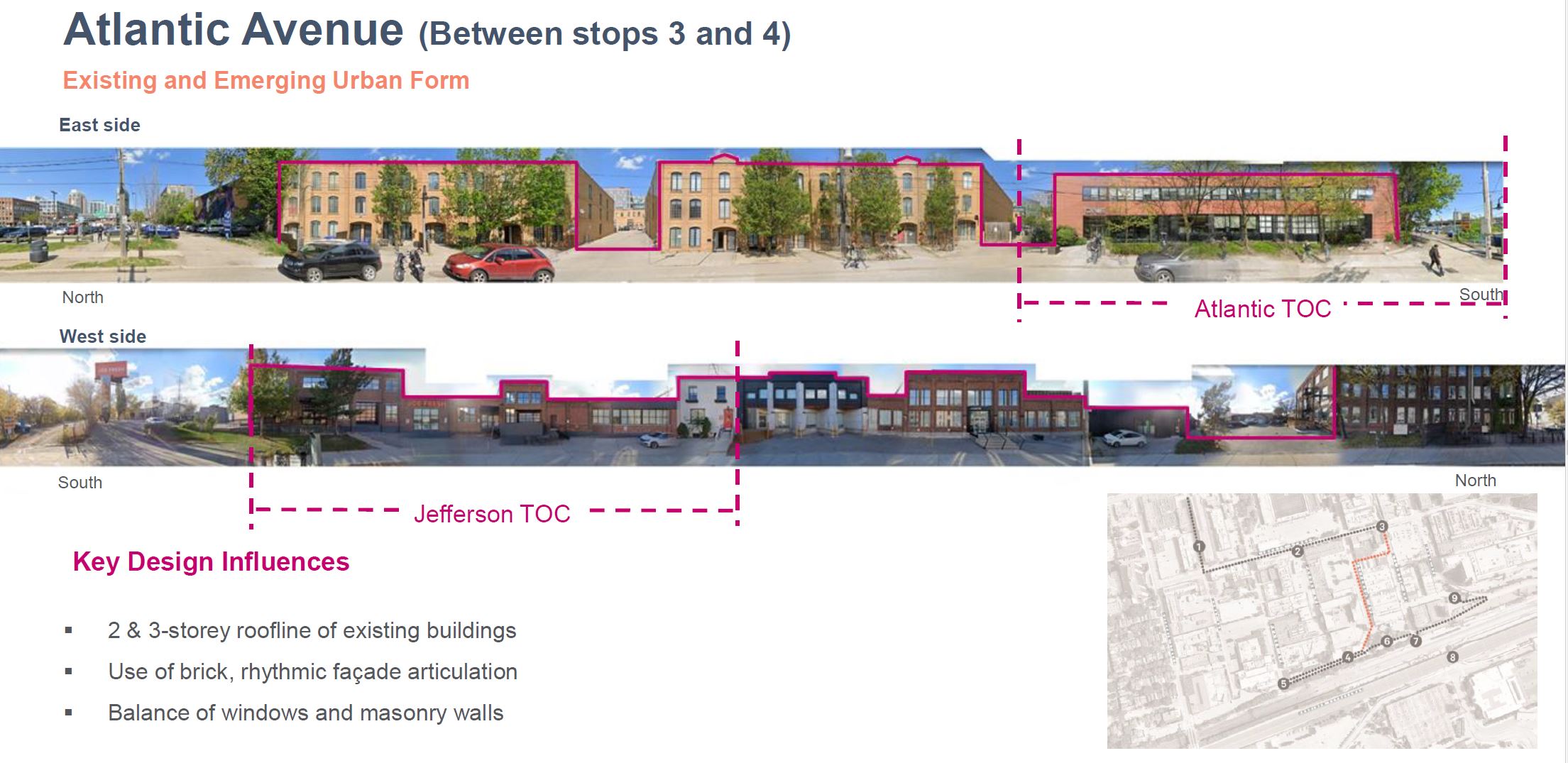
Many buildings in this area date from late 19th and early 20th century, but the proposed new towers echo more the style of modern buildings to the south and west. The tallest building in the collection matches the height of an as-yet unbuilt, but approved building on Parliament, west of the Distillery District just north of the rail corridor.

Many of the reference buildings cited are proposed or approved, not yet built. This is an example of the disconnect between the frame of reference people have today, and the one used by planners and developers to justify more large buildings. Some of them, such as 254 King East, are architectural monstrosities with boring new towers set upon hapless “historic” facades below, but they are used to justify more of the same.
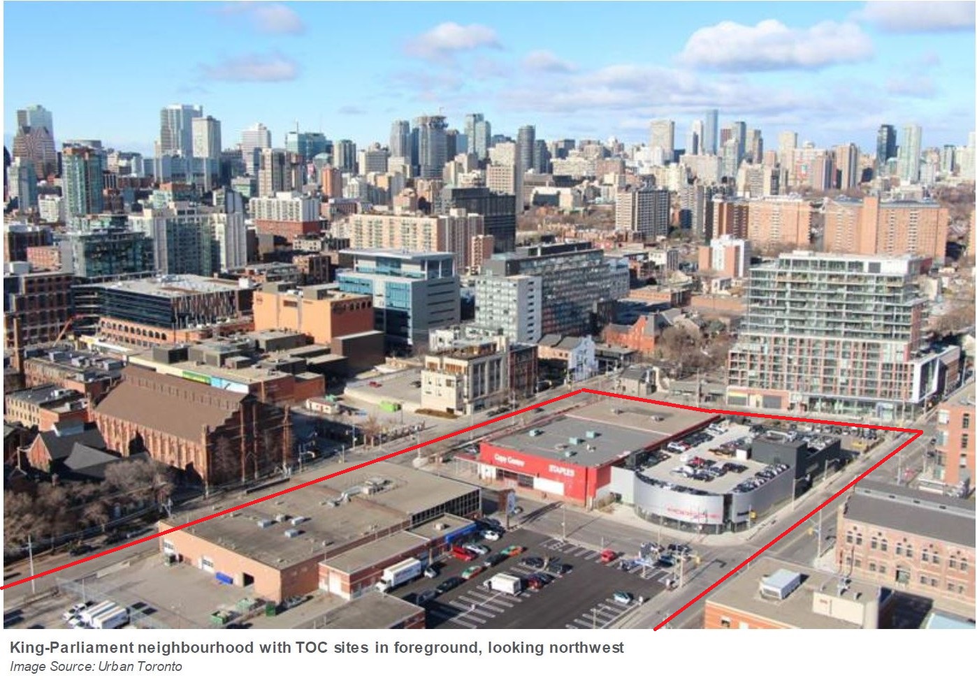
King-Bathurst Station
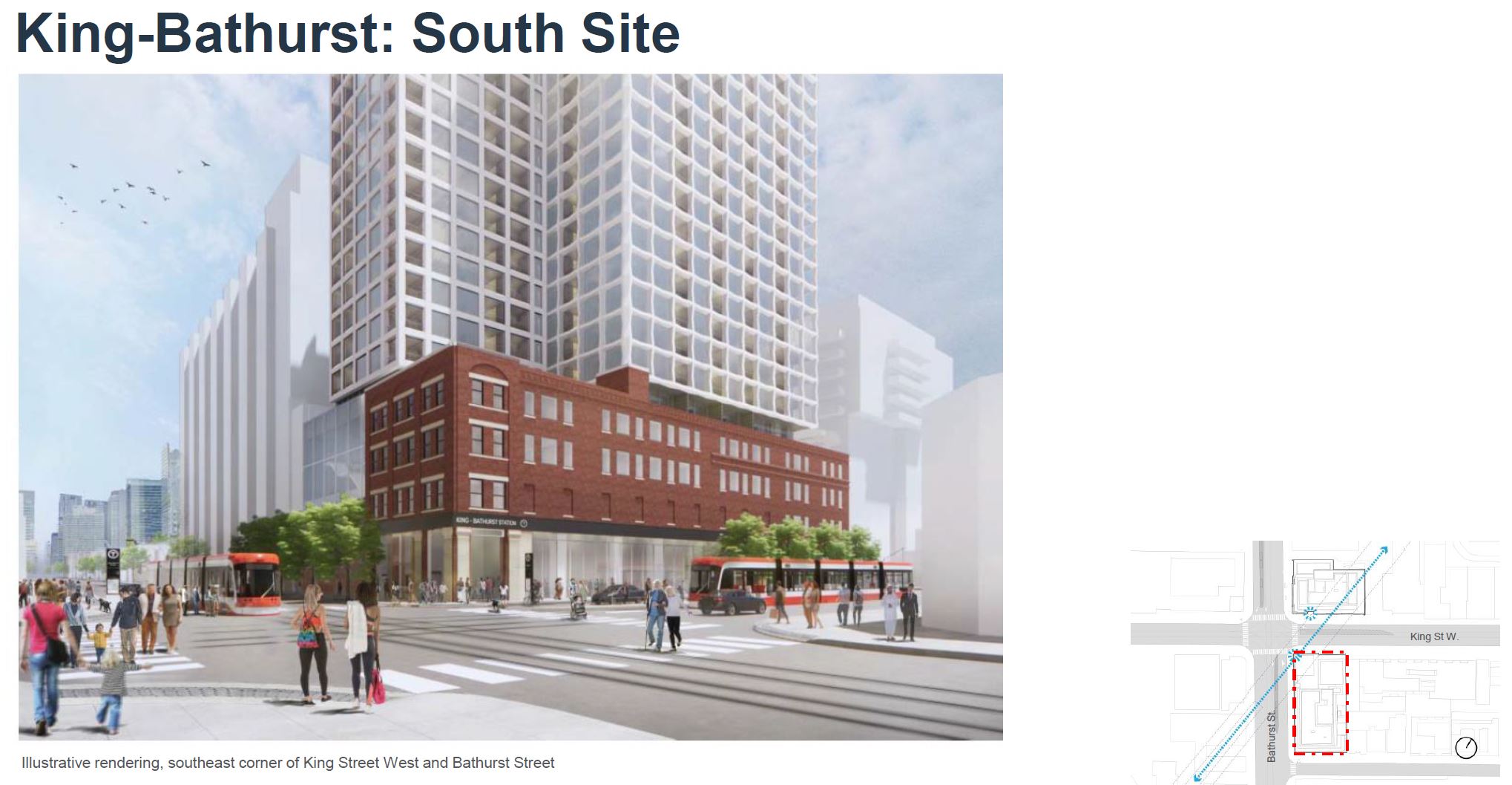
King-Bathurst Station lies on the diagonal path of the Ontario Line between the Exhibition and Queen Street. The tunnels will pass under the east side of the intersection avoiding the Wheat Sheaf Tavern on the west side. (That, by the way, would be a wonderful name for the station, if only the tavern, in business since 1849, can survive the construction activity.)
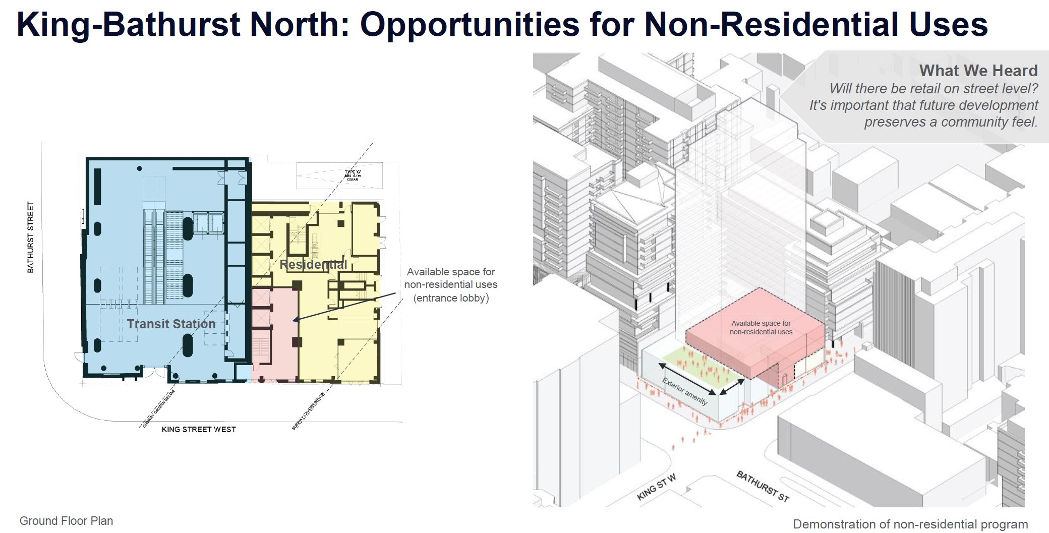
On the east side, two new towers will rise above the existing buildings. Both subway entrance spaces will be double-height. Remaining space within the old buildings will be laid out for commercial (north) and residential (south) use.
No parking for private vehicles will be provided under either building, but there will be lock-up areas for bicycles.

The area around King and Bathurst is a mix of old industrial and residential properties into which new development has spread west from downtown. There is a lot of red brick here, although it has been gradually replaced by the steel and glass of new buildings.

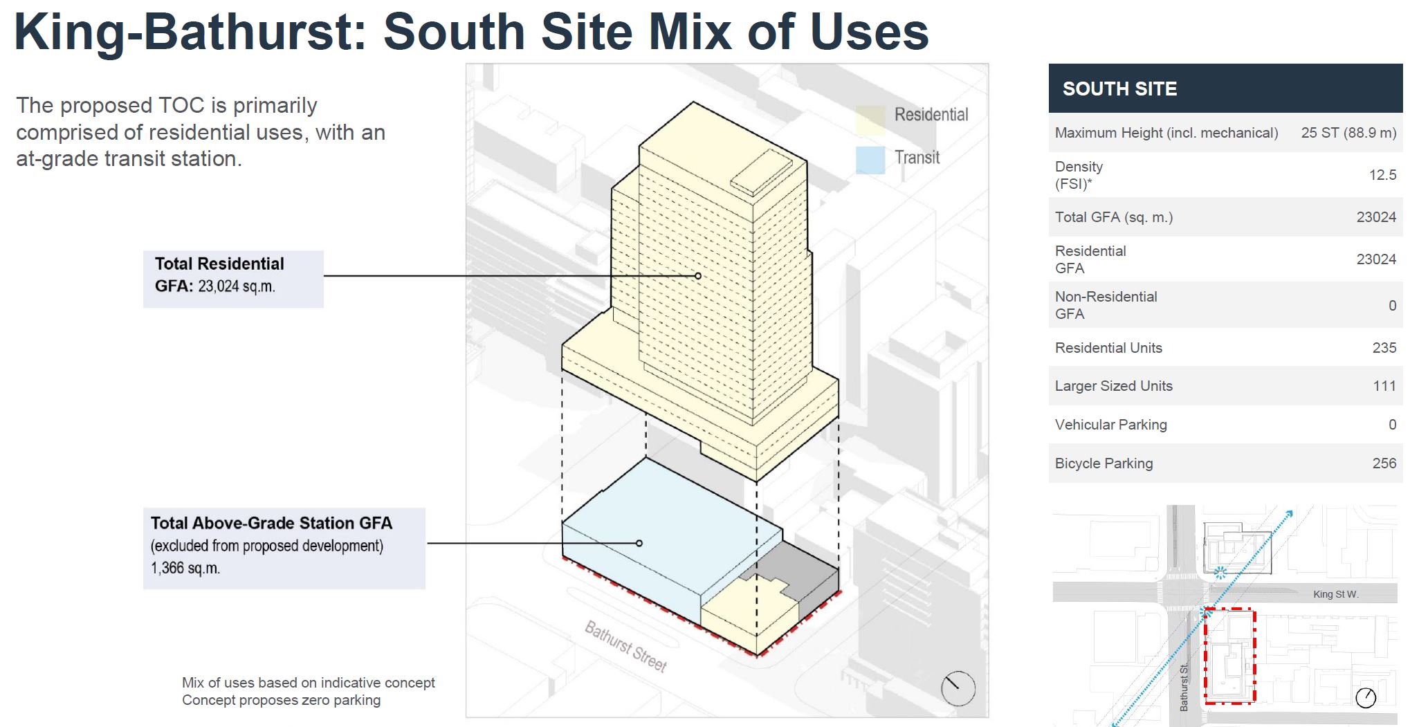
The illustration below shows other nearby developments including 64-68 Bathurst Street just south of the Wheat Sheaf. The numbers on the map indicate the height in storeys of these buildings, although the height for the planned TOC development on the southeast corner of King & Bathurst is erroneously listed as 17 rather than 25 storeys. Sites in red are completed, while those in yellow are proposed. The in between colours are approved or under construction.

IO speaks of making a transition down from heights in the core, but at 25 storeys the new buildings are taller than their neighbours and create a new peak in the terrain. What influence this will have on future proposals for the area remains to be seen.

The north building will perch on top of the existing structures leaving them to some degree intact. The exact details are hard to tell from the architectural plans on the IO site. The top of the west building is intended to be an amenity space as we will see below.

The south building will be retained, although this may only be a façade. Architectural plans show residential units following the existing window pattern on floors 3-4 of this building with several two-level, three bedroom units along Bathurst Street.
King-Bathurst is a centre platform station five storeys underground. It will be reached by stairs, escalators and elevators from the two entrance lobbies.

The drawings below show the streetscape for the northeast corner of King & Bathurst. The intent is that the westbound streetcar stop would be directly in front of the station entrance.

On the southeast corner, the station entrance will be beside the farside eastbound and nearside northbound streetcar stops.

The drawing below shows the mix of space usage planned for the north building. Most of it (yellow) is residential space with a small amount of non-residential space in the eastern part of the base.

As mentioned above, the roof of the station entrance building will be an extension of the third floor space (pink below) to the east. Possible uses cited by IO include a restaurant/bar patio or an outdoor play area for a daycare.
At grade level, it is possible that the transit station will not require as much space as shown here, according to IO, in which case non-residential space could be extended further west into what is now shown as part of the station.
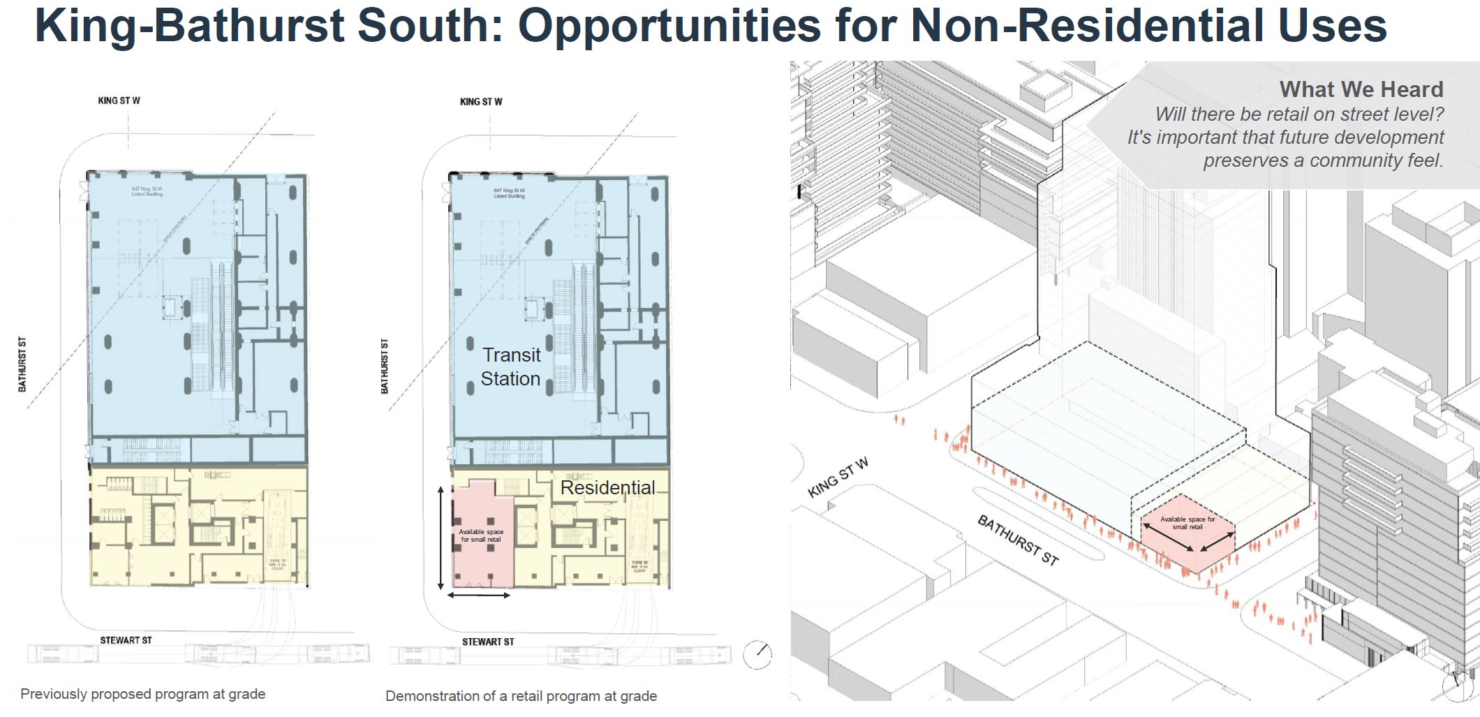
On the south site, as originally designed (below), there was only the station entrance and residential space above. This was changed as shown in the second drawing below to include provision for at grade retail space such as a coffee shop on the corner of Bathurst and Stewart Streets (pink below).
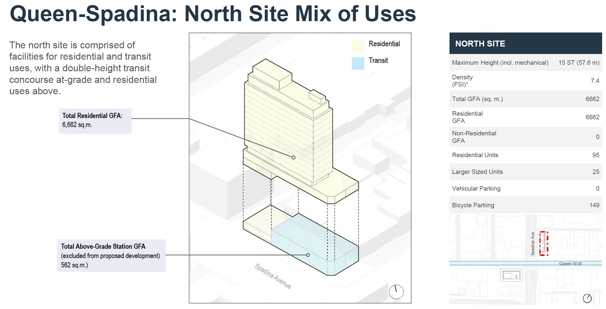
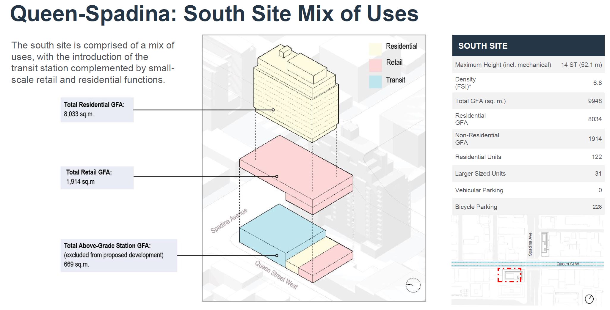
Queen-Spadina Station
As at King-Bathurst, the Queen-Spadina Station includes two TOC buildings and associated station entrances. At this point the Ontario Line is running straight along Queen Street five storeys below grade. Access from the entrance is provided by stairs, escalators and elevators.

The area around the station is a mix of existing and new buildings, although compared to King-Bathurst, there is more low-rise near the station notably the Queen West strip.

The area is changing, although development is less on Queen itself than neighbouring streets south and east. The map below shows locations and heights, in storeys, of recent and proposed buildings.

As at King-Bathurst, the new TOC buildings will form a peak at Queen-Spadina.

The north building will incorporate the façade of the existing Bank of Commerce, and the design is intended to mimic the bank’s decorative rhythm. With the tower set back from the sidewalk line, the intent is to preserve the low-rise feel of the street, at least for those close to the building.

On the southwest corner, none of the existing buildings will remain as they do not present a consistent frontage, and the corner is occupied by a relatively new TD Bank branch. The drawings below show an original (consultation 1) and revised (consultation 2) design with different surface treatments of the base building holding the station entrance.

The north entrance is on the street corner and will be a double-height space as shown in the cross-section. The station below has a centre platform accessed from a concourse above. The south entrance has a similar arrangement.

Except for the station entrance, the north building is entirely residential. There is no provision for vehicle parking, but bicycle parking is included.
The south building has a layer of retail space above the station entrance primarily on the 3rd and 4th floors. Above this is the residential portion of the building. As with the north building, there is no provision for vehicle parking.

Any talk of affordability beyond the usual platitudes about access to all in a city that is already overpriced, or do they consider that to be complaints from the rabble.
Steve: If you listen to the presentations, you will see that this came up in some of the Q&As. Infrastructure Ontario’s attitude to affordability is that the definition and the proportion of affordable units to be provided is a city matter. Given the long lead time from now to the point where these development plans will be locked in, it’s anyone’s guess what sort of government meddling might occur and what the targets, if any, will finally be.
LikeLike
At the Toronto Preservation Board today, the Chair proposed that Metrolinx be summoned to one of their meetings to discuss the Queen Station and why they have not, so far anyway, taken up the offer to put it below building on SW corner of Queen/University and NOT destroy the Osgood Hall ‘gardens’.
LikeLiked by 2 people
Again, we likely need at least two Relief projects, one on a triage basis for only lower Yonge ie. south of Eglinton, as Eglinton’s Line 5 will presumably open soon, bring in more people, and presuming a solid rebound in transit ridership, there’s nothing likely available, although we now have system slack, both systems, so yes, we can afford to re-set/re-design for a more surface-oriented, fast-trip/faster-done line.
But it’s occurring to me now, with the circles around the stations, that it’s the development that’s what’s driving the adjustment north to Queen St., with a whiff of ego at City Wall too.
All of the Ford government’s transit schemes aren’t really good enough for doing, and aren’t really investment, but Big Spendings, yes. And is it thus a boosting of private wealth with public spending? Again?
LikeLike
Ah yes, what is coming to be known as “façodomy.”
And someone should tell IO that bicycles are vehicles. This sort of frightening ignorance leads one to ask what other profoundly ignorant things are built into their designs.
Steve: Well, the buildings with zero parking spaces do have a lot of spaces for bicycles.
LikeLike
Hmm, bicycles…. WIth all this work from home, I wonder if the taxpayers/citizens would be much further ahead if we spent a billion buying OK electric bikes and gave them away to the citizens,with limiters on them for both speed and geography, so benefits/bikes stay in TO. If so, then maybe we could also convert half the garages in to housing, and fulfill the job boost aspect but far more locally and maybe lower cost. Bikes don’t work for everyone of course, and sometimes it’s decidedly ‘suicycle’ to be out there, though it’d help if the City would do plowing of snow out of bike lanes, not just in to them, as has at times/places occurred.
LikeLike
I hope that the Ontario Line will turn the areas around Danforth and Pape, Queen and Broadview, etc into high rise areas. Density is badly needed to justify a $15 billion underground line.
LikeLike
Speaking of limiting bikes and especially electric bikes based on geography, we need to keep them OFF of our bloody sidewalks. So many times I want to literally kick the cyclist or e-cyclist recklessly and unlawfully racing down the sidewalk putting us pedestrians at risk. I don’t understand why the good for nothing police don’t do anything to protect pedestrians.
LikeLiked by 1 person
Noting the various concerns/issues with the proposals – it’s good to see a transit project designed with TOD in mind (unlike the majority of stations on Line 5 Eglinton or the TYSSE).
LikeLike
I find it amusing to look at the street view of Danforth and Pape, or Queen and Broadview, and compare that with McCowan and Sheppard, site of yet another billions of dollars underground project. Apparently Canadian Tire has really high density already??
(I would post pictures, but I don’t think that’s possible.)
Steve: Here are the Google Street Views:
McCowan & Sheppard
Pape & Danforth
Broadview & Queen
I particularly love it when some troll shows complete ignorance of the development that already exists, and just tries to score points. Development will come to Pape & Danforth as a TOC project once the new station is built. Various developments are in the works in the Queen/Broadview area. Anyone can browse info about what has reached the application stage on the city’s Application Information Centre. Of course it’s easier just to throw insults than checking the facts.
LikeLike