Updated December 22, 2013 at 11:20 am:
Due to the winter storm and the shutdown of the streetcar system due to icing of overhead wires, the PCC shuttle today on Kingston Road has been cancelled.

Updated December 22, 2013 at 11:20 am:
Due to the winter storm and the shutdown of the streetcar system due to icing of overhead wires, the PCC shuttle today on Kingston Road has been cancelled.
The past two years at TTC and Council have been all about the fight over LRT and subways, and the shifting loyalty to each mode especially when potential votes are to be gained. While Toronto (and Queen’s Park) flailed about with expensive rapid transit plans, something more important, but more subtle, off the radar, was happening.
Discussion of the future of our transit fleet and service levels later this decade took a back seat in the triumph of ideology over planning. We are now in a position where all three modes — subway, streetcar and bus — will strain to meet demands placed on them for the foreseeable future. We will have very clean subway stations, but service and capacity are quite another matter.
The problems for each mode are different.
The Transit Investment Strategy Advisory Panel issued its recommendations on December 12. I have written a short review of them for the Torontoist, and will add more extensive comments here in coming days.
Updated on December 12, 2013 at 5:40 pm: Maps of the original SLRT alignment proposed by the Transportation Plan Review and the alternate alignment proposed by me and Robert Wightman have been added at the end.
Original article from December 10, 2013:
Back when glaciers still plied the northern outskirts of Toronto, there was something called the Metropolitan Toronto Transportation Plan Review. It was an outgrowth of the decision to halt construction of the Spadina Expressway and take a new look at Toronto’s transportation plans. At the time, folks living in The Beach and the east side of downtown were fighting against the Scarborough Expressway. This project would have linked the (former) stub end of the Gardiner at the Don east to Woodbine, north to the rail corridor, and then east to link up with the 401 in eastern Scarborough.
The MTTPR (as it was called) looked at alternatives to the expressway and in March 1974, they came up with a scheme to build an LRT line with two branches. This would follow Queen Street (as part of the streetcar service) to east of Broadview, then follow the rail corridor to Scarborough Junction. One leg would head east to Morningside, while the other turned northeast to the Scarborough Town Centre.
The Neptis Foundation has published a long report which provides a serious critique of projects in the Metrolinx Big Move plan and proposes significant alterations to the proposed network. Everything is based on cost-effectiveness although the critique depends on implementation of the overall scheme rather than the usual piecemeal approach to network expansion. Of particular note is the need to regard GO as a high frequency, high capacity regional system closely integrated with local transit.
There is too much in this report for me to comment on as I write this (midnight, December 11), but I will try to pull together more extensive remarks in the next day or so. Meanwhile, coverage of this report will appear in the Wednesday Star, and this is likely to stir up several hornet’s nests.
A quick review indicates the following significant issues:
At first blush, I cannot help thinking that this report is hopelessly naive on a few counts.
First, it depends on a co-ordinated scale of network expansion we are unlikely to see, especially for the GO component which is used to justify dropping other parts of the Big Move network.
Second, there is a focus on cost-benefit that at first glance appears to preclude the function of new transit lines as part of a network. A related issue is the question of marginal new ridership where a large expenditure to improve the quality of service for existing riders is given no credit for that benefit as they generate no net revenue.
Third, there appears to be no discussion nor appreciation of the role of local services for areas beyond the immediate reach of rapid transit stations. This is very much a return to the kind of thinking that infected early days at Metrolinx.
I will leave further comments until I have a chance to read all of the details.
Two studies came through Toronto’s Public Works & Infrastructure Committee at its November meeting revealing a less-than-coherent approach to traffic management and transit priority.
The Congestion Management Plan (CMP) takes a city-wide view with two background reports:
The Downtown Traffic Operations Study (DTOS) has a much tighter focus on the core area from Bathurst to Jarvis with a northern boundary of Queen Street, except between University and Victoria where it extends to Dundas Street. Background reports include:
Most striking about these reports is the fundamentally different way in which they approach their subject.
DTOS is very much about action, making specific changes “on the ground” to the way streets operate with the goal of improved capacity. This includes a more sophisticated form of Transit Signal Priority (TSP) that would take into account not just the presence of transit vehicles, but whether they were ready to proceed through intersections.
By contrast, the CMP spends a great deal of time talking about the need for technology upgrades and for co-ordination among various agencies – City Transportation, TTC, Utilities, Emergency Services – to the point one might ask if any of them ever talk to each other today and, by extension, how much “congestion” there is simply in agency-to-agency co-ordination. TSP gets pushed to the back burner here with a suggestion that it be granted only when vehicles actually need it, although how exactly that would be achieved given TTC’s chaotic approach to line management is anyone’s guess. More to the point, the TSP facilities now in place were funded by the TTC, but City Transportation now proposes to hobble their usefulness.
Updated December 9, 2013 at 2:00 pm:
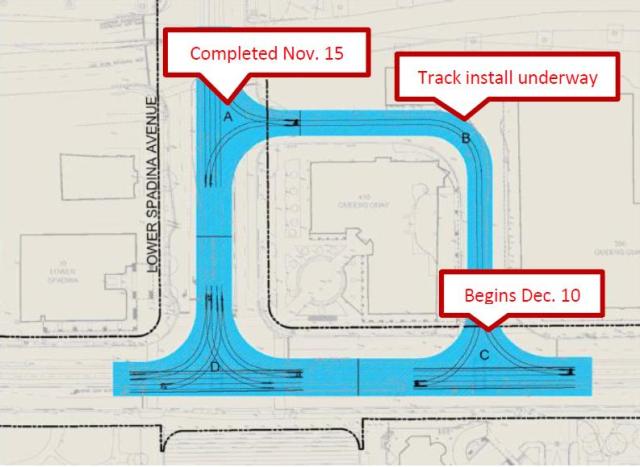
According to a Waterfront Toronto notice, reconstruction of the loop will move into Queens Quay proper on December 10 when work begins on the loop entrance (Section C below). Resumption of streetcar service is still planned for mid-February, 2014.
The TTC will make improvements in several routes in January 2014. Many of the changes are small-scale “tweaks” and we have yet to see system-wide benefits from the fare increase that will take effect on January 1.
The Service Budget does show some increase over past years.
January Vehicle Hours of Service Per Week

2010   159,288
2011   160,187
2012   160,830
2013   163,148
2014   167,118 (Budget, unchanged from Nov. 2013)
The values above do not include construction services, that is, additional vehicle hours required to accommodate construction projects which vary from year to year. Although some construction-related costs are charged to the capital budget, construction service takes buses and operators that are not available for regular service. In a year with many construction projects, this can delay the onset of service improvements elsewhere.
Despite budgetary constraints, the TTC was able to increase service in 2013 because its actual costs for 2012 were below budget. The 2013 subsidy was “flat lined” at the 2012 level, but the effect on an “as spent” basis was that the subsidy dollars rose in 2013, and the burden of additional service did not fall entirely on the farebox.
In 2014, there is a real dollar increase in the subsidy coupled with higher fares.
Route Changes Due To Construction Projects
504 King, 503 Kingston Road and 303 Don Mills Night Bus
Construction on the King Street approach to the bridge at the Don River will take longer than originally expected, and diversions will now remain in place until April, according to the TTC’s diversion notice.
72 Pape and 172 Cherry
Construction downtown has made for unreliable operation of the integrated service on Pape and its longer branch via Commissioners Street to downtown. Pending completion of the construction (mainly the work at Union Station), the route will be split.
72 Pape will operate from Pape Station to Cherry & Commissioners looping via Cherry, Villiers and Munition Streets.
172 Cherry will operate from St. Andrew Station to Cherry & Commissioners and will use the same loop as 72 Pape.
On Sunday evenings, matching existing schedules, there will be no service on 172 Cherry, and the 72 Pape route will terminate at Eastern & Carlaw.
97 Yonge
Water main repairs on Yonge Street between Finch and Sheppard will disrupt the 97 Yonge bus. The route will be split with overlapping services:
Midday service between Davisville and St. Clair stations will be discontinued.
Recent discussion about the Downtown Relief Line study and its Terms of Reference sent me back to the TTC’s Downtown Rapid Transit Expansion Study (DTRES) published last year for a look at the demand projections.
What I found there was rather troubling.
The TTC looked at three scenarios to model future shortfall in network capacity by 2031:
The demand model outputs appear in three separate tables within that study, but it is not until we consolidate the information that some anomalies really jump out.
There are four sets of numbers in this table with columns corresponding to the three model networks.
The capacity of the reference network is about 50% greater than the existing one. Note that for the northern GO services, ten-car trains are assumed although 20% could be added to the capacity with 12-car trains on the same presumed schedules. (The model also considered the east-west GO services and their effect in draining trips off of the BD subway that would otherwise contribute to demand south of Bloor Station.)
The modeled demand is also about 50% greater than the demand that the model assigns to the “existing” network configuration. This shows the modeled effect of increased transit service on network demand. However, this also begs the question of where those trips would be if the TTC and GO improvements did not take place. An obvious useful addition to the discussion would be the added road trips, or the trips simply not taken because there was no network capacity to handle them.
The big surprise is that there is almost no difference between the total demand with or without the Richmond Hill extension. Indeed, most changes are re-assignments of trips from GO lines and the University subway in the “reference” network to the Yonge subway in the “reference + YSE” network.
Route                    Without YSE     With YSE
University Subway           25,100        23,500
Yonge S of Bloor            35,800        39,400
Barrie GO                    7,500         7,400
Richmond Hill GO             2,500         2,200
Stouffville GO               8,600         8,000
Total                       79,500        80,500
Why would we spend billions of dollars building a subway to Richmond Hill to carry no more total riders on the network than we do without it?
There are two obvious responses to this question:
This is a rather strange situation considering that the holdup on building the Richmond Hill extension arose from the claim that it would overload the Yonge line. However, in the model, it does this primarily by attracting trips that would otherwise have been on GO or on the extended University subway.
(At this point, I have to wonder whether a similar methodology produced the inflated ridership projections for the Scarborough Subway, but that is another matter.)
The model shows very low ridership on the Richmond Hill line. Indeed, the greatest number of riders (2,900) is obtained with the “existing” network and the value falls even though GO service is improved in the “reference” and “reference + YSE” networks. This implies that the model prefers to assign trips to the “faster” Yonge subway especially when it goes all the way north to Richmond Hill.
On the BD line, although an increased capacity is included in the model (about 27%), ridership only goes up in the section east of Yonge. This implies either that demand from the west is static (difficult to believe) or that it is going somewhere else in the model. Where? Is growth assigned mainly to GO because it competes well with the subway for traffic in Mississauga while to the east Scarborough is poorly served by GO?
There is no question that Toronto needs more capacity into the core area, but the modeled numbers in the DTRES are suspect. If anything, they may understate the problem and the potential benefits of alternatives to stuffing more riders onto the Yonge subway.
The TTC has a long history of downplaying the need for anything beyond Yonge subway capacity expansion (more trains, new signals, bigger stations) to the detriment of long-term planning for better GO service and new TTC subway or LRT services. For many years, all we heard about from TTC was the need for a Richmond Hill subway. Any other project was cold-shouldered because it threatened that favoured scheme. Only when capacity problems could not be ignored did the TTC turn to the “DRL” as a possible solution.
Toronto has been ill-served by this blinkered planning, and coming studies on the future of the transit network (without regard to the paint scheme on the vehicles) must be based on a fair and accurate assessment of how new and improved services will contribute to moving passengers and limiting the growth of congestion in Toronto.
Updated December 4, 2013 at 7:00 pm:
Toronto’s Planning & Growth Management Committee considered the proposed consultation process from City staff regarding the Downtown Relief Line and approved it with only one minor amendment, that a contest be set up to name the new line.
Those of us who remember the last such contest will know that it produced, as a moniker for the line now serving Scarborough Town Centre, that heartwarming name, “RT”.
Two presentations were made by Metrolinx and by City staff.
The Metrolinx presentation gives an overview of the Yonge Relief Network Study which will consider capacity problems and approaches to relief from a network point of view including the possibility that some of the modeled demand can be shifted from the subway to GO Transit. Included in this is a map (page 4) showing the projected locations and degrees of capacity shortfall on the 2031 network.
What is quite striking about this map is that while there may be a severe problem south of Bloor Station, the situation north to Sheppard is not exactly rosy with demands ranging up to 100% of capacity. The need to divert demand north of Bloor is quite evident, although it is rarely mentioned in discussions of “downtown relief”.
The City presentation gives a précis of the report, but shows more clearly (page 10) that at this stage all that is happening is consultation on the Terms of Reference and the Public Consultation that would occur in a future study. This will come back to Council in the spring of 2014 for approval of the full study.
This is a hybrid version of the Environmental Assessment process. A Transit Project Assessment is intended to be fairly brief (120 days) based on a predetermined project. However, the DRL is so far-reaching and expensive a proposal that the City wants to ensure a valid review of all options has taken place before locking in to the formal TPAP review which offers little opportunity for amendment.
An important factor will be the co-ordination and integration of the network-wide study by Metrolinx and the local route and station planning by the City and TTC. Metrolinx will have a good sense of the network options by mid-2014 just at the point the City process enters its “alternatives” phase and the creation of a “long list” of options.
The greatest challenge in the short term will be to ensure that the Terms of Reference do not preclude options that should be considered. In this regard, limiting the study area to the initial phase of a DRL from downtown to Danforth may be valid for detailed planning of alignments and stations, but not from the larger view of how a second phase north to Eglinton or other extension options might affect the route selection on the first phase.
The City plans extensive consultation on the ToR including public input from community and advocacy groups.
Another challenge will be the credibility of demand and capacity figures used to model the future network. For reasons that I will discuss in a separate article, some of the modeling numbers cited by the TTC’s Downtown Rapid Transit Expansion Study are suspect on two counts:
If the numbers for the Yonge subway and the GO network are dubious, then what of the potential demand from a DRL, especially the component north of Danforth to which the TTC assigns a low demand and priority? Earlier at the same P&GM meeting, City staff presented information about the “Feeling Congested” consultations that have been underway. This included a preliminary evaluation of various additions to the transit network in which the Don Mills corridor, including the proposed LRT to Steeles, ranked highly (see map, page 19).
A future line cannot both be highly ranked and of little value, and this suggests at a minimum that the criteria by which it was evaluated are not the same in each case. The challenge for the DRL’s Terms of Reference process is to determine which evaluation is correct.
The original text of this article from December 2, 2013, follows the break.

