A Rainbow of Rapid Transit

In Toronto’s never-ending fascination with new transit maps, the City Planning department has released a vision for our rapid transit network as it will be in 15 years.

201602_15YrPlan

Despite much talk of “evidence-based” planning, this is a very political map, and I cannot help remembering then-Premier David Peterson’s announcement of 1990 (not long before he lost an election and Bob Rae wound up as his much-surprised replacement) that amounted to a chicken-in-every-pot map.

There is nothing wrong with network-based planning, and indeed I have been beating a well-worn drum on that subject for years. But let us also remember that the Scarborough Subway exists because of the political clout of Brad Duguid, a former City Councillor, now Ontario’s Minister of Economic Development. Mayor John Tory, in Toronto Life, cites Duguid as saying that “if anyone tries to cancel the [Scarborough] subway, they’ll do it over his dead body”. “Evidence” apparently includes having a large cudgel to keep wandering pols in line.

The map also includes the Mayor’s pet project, SmartTrack, and it’s no wonder that he steers clear of the Minister’s position given the need for a provincial agency, Metrolinx, to accommodate SmartTrack on their network.

All of this is part of the “Motherlode” of public consultation sessions now running in various places around the City, and through Metrolinx in the wider GTHA. Background information and links to related material are available at Toronto’s TransitTO web site.

Continue reading

Relief Line, SmartTrack, GO/RER, Scarborough Subway Consultations

Toronto City Planning has released a draft list of upcoming public consultations on various transit plans including:

  • The Relief Line
  • The Scarborough Transit Plan (Subway, SmartTrack, Crosstown East LRT)
  • The Western SmartTrack Plan (SmartTrack, Crosstown West LRT)

2016_ConsultationCalendar

Additional meetings and information about Metrolinx plans (GO Regional Express Rail) will be organized by that agency.

Even more information will be available in March 2016 when the City releases a compendium report on all transit initiatives currently under study. These will include items listed above as well as the “Waterfront Reset” study, TTC Fare Integration proposals and a review of how (or if) Tax Increment Financing can contribute to the many transit projects under review. The intent is that this report will form the basis for public consultation and debate leading to recommendations at Council in June 2016. This is a very aggressive schedule, and there is no indication how consensus will actually be achieved in so short a time, especially with the usually-secretive Metrolinx as an essential player. At least the discussion will be at a network level, not ward-by-ward with a “relief” line for every member of Council, and there will be some filtering of various schemes based on engineering and operational realities.

What is sadly missing from all of this is a discussion of day-to-day transit operations and the backlog in the state-of-good-repair budget. We can blithely discuss billions worth of subway building to Scarborough and a Relief line, but Council won’t fund the basics of running a transit system.

The Scarborough-Malvern LRT May Live Again

So much has been going on with the gradual disintegration of the SmartTrack plan and its replacement, at least in part, with elements from the Transit City network that it has been hard to keep up. I will write about this in more detail as reports and other information become available.

Meanwhile, there has been an interest on Twitter in the original EA documents for Scarborough-Malvern which vanished from view years ago in the anti-Transit City years.

I have created a repository for these files on my site.

Happy reading!

SmartTrack: Now You See It, Now You Don’t!

Oliver Moore in the Globe and Mail reports that there have been major changes to the SmartTrack plan, to wit:

  • The western branch of the service to the Airport district will be provided by the western extension of the Eglinton-Crosstown LRT as originally proposed.
  • “SmartTrack” per se will operate as a heavy rail service overlaid on GO Transit with the initial phase running from Mount Dennis to Kennedy Stations.
  • The northern extension of “SmartTrack” to Markham will be a separate phase of the project.

The map from the Globe & Mail is reproduced below.

GlobeSTLRTMap_20160114

According to Moore, the cost of adding SmartTrack to GO under this configuration would be much, much less than the originally quoted figure for the entire line. In turn, this would free up substantial capital spending headroom in City plans for other projects.

SmartTrack service at 15 minutes (the level proposed in Tory’s campaign) is far too infrequent to attract much riding, and especially to make a dent in demand on the existing subway interchange at Bloor-Yonge. We saw this in the June 2015 Metrolinx demand projections that were far more favourable to a Relief Line operating north to Sheppard and Don Mills. However, getting SmartTrack service down to as close a headway as every 5 minutes will be challenging for Metrolinx and for the corridors through which this would operate. There are no details yet on how this would be achieved.

The Eglinton West LRT has always been the superior way of serving this corridor compared to the heavy rail SmartTrack scheme. ST foundered on major problems with constructibility and neighbourhood effects, issues that were dismissed in a stunning display of cavalier “expert” knowledge during the campaign. Planning by Google Maps from an office in the UK has its limitations, but Tory’s campaign relied on this “expertise”. One shameless professor even rated ST with an “A+” in the CBC Metro Morning interview.

Keeping the first phase of ST confined south of Eglinton on both branches limits the operating costs the City must bear if this to be truly a “Toronto” project with “Toronto” fares, and it avoids the complexities of building into the 905.

Indeed, SmartTrack began as a real estate development scheme to make commercial property near the Airport and in Markham more accessible from downtown in a series of studies that actually claimed the market for downtown office space was static and falling. Yet another expert should be eating crow pie from his perch on the Metrolinx board. It was never clear why Toronto should shell out billions to improve property values in the 905, and this task now falls clearly to Metrolinx where it belongs.

The eastern leg of SmartTrack, north from Kennedy, obviously competes with the Scarborough Subway Extension, and there is no need for two routes serving the same demand, especially when GO already plans substantially improved service in the rail corridor. The long-standing issue of SSE demand may be clarified by the absence of SmartTrack as a competing service.

It is no secret that my own position would be to revert to the LRT plan in Scarborough, but that train has probably left the station, especially if the City can “save” a small fortune by scaling back on SmartTrack.

These changes could also foreshadow a revised schedule for the LRT projects at a time when “shovel ready” projects are in demand to soak up new federal spending. Eglinton West’s LRT extension is relatively easy to build, and it could be started soon enough to complete concurrently with the main Crosstown route. There is also the matter of the Sheppard East LRT including its proposed service linking to UofT Scarborough campus.

Coming weeks may bring many sputtering denials, or possibly, much improved clarity and acceptance of an – at last – realistic plan.


Eglinton Crosstown Station Names Settled At Last

After an extended discussion at its December 2015 Board Meeting, Metrolinx has decided on names for three stations on The Crosstown that were in dispute.

  • The station at Dufferin will be called “Fairbank”, as originally proposed, after the name of the original community.
  • The station at Bathurst will be called “Forest Hill”, as originally proposed. Although outside of the traditional centre of this community, the Bathurst/Eglinton intersection does lie on the edge of the borders of the original village.
  • The station at Lebovic/Hakimi will be called “Hakimi Lebovic” to recognize that the street changes name as it crosses Eglinton. Originally this was to be “Lebovic” station after the older and longer street of the two, and then the TTC Board, egged on by member Glenn De Baeremaeker, changed the name to “Hakimi” (the location isn’t even in his ward). Metrolinx adopted a “Solomon-like” decision to use a double name.

The Board held a teleconference meeting to discuss one item, the staff report on proposed names. The report proposed staying with the single name “Hakimi”, but this idea did not survive long in the rather short debate. Director Janet Ecker proposed “Hakimi-Lebovic” saying that this preserved some of “the integrity of the process”, but Director Bonnie Patterson wondered why this had not  been the original proposal.

The problem turns on the matter of a hyphen, and such punctuation offends the Metrolinx naming standards. The question of great import: to hyphenate or not to hyphenate? One director pointed out that the hyphen could indicate a link between the two families (as in a compound name), and this tipped the decision against the hyphen.

On a related note, all stations whose names are not already those of intersecting streets will get a subtitle, much as the stations on University Avenue have today, to identify the intersection they serve. Chair Rob Prichard suggested that people unfamiliar with their location could look at the signs on station walls to get the supplementary name, but subway riders will quickly tell you that this is not always possible depending on where a train stops and whether one can even see out of the window. There is also the basic question of access for those who cannot see easily or at all.

The entire exercise has the feel of massive face-saving for Metrolinx staff and the station naming protocols developed with much fanfare. The double name was described by Chief Planning Officer Leslie Woo as being in a grey zone, on the edge of the protocols. This is just plain silly. Many stations will have names that do not match the intersection they serve, and locations with different street names on opposite sides of a line are common (there are at least four on the Finch West LRT alone).

The protocols should be amended so that:

  • Double street names are allowed as station names where appropriate and where another option, such as a major nearby landmark or neighbourhood name, is not available.
  • Station “subtitles” should always be used to clarify a station’s location at a major cross street.

These “protocols” were not engraved in stone and they do not warrant worship as if they are immutable. Two basic issues were missed in creating them, and Metrolinx should be honest and humble enough to address this. “Nevermore” is not the correct answer in this circumstance.

Meanwhile, on a related topic, the actual name of the Eglinton-Crosstown name is still in debate given that the TTC has moved to line numbering. Will it become “Line 5”, or will someone complain that Toronto has scoffed all of the “premium” numbers for its rapid transit routes on a regional basis? At least GO Transit uses letters rather than numbers, and we can avoid a prolonged debate about who gets to use “Line 1”.

Such are the weighty matters that burden transit planners and politicians.

TTC Proposes Cherry Street Service Revision / Surveys Riders (Updated)

Updated November 26, 2015 at 2:30 pm: The TTC will be conducting a “Meet the Planners” session at George Brown College on Dockside Drive on Tuesday, December 1 from 2:00 to 4:00 pm. There has already been a similar session at Pape Station.

Route 172 Cherry was split off from 72 Pape a few years ago due to congestion from construction at Union Station. The question now is how to put the routes back together again, or indeed, if they should be in their original form.

The TTC has a survey active on its website until mid-December 2015 to poll riders on proposed changes to service mainly in the eastern waterfront.

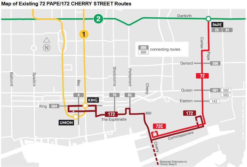
The current arrangement of routes is shown in the map below (taken from the survey):

MapExisting

This arrangement provides a fairly large loop through downtown and acts as a parallel service to the 504 King car for riders along The Esplanade and in the Distillery District. It was particularly useful during the recent Pan Am Games when service here was substantially improved because the route served the Athletes’ Village.

However, the connection between the 72C Pape and 172 Cherry services is not good. It is not a scheduled connection and the two routes operate on different headways. Moreover, the Port Lands is not exactly the best place to connect between routes at night or in bad weather. Splitting the routes also effectively eliminates a direct link from the Danforth subway to Queens Quay East and the Distillery District.

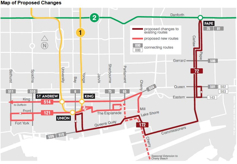
The new proposed route structure is shown below:

MapProposed

Route 72 Pape would be confined to the shuttle between Queen and Danforth, with route number 172 belonging to a revised Cherry bus that would operate via Queens Quay rather than using The Esplanade. The 172 would loop via Bay, Front and Yonge. It is unclear what the service level on 172 would be or whether this would be blended with the 72 Pape bus on the common section.

A new route 121 would operate on Front and The Esplanade between Parliament and Bathurst.

Service to the Distillery District along Mill Street would cease to exist, and the Distillery District would only be served at a distance by the 172 Cherry bus on Lake Shore and by the new 514 streetcar on Cherry itself.

The 514 car would operate from Dufferin Loop via King to Cherry Street, although given TTC scheduling, many of these cars could well short-turn without serving the outer ends of their route.

The 514 is less a new service for Cherry than a supplementary service for King, although this is not how it was presented in the 2016 Operating Budget. Indeed, provision of this map could have informed the discussion about streetcar service on Cherry considerably more than the way it was presented as a small spur off of King that would attract no new riders.

The survey itself is interesting because it asks, among other questions, whether this route structure would encourage people to use the TTC more. What is missing is a direct question about whether this arrangement is more convenient, not to mention any indication of service frequencies on which any discussion of “convenience” inevitably turns. There is a big difference between a line on a map and whether service is worth planning on and waiting for. One obvious question is whether the new routes – 172, 121 and 514 – would become part of the 10 Minute Network.

The survey claims that the new 172 Cherry route on Queens Quay would improve service to George Brown College (GBC), but it misses two important points:

  • The primary service to GBC, the 6 Bay bus, loads diagonally opposite from the likely stop for the 172 at Bay and Front. The option of taking whichever bus shows up first is not available to riders.
  • Similarly, westbound from GBC to downtown service would not use the 6 Bay stop within the loop at the college, but would speed past likely using the stop on Queens Quay well west of Sherbourne.

Looping through Dockside Drive in both directions, and a revised loop at Union Station should be considered if this is to be advertised as an “improvement” to GBC service.

The 121 bus as an alternative to the streetcar service on 509 Harbourfront only makes sense if it is quite frequent and reliable, not if this is a one or two bus shuttle showing up now and then for whoever happens to be passing by.

This is a good first attempt, but more thorough community feedback is needed than just this survey, and the TTC has to be more forthcoming about how each neighbourhood along the proposed routes would be affected.

Port Lands Planning Update

Waterfront Toronto, together with the City of Toronto and the Toronto Region Conservation Authority, are conducting several studies that will shape the future of Toronto’s eastern waterfront for decades to come. Recently, they held a series of open houses to outline the current status of their work and to solicit feedback. The materials from these sessions are available on the Port Lands Consultation website, and you can provide feedback through the “Discussion Questions” links.

This article deals primarily with the transportation component, given this site’s focus, but with some introductory material to set this in context.

Illustrations here are taken from five sets of display panels. Note that these are large pdfs.

Two large areas, the Port Lands and the “South of Eastern” district, are the subject of three studies in this consultation round:

  • A planning framework for the multi-decade redevelopment of these areas into the fabric of the city.
  • A transportation and servicing master plan.
  • A precinct plan for a new community to be called “Villiers Island”.

Other parallel studies affect this area:

  • The Don Mouth Naturalization and Port Lands Flood Protection Environmental Assessment (EA)
  • The Lower Don Lands Infrastructure EA
  • The Gardiner Expressway study
  • The SmartTrack and GO/Regional Express Rail (RER) study
  • The Relief Line study

Lest this seem like overkill and an undue focus on one area of the city, remember that the amount of land involved is equal to much of what we now call “downtown” between Bloor and the Lake. This is not a small area, and converting it from primary uses as a port and light industry to a much more mixed-used and higher density set of communities requires careful planning and a lot of infrastructure. Work on this has been underway for almost a decade, although it was almost derailed during the Ford era. Continue reading

TTC Budget Meeting: November 9, 2015 (Updated)

Updated November 10, 2015 at 6:00 pm:

The Budget Committee meeting was not the best-organized or well-informed of TTC meetings thanks to a combination of factors. It was held in the boardroom at TTC headquarters which is no longer configured suitably for such events and cannot handle a large presence by the media who were out in force anticipating a story about 2016 fares. Almost all of the material was presented by one person who, unfortunately, trusted to memory rather too often and got the odd fact wrong as the meeting wore on. Moreover, there simply was too much material to absorb in the manner it was presented.

Committee members, for their part, tended to view the situation through their personal lenses of which hobbyhorse needed attention. This did not necessarily make for a broad view of TTC issues, and many erroneous assumptions, often uncorrected, crept into the debate.

We will go through this and much more all over again at the November 23, 2015 meeting of the full Board when we can also expect a very long parade of deputations on the subject of fares.

The entire exercise of having a Budget Committee has been useful, up to a point, in that some Commissioners have been exposed to the gory details, but they remain confused, and we have yet to see an actual philosophical discussion of just what the TTC should be as a basis for the budgets for 2016 and beyond.

The following motions were approved by the Committee:

Continue reading

Eglinton Crosstown Station Names Update (Update 2)

Updated Nov. 17, 2015:

Although Metrolinx has yet to publish a report on the result of their consultation, it is clear that they have already decided on some changes to station names. This is revealed by a report for the TTC’s Board Meeting on November 23.

A proposed 2021 map (click map to expand) shows changes from the consultation information provided by Metrolinx (see original post below).

20151115_SystemMap

  • The station at Keele, originally proposed to be named “Silverthorne”, has become “Keelesdale”.
  • The existing Eglinton West station is to be renamed either “Allen” or “Cedarvale” (the TTC will pick one at its meeting).
  • The station at Avenue Road, originally proposed to be named “Oriole Park”, has become “Avenue”.
  • The station at Ferrand Drive, originally proposed to be named “Aga Khan & Eglinton”, has become “Aga Khan Park & Museum”.
  • The station at Bermondsey has become “Sloane”.
  • The station at Victoria Park, originally proposed to be named “Wexford”, has become “O’Connor”.
  • It is unclear whether the “& Eglinton” suffix has disappeared from all of the surface stop names because it was not included on the Metrolinx map either.

I will leave it to the trivia collectors to spot the stations shown as not accessible on this map where elevators are now under construction or well into the design stage.

Continue reading