SmartTrack: Now You See It, Now You Don’t!

Oliver Moore in the Globe and Mail reports that there have been major changes to the SmartTrack plan, to wit:

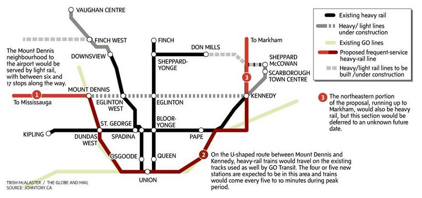
  • The western branch of the service to the Airport district will be provided by the western extension of the Eglinton-Crosstown LRT as originally proposed.
  • “SmartTrack” per se will operate as a heavy rail service overlaid on GO Transit with the initial phase running from Mount Dennis to Kennedy Stations.
  • The northern extension of “SmartTrack” to Markham will be a separate phase of the project.

The map from the Globe & Mail is reproduced below.

GlobeSTLRTMap_20160114

According to Moore, the cost of adding SmartTrack to GO under this configuration would be much, much less than the originally quoted figure for the entire line. In turn, this would free up substantial capital spending headroom in City plans for other projects.

SmartTrack service at 15 minutes (the level proposed in Tory’s campaign) is far too infrequent to attract much riding, and especially to make a dent in demand on the existing subway interchange at Bloor-Yonge. We saw this in the June 2015 Metrolinx demand projections that were far more favourable to a Relief Line operating north to Sheppard and Don Mills. However, getting SmartTrack service down to as close a headway as every 5 minutes will be challenging for Metrolinx and for the corridors through which this would operate. There are no details yet on how this would be achieved.

The Eglinton West LRT has always been the superior way of serving this corridor compared to the heavy rail SmartTrack scheme. ST foundered on major problems with constructibility and neighbourhood effects, issues that were dismissed in a stunning display of cavalier “expert” knowledge during the campaign. Planning by Google Maps from an office in the UK has its limitations, but Tory’s campaign relied on this “expertise”. One shameless professor even rated ST with an “A+” in the CBC Metro Morning interview.

Keeping the first phase of ST confined south of Eglinton on both branches limits the operating costs the City must bear if this to be truly a “Toronto” project with “Toronto” fares, and it avoids the complexities of building into the 905.

Indeed, SmartTrack began as a real estate development scheme to make commercial property near the Airport and in Markham more accessible from downtown in a series of studies that actually claimed the market for downtown office space was static and falling. Yet another expert should be eating crow pie from his perch on the Metrolinx board. It was never clear why Toronto should shell out billions to improve property values in the 905, and this task now falls clearly to Metrolinx where it belongs.

The eastern leg of SmartTrack, north from Kennedy, obviously competes with the Scarborough Subway Extension, and there is no need for two routes serving the same demand, especially when GO already plans substantially improved service in the rail corridor. The long-standing issue of SSE demand may be clarified by the absence of SmartTrack as a competing service.

It is no secret that my own position would be to revert to the LRT plan in Scarborough, but that train has probably left the station, especially if the City can “save” a small fortune by scaling back on SmartTrack.

These changes could also foreshadow a revised schedule for the LRT projects at a time when “shovel ready” projects are in demand to soak up new federal spending. Eglinton West’s LRT extension is relatively easy to build, and it could be started soon enough to complete concurrently with the main Crosstown route. There is also the matter of the Sheppard East LRT including its proposed service linking to UofT Scarborough campus.

Coming weeks may bring many sputtering denials, or possibly, much improved clarity and acceptance of an – at last – realistic plan.


Eglinton Crosstown Station Names Settled At Last

After an extended discussion at its December 2015 Board Meeting, Metrolinx has decided on names for three stations on The Crosstown that were in dispute.

  • The station at Dufferin will be called “Fairbank”, as originally proposed, after the name of the original community.
  • The station at Bathurst will be called “Forest Hill”, as originally proposed. Although outside of the traditional centre of this community, the Bathurst/Eglinton intersection does lie on the edge of the borders of the original village.
  • The station at Lebovic/Hakimi will be called “Hakimi Lebovic” to recognize that the street changes name as it crosses Eglinton. Originally this was to be “Lebovic” station after the older and longer street of the two, and then the TTC Board, egged on by member Glenn De Baeremaeker, changed the name to “Hakimi” (the location isn’t even in his ward). Metrolinx adopted a “Solomon-like” decision to use a double name.

The Board held a teleconference meeting to discuss one item, the staff report on proposed names. The report proposed staying with the single name “Hakimi”, but this idea did not survive long in the rather short debate. Director Janet Ecker proposed “Hakimi-Lebovic” saying that this preserved some of “the integrity of the process”, but Director Bonnie Patterson wondered why this had not  been the original proposal.

The problem turns on the matter of a hyphen, and such punctuation offends the Metrolinx naming standards. The question of great import: to hyphenate or not to hyphenate? One director pointed out that the hyphen could indicate a link between the two families (as in a compound name), and this tipped the decision against the hyphen.

On a related note, all stations whose names are not already those of intersecting streets will get a subtitle, much as the stations on University Avenue have today, to identify the intersection they serve. Chair Rob Prichard suggested that people unfamiliar with their location could look at the signs on station walls to get the supplementary name, but subway riders will quickly tell you that this is not always possible depending on where a train stops and whether one can even see out of the window. There is also the basic question of access for those who cannot see easily or at all.

The entire exercise has the feel of massive face-saving for Metrolinx staff and the station naming protocols developed with much fanfare. The double name was described by Chief Planning Officer Leslie Woo as being in a grey zone, on the edge of the protocols. This is just plain silly. Many stations will have names that do not match the intersection they serve, and locations with different street names on opposite sides of a line are common (there are at least four on the Finch West LRT alone).

The protocols should be amended so that:

  • Double street names are allowed as station names where appropriate and where another option, such as a major nearby landmark or neighbourhood name, is not available.
  • Station “subtitles” should always be used to clarify a station’s location at a major cross street.

These “protocols” were not engraved in stone and they do not warrant worship as if they are immutable. Two basic issues were missed in creating them, and Metrolinx should be honest and humble enough to address this. “Nevermore” is not the correct answer in this circumstance.

Meanwhile, on a related topic, the actual name of the Eglinton-Crosstown name is still in debate given that the TTC has moved to line numbering. Will it become “Line 5”, or will someone complain that Toronto has scoffed all of the “premium” numbers for its rapid transit routes on a regional basis? At least GO Transit uses letters rather than numbers, and we can avoid a prolonged debate about who gets to use “Line 1”.

Such are the weighty matters that burden transit planners and politicians.

TTC Proposes Cherry Street Service Revision / Surveys Riders (Updated)

Updated November 26, 2015 at 2:30 pm: The TTC will be conducting a “Meet the Planners” session at George Brown College on Dockside Drive on Tuesday, December 1 from 2:00 to 4:00 pm. There has already been a similar session at Pape Station.

Route 172 Cherry was split off from 72 Pape a few years ago due to congestion from construction at Union Station. The question now is how to put the routes back together again, or indeed, if they should be in their original form.

The TTC has a survey active on its website until mid-December 2015 to poll riders on proposed changes to service mainly in the eastern waterfront.

The current arrangement of routes is shown in the map below (taken from the survey):

MapExisting

This arrangement provides a fairly large loop through downtown and acts as a parallel service to the 504 King car for riders along The Esplanade and in the Distillery District. It was particularly useful during the recent Pan Am Games when service here was substantially improved because the route served the Athletes’ Village.

However, the connection between the 72C Pape and 172 Cherry services is not good. It is not a scheduled connection and the two routes operate on different headways. Moreover, the Port Lands is not exactly the best place to connect between routes at night or in bad weather. Splitting the routes also effectively eliminates a direct link from the Danforth subway to Queens Quay East and the Distillery District.

The new proposed route structure is shown below:

MapProposed

Route 72 Pape would be confined to the shuttle between Queen and Danforth, with route number 172 belonging to a revised Cherry bus that would operate via Queens Quay rather than using The Esplanade. The 172 would loop via Bay, Front and Yonge. It is unclear what the service level on 172 would be or whether this would be blended with the 72 Pape bus on the common section.

A new route 121 would operate on Front and The Esplanade between Parliament and Bathurst.

Service to the Distillery District along Mill Street would cease to exist, and the Distillery District would only be served at a distance by the 172 Cherry bus on Lake Shore and by the new 514 streetcar on Cherry itself.

The 514 car would operate from Dufferin Loop via King to Cherry Street, although given TTC scheduling, many of these cars could well short-turn without serving the outer ends of their route.

The 514 is less a new service for Cherry than a supplementary service for King, although this is not how it was presented in the 2016 Operating Budget. Indeed, provision of this map could have informed the discussion about streetcar service on Cherry considerably more than the way it was presented as a small spur off of King that would attract no new riders.

The survey itself is interesting because it asks, among other questions, whether this route structure would encourage people to use the TTC more. What is missing is a direct question about whether this arrangement is more convenient, not to mention any indication of service frequencies on which any discussion of “convenience” inevitably turns. There is a big difference between a line on a map and whether service is worth planning on and waiting for. One obvious question is whether the new routes – 172, 121 and 514 – would become part of the 10 Minute Network.

The survey claims that the new 172 Cherry route on Queens Quay would improve service to George Brown College (GBC), but it misses two important points:

  • The primary service to GBC, the 6 Bay bus, loads diagonally opposite from the likely stop for the 172 at Bay and Front. The option of taking whichever bus shows up first is not available to riders.
  • Similarly, westbound from GBC to downtown service would not use the 6 Bay stop within the loop at the college, but would speed past likely using the stop on Queens Quay well west of Sherbourne.

Looping through Dockside Drive in both directions, and a revised loop at Union Station should be considered if this is to be advertised as an “improvement” to GBC service.

The 121 bus as an alternative to the streetcar service on 509 Harbourfront only makes sense if it is quite frequent and reliable, not if this is a one or two bus shuttle showing up now and then for whoever happens to be passing by.

This is a good first attempt, but more thorough community feedback is needed than just this survey, and the TTC has to be more forthcoming about how each neighbourhood along the proposed routes would be affected.

Port Lands Planning Update

Waterfront Toronto, together with the City of Toronto and the Toronto Region Conservation Authority, are conducting several studies that will shape the future of Toronto’s eastern waterfront for decades to come. Recently, they held a series of open houses to outline the current status of their work and to solicit feedback. The materials from these sessions are available on the Port Lands Consultation website, and you can provide feedback through the “Discussion Questions” links.

This article deals primarily with the transportation component, given this site’s focus, but with some introductory material to set this in context.

Illustrations here are taken from five sets of display panels. Note that these are large pdfs.

Two large areas, the Port Lands and the “South of Eastern” district, are the subject of three studies in this consultation round:

  • A planning framework for the multi-decade redevelopment of these areas into the fabric of the city.
  • A transportation and servicing master plan.
  • A precinct plan for a new community to be called “Villiers Island”.

Other parallel studies affect this area:

  • The Don Mouth Naturalization and Port Lands Flood Protection Environmental Assessment (EA)
  • The Lower Don Lands Infrastructure EA
  • The Gardiner Expressway study
  • The SmartTrack and GO/Regional Express Rail (RER) study
  • The Relief Line study

Lest this seem like overkill and an undue focus on one area of the city, remember that the amount of land involved is equal to much of what we now call “downtown” between Bloor and the Lake. This is not a small area, and converting it from primary uses as a port and light industry to a much more mixed-used and higher density set of communities requires careful planning and a lot of infrastructure. Work on this has been underway for almost a decade, although it was almost derailed during the Ford era. Continue reading

TTC Budget Meeting: November 9, 2015 (Updated)

Updated November 10, 2015 at 6:00 pm:

The Budget Committee meeting was not the best-organized or well-informed of TTC meetings thanks to a combination of factors. It was held in the boardroom at TTC headquarters which is no longer configured suitably for such events and cannot handle a large presence by the media who were out in force anticipating a story about 2016 fares. Almost all of the material was presented by one person who, unfortunately, trusted to memory rather too often and got the odd fact wrong as the meeting wore on. Moreover, there simply was too much material to absorb in the manner it was presented.

Committee members, for their part, tended to view the situation through their personal lenses of which hobbyhorse needed attention. This did not necessarily make for a broad view of TTC issues, and many erroneous assumptions, often uncorrected, crept into the debate.

We will go through this and much more all over again at the November 23, 2015 meeting of the full Board when we can also expect a very long parade of deputations on the subject of fares.

The entire exercise of having a Budget Committee has been useful, up to a point, in that some Commissioners have been exposed to the gory details, but they remain confused, and we have yet to see an actual philosophical discussion of just what the TTC should be as a basis for the budgets for 2016 and beyond.

The following motions were approved by the Committee:

Continue reading

Eglinton Crosstown Station Names Update (Update 2)

Updated Nov. 17, 2015:

Although Metrolinx has yet to publish a report on the result of their consultation, it is clear that they have already decided on some changes to station names. This is revealed by a report for the TTC’s Board Meeting on November 23.

A proposed 2021 map (click map to expand) shows changes from the consultation information provided by Metrolinx (see original post below).

20151115_SystemMap

  • The station at Keele, originally proposed to be named “Silverthorne”, has become “Keelesdale”.
  • The existing Eglinton West station is to be renamed either “Allen” or “Cedarvale” (the TTC will pick one at its meeting).
  • The station at Avenue Road, originally proposed to be named “Oriole Park”, has become “Avenue”.
  • The station at Ferrand Drive, originally proposed to be named “Aga Khan & Eglinton”, has become “Aga Khan Park & Museum”.
  • The station at Bermondsey has become “Sloane”.
  • The station at Victoria Park, originally proposed to be named “Wexford”, has become “O’Connor”.
  • It is unclear whether the “& Eglinton” suffix has disappeared from all of the surface stop names because it was not included on the Metrolinx map either.

I will leave it to the trivia collectors to spot the stations shown as not accessible on this map where elevators are now under construction or well into the design stage.

Continue reading

A Smarter SmartTrack

The SmartTrack scheme was born of an election campaign, but it was John Tory’s signature project, one he is loathe to relinquish despite its shortcomings.

What’s that you say? I am just being one of those “downers” who cannot see our manifest destiny? What’s that line about patriotism and scoundrels?

At the recent Executive Committee meeting, Tory actually had the gall to say that during the campaign, he didn’t have access to a squad of experts and had to make do with the people he had. Funny that. This is the crowd that estimated construction costs on the back of an envelope, who “surveyed” the line using out of date Google images, who ignored basics of railway engineering and capacity planning to make outrageous claims for their scheme.

When the dust settled and John Tory became Mayor Tory, I thought, ok, he will adapt his plan. Indeed, it didn’t take long for a reversal on TTC bus service and the recognition that Rob Ford had stripped the cupboard bare and then started to burn the lumber at the TTC. A campaign attack on Olivia Chow’s (far too meagre) bus plan changed into championing the restoration of TTC service to the days of the “Ridership Growth Strategy” and beyond. Good on the Mayor, I thought, he can actually change his mind.

SmartTrack is another matter, and what Tory, what Toronto desperately needs is a fresh look at what GO, SmartTrack and the TTC could be if only the fiefdoms and the pettiness of clinging to individual schemes could be unlocked. That would take some leadership. I wonder who has any?

Inevitably comments like this bring out the trolls who say “so what would YOU do” (that’s the polite version). Here’s my response as a scheme that bears at least as much importance as a way of looking at our transit network as the competing visions in the Mayor’s Office, Metrolinx, City Planning and the TTC.

Continue reading

SmartTrack Update: Many Reports, Many Unanswered Questions (Updated)

Updated October 21, 2015 at 9:30 am:

The Executive Committee spent a few hours discussing this report. As the morning wore on, it was clear that Mayor Tory was becoming unhappy with questions about his scheme. By the end of the debate when he spoke, he said:

I think a number of the questions raised by members of council today are perfectly legitimate questions which I’m sure our staff have taken note of and if they weren’t already being asked and answered, those questions, they will now be.  I just hope and I sense a generally positive sort of sense around here but I hope that we don’t get into being either sort of Douglas or Debbie Downer about these things. [Adapted from a quotation in the Toronto Sun]

Tory went on to say that he had “a mandate” from voters to build SmartTrack in a manner distressingly reminiscent of Rob Ford’s “mandate” to tear up Transit City. The problem with both claims is that voters did not elect Tory or Ford for those specific purposes, but in a reaction against the previous administrations, particularly in Tory’s case. Moreover, that “mandate” does not mean that the platform necessarily made sense as proposed, only that it was an attraction to voters that a candidate had concrete ambitions. We have already seen Tory backtrack on his claims that Toronto did not need more bus service (responding to Olivia Chow’s half-hearted support for transit), and there is no reason for SmartTrack to be treated as a divine plan on stone tablets.

As answers from staff to various questions made abundantly clear, there is a lot of work to do between now and first quarter 2016 when all of the details are supposed to return to Council. Staff went out of their way to avoid giving any indication of the way preliminary work might be headed lest they be drawn into a debate about “conclusions” before the supporting studies are in place.

The Executive Committee made a few amendments to the report’s recommendations:

1.  Requested the City Manager to forward the report (October 15, 2015) from the City Manager for information to the Toronto Transit Commission, the Ministry of Transportation, Metrolinx, the City of Mississauga and York Region.

2.  Requested the Chief Planner and Executive Director, City Planning to report to the Planning and Growth Management Committee on the results of the public consultations arising from the Preliminary Assessments of the Smart Track Stations, as set out in Appendix 2 to the report (October 15, 2015) from the City Manager, particularly with respect to the development potential of new stations.

3.  Requested the City Manager to work with Toronto Transit Commission, Metrolinx, and GO Transit, to develop a One Map Strategy where by major intersections and/routes of these transit operators are shown on future hard copy and electronic local and regional transit maps, once SmartTrack routes and stations are established.

The first recommendation is the original staff proposal simply to transmit the update report to other agencies. The second arose from a concern by Councillor Shiner, chair of the Planning & Growth Management Committee, that implications of and potential for redevelopment around SmartTrack stations be understood as soon as possible. During debate, he spoke about the success of development a long the Sheppard line, an ironic stance considering how strongly he had opposed development around Bayview Station when it was at the design stage.

The third recommendation arose from Councillor Pasternak, who never tires of advocating the “North York Relief Line” (otherwise known as the Sheppard West extension to Downsview). His desire is that maps show all of the projects that are in the pipeline during studies, not just the one that happens to be the subject of debate.

A notable absence in the staff presentation was any reference to the Scarborough Subway Extension as an alternative route for travel to downtown. That presentation covered substantially the same information as the background reports, but it included a few new charts about comparative travel times with SmartTrack in place.

STvsTTC_TravelTimes1

The important difference between this map [at p23] and the Tory SmartTracker website (which shows comparative travel times) is that the TTC includes the access and wait times for SmartTrack in its calculations. This reduces the proportionate saving over a trip. Another issue, of course, is that many riders do not work at Union Station, and taking SmartTrack there would be an out-of-the-way trip. This is not to downplay what SmartTrack might do, but to point out that if ST is to be part of a “network”, then advocacy for it must look at how it benefits all of the trips originating in some part of the city (say northeast Scarborough), not just those that conveniently lie on its route. This will be an issue in comparative ridership projections for ST and the Scarborough Subway Extension because those who are bound for midtown will almost certainly have a shorter trip simply by taking the subway rather than ST.

The original article follows below:

Continue reading

A “Reset” For Waterfront Transit Plans? (Updated)

Updated October 15, 2015 at 10:20 am:

Because the options for the Waterfront West line are not fully explained or explored in the City report, I have added the drawings of the options from the Environmental Assessment to the end of this article.

A few weeks ago, I reported on a presentation at the TTC Board meeting by Deputy City Manager John Livey on the status of various rapid transit plans and studies. This was by way of a preview of reports that were expected at the City’s Executive Committee meeting on October 20, 2015.

One of these reports has now surfaced on the subject of Waterfront Transit, while another on SmartTrack is still in preparation. (Reports on the Relief Line and Scarborough Subway studies are not expected until the new year pending results from the UofT’s new demand model.)

The new report proposes a “reset” in the status of the many waterfront studies and proposals given that many of them are incomplete or out of date. The area of study will be south of Queensway/Queen from Long Branch to Woodbine, although there is passing mention of Scarborough which has its own collection of transit problems in the Kingston Road corridor.

The fundamental problem along the waterfront and areas immediately to the north is that population and plans for development continue with no end in sight, while transit planning, such as it exists at all, looked much further afield for signature projects. Moreover, origins and destinations in the present and future waterfront are not conveniently located along a single line where one scheme will magically solve every problem. Transit “downtown” is not simply a matter of getting to King and Bay. There is a mix of short haul and long haul trips, and a line designed to serve the first group well almost certainly will not attract riders from the second.

There has been significant growth in many precincts along the waterfront, including South Etobicoke, Liberty Village, Fort York, King/Spadina, City Place, South Core, and King/Parliament.  Further, significant growth is planned for emerging precincts, including Lower Yonge, East Bayfront, West Don Lands, North Keating, Port Lands and the First Gulf site.  There is currently a latent demand for transit south of Front Street as witnessed by transit loading on the King and Harbourfront streetcar services.  King Street, for example, represents the most southerly continuous east/west transit line and is regularly experiencing near or at-capacity conditions through much of the weekday peak periods.  The extent of latent and anticipated future demand creates an imperative for defining a long-term transit solution as soon as possible. [pp 1-2]

Better transit on King and Queen, whatever form it might be, will address demand from redevelopment of the “old” city north of the rail corridor, but it cannot touch the “new” city south to the lake. Service on the rail corridors (Lake Shore and Weston) can address some longer trips, but with constraints on both line capacity and service frequency. Despite politically-motivated claims, the GO corridors will not be “surface subways” with service like the Bloor-Danforth line, and GO service is constrained to operate through some areas that are not well placed relative to the local transit system.

Continue reading

Metrolinx Proposes Revised Names For Crosstown Stations

Metrolinx has proposed new names for several stations in the Eglinton corridor:

  • “Keele” to “Silverthorne”
  • “Dufferin” to “Fairbank”
  • “Bathurst” to “Forest Hill”
  • “Avenue” to “Oriole”
  • “Bayview” to “Leaside”
  • “Don Mills” to “Science Centre”
  • “Ferrand” to “Aga Khan & Eglinton”

Comments will be accepted by Metrolinx until October 7, 2015.

Updated October 2, 2015 at 9:30 am

201509_NewStationNames_ECLRT

Although the consultation affects only the stations listed in red in the list above, other changes are proposed including renaming “Eglinton West” to “Allen”.

The asterisk beside “Mt. Pleasant” is actually an error, and should be beside “Eglinton” because the proposal recommends a “change” from “Eglinton-Yonge”. Of course, the station isn’t called that yet.

Updated October 2, 2015 at 12:50 am:

The comments that have already been left on Metrolinx’ site suggest that many of their proposals are not exactly popular. I cannot help think that whoever is responsible for this report has a poor sense of Toronto (maybe another consultant who does all their work on Google Maps?), nor a sense of which neighbourhood names are actually used.

I cannot help think of the mystery surrounding stations at “St. Andrew” and “St. Patrick” that memorialized old ward/parish names that almost nobody knew fifty years ago, but which are now an inherent part of the city’s mental map of itself. Taking old names for an area may provide an historic link, but confuse people who have no idea of where these places are.

Of course we already have a precedent with Steeles West Station that has been renamed “Black Creek Pioneer Village” in reference to an attraction that is quite a distance from the station, and we almost got “University City” for Finch West.

Has anyone noticed, by the way, that this is called “Keele & Finch” in the “future” map in the report, “Leslie & Eglinton” is labelled “Sunnybrook Park” on the same map, and SmartTrack is nowhere to be found.