TTC Service Changes Effective Sunday, September 4, 2016 (Updated)

Updated August 15, 2016: The detailed table of service changes has been added to this article.

September 2016 will see a return to the “winter” schedules on most TTC routes. Despite talk of service cuts in the budget process, the new schedules include some improvements to correct for operational problems on a few routes, and to better handle existing demand. The scheduled mileage for September is actually above the budget level due to greater than anticipated requirements for diversions and extra vehicles to deal with construction projects.

2016.09.04 Service Changes

Continue reading

Travel Times on Queens Quay West

At a recent TTC Board meeting, the question arose of just how well Queens Quay operated as a transit street and how long it took the streetcars to navigate through the new setup.

Staff claimed that they had added six minutes to the schedule to compensate for problems, but this really didn’t give the full picture. Not to miss a chance to carp, Councillor Minnan-Wong latched onto this number and worked it into the debate at Council when the “Waterfront Reset” report was up for debate. The report passed without amendment, but the seeds of disinformation have been planted.

In the interest of clarity and accuracy,  rare commodities at City Hall, here is a review of what has actually been happening.

Continue reading

Council Approves Tory Transit Plan, Attempts Pet Project Revivals

Toronto Council has approved the transit plan for Toronto featuring Mayor John Tory’s SmartTrack line and the Scarborough Subway after a long debate on July 14, 2016. Notwithstanding severe problems with financial pressures and the blind faith needed to expect that the entire package can actually be funded, Council added a few pet projects that never quite fade from view thanks to the efforts of individual members.

LRT proposals for Eglinton East and West survived the vote largely because they are part of larger packages – SmartTrack in the west, and the Scarborough Subway Extension in the east. The subway debate has so polarized camps that “LRT” is synonymous with third class transit simply because it was the heart of the “non subway” option. Without the bitterness of the SSE that required subway advocates to paint LRT in the worst possible light, its potential role in Toronto’s future network might not have been so poisoned while other cities embrace this mode.

Staff recommendations in the report were amended in some respects, and a few new clauses were added, notably one asking for City staff to pursue a co-fare arrangement with GO Transit.

The Waterfront Transit Reset report is a separate agenda item and, at the time of writing, Council has not yet dealt with it.

The Finch West and Eglinton Crosstown LRT projects are under Metrolinx, and they are already underway to varying degrees.

Continue reading

Toronto’s Network Plan 2031: Part VI, Crosstown East LRT Extension

This article deals with the report Eglinton East LRT Preliminary Options Analysis which is before Toronto’s Executive Committee on June 28. It is part of a large package of transit proposals that have been discussed in several previous article in this series.

The Crosstown East, as it is now known, was originally the Transit City Scarborough-Malvern LRT line. It had fallen off of the map as part of the Transit City cutbacks imposed by Queen’s Park, but was resurrected early in 2016 as part of the “optimized” Scarborough network of a one-stop subway to STC from Kennedy, SmartTrack service in the GO Stouffville corridor, and the LRT to University of Toronto’s Scarborough Campus (UTSC).

With the recent announcement that the subway proposal will soak up more of the funding already earmarked for Scarborough than originally thought, the LRT line could be in jeopardy again. This would be quite ironic given that it was used as a sweetener to bring some members of Council onside with the one-stop subway plan. Indeed the LRT provides the majority of the benefit in the “optimized” scheme through its many stops close to residents who otherwise would not be on a rapid transit corridor. The package would not look as good for many of Toronto’s planning goals if the LRT line were omitted, but by bundling the stats, subway advocates can make the subway appear better than it would be on its own.

Of the reports before Council, this is the simplest of the proposals in that the options to be reviewed are quite similar differing only in whether the line would end at UTSC or continue north to Sheppard. The latter option dates from a time when it would connect to the Sheppard East LRT and a proposed carhouse at Conlins Road. Such a connection remains possible if Queen’s Park ever overcomes its aversion to LRT on Sheppard (or more accurately, its aversion to telling the Scarborough Liberal Caucus it will never see a subway extension there).

Continue reading

Toronto’s Network Plan 2031: Part V, Crosstown West LRT Extension

This article continues my review of the reports going to Toronto Executive on June 28. I will pick up the thread again just before the whole things winds up at Council in July.

Previous articles in this series are:

The report discussed here is

Continue reading

514 Cherry Opening Ceremonies

The 514 Cherry streetcar had its official opening on June 18, 2016, although regular service will begin on June 19 at 7:45 am. The route will operate between the new Distillery Loop near Cherry and Mill Streets in the Distillery District and Dufferin Loop at the western entrance of the Canadian National Exhibition grounds.

20160619Map514Changes

This is only the beginning of what should be a much larger network in the eastern waterfront, but work on that stalled thanks to the previous administration at City Hall. The impetus to restart on a serious basis will be funding of the Don River realignment and the active development of the land south of the railway corridor. Some idea of the potential network is shown in the following illustration from the Gardiner Expressway realignment study.

Cherry Street will be realigned south of the railway and will cross the Keating Channel on a new bridge including provision for streetcar track. New track along a realigned Queens Quay East will meet up at Cherry and provide the link to Union Station. Also shown (dotted) below is the proposed southerly extension of Broadview Avenue including streetcar track from Queen to Commissioners Street (out of frame below this illustration). Track on Commissioners would link east from New Cherry Street at least to Broadview and thence to Leslie Street and the southwest corner of Leslie Barns.

GardinerFig7HybridAlternative

For the occasion, five streetcars were on hand:

  • Flexity 4421, the newest of the cars in service
  • ALRV 4225
  • CLRV 4140
  • PCC 4500
  • Peter Witt 2766

4421 laden with many passengers and a few politicians set off from Distillery Loop after the usual speechifying such occasions bring, and made a round trip to Dufferin Loop. On its return, the original four cars were still waiting, but in due course the whole parade set off back to the carhouse.

An amusing note from our journey was that the car stopped at (and even announced) most of the stops along King Street that are scheduled to be taken out of service on June 19. This will be the only time that a 514 Cherry car served those stops. No, we did not have a photo op at each one to mark its passage.

Already there is word that operators are displeased with the absence of a loo at Distillery Loop. It’s a shame the Canary Restaurant isn’t still in business at Front Street where streetcars stop right at the door. I suspect this would have been a favourite layover point.

The TTC appears to be slightly confused about the location of the eastern terminus of 514 Cherry. According to the schedule website, this would be Cherry Beach Loop which is somewhat further south across both the Keating Channel and the Ship Channel, a lot sandier, and notably without any track. Not even any Swan Boats.

20160619_514_CherryBeachLoop


Scarborough Subway Ridership and Development Charges

The Star’s Jennifer Pagliaro reports that City Council has approved a confidential settlement with BILD, the Building Industry and Land Development Association, to avoid an Ontario Municipal Board hearing that could lead to rejection of the Bylaw implementing the Development Charges intended to pay for the Scarborough Subway. The matter was before Council in confidential session on June 7, 2016.

Staff miscalculations on the ridership of the Scarborough subway will leave taxpayers on the hook for millions more, after city council voted to settle a dispute with developers.

According to a secret report before council on Tuesday, the contents of which were shared with the Star, the city’s lawyers advised councillors to accept a settlement with the group representing developers, the Building Industry and Land Development Association (BILD).

The settlement, which reduces the amount builders will have to pony up to help finance the subway, is expected to cost the city as much as $6 million in lost revenues.

If the settlement is for only $6 million, the City should consider itself lucky because the calculation underlying the DCs is based on flawed ridership estimates and an out of date network design. Moreover, the original authorization appears to double count subway revenue with both a special Scarborough Subway Tax and Development Charges to recover the same costs.

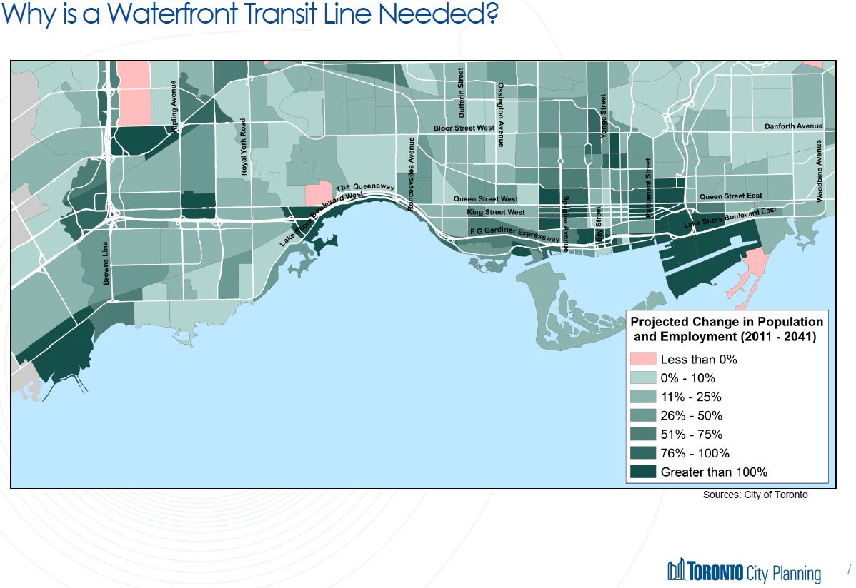
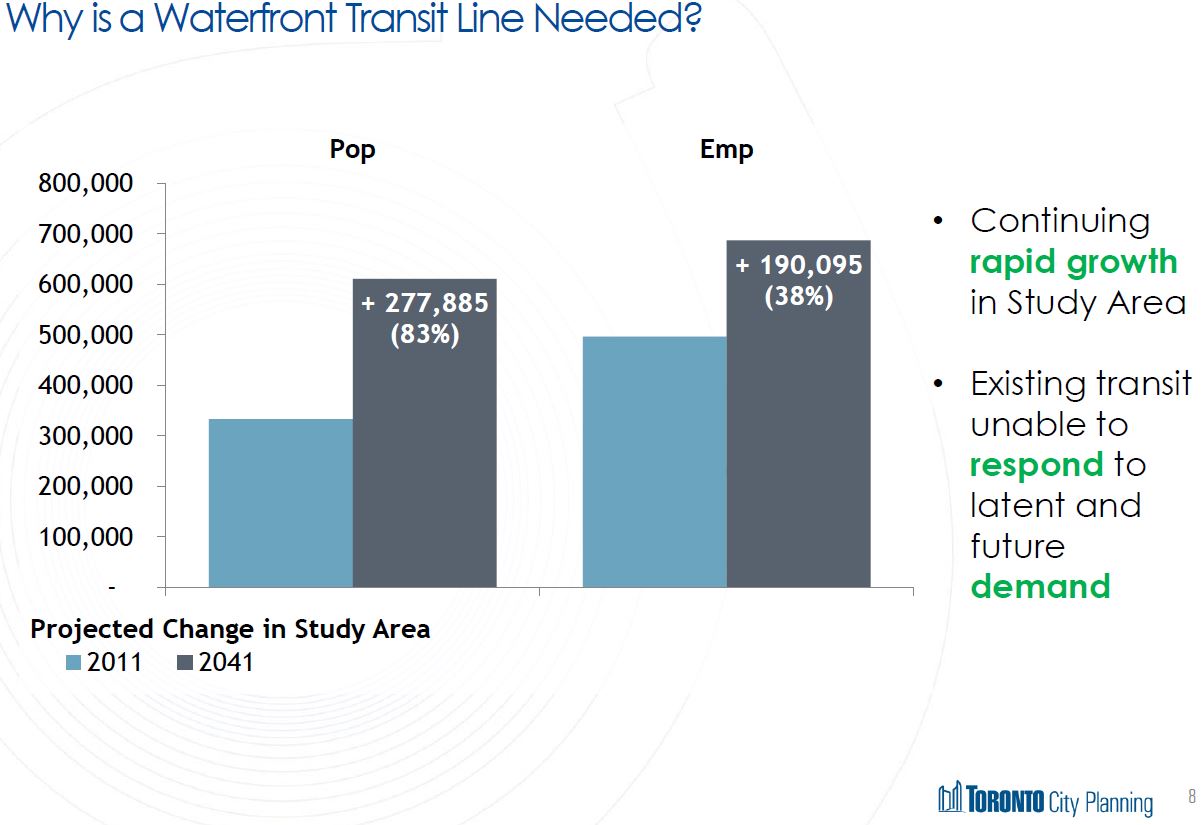
Recent news of a 50% reduction in expected Scarborough Subway ridership from 14,100 to 7,300 passengers in the AM peak hour reignited political debate on the viability of the subway scheme. However, these numbers are not just hypothetical indicators of how the line might perform, they are integral to the calculation of Development Charges (DCs) that would help to fund the City’s share of this project.

See also my previous articles:

The formula to calculate development charges is complex, but at its heart is one key measure: how much of a new transit project will benefit existing properties versus future development. If the primary role of a new subway is to improve the lot of current riders, then only a minority of its cost can be recouped by DCs (and thus from future purchasers of new properties).

Toronto allocates DCs on a city-wide basis rather than assigning each project only to the neighbourhoods it will directly serve. These charges already help pay for many projects as shown in the introduction to the study establishing the level of new charges for the SSE.

The Council of the City of Toronto passed a Development Charges (DC) By-law, By-law 1347-2013 in October 2013, for the recovery of capital costs associated with meeting the increased needs arising from development. The effective date of the Bylaw was November 1, 2013. The recovery of DCs is on a City-wide basis and relates to a wide range of eligible City services:

  • Spadina Subway Extension
  • Transit
  • Roads and Related
  • Water
  • Sanitary Sewer
  • Storm Water Management
  • Parks and Recreation
  • Library
  • Subsidized Housing
  • Police
  • Fire
  • Emergency Medical Services
  • Development-Related Studies
  • Civic Improvements
  • Child Care
  • Health
  • Pedestrian Infrastructure

For commercial property, there is some justification to this because increased mobility makes travel to jobs simpler well beyond the location of any one project. For example, the Scarborough Subway might be held out as a way to stimulate growth at the Town Centre, but it would also reduce commute times to other parts of Toronto, notably downtown.

For residential property, especially for the large proportion of new development downtown, this link is less clear, and DCs on new condos can wind up funding transit projects of little benefit to the new residents.

This split is part of the eternal battle between sharing the cost of public services across the city and charging them locally or by user group.

In the case of the Scarborough Subway Extension (SSE), the split between new and existing beneficiaries was determined by the change in ridership projected with the subway project. The benefit was allocated 61% to new development and 39% to existing riders. The ratio is high because, at the time of the calculation, the projected peak hour ridership for the SSE was estimated at 14,100 compared with a base value of 5,500. Both of these numbers are suspect.

The base value was factored up from actual SRT ridership of 4,000 per hour to 5,500 to represent the load the subway would have had were it to exist in 2015. That value of 4,000 is equivalent to a load of about 240 per train when the peak service was 17.14 trains/hour (3’30” headway) as in 2012. However, by 2013 service had been cut to 13.33 trains/hour (4’30” headway) to reduce equipment requirements on the aging line. That is the service operating today, although a further cut to 12 trains/hour (5’00” headway) is planned for June 20, 2016. Some of the demand that would be on the SRT travels via alternate routes, some is packed into fewer trains, and some has probably been lost to the TTC. What the ridership might be today were the RT not capacity constrained is hard to tell, but it should certainly be higher.

The high value for future subway ridership combines with the low value for presumed current demand to load much of the SSE’s cost onto new development.

The situation is complicated by two competing ridership estimates:

The contexts for the three estimates differ, and this goes some way to explaining why the numbers are so far apart:

  • A line to Sheppard will attract more ridership than one ending at the STC.
  • A subway station at Sheppard, in the absence of improvements to the GO corridor such as RER and SmartTrack, will attract ridership from Markham just as Finch Station does from the Yonge corridor north of Steeles.
  • Removal of the station at Lawrence East, coupled with new GO corridor services, will reduce demand on the subway.

There is no guarantee that the land use, job and population assumptions underlying the three estimates are the same, especially when the highest number was produced in the context of boosting the importance of STC as a growth centre.

What we are left with, however, is the likelihood that the level of DCs allocated for the Scarborough Subway project were based on the most optimistic scenario for new ridership, and a network configuration quite different from what will actually be built. If the calculation had been done on the basis of lower ridership numbers, the DC revenue available to fund the Scarborough Subway would have been considerably lower.

Continue reading

A Cat’s Cradle of Transit Plans (Updated)

Updated June 6, 2016 at 11:30 pm: The chart of the demand profile for the Eglinton East LRT has been updated by City Planning to correct an error in labelling where inbound and outblound values were reversed. The new chart has been placed into this post, and the link to the source pdf has been updated below.

Public consultation sessions are coming to an end on the “motherlode” of transit projects (as they were described earlier this year by Toronto’s Chief Planner, Jennifer Keesmaat). This process will soon bring a consolidated set of reports and recommendations for Council. So far, the presentations have been subdivided between various projects.

A major challenge for politicians, the media and the general public is to sort out all of these schemes and to understand how they all fit together. This is not just a question of how we will finance all of the projects, but of how each project and the choices made for it will affect everything else. Where typical studies in Toronto might have wrestled with whether a new line should go under street “A” or “B”, and where the stations might be located, today’s work requires understanding of how the network will evolve over time and how it will work as a whole in a few decades.

The process is complicated further by having municipal (City Planning & TTC) and provincial (Metrolinx) components, and the secretive nature of Metrolinx studies means that some vital information about its projects is not yet public. The Metrolinx reports are expected to appear on their Board’s agenda for June 28, and this implies public availability sometime in the preceding week.

The consolidated City reports should be available on June 21 when a briefing session is to occur at City Hall a week before the June 28 Executive Committee meeting.

Continue reading

A Messy “Reset” For Waterfront Transit Planning (Updated)

The first of two public meetings on the City of Toronto’s so-called “reset” of transit plans for the waterfront was held on May 25, and a second is to follow tonight (May 26).

The presentation deck from these meetings is now available online.

Updated May 27, 2016 at 5:30 pm: The preliminary evaluation grids for various routing options have been added to this article following the original discussion of each section of the study. This raises an obvious question of how options can be scored before important factors such as demand projections, design and costing are known, and whether the preliminary scores will bias the discussion and evaluations to occur in Phase 2 of the study. Scroll down to the end of each section for the additional material. (Apologies for the resolution. The grids are not available online, and I am limited by the quality of the paper copies distributed at the meeting.)

There is a lot of material to digest here, and the process is not helped by several factors:

  • Council has imposed a very short timeframe, considerably less than would normally be taken for the scope of work.
  • All proposals that have ever been on the table for the past few decades and a few new schemes are up for discussion, including some that should have been discarded quite early in the process. In part this is due to the many incomplete studies of various sections of the route that never got to the point of killing off the unworkable options.
  • The City and consultant staff presenting this material are not intimately familiar with the details of many proposals, nor with the history of how they came to be part of past studies.
  • Conflicting goals of previous studies, not to mention of today’s Councillors and community groups, make a “one size fits all” solution impossible.
  • Beyond identifying a few locations where GO/Metrolinx might add stations in the Lake Shore corridor, there is little discussion of the role GO/RER can and, equally importantly, cannot play in handling travel.
  • There is very limited origin-destination or demand information with which to validate or compare proposals, or to put them in the wider context of competing demands for transit funding.
  • A vital consideration for any network is the effect on travel times. After spending millions (or even billions), how would the speed and capacity of travel have improved?
  • The real meat of any discussion remains for an as-yet unapproved “Phase 2” study that would include [text taken from the presentation]:
    • Feasibility studies (including but not limited to demand forecasting, operational assessments, further developed cost estimates);
    • Potential Environmental Assessment(s) or amendments to existing Environmental Assessment(s);
    • Pursuing the implementation of short term strategic improvements that minimize long term throwaway costs; and
    • Advancing a Business Case and pursue funding opportunities.

As someone who has worked for years in hopes of better transit service to the waterfront, all of this is quite disheartening. So many competing ideas are on the table, so many competing priorities, and so little desire to spend pervades the discussion. We may end up with nothing at all.

Growth in the Waterfront

The need for better transit to many parts of the waterfront is quite obvious to anyone who looks at the forests of new condo towers along the water and neighbourhood close by to the north. Much of the projected population growth in Toronto is located in the southern part of the city (an area considerably bigger than the traditional “downtown”), but transit improvements there always come second (at best) to proposed expansion elsewhere. Where suburban subway boosters take a “build it and they will come” approach to subway advocacy and treat rapid transit as a trigger that will, they hope, bring new population and jobs, the waterfront already has both, and is growing apace without adequate transit support. Improved transit to the eastern and western waterfront rank in the top five performers of the City’s “Feeling Congested” study.

201605_PopEmpGrowthto2041

201605_PopEmpGrowthto2041_Chart

This growth will not all arrive “tomorrow”, but it certainly will build in over coming decades. Already, access by transit across the waterfront is inadequate, and this will only get worse as time goes on.

Continue reading

Spring and a PCC Arrive at Harbourfront

With Victoria Day weekend and the arrival of unquestionably late spring weather in Toronto, people are turning out in droves on Queens Quay: pedestrians, strollers, bladers, cyclists, streetcars and more than a few bewildered motorists.

The TTC will operate one PCC on Sunday afternoons from now through Labour Day weekend on the route. No fare is charged, and a free transfer is possible to the subway at Union Station.