
This article continues my review of the reports going to Toronto Executive on June 28. I will pick up the thread again just before the whole things winds up at Council in July.
Previous articles in this series are:
- Part I: SmartTrack
- Part II: Scarborough Subway Extension
- Part III: Fare Integration
- Part IV: Relief Line
The report discussed here is
Eglinton West
When is an LRT line not an LRT line? When it’s part of SmartTrack!
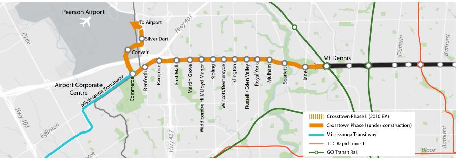
A bizarre aspect of the Crosstown West extension is that because it replaces the western end of the ST proposal, it still counts, at least in Mayor Tory’s mind, as part of ST for purposes of budgeting, area served, station count, etc. In other words, we will build something that is nothing like SmartTrack, uses a technology the Mayor rejected out-of-hand in the election campaign as a substitute for ST, but we’ve done a forgive-and-forget routine now, and so the LRT counts as part of “SmartTrack” implementation.
Recently, renewed interest has been taken in advancing rapid transit in the Eglinton West Corridor. The City of Toronto, in coordination with Metrolinx, is advancing the SmartTrack concept, which contemplates using the GO rail corridors to provide improved access for Toronto residents to rapid transit and to connect major employment nodes. A feasibility review of the SmartTrack Western Corridor, which coincides with the Eglinton West Corridor, has concluded that heavy rail would come at a high cost, have negative community impacts, and attract comparatively lower ridership to an LRT. In March 2016, Toronto City Council endorsed removing the heavy rail option for the Western Corridor in favour of further studying of the Eglinton West LRT by reviewing the Environmental Assessment to optimize the design. [p 1]
The Eglinton West LRT started out as part of Transit City, but was put on hold when Queen’s Park first took over that project and then downsized it to save on costs and to placate Mayor Ford. Now that SmartTrack’s line on Eglinton is acknowledged to be impractical, the LRT line is back on the table.
Travel in this area is to a mixture of destinations.
A review of current trip patterns for this part of the region using the Transportation Tomorrow Survey provides some detail about the number of trips to these key employment areas. For trips starting in Etobicoke, about 25% stay within the area, while another 25% are headed downtown or to destinations located to the east along Eglinton Avenue, 25% are headed north and south, and about 10% are headed to the airport area. The total number of trips originating in the area, bound for employment hubs is modest compared to other areas. For example, trips from Etobicoke to downtown and the Eglinton Corridor are about 12,300 trips, while from Mississauga to the same areas is about 19,500 trips. [p 2]
Moreover, trips to the airport and to the nearby Corporate Centre originate mainly from the west. The report puts this down to poor transit access from the east, but as so much of the travel in this part of the GTHA is car-based, it would be more accurate to simply say that the airport draws its employees more from the west than from much of Toronto. In this context, SmartTrack didn’t entirely make sense unless one believed that it could fundamentally rebalance the origin of work trips for the airport precinct.
The number of jobs in the airport area is quite impressive.
The ‘Transportation Study of the Pearson Airport Area,’ completed by Metrolinx in 2015, estimates that about 40,000 people are employed within the airport proper, and another 245,000 jobs are located in the surrounding Pearson Airport Area. Together, this makes up more than 280,000 jobs, which is more than the number of jobs in the central business districts of either Calgary (140,000 jobs) or Vancouver (145,000 jobs). By 2031, this number is expected to increase by 41%. More specifically, there are approximately 35,000 jobs within the Mississauga Airport Corporate Centre (MACC), and by 2041, another 10,800 jobs are expected for this sub-area. In addition to this, about 33 million passengers move through Pearson Airport annually. This number is expected to increase by 92% by 2031. [p 3]
The area is notiously hard to access by transit, and there is no such thing as a “short” trip to the airport. Moreover, employment is dispersed, and split across a municipal boundary leading to problems with provision of transit service. The modal split is not impressive, especially for such a large potential market.
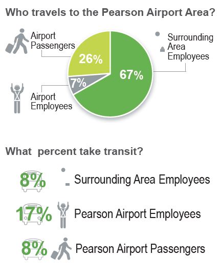
Projected demand on an LRT route in 2031 would come half from north-south bus feeders, 30% from Mississauga via the Transitway, and 20% from walk-ins.
When Metrolinx first began reviewing Eglinton West as part of the Crosstown project, they were still wearing a “regional” hat, and saw a line with several stops as an impediment to fast travel to the airport. More recently, their outlook has shifted to recognize that there is a local component to demand, and if the LRT doesn’t provide it, a parallel service will be required. The problem then becomes deciding:
- How many stops should there be – a tradeoff between speed and accesibility
- How much separation from traffic is appropriate – full grade separation like a subway, selected separations where traffic conflicts would be complex, or only segregation along the route with level crossings of cross-streets
- Which technology is appropriate – LRT (streetcars in their own right-of-way) or BRT (buses in a similar right-of-way, or possibly less)
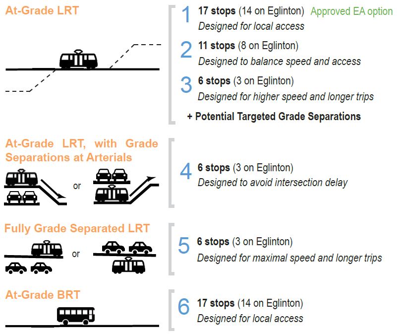
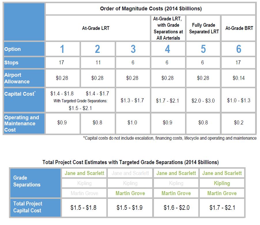
The variations Metrolinx review are summarized above. Full grade separation was rejected because of its high cost. The versions with targeted grade separations are favoured by the study.
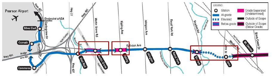
There are two options for the grade separation at Jane/Scarlett depending on whether:
- the structure takes a lower elevation and burrows briefly into the hill on the west side of the Humber River before emerging in a median portal west of Scarlett Road, or
- the structure takes a higher elevation continuing above Scarlett Road and then descending via a ramp into the middle of Eglinton.
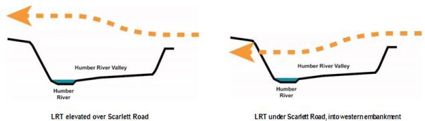
The need for such a structure is brought on by land availability.
Long protected for the construction of the Richview Expressway some land has been incrementally sold off by Build Toronto for development purposes while protecting for the EA design. Right-of-way width along the Eglinton West Corridor has become varied, potentially making it difficult to accommodate rapid transit within the existing road allotment that differs from the EA option. One key pinch point with private property is in the section between Jane and Mt. Dennis. For all options, it has been assumed that the connection through this area would be accomplished through an extension of the grade separated alignment from Eglinton Crosstown Phase I. Other segments along the corridor with insufficient right-of-way would require additional property acquisition much of which is already in public ownership. Several woodlots along the corridor are protected, and will require additional consideration as the design of the alignment is further refined. [pp 23-24]
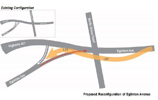
At Martin Grove, the LRT and streets would interlace to reduce conflict between road traffic especially with nearby highway interchanges.
Eglinton has substantial opportunities for development, but this brings a “catch 22” where development is most attractive when closer to a station. That is a basic limitation of schemes that would reduce the station could to provide a fast trip through the area – they would also reduce the number of points where people could access the service.
A key adjustment that may bolster the benefits of the LRT is a refinement in the number of stops along the corridor. The number of stops along a corridor, and the resulting distances between them, presents a trade-off between the ease of local access and faster journey times. Decisions about the number of stops will have to consider the numbers of riders that will be attracted to the service by the benefits of local access versus higher travel speed, striking a balancebetween these two opposing objectives. [p 11]
When Metrolinx looked at this in detail, the result ran contrary to their usual view of such things.
Given the value of longer distance trips for travelers across the region, an option with fewer stops appears to be more favourable in improving the economic case. Detailed analysis was undertaken for both 17-stop and 6-stop options, and suggested that some intermediate number of stops may be optimal as there is some ridership gain with moderate increase in stop spacing, and decrease in number of stops. While the 6 stop option creates larger stop spacings, and as a result, faster journey times, it provides limited local access along the corridor, which makes the services less attractive for some users. From the analysis, this effect was most evident in the eastbound direction of travel, where the benefit of faster journey times from the 6 stop option is superseded by the access benefits of having more stops. Ridership and benefits approximated for an intermediary 11 stop option resulted in a more favourable business case than both the 17 and 6 stop options, but more comprehensive analysis is still needed to identify an optimal number of stops due to the complexities of travel demand modelling on a local scale. [p 11]
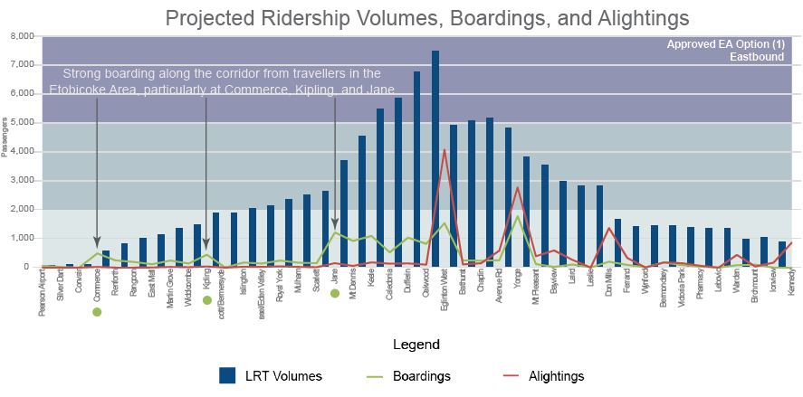
The travel pattern on the transit line mirrors what is seen on roads – more people are travelling west (57%) than east (43%) in the AM peak. Passengers destined for the airport receive the largest benefit in reduced travel time, probably because they have a service to their workplace that does not depend on a local distributor.
The eastbound ridership profile of the line shows how it is busiest between the Weston rail corridor and Eglinton West Station, with smaller buildups to Yonge and to Don Mills.
The choice between LRT and BRT comes out in LRT’s favour because it places the major transfer point between modes at the Renforth Gateway. If the Crosstown extension were built as BRT, the central part of the line would have to be extended west to Jane simply to reach a point where a transfer terminal was possible, and this would become an artificial node existing only as a place for riders to change vehicle.
Out of all the options, option 6, the BRT option, resulted in the most unfavourable benefit-cost ratio at 0.6. Although the cost of constructing BRT is significantly lower than LRT, this study has revealed that BRT would be much less suitable for meeting the needs of travellers in this corridor. As discussed in the strategic case section, a key factor influencing the suitability of either mode is the location of the transfer point. As the BRT option would be an extension of the Mississauga BRT, the transfer point between LRT and BRT would be located at either Jane or Mt. Dennis. However, because a greater portion of travellers travel westbound beyond this point, a transfer at either Jane or Mt. Dennis results in a disbenefit to a larger portion of travellers. As a result, the BRT option would only be able to attract a nominal amount of ridership compared to the LRT options. [p 20]
The details of the connection into the airport itself are not yet settled. When Transit City was first announced, the airport authority (GTAA) was stand-offish about letting an LRT into their lands. However, more recently there is a strong push for better transit to the entire airport area because the road system is filling up, and the potential employment growth cannot be achieved without higher-capacity transit service.
As the alignment on the Pearson Airport property has not yet been established, costs were not broken out into greater detail. Key decisions about the alignment of the route leading into the airport property will have to be determined before a more accurate estimate can be developed. For the purpose of this study, an ‘Airport Allowance’ of $0.28B was included in the capital cost estimates for all LRT options, while $0.14B was included for the BRT option. This estimate covers the segment of the project from the stop at Silver Dart Drive, where the EA approved alignment ends, to a terminus Toronto Pearson International Airport. Further work is required, in coordination with the Greater Toronto Airports Authority (GTAA), to determine the best way to provide access to the airport property. Metrolinx, the City of Toronto and major stakeholders are coordinating with the GTAA on the ‘Pearson Connects’ study which proposes significantly improving the accessibility of transit to Pearson Airport and its surrounding area. [p 18]
The total project cost varies from $1.5 to $2.1 billion depending on the options chosen.
The benefit cost ratios vary depending on the options, and I will leave it to the reader to dig through these in the report. Of note is the prevalence of “travel time savings” as a dominant factor, an analysis that rewards configurations that are more “express” in their nature.
The next stage of work will be to sort through the technical and organizational issues of bringing the design up to date.
1. Formalizing workplan and project coordination between Metrolinx, City of Toronto and the TTC
2. Further develop and study the options for targeted grade separation including consultation, refined analysis of costs and benefits and micro-simulation of operations
3. Detailed traffic analysis study following up on the 2009-10 EA to more fully understand the impacts and mitigation of different options on traffic operations
4. Planning and design work on the Pearson Airport segment with the GTAA and City of Mississauga
5. Continued consultation with the local community to understand benefits and impacts and share findings
6. EA amendment, if necessary [p 25]

Noticed that the Finch West LRT would have its Humber College stop below grade. The Eglinton West portion of the LRT could have the Martin Grove stop below grade, maybe the Kipling stop as well, and Scarlett Road & Jane above grade.
Why isn’t the Sunnybrook Park stop (AKA Leslie) above or below grade, or even moved to the south side at the intersection?
Steve: That was the subject of considerable debate and Metrolinx swore backward and forward it could not run side of the road through that section. I think they were telling porkies, but we’re past that decision now.
About the Scarlett Road & Jane section being above grade, will the Jane LRT go underneath the Eglinton LRT, or will it be at the same grade? If different grades, how will the connection between the two be designed?
Steve: And you still believe there will be a Jane LRT? I have no idea where it would go, let alone how one might link the two lines.
LikeLike
There is also the possibility that the Jane LRT will end at Eglinton with the legacy network providing service south of Eglinton. Mind you, we should finish one LRT line first before talking about lines that are nothing more than vague ideas at this point.
LikeLike
The few things I noticed:
1) The report says that 11 stops (about 1km apart) is the ideal, but they did not consider a fully grade-separated option with this stop spacing.
2) The fully grade-separated solution was deemed “from three to two times as costly as the surface LRT”, so it was ignored. The actual numbers show $1.4B vs. $2B to $3B – which is 1.4 to 2.1 times the cost. However, compared to the preferred solution, it is about 30% more.
3) The fully grade-separated solution has the best benefit/cost ratio.
Steve: The best cost-benefit ratio is not necessarily the best “solution”. Much of that so-called benefit comes from the imputed value of time and faster trips, not from real benefits such as actual service at stations. The Metrolinx model for this is badly flawed because it is set up to reward express services, and can’t deal with local service where goals may be different. This and other reports say that.
LikeLike
This line (and to a lesser extent the Crosstown East as well) really drive home the importance of some kind of regional fare integration. I believe that this will be the first direct connection between two local rapid transit lines in the GTA. Many of the commuters on the Transitway or on the LRT may have to transfer from one to the other but only for a very short distance to access jobs. If transit is to be the preferred choice, these people cannot be forced to pay double fare. There is an opportunity here to build a very good, integrated transit system to serve the airport district from multiple directions. I hope it isn’t bungled.
LikeLike
If there were enough will, then it can still be grade separated either by ducking under, above, or best of all by moving it to the south side. Metrolinx offered to tunnel until Wynford Drive where it would surface but the good people who live at Eglinton and Leslie wanted a stop right at the intersection as too much walking is bad for their health and the stop was too expensive to build underground. But wait a minute, the good people who live at Eglinton and Leslie? There are no good people living there as there is no one living there except a few tourists who stay at the hotel there for a few days and who, however good they may be, don’t care about any of this as they are tourists and gone with the wind tomorrow.
So, most of those people who insisted on a stop right at the intersection will be arriving there by bus anyway and the southbound buses on Leslie will have to go a little bit east or west at Eglinton anyway and so there was no need for a stop right at the Eglinton-Leslie intersection and also many people might move before the LRT is even finished especially since it will drive up property prices making selling profitable and keeping hard due to increased property taxes due to higher property values and so those people who thought that walking was bad for their health only wrecked it for everyone else.
LikeLike
@Bernard
I am one of those people who said the Leslie stop should be retained and put on the south side. The answer from Metrolinx was that it was not possible to have the TBM launch site and portal on the West bank of the Don River (near Scenic) and that it was required to tunnel all the way to Don Mills.
I do not feel guilty about my suggestion.
LikeLike
Still no sign of completing the streetcar on St. Clair and having it run all the way to Jane.
Steve: This proposal was always a low probability, and the idea was effectively killed off when Metrolinx decided to make the Transit City lines standard gauge. A St. Clair extension would have allowed the 512 to operate from Black Creek carhouse via the Jane LRT (itself not likely to be built any time soon), but this idea would require a common gauge between the “streetcar” and “LRT” networks. In any event, if the Jane route is ever built, I would be surprised to see it come south of Eglinton.
LikeLike
Since the Bloor-Danforth subway was built and Jane Loop closed, there was no longer anywhere to loop neither a St. Clair streetcar nor a Jane LRT at Bloor Street.
However, another idea got a lot further, and maybe some day it will happen, which is to extend the 512 ST CLAIR to Runnymede, and down to Runnymede Loop at Dundas. The stretch of St. Clair from Keele to Runnymede and at the corner of Runnymede & St. Clair has undergone much residential and business development in the past ten years, replacing the old stockyards and transport yards.
LikeLike
Lack of vision or “tunnel vision”
1) Transit to the airport area: Build the proposed the LRT’s on Eglinton and Finch. Alternatively you build a high-price train service that uses up scarce corridor capacity, basically serves those going to and from the airport itself and has limited connections to existing transit systems.
2) York University. You could build the proposed Finch LRT and ensure that the Jane LRT is at least built from Finch to Steeles to provide campus access. This helps all those travelling from the east and west. Alternatively you could build an expensive subway extension. That would help those travelling from the south-the ones who at least had part of their “last mile” on bus only lanes. Also, to get funding to build it this far you have to agree to extend the subway into Vaughan (where it is almost certain to cost you money to operate).
3) Inter-connectivity etc. You could build these lines using the most commonly used gauge in the GTA (i.e the TTC’s gauge) This would allow for track sharing, vehicle movements, etc. Alternatively you could build these lines using “standard gauge” in case you wanted to connect with lines outside of Toronto (of which there are currently none in the GTA) There is nothing to say that the proposed line on Hurontario (or any future lines in York or Durham) could not have been built using TTC gauge.
Steve: But Siemens kvetched that they were unfairly hampered in bidding for TO cars by the need to build to TTC gauge. That’s why Metrolinx changed their spec. In fact TTC cars have more than the gauge different because of the need to handle tight curves and steep hills. I don’t think this is an end-of-the-world decision.
LikeLike