On June 24, 2021, Metrolinx held an online consultation session for the Ontario Line segment between the Don River and Gerrard Station.
In a distinct change from a previous round, Metrolinx did not begin by insulting the audience with claims that the session would deal with “myths and misinformation”. This is refreshing and long overdue. Metrolinx appears to be going out of its way to fine-tune the design through Riverside to produce the least side-effects as possible while preserving their preferred alignment. Although they are looking at underground alternatives, much of their work focuses on their planned scheme with a shared GO+OL corridor.
Since the previous articles I have written on this project, the East Segment Neighbourhood Update page has been substantially revised.
Metrolinx has revised maps of this segment to show the Ontario Line on the north side of the rail corridor rather than the “straddle” configuration previously shown.
In a recent article Metrolinx Plans Major Grade Change on Lakeshore East Corridor I noted that a new set of drawings had appeared in the Ontario Line Neighbourhood Update, East web page showing a proposed change in the elevation of tracks in the shared GO/OL corridor between East Harbour and Gerrard Stations.
Here is a Metrolinx illustration showing the change. The layout as originally proposed is on top, and the revised layout is on the bottom. Note that where green space is shown neside the corridor, this does not necessarily exist as some of the Metrolinx property line is at or close to the sidewalk. The retaining wall plus noise barrier would be immediately adjacent.
I posed a series of questions to Metrolinx in an attempt to sort fact from fiction on this matter, and today had a call with their project staff to sort through the issues. The principal speakers for Metrolinx were Malcolm MacKay and Richard Tucker.
When was the decision made to regrade the rail corridor? Why is this being done?
According to Metrolinx, this has been underway for at least 6 months as a collaborative effort with the TTC and City of Toronto to establish bridge clearances and other design elements.
Substandard clearances are a concern on the road network for both the City and the TTC. Those of us who follow TTC service interruption reports often read of “mechanical problems” near Queen and DeGrassi Streets. These are almost always due to damaged or broken overhead thanks either to a dewirement, or to an over-height vehicle striking the TTC wires.
A related concern is that the bridges in this corridor are about a century old, and this is an opportunity to replace them with new structures that will have lower maintenance costs
Later in the conversation, I asked whether Metrolinx was saying, in effect, that “the City made us do it”. To this they responded strongly that they are not blaming the City, but there is a 5m standard for bridge clearances that they are following. They went on to say, possibly imprudently, that there were pro and anti camps on the question of whether this work should be done.
Obviously the pro camp won out, but drawings showing the change are quite recent, and there is no mention of this in all of the studies that have been published.
What is the extent of the work, i.e. between what locations will the track be raised from its current level?
From east of the Don River to Gerrard Street. According to Metrolinx, he TTC still has an interest in the Dundas Street bridge because they are protecting for an extension of streetcar service to Gerrard Station via Dundas and Carlaw.
By how much will the track be raised?
The change varies by location, but it will be between 900mm and 1500mm according to Metrolinx. For those who still think in Imperial measure, that’s just under 3 feet to just under 5 feet.
I asked whether a plan showing the new elevations exists in the style of “roll plans” that have been provided for other corridor projects. This will probably be published along with other details for the next round of public consultations later in 2021.
What are your staging plans for maintaining GO service during this work?
Metrolinx would likely slew the existing GO tracks to create work space on one side of the rail corridor at a time. This would allow all work to be done within the corridor rather than using adjacent spaces. Metrolinx’ property is wide enough for six tracks, and this means that three could be maintained in operation by shifting them to one side while work was done on the other side. There are no switches in this segment, and therefore shifting the tracks is relatively straightforward.
If low ridership on GO continues long enough, it might be possible to reduce the corridor temporarily to two tracks giving more room to work around the live operations.
What are the effects on the bridges in the affected area?
The bridges are old dating back to 1924. Metrolinx intends to replace them with new structures regardless of whether they are owned by the City or Metrolinx.
The elevation change will be entirely at Metrolinx track level. The road elevations will not change.
When I published my article, a few emails arrived suggesting what was behind this change. One claimed that the High Frequency Rail (HFR) project wanted a different track standard to support their planned operating speed. This seemed a bit far-fetched considering how close the tracks in question are to Union Station, and how short (2km) the segment is. The change in travel time from Toronto to Montreal would probably be measured in seconds.
Can you confirm or deny that at least part of the reason for the regrading is to suit HFR? If so, does the intent to use “tilting” trains change the spacing of the tracks needed for clearance?
Metrolinx replied that HFR did not play into decision making for rail heights or tilting trains. The alignment is designed to Metrolinx standards. They are not precluding HFR, but not changing bridges or track layout on HFR’s behalf.
A Question of Transparency
I will take it on faith that the City and TTC really have been working with Metrolinx for half a year on this matter, and that there may have been a debate about whether regrading the corridor and raising the bridges was actually necessary.
That said, Metrolinx published extensive studies and community presentations showing the corridor at its present elevation, and with no provision for the construction effects of rebuilding the segment from the Don River to Gerrard, not even a mention as a possibile subject for further study.
There has been no evaluation of the construction effects, and proposals regarding mitigation of the combined OL and GO effects here are based on current track elevations. This affects sound barrier heights and the amount of room available for corridor “softening” with treatments such as vegetated slopes or additional trees where room is available for them. The drawings purporting to show what the corridor would look like simply do not match what Metrolinx now plans to build.
All this is not to say that raising the corridor and improving clearances are, on their own, bad ideas. It would be refreshing to have fewer service interruptions on the streetcar network here, especially considering that over half of the fleet is based just east of this bridge at Leslie Barns and Russell Carhouse.
If this has been a City and TTC concern for months, why does the local Councillor not appear to know this could be part of the project scope?
Another obvious question must be what effect this will have on the project’s cost and duration. Who is picking up the tab?
One cannot help wondering whether it is only good fortune that this design change came to light during the current round of consultations.
What else don’t we know about Metrolinx’ intent in this and other corridors?
All of the debates about the project until now were based on a false presentation of how the enlarged use of the rail corridor would affect the neighbourhood.
This is not just a question of settling a debate among “the experts” about whether to raise the rail corridor or not. This is not a minor scope change. This is not an “oops”.
Even with the best of intentions, the basic issues are transparency in public consultation and trust in Metrolinx.
Metrolinx quietly slipped a major change in its joint Lakeshore East / Ontario Line corridor plans by way of a web page update with no accompanying announcement or explanation.
Metrolinx plans to raise the existing GO Transit tracks by 0.9m to 1.6m in order to increase clearances under bridges on the corridor. The west and east limits of this work along the corridor have not been announced, and there are illustrations only for the area north of Queen Street.
The previously published layouts assumed tracks would stay at the same elevation as today, with the new Ontario Line to the west and north of the GO corridor at the same level. The new layout shifts everything higher. Note that the top drawing here is a cross-section where the Metrolinx right-of-way is at its widest with open space on either side buffering the mass of the corridor.
There are significant challenges in this scale of work on a busy, live rail corridor. One does not simply bring in loads of fill overnight and jack up the tracks. Bridges are a special concern particularly in any location where all tracks occupy a common structure rather than separate spans for each track that could be individually replaced or raised.
I posed a series of questions about this to Metrolinx, but they will not be responding until Monday, June 21 at the earliest.
When was the decision made to regrade the rail corridor?
Why is this being done?
What is the extent of the work, ie between what locations will the track be raised from its current level?
By how much will the track be raised?
What are your staging plans for maintaining GO service during this work?
What are the effects on the bridges in the affected area?
This post is the second in a series of four covering the June round of online updates to the Ontario Line project.
Updated June 18, 2021 at 9:05 am: The section on the First Parliament site has been updated with information about the location of the Parliament and other buildings provided by a reader, Michael Bethke, in the comments. With thanks for the information.
Updated June 18, 2021 at 8:00 am: A section discussing the two versions of the Metrolinx presentation deck has been added at the end of this article.
The first version of the presentation deck that Metrolinx posted contained two slides with howling spelling mistakes, but also with station diagrams that differed from those shown in the online presentation. Subsequently the “final” version of the deck was linked from their engagement page. I have updated the link to the revised deck below and have replaced the illustrations in the article. The first version is also available from my own site if Metrolinx deletes it from theirs.
From document properties in the published PDFs, it is clear that there are two different versions of the presentation deck, and the wrong one was published first.
At least Metrolinx caught the error before their online session, but they pushed out a deck with errors two hours ahead and did not flag that it had been changed on their site. Basic editing errors like street names raise issues about the care in other, more serious, parts of their work.
Meetings for other segments are scheduled on:
June 24: Corktown, East Harbour, Riverside, Gerrard
June 30: North to Eglinton from Danforth
The introductory article for the meeting is on the Metrolinx blog and the engagement page includes links to the four meetings and resources for them.
Information here is taken from the neighbourhood update for the downtown segment, the presentation deck for the June 17 meeting, and information gleaned from that meeting.
This segment runs from Osgoode Station over to the Don River. An important structural point about the Ontario Line is that the downtown segment is in bedrock unlike the Eglinton Crosstown line which is tunneled through glacial till.
On Eglinton this meant that passing under Line 1 at Yonge/Eglinton and at Eglinton West Station required structural support of the existing subway and mining under Line 1 rather than continuing with the TBMs. On Queen, the existing stations are just above the level of bedrock which will support them while tunneling proceeds 10m or more below in rock.
Because station catchment areas overlap, some people and jobs will be double counted.
Station usage may include passengers arriving, leaving and transferring which is a different number from originating passengers at each station. I have asked Metrolinx for clarification on this, but they have not yet replied.
On June 12, 2020, there was a “near miss” incident where two trains could have, but did not, have a sideswipe collision just south of Osgoode Station. The was first reported in the Toronto Star by Ben Spurr on June 4, 2021 (the linked article is behind the Star’s paywall).
Immediately this spurred several questions including “how could this happen” and “why did the TTC Board only learn of this through the newspapers almost a year after the fact”.
TTC management launched an external review of the incident, and the report from it is dated February 3, 2021. Management planned to bring a report to the Board in September 2021. A partly redacted version of the external review has been published by the TTC. Portions are omitted for reasons of confidentiality as permitted by the City of Toronto Act.
This report is about labour relations or employee negotiations.
This report is about litigation or potential litigation, including matters before administrative tribunals.
A northbound train (run 114) at St. Andrew Station was held due to an on-board emergency. In order to maintain service on the University-Spadina leg of Line 1, the TTC directed a southbound train (run 123) at Osgoode to short turn via the pocket track south of the station.
Although this track is not often used, this type of move is common at several locations on the subway network during emergency turnbacks or when a line is split for construction projects.
An important distinction with Osgoode pocket track is that it ends in a blank wall north of St. Andrew Station. Unlike other locations with centre tracks such as the one between St. Andrew and Union, or those on Line 2 between Broadview and Chester, or beween Ossington and Christie, this track dead ends and can only be entered from one direction.
For reasons that are not yet clear, the Automatic Train Control system (ATC) (which had already been operational in this part of Line 1 for a few months) did not work, or was not used by trains entering the pocket track, and they did so under manual control.
The correct operating procedure was for a train leaving the pocket to switch back to ATC mode so that its move onto the mainline would be managed and protected by the signal system. This was not done, and when run 123 left northbound under manual control there was a conflicting move by train 114 which had by then left St. Andrew Station under ATC. There was no mechanism for the ATC system to detect the potential conflict between the trains.
The guard at the rear end of run 123 saw run 114 passing by on the mainline, and alerted the operator at the head of the train. He stopped run 123 5.8 metres away from run 114.
This incident arose through a combination of events and design:
ATC either did not work, or was not routinely activate for movements into the pocket track.
Manual operation of trains in ATC territory is very rare and should be done with maximum supervision to ensure there are no conflicting movements. When there is an emergency, supervisory attention could be divided among multiple activities.
The train stopped in the pocket track clear of the switches, but the signal indicating if a route out of the pocket was clear was beside the train and not visible to the operator.
There was confusion by the operator of the train about whether he had clearance to proceed out of the pocket track. Line 1 is in transition between operating modes with different indications by signals and console displays depending on the location and whether a train is in manual or automatic mode.
The track layout makes it possible for a train to drive manually out of the pocket toward the northbound platform even though the route was not actually clear.
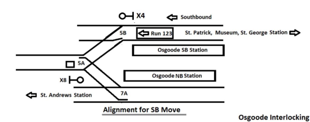
The diagram below (excerpted from the external report) shows the track layout for a train moving into the pocket. Switches 5B and 5A are aligned for movement between the southbound platform and the pocket. There is a sign at the south end of the pocket track indicating where trains should stop, but it is possible to be clear of the 5A switches without reaching this point. However, if the train stops north of that sign, signal X8 could be beside the north end of the train rather than in front of it.
Once run 123 pulled into the pocket, the 5A/5B switches realigned to their normal position for through service southbound. However, this creates a problem on the northbound side as illustrated below. The 5A switch is set for a move out of the pocket to the northbound track, but the 7A switch is aligned for through northbound moves from St. Andrew Station.
This is an inevitable result of a three-into-two track arrangement because under normal operations, both 5B and 7A will be set to the straight for regular operations. Switch 5A will direct an outbound train from the pocket onto one of the mainline tracks unless that move is blocked by some other means through the signal system.
In the pre-ATC system, the train would have been stopped by a “trip arm” at signal X8 that would have tripped emergency brakes. (In the Russell Hill crash in 1995, a trip arm failure contributed to the disaster.) In the ATC system, protection depends on the train being in ATC mode, or if in manual, the movement being carefully managed to avoid conflicts.
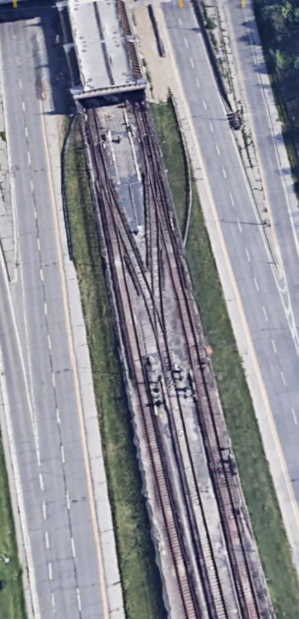
One method to protect this track configuration is used at a few exits from pocket tracks, but not all. The south end of the pocket between Lawrence West and Glencairn Stations illustrates this. There are two separate crossovers and switches leading from the pocket track, one each to the northbound and southbound main lines. Each set of switches operates as a pair. During normal mainline operations, both of these would be set leading into a dead-end track in case a train were to move south without being stopped at a signal.
Source: Google Earth
At the north end of this pocket track, there is no comparable setup, and the track arrangement is the same as at Osgoode.
Source: Google Earth
Implementing a dead end track such as at the south end of Lawrence pocket track is difficult to retrofit because there is usually something in the way. This sort of thing must be designed into lines when they are built.
Much of the discussion of this report was in camera and that took roughly an hour and 40 minutes. When the Board returned to public session, it passed two motions. The first was to have a public presentation of the investigation’s findings and the corrective actions taken over the past year at the July 7, 2021 Board meeting. The second was a clear direction that management should inform the Board about serious events at the time they occur.
Chair Jaye Robinson moved “that the TTC Board direct the Chief Executive Officer to alert the Board when an incident meeting the identified thresholds for escalation occurs and subsequently report to the Board once a comprehensive review or investigation has been completed”.
During the Covid era, there has been a gradual slippage of responsibilities from the Board to management as those at the political level have been pre-occupied with city-wide issues. The Board is there to provide oversight and direction, not simply to receive “good news” reports.
Postscript
Ben Spurr’s article on the Board’s actions is here (paywalled).
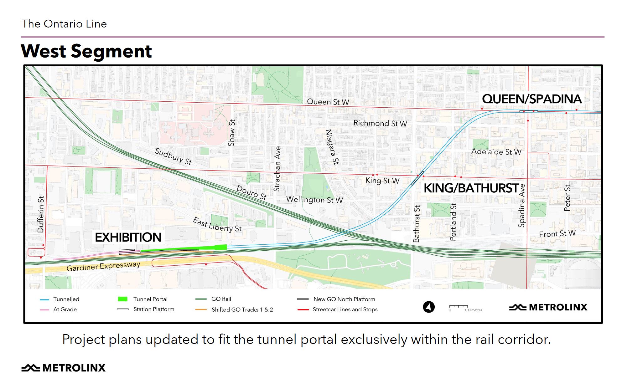
The Government of Ontario has proposed that lands they plan to acquire for station entrance buildings on the Ontario Line at Exhibition, King/Bathurst and Queen/Spadina stations will be redeveloped to increase transit demand at these locastions.
For a description of the stations sites, please see my previous article Ontario Line West Segment Update. The site plans are included here to put the proposed developments in context.
In the station building renderings, the eagle-eyed readers will note the variation (including the complete absence in some cases) of the “standard” Metrolinx “T” symbol. On the Crosstown line, it has been rendered at a size where it almost disappears, whereas here, in some drawings, it is on a similar scale to the “T” found at the MBTA stations in Boston.
All of the designs shown here indicate the general form (albeit not the height) of what Ontario would like to see, and everything is subject to change.
In the table of station usage counts, I cited the values as “all day” numbers in the original version of this article because Metrolinx own summary article showed the total value as “daily” not as “peak hourly” . I asked Metrolinx about this discrepancy, and they have not yet responded. However, they have changed the article in which “daily” was used to now say “busiest hour”. I have updated this section accordingly. Other questions to Metrolinx have not yet been answered. (Screen captures are included later in the article.)
Meetings for other segments are scheduled on:
June 17: Central downtown
June 24: Corktown, East Harbour, Riverside, Gerrard
June 30: North to Eglinton from Danforth
The introductory article for the meeting is on the Metrolinx blog and the engagement page includes links to the four meetings and resources for them.
All drawings in this article are taken from the Presentation Deck for June 10. Street view photos are from Google Maps.
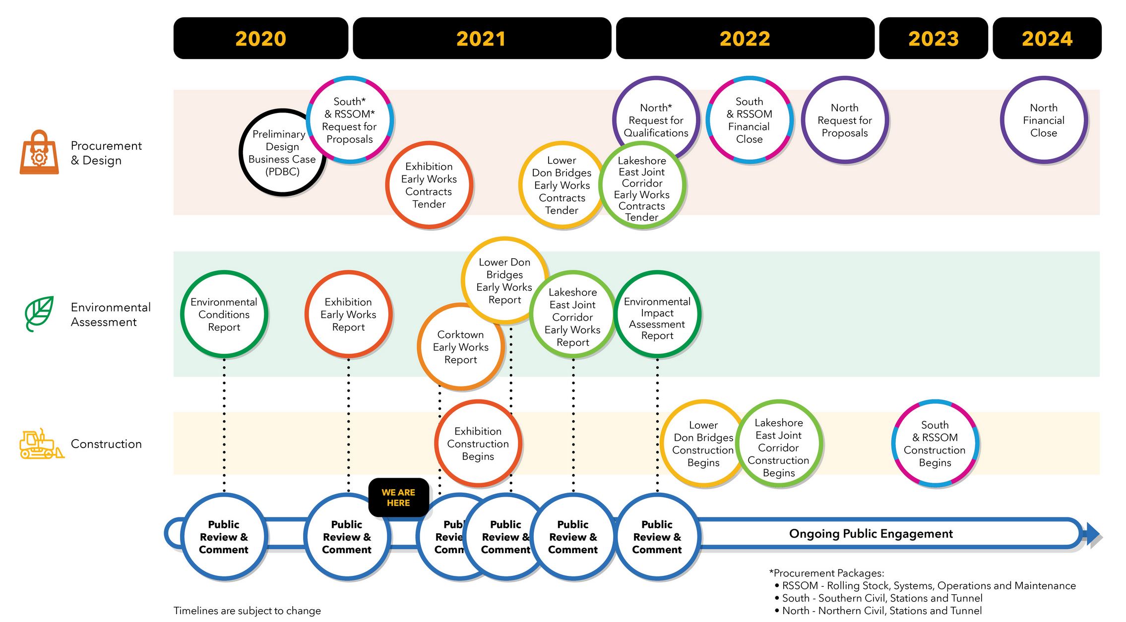
Project Schedule
A common question during the session was “when will this affect me”. The entire project is complex and will affect areas in different ways as it moves through its stages. The published schedule concentrates on pre-construction activities. In the chart below, related activities share the same colour so that, for example, the Lower Don Bridges are all yellow.
Early works that can occur before major construction include:
Exhibition Station reconfiguration and expansion (construction to begin imminently)
Lower Don Bridges (construction begins in early 2022)
Corktown Station (no start date shown in the plan)
There are four big contracts that will affect neighbourhoods along the route.
The Lakeshore East joint GO and Ontario Line corridor between the Don River and Gerrard is an “Early Work” scheduled to begin construction in the second half of 2022. This segment is controversial because of potential effects on affected neighbourhoods, and Metrolinx’ aggressive efforts to counter “myths” and “misinformation” about their project. See Metrolinx v Riverside: Where Does the Truth Lie?
In mid-2022 contracts for the south segment structures and for “RSSOM” (Rolling Stock, Systems, Operations and Maintenance) will be awarded with construction to begin in 2023.
The north segment structures contract will go to its RFQ stage in early 2022, with RFPs to selected proponents late that year. Contract award will occur in 2024 and construction would begin some time afterward.
For the south segment, the tunnels will be deep underground, typically about 30m down. They will be bored through rock starting from the west end of the line. Spoil removal and materials delivery will occur at the Exhibition with the tunnel portal west of Strachan Avenue and truck access to the Gardiner Expressway at Dufferin Street.
Stations will be built using a “keyhole” method by digging down from future entrance building locations and then mining outward to create station caverns for the concourses and platforms. This is similar to the approach used for a few stations on the Crosstown project to avoid excavating within streets. That is particularly important for locations where there are streetcar lines and many underground utilities.
The first stage of construction will be to tunnel, with station construction to follow once the tunnel is in place. Metrolinx has not published a detailed schedule, but station work would begin in 2024 in the south segment as tunnel work progresses from Exhibition east to the Don River. Metrolinx expects station sites to be under construction for about three years.
The major RSSOM construction in the early years of the project will be the Maintenance and Storage Facility north of Thorncliffe Park. After the tunnels and aboveground structures are complete, the RSSOM contractor will outfit tracks and systems, but this activity would largely be within the completed tunnels and guideways.
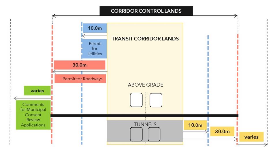
Doug Ford wants his pet transit projects built now and will sweep away any opposition. His agency, Metrolinx, is more than happy to oblige if only to make itself useful.
There was a time when the Tories hated Metrolinx as a den of Liberal iniquity, but Phil Verster and the gang made themselves useful to their new masters with new plans. Ford returned the favour with legislation giving Metrolinx sweeping powers in the Building Transit Faster Act. In particular, Metrolinx has review powers over any proposed activity near a “transit corridor” (anything from building a new condo to extending a patio deck) lest this work interfere with their plans. They also have right of entry, among other things, to perform their works.
Operative language in the Act is extremely broad about “transit corridors”:
Designating transit corridor land
62 (1) The Lieutenant Governor in Council may, by order in council, designate land as transit corridor land if, in the opinion of the Lieutenant Governor in Council, it is or may be required for a priority transit project. 2020, c. 12, s. 62 (1). Different designations for different purposes
(2) The Lieutenant Governor in Council may designate the land for some of the purposes of this Act and not others, and may later further designate the land for other purposes of this Act. 2020, c. 12, s. 62 (2) Notice and registration
(3) Upon land being designated as transit corridor land, the Minister shall,
(a) make reasonable efforts to notify the owners and occupants of land that is at least partly either on transit corridor land or within 30 meters of transit corridor land of,
(i) the designation, and
(ii) this Act; and
(b) either,
(i) register a notice of designation under the Land Titles Act or Registry Act in respect of land described in clause (a), or
(ii) carry out the prescribed public notice process. 2020, c. 12, s. 62 (3); 2020, c. 35, Sched. 1, s. 4.
Building Transit Faster Act, S. 62,
Note that there is no requirement that land actually be anywhere near a transit project, merely that it “may be required for a priority transit project”.
“Resistance is futile” should be the Act’s subtitle.
In various community meetings, the assumption has been that the “corridor” corresponds to the bounds of Metrolinx’ property, but that is not the case. A much wider swath has been defined in several corridors reaching well beyond the wildest imaginations of what might be affected lands. Needless to say this has not endeared Metrolinx to affected parties for “transparency”.
This applies to the “priority” corridors: Scarborough Subway Extension, Richmond Hill Extension, Eglinton West Extension and, of course, the Ontario Line.
In addition, there are constraints around GO Transit corridors, as well as separate Developer’s Guides for LRT projects in Toronto and on Hurontario. Note that these predate the election of the Ford government, and rather quaintly refer to the Eglinton West and Sheppard East LRT corridors. Although it is mentioned in the text, the Eglinton West Airport Extension is not shown on the map.
There is an interactive map page on which one can explore the bounds of areas where Metrolinx asserts various rights of review, control and entry. It is tedious, and one must wait for all of the map layers to load to get a complete picture. But fear not, gentle reader, I have done the work of wandering through the GTHA on this map and taking screenshots to show each line. I have attempted to maintain a consistent scale for the snapshots of the maps. All of them are clickable and will open a larger version in a new browser tab.
Readers should note that the areas of influence/control for Metrolinx corridors discussed here are separate from the effects of MTSAs (Major Transit Station Areas) on development around rapid transit and GO stations, a totally separate topic.
I will start with the Ontario Line because it is the most contentious, but Metrolinx territorial ambitions do not stop there.
In an unusual move for a public agency, Metrolinx published a blog post seeking to set the record straight on various issues about the combined Ontario/GO line corridor through the Riverside/Leslieville area.
The article begins from the premise that there is misinformation about the project:
There’s a lot of anticipation about how the Ontario Line will make it faster and easier to move around the city, but there’s also a lot of speculation and inaccurate information floating around – particularly when it comes to the vibrant communities of Riverside and Leslieville. All of this conflicting information can be confusing, so let’s take some time to sort the myths from the facts.
Sorting myths from facts can be challenging with Metrolinx because they are notoriously reluctant to share information. When they do hold public sessions, it is common to find staff do not fully understand their own project, or worse refuse to talk about contentious parts of it. They seek cheerleading, not consultation.
Metrolinx quite openly implies that community groups are putting out false information:
If you hear something about the Ontario Line that doesn’t sound right, you can find a source of truth about the project at Metrolinx.com/OntarioLine.
…
“I want people to know they can come to us at any time to get the facts about the project and what it means for them,” says Malcolm MacKay, Program Sponsor for the Ontario Line.
“There is definitely some speculation and inaccurate information going around, and we want people to base their opinions and feedback on the most up-to-date plans.”
What does Metrolinx claim in their article, and how does this stack up with the real world?
Debates on the effect of Metrolinx service expansions often turn on noise and vibration effects, the degree to which any new or modified service will change the communities through which lines pass. Nowhere is this more striking than in Toronto’s Riverside district where an existing three-track GO corridor will be widened with a fourth GO track plus two Ontario Line tracks.
Reviews of the effects along the GO and OL corridor are hundreds of pages long for those who have the stamina to dig through appendices in so-called environmental reviews, but the material is inconsistently presented. Three separate projects affect this corridor, but no study considers the combination of three services.
This is a major oversight, and it hobbles any public consultation. Metrolinx appears either unable to answer valid questions about the effects of new services, or worse unwilling to reveal information that they should already have. Past experience makes communities distrust what Metrolinx says especially if “consultation” sounds more like cheerleading for decisions made long ago by sage transit wizards.
Updated 4:15 pm: Due to an error in a spreadsheet, the summary counts are off a bit because existing service was included in future totals. This has been fixed.