
Metrolinx held one of their online consultations on April 22. This time the subject of the Ontario Line between the Don River and Gerrard Street. Normally, I would not review meetings like this in detail. However, I had proposed an alternative alignment and have worked with community groups on this. A reply to statements made by Metrolinx at the meeting is, sadly, essential because of the misdirection and misinformation in their presentation.
The presentation deck for the meeting is available online as is the video of the session on the event page. I will not rehash all of this material and leave these to interested readers.
It was quite clear that Metrolinx thought that they had a presentation to answer the community’s questions, and they launched into it in their usual confident style. However, as the session progressed, and especially during the question-and-answer period (which require a meeting extension to fit everything in), things started to come unglued.
A common tactic would be for Metrolinx to reply to a question with either a partial response, or with a discussion of an issue that had not been asked. I could be generous and assume that they just didn’t hear the question properly, but this happens too often to be pure chance (or mere incompetence). This suggests a deliberate misrepresentation of questions by providing an answer to something that was not asked.
Many questions were submitted in advance on the event page, and these were bundled by the moderator for Metrolinx’ answers. I have consolidated responses from different parts of the session to group related comments together.
Readers of previous articles will be pleased to see that Metrolinx has produced a map with North at the top where it belongs.
The original hoopla about this portion of the Ontario Line included the alleged virtues of the “straddle” design with OL tracks bracketing the GO tracks to allow cross-platform transfers at East Harbour. Metrolinx has now discovered that this brought extra cost and design disadvantages, and they now tout the side-by-side alignment’s benefits. Metrolinx plans are immutable, at least until they embrace a better idea.

What is the Cost of Going Underground via Carlaw? What would be the Effect on Project Duration?
Several questions asked about building the Ontario Line through Riverside underground including the option via Carlaw put forward by the community groups based on my scheme.
MacKay answered that having lines with a variety of alignments – underground, at grade and elevated – is not unusual. He cited the Eglinton Crosstown Line 5 which has segments of each type, although the elevated portion is a short valley crossing. Metrolinx looked at different types of construction and how these would affect the community. He observed that Metrolinx owns the rail corridor and it is wide enough to contain 4 GO and 2 OL tracks.
The line will provide connections to other parts of the rapid transit network and will bring relief to congested areas, MacKay argued while failing to acknowledge that these benefits are common to any alignment. There are benefits and disbenefits, and taxpayer dollars much be spent well.
Metrolinx considered various options:
- Underground under the Don River
- Underground north of Eastern Avenue (after leaving East Harbour Station)
- At grade
According to MacKay the cost premium for underground options ranges from $0.8 to $1.0 billion, and the construction period would be 1 to 1.5 years longer. The at grade option allows combination of work with GO Transit on a corridor Metrolinx already owns and frees up money to provide more transit to the entire city, he said.
It was clear that this response was based on previously studied options, and MacKay did not address the alternative proposal even though he was asked. That alternative avoids tunneling under the Don River and shifts the location of the North Tunnels launch site from Gerrard Street south to lands near East Harbour Station. It also avoids the physical constraints that would apply to a drop from the rail corridor at Eastern to underground at Queen.
Moreover, the desire to save money to build more transit runs counter to the flagrant spending on both the Scarborough Subway and the Eglinton West underground extension.
What are the Bounds of the Corridor? When Will Metrolinx Publish a List of Affected Properties?
Questions in this section included what the effect would be on nearby properties and buildings, as well as what safety margins were required around the corridor. Metrolinx has standards for new builds that require substantially more space between mainline railway tracks and nearby structures, and that there are crash standards for operation of different vehicle types in a shared corridor.
MacKay did not address the issues of minimum clearances or acceptable safety margins between modes.
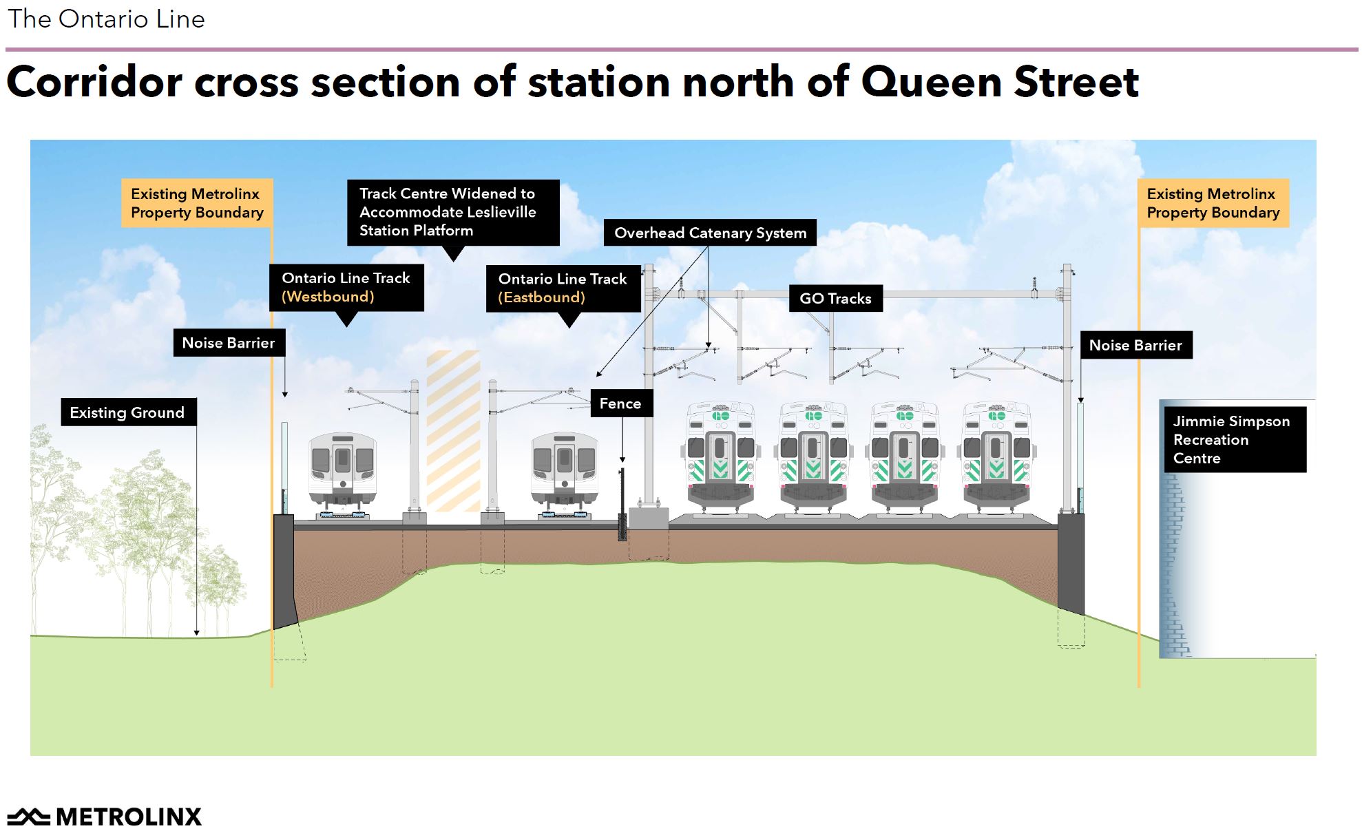
According to Metrolinx, the six track corridor will fit within the Metrolinx right-of-way as shown on the map below. This raises several issues:
- The property line is immediately west of the Jimmie Simpson Recreation Centre. Is this a safe separation?
- Some of the land within Metrolinx property is now open space that has operated for decades as park land. Metrolinx does not show “before” and “after” limits of their infrastructure to indicate how much open space and vegetation will disappear.
- The claim that the tracks will fit within Metrolinx lands is contradicted by the discussion of property acquisition and expropriation.

The corridor’s cross-section at Queen Street shows how close tracks and structures will be to the Recreation Centre and the amount of space that will be taken by the Ontario Line which is west of the space now occupied by the three existing GO tracks. In spite of its size, this design requires less space than the original OL proposal.
- By separating the 4-track GO corridor and its electrification infrastructure from the 2-track OL corridor, construction is simplified and the two power distribution systems are separated.
- The “Leslieville” Station requires only one shared platform and associated access paths compared to separate platforms with the original “straddle” option where the northbound OL track would have been on the east side of the GO corridor.
- The combined corridor is bounded by retaining walls rather than embankments thereby reducing its overall width.
Where provision for a station platform is not required, the corridor can be narrower as shown below. This drawing shows the option on bounding the corridor with a vertical retaining wall, or using an embankment.

On one hand, Metrolinx talks about the expanded corridor lying entirely within their property, but on the other talks about acquiring property by negotiation of expropriation. Other than temporary easements during construction, why do they need to acquire property if they already own the land the six tracks and stations will occupy?
• If we confirm your property is needed, you will receive written notification from us. Metrolinx strives to communicate with property owners early and often so that there is ample time to work through solutions.
Presentation deck, p. 14
• Our preferred approach is direct, one-on-one negotiations with owners, with the goal of reaching amicable agreements.
• Expropriation is a backstop tool. Even when expropriation is initiated, Metrolinx continues to negotiate with owners in the hopes of reaching agreements.
• Whether we have to acquire a portion of a property or the entire property, the property owner will be compensated at fair market value, and our commitment is to ensure that owners and tenants do not experience a financial loss.
Metrolinx talked about its design priorities and the benefits of noise and retaining walls, but entirely ducked questions about property requirements. A central problem with their presentation is that generic design drawings do not show the specific effects of the expanded corridor step by step along its length.
Neighbourhood Intrusion
In Metrolinx current design, the North Tunnels project starts at Gerrard Station and drills north to the Don Valley just west of the Leaside Bridge. This places the Tunnel Boring Machine (TBM) launch site at Gerrard Station.
MacKay noted that with the shift to the north/west side of the rail corridor, the portal at Gerrard would be less disruptive than in the original design and that the launch site would be entirely within the property owned by Choice REIT. He did not address concerns about the effect of construction on the nearby Pape Avenue School.
Discussing underground alternatives, Metrolinx cites the need for the TBM launch site to lie between Eastern and Queen south of Leslieville Station with associated street closures and building takings. However, this is not the alignment proposed by the community in which the TBM site would be somewhere east of East Harbour Station and parallel to Eastern Avenue, and the bore would be continuous from there to the Don Valley at Leaside.
Noise & Vibration / Quantity of Service
A fundamental flaw in studies to date of Ontario Line and GO corridors is that each study ignores the existence of the other mode. OL studies look at noise and vibration from OL trains, while GO studies consider only GO trains. There is no published study of the combined noise level for operation of both modes in the same corridor.
MacKay cited a trains/hour value of 113 in the AM peak 30 years out. Assuming that the Ontario Line would be operating at 90 second headways (40 trains/hour each way), this leaves 33 trains/hour for GO and other mainline services, or about one every 7 minutes on each of four tracks, a value in line with GO’s plans.
The mode of GO trains is not yet certain. Although Metrolinx touts the quieter operation of electric trains, there will be far more of them. Moreover, current plans call for many trains on this corridor to operate with diesels because they will run beyond the end of electrified territory in Oshawa. (Metrolinx does not own the proposed corridor between Oshawa and Bowmanville.) It is equally possible that 30 years out, another technology, some form of hybrid electric train with off-wire capabilities, will be available, but meanwhile the service plans for the Lakeshore East corridor are not all-electric.
Metrolinx claims that sound modelling shows a benefit in reduced noise levels thanks to noise walls and improved track construction, but they do not clarify what mix of propulsion technologies and train consists they have used in the model. They have also not addressed the change from the occasional presence of loud trains to the constant presence of either OL or GO trains much more frequently than today, even if individually they are quieter.
As an aside it should be noted that the “improved” track construction for the Ontario Line (welded rail and rubber mechanical isolation from the track support structure) has been standard for rapid transit construction in Toronto for decades. As for the GO trackage, eliminating the “clicketty-clack” of rail joints and the use of welded rail is an integral part of the electrification project (the rails act as the ground return for the power).
Metrolinx said that they are “running the numbers”. This implies a recent activity whose results might not yet be complete, and undercuts the implication that all necessary study has already happened. At the end of the day, they expect to improve noise levels at many locations along the corridor, but have not yet specified where, to what degree, and the baseline for their comparison.
What Transit Oriented Development is Proposed?
Recent news about developments near Corktown and East Harbour Stations triggered a question about what “Transit Oriented Development” (“TOD”) is proposed at stations in Riverside, specifically at Queen and De Grassi.
Richard Tucker from Metrolinx confirmed that there are no plans for TOD at Queen Street. Whether this is trustworthy in the current political environment is anyone’s guess. The Province and Metrolinx hope to recoup station costs from nearby landowners as part of development deals, but this is unlikely to pay for any underground stations. Metrolinx has touted development that will pay for a new Mimico GO station, but this is a surface station on a rail corridor.
East Harbour is a strange hybrid where the GO station, under the rubric of “SmartTrack” will be paid for by the City of Toronto while the Ontario Line station will be paid for, Metrolinx hopes, by developers of nearby property.
Metrolinx claims that any affordable housing within new developments will be part of the TOD requirements within Infrastructure Ontario’s development of properties, but this does not say anything for lands near stations that are now privately owned as at East Harbour and at Gerrard.
What About the Community/City Endorsed Proposal?
A complaint from some participants was that Metrolinx had not addressed questions put to them, and in particular the alternative put forward by the community. Toronto Council recently voted to ask Metrolinx to study this proposal. Thanks to the draconian laws related to the provincial takeover of major transit projects, the City is barred from conducting such a study itself.
What is the cost to run underground as proposed from east of East Harbour Station to Gerrard via Carlaw? Is this possible and viable. Is this simply a case that it is easier for Metrolinx to put the Ontario Line in the rail corridor?
MacKay replied that “we have heard the community”. He described the proposal as a hybrid Relief Line South solution, which of course is precisely what it was intended to be, and noted that he worked on the RL when he was at the TTC. Going up Carlaw is not easy because the tunnel must pass under the Mid-Toronto Interceptor Sewer. He went on to say that the Relief Line and Ontario Line alignments were considered in the Initial Business Case work, and Metrolinx landed on the Ontario Line as it could run to Eglinton and provide more relief for Line 1 at Bloor-Yonge. He neglected to mention that delays in design work on the Relief Line north of Danforth were caused by Metrolinx foot-dragging and the 2018 election.
To paraphrase MacKay: We do hear you and your expectations. Using the existing dedicated rail corridor that has been there for over 150 years allows us to build more transit. Using a different technology with shorter stations allows city building to maximize the outcome from the investment. This may not be the outcome you want, but it is the project we have and it’s our job to engage the community and elected officials and deliver more benefits to everyone involved.
That’s as close as MacKay got in this meeting to remarks he has made elsewhere that Metrolinx can effectively do what it wants. By implication any debate starts at a huge disadvantage from their need to produce results quickly for their political masters and simply to prove that their design is the right one.
Challenged to produce plans and a budget for every part of their proposal, MacKay replied that Metrolinx does have cost estimates and will be able to share this information showing the delta required for the suggested alternative. Metrolinx “loves the challenge” and wants to demonstrate to the community that design concerns are “systematically approached and mitigated”.
How Deep Would Stations Be?
Whenever Metrolinx talks about underground options, they trot out the problem of deep stations and complicated connections with surface routes as a standard critique. A 70 metre station depth is cited fairly regularly, and was quoted by Malcolm MacKay. He cited his experience working on the Relief Line South project before he moved from TTC to Metrolinx.
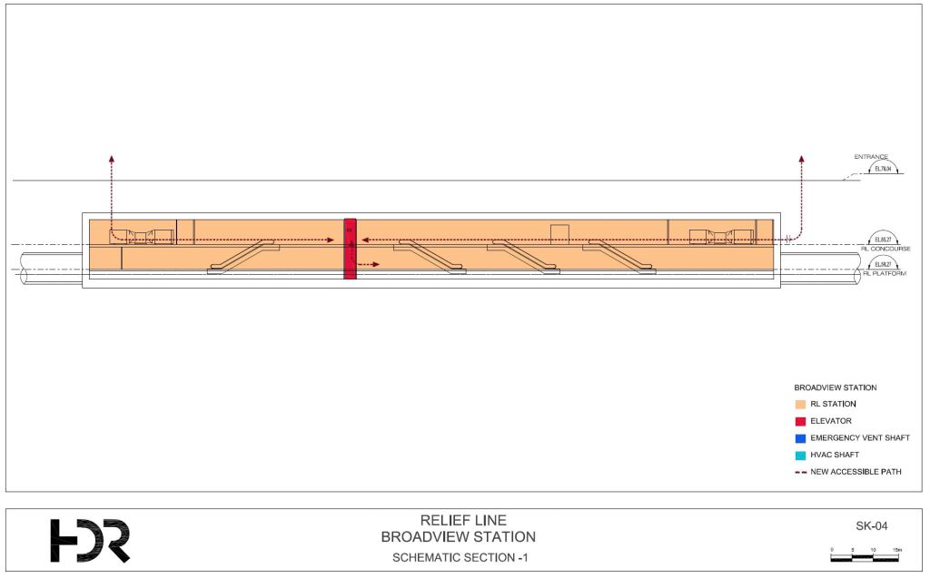
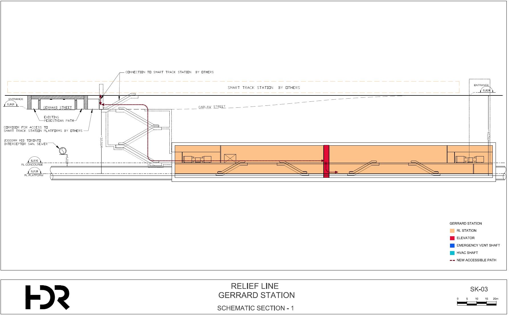
MacKay should look at his own project’s drawings. Here are Broadview, Carlaw and Gerrard Stations from the Relief Line designs in 2018. These show the horizontal and vertical alignments (first drawing of each pair) and the station profiles (second of each pair). [Click on the drawings to expand them in a separate tab.]
The three stations range from about 20m to 40.5m underground measured from the surface to platform level as shown on the drawings. Somewhere along the line, has Metrolinx confused feet and metres, or are they comparing a much revised and deeper version of the Relief Line to their Ontario Line as a straw man?
MacKay stated that in earlier consultations undergrounding was a consistent refrain, but that this might not be the panacea people perceive it to be. He went on to discuss construction problems and disruption required to build an underground station at Queen and De Grassi even though this is not on the alignment advanced by the community groups. He completely ignored the alternative alignment and, for that matter, whether that station is even required considering that no redevelopment is planned there.
Broadview/Eastern
Surface level at Broadview/Eastern station is at about 78m while the platform is just above 58m, a difference of 20m.
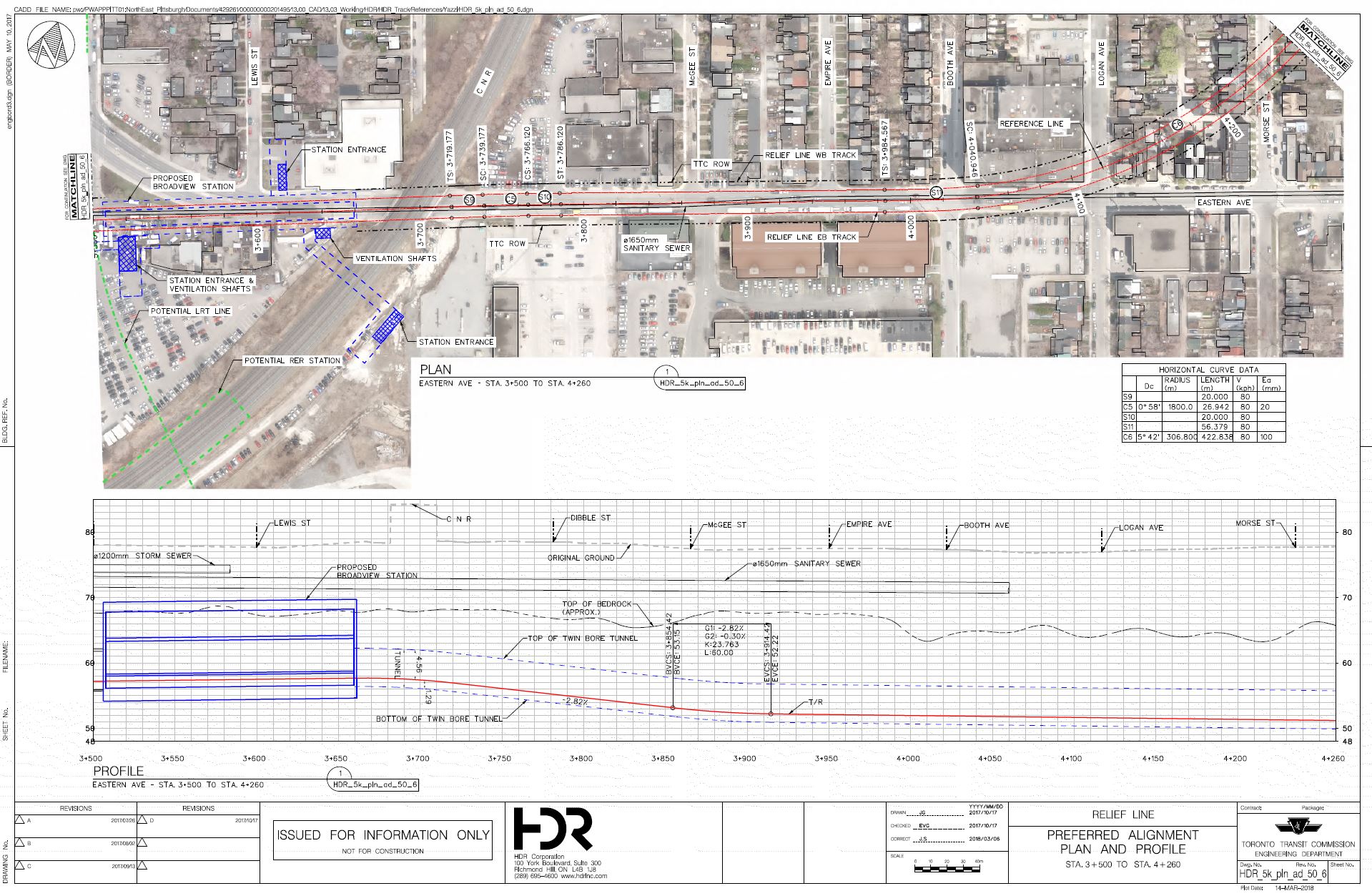
Queen/Carlaw
The station at Carlaw is moderately deep because the tunnel runs beneath a major sewer on Carlaw. Street level is at 79m and platform level is at 51m, a difference of 28m. (Note that the legend on the cross-section says “Sumach Station” but the main title of the drawing says “Carlaw Station” which is the correct name.)


Gerrard/Carlaw/Pape
The station at Gerrard is the deepest of the three because the tunnel goes below the Mid-Toronto Interceptor Sewer at Gerrard Street. Street level is at 92.5m while platform level is at about 52m, a difference of 40.5m. In previous consultations this depth had been an issue for Metrolinx because of the long transfer with a proposed SmartTrack station. However, this is no longer a stop for trains on the rail corridor, only with surface TTC routes.


Our community was appalled by the presentation and the way they dodged and defected our questions about underground routes, and costs – with reasons not to put the line underground. They continue to try and convince a community which had a viable shovel-ready underground plan in the Relief Line, that it’s impossible to put a subway in our community. That’s how absurd they are and you’ve done an excellent job capturing their nonsense in your analysis.
LikeLike
Amused to read this:
This does not appear to be the case with their expropriation of the First Parliament site where they seem hell bent on owning the site by August 1. The City report on this states
LikeLike
In the community’s underground proposal, where would the primary and secondary stations be located for Queen/Carlaw and Gerrard/Carlaw stations. Despite expropriations being a concern, it seems that something needs to be demolished in order to build the entrances.
Steve: The stations at Carlaw/Queen and Carlaw/Gerrard/Pape would use the Relief Line designs, modified to allow for the shorter OL trains. In the RL plans:
Carlaw/Queen: Existing buildings on the northeast and northwest corners of the intersection would be demolished.
Gerrard: The principal entrance is on the northeast corner of Carlaw and Gerrard, and the station box lies on a diagonal from roughly that point under the parking lot. It will fit within this area which is earmarked for future development. An auxiliary entrance opens onto the west side of Pape just north of the rail corridor.
Both of these are approved designs in the 2018 EPR.
LikeLike
I get that it’s easy to be annoyed with Metrolinx for not communicating exact property requirements in a community meeting like this. It would be very interesting to know. But from a legal perspective, it’s what they have to do. The community doesn’t have a right to know before the landowner, and we don’t know where Metrolinx is at negotiations-wise with every potential party.
With the possible exception of 242 First Ave and maybe 2 Paisley, there are no buildings close enough to the tracks to warrant any kind of demolition. Right? All they might need is part of a backyard or parking lot. And even then, there are really only a few properties that could possibly be affected by this, like 14 Tiverton. Nobody on Saulter, DeGrassi or Wardell is at any risk here.
Steve: That could very well be so, but it would be so much simpler if they just said that. As it is, on one hand they claim that the line will fit within their existing property line, although many are uncertain exactly where this is and, as a matter of public record, it would be no legal problem to provide this information. On the other hand, they spent an entire slide in the presentation talking about property acquisition. This may well apply to other parts of the line, but you can see how there is an apparent contradiction.
A related issue is the unanswered question about minimum distances to adjacent structures. The tracks may fit in the existing corridor, but the resulting configuration might put trains and buildings dangerously close to each other triggering thoughts of removing the building(s) affected. Metrolinx refuses to address this issue even in the abstract of discussing what the standards are. It is particularly hilarious that their meetings begin with a soporific “safety moment” while an obvious safety issue in their design goes unaddressed. What are they trying to hide?
LikeLike
Not 100% sure what you’re going for here – but bi-mode electric & diesel trains are now pretty common around the world. Just clarifying 🙂
Steve: There is a big weight penalty for a bi-mode locomotive these days, and other technologies such as batteries and hydrogen have not yet been scaled up to large trains such as Metrolinx runs. Obviously it won’t take 30 years, but Metrolinx seems to be headed down the path of preserving pure diesel operations beyond its own territory for the foreseeable future. This will leave us with a fleet based on loco-hauled coaches for some time. Eventually they will start to wear out, and some future government will decide what to do.
LikeLike
Always thought that the “70m deep” line was hogwash – that would be as deep as the new Édouard-Montpetit REM station in Montreal, deep below Mont-Royal – and served only by high speed elevators!
Steve’s kind and gentle voice: I will generously assume that somebody does not know how to read drawings rather than that they were deliberately trying to mislead people.
However, that 70m depth has been a Metrolinx trope for some time, parroted unquestioningly as a quick example of how the Relief Line was such a bad design by Toronto and the TTC.
LikeLike
One woman at the online meeting lamented the loss of the shopping centre (to be used as a TBM launch site) at the north-east corner of Carlaw and Gerrard. However, it seems it would also be lost using the community’s proposal as the site would be needed to dig an underground station.
The north-east corner of Queen and Carlaw appears to have a recently renovated heritage building. Perhaps the ex-bank building on the south-west corner would be a better choice by preserving its façade like the ex-bank building at Mt. Pleasant station.
Steve: First off, it is important to recognize that the “community’s proposal” deals with the south end of the route around East Harbour. From Carlaw northward, the proposal is simply to use the already approved Relief Line design adjusted for the shorter trains. I cannot say this strongly enough: the community simply wants the already agreed-to design used as much as possible given the efforts and compromises that went into it. Metrolinx is happy to spend billions placating Scarborough and Etobicoke residents and politicians who fear monger about surface LRT, but don’t want to address Riverside where there is already an approved design.
As to specifics of station design, at Queen the original plan shows the west side entrance on Carlaw at the north end of the Shoppers Drug Mart and the east side entrance at the corner where the building has just been restored. Given that any Shoppers site, almost by definition, is a potential redevelopment location, the west side entrance could move to the corner in a new building, and the east side entrance could go further north behind the heritage building.
At Gerrard, there was always going to be a big hole with either design for a station or for a TBM launch site. Choice REIT owns the site and plans to redevelop it. The future of the shopping there as we now know it depends on that development, not on the Ontario Line.
LikeLike
You have a statement:
“Going up Carlaw is NOW easy because the tunnel must pass under the Mid-Toronto Interceptor Sewer.”
I believe that should be NOT.
Steve: Thanks for catching that! I have fixed the text.
Your Station Depth segment shows clearly what I was saying all along – going under the Don does not lead to deep stations. You have Eastern at 20m depth. It is going under Carlaw that leads to the great depths. 28m at Queen and 41m at Gerrard – I would also add 3.5m or so to each if we are talking construction and including foundation excavation. The key to any change proposal would be to go over this sewer. You can’t go over, run parallel, and have stations, so that would mean returning to the original (2016) alignment – going 90° across (and above) it and then turning up Pape. Since there isn’t the headroom to tunnel, this portion (likely all the way from Eastern/Broadview to Pape/Millwood) would be build using cut-and-cover – which would lead to faster (and cheaper) construction. The portion backwards from East Harbour under the Don would be tunneled (TBM).
Residents had the opportunity to put the entire line underground. Some disruption measured in months was the cost – faster station construction and fully underground for the next 100 years was the benefit. However, failure to realize the constraints of the problem and proposing a mutually beneficial solution led to their proposal being dismissed.
Steve: I used the difference between platform level and street level as the measure of depth because Metrolinx keeps harping on the length of time for riders to travel vertically to access the station.
As for a cut-and-cover option, the disruption would be much more than “months”. The residents’ proposal was hardly “dismissed”. It became the basis for the DRL design.
The problem lay at Metrolinx who were trying to show off to their new master, Premier Ford, that they could build a “better” subway than Toronto had designed. Their attitude was clear in their early comments about the TTC and its “out of date” technology for which they eventually apologized, sort of. They have a long history, and not just on this project, of being insensitive to and dismissive of neighbourhood concerns.
LikeLike
The decision to go under Carlaw Avenue in RL v2.0 after a few dozen homeowners objected to v1.0 really has led to a lot of grief hasn’t it? I’ve never seen any detailed estimates and comparisons produced to show cost deltas and the like, only a few drawings showing comparative station depths. Maybe I missed it.
Once Fletcher picked up the banner it was inevitable that v1.0 would be buried. Pardon the pun. Now the revolving transit plan doors spin again and in v3.0 no one gets a tunnel.
Steve: No one gets a tunnel in Riverside. If you live anywhere else, Metrolinx will happily build you tunnels galore.
LikeLike
I firmly believe Metrolinx uses its power to bully its way to whatever it wants and unfortunately, it gets it wrong every time. The citizens of Riverside have my sympathy but in compromise, some concessions will be hard to take. It seems to me that the compromise the citizens of Riverside have to make is that to keep the Ontario Line underground, the route will be up Pape. The compromise Metrolinx has to make is that they will make every effort, with large indemnity provisions, to make the tunnel under Pape, the least disruptive possible from a construction and operational point of view, and that with this concession they will modify designs not to tunnel as deep as the TTC designs.
Walter’s posts on this matter give the engineering reasons.
In the larger picture, the Ontario Line will not be a “relief line” because Yonge is overcrowded because of the developments of apartment complexes in North York, Eglinton and St. Clair. The eastern parts of the Ontario Line are in under-served regions but BRT’s and road design can address their needs, not rapid transit.
In the bigger picture, the crisis Toronto has is the overcrowding of the Yonge subway and the crowded Bloor/Danforth. Metrolinx should be spending its resources working on these problems, not the Ontario Line.
The bigger picture is the current provincial government is pushing the wrong transit projects, not only the Ontario line, but the Yonge extension adds to the overcrowding and the Scarborough Subway Extension at $6 billion for 103,000 daily rides is a waste and in a way, contributes to the Yonge problem. In addition the government eased development laws to increase apartment development along Yonge. They are blind to the fact that the Yonge subway has reached capacity.
The even bigger picture is that the Liberals are just as bad at understanding public transit and the NDP have not proposed any alternatives.
Steve: I would even say that the NDP has a bad habit of thinking subways are good because they represent lots of construction jobs.
Until we stop spending a lot of money on a few megaprojects and start planning to give benefits over a wider range, it does not matter which party is drawing the map this week.
LikeLike
It seems the community is missing the opportunity to get the Feds involved so that the OL line is buried to make way for the HFR traffic. Perhaps writing up an appeal on some basis within the Fed’s Railway Safety Act will trigger a cumulative assessment of what’s the overall plan.
Steve: There is already a request for a federal EA.
LikeLike
Does anyone know what these cars will look like? The have pans and overhead. Are they going for similar equipment to REM?
Steve: Metrolinx shows generic cars, but claims that the actual choice will be up to the eventual P3 operator whose identity we don’t know yet.
LikeLiked by 1 person
Go look at Streetsville station and see how the powers convert homes near the station to parking lots. There is no guarantee that expropriated land will be used well.
LikeLike
I sometimes wonder whether the real reason that Metrolinx is wedded to this design is that they can’t get the province to pay for GO train improvements, so they need to bundle together their track improvements and their new train station together with a higher priority project like the DRL to get them done. Similar with the Yonge extension to Richmond Hill, where they redesigned the project to best suit GO Transit needs even though GO is of minor importance compared to the huge ridership of the subway.
LikeLike
It’s ridiculous that Metrolinx spread FUD about the disruptions of some fictional portal south of Queen rather than along Eastern.
My ongoing concern is capacity. If the OL is to do its job as modelled in Metrolinx’ own studies, it has to carry 21,000 pphpd on opening day, and closer to 28,000 in the 2040s.
They already chose a technology that usually has narrower cars (but not always). But from the drawings, those are very short stations. Does anyone know how long the stations are?
What length of station are they protecting for (especially underground)? If longer underground stations don’t go in the contracts, I can’t see how the OL won’t end up being a boondoggle when those stations need to expand. Either that, or the OL will end up being toy train.
Steve: We have not yet seen station designs, specifically whether station boxes will be planned for longer than “day one” service somewhat like the stations on Line 4 Sheppard. The attitude appears to be that capacity will be added by running shorter headways, not longer trains. There is a related problem in that the P3 who will provide and operate the equipment is separate from the P3s that will build the tnnels and stations. This implies that the station designs will be based on a nominal train size, and the P3 providing the trains will have to work within that. Such are the joys of Metrolinx’ fragmented and secretive design process.
LikeLike