
Updated April 12, 2021 at 9:30 pm:
The map of the northern segment of the Ontario Line published by Metrolinx in their October 2020 blog article has been added for reference. Scroll down to the end of the article.
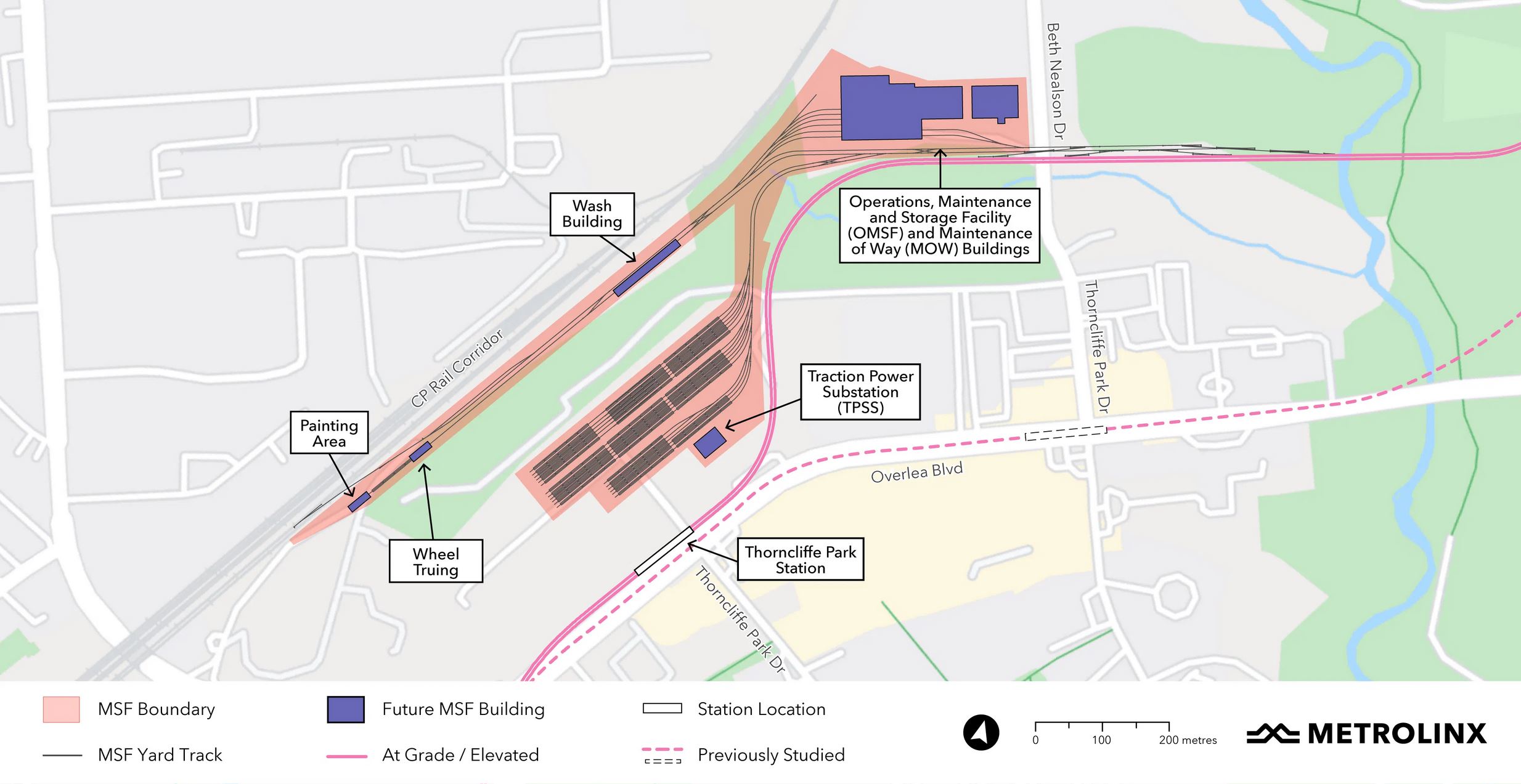
Metrolinx has unveiled a plan for the Ontario Line’s Maintenance and Storage Facility north of Thorncliffe Park. Because of the local terrain, green space and the Hydro corridor (not shown on the map below), this is split into three distinct sections:
- The main buildings are west of Beth Nealson Drive north of the Don River.
- Some servicing areas are in a long spur parallel to the CPR corridor. This will also be the location of a delivery track where vehicles will arrive from the manufacturer.
- The storage yard will be in an area now occupied by various shops and offices as well as a mosque.
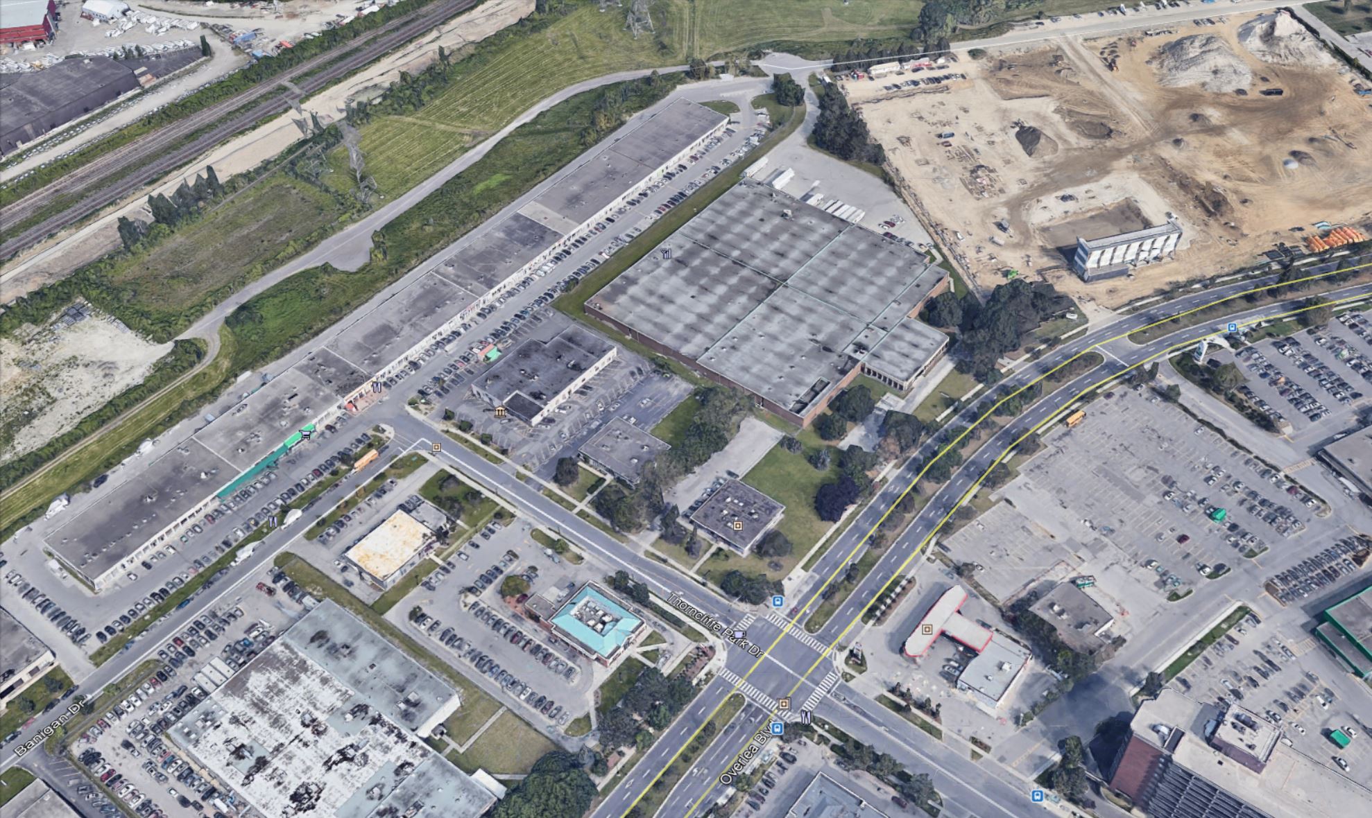
Here is a satellite view from Google Maps rotated to match the orientation of the map above.

The area to be occupied by the yard at the north end of Thorncliffe Park Drive West is shown below. This was taken before the Costco building went up on the vacant land in the upper right of the photo. The Ontario line will run north from Overlea Boulevard along the west edge of this property.
Google Street View east from Thorncliffe Park Drive at the future storage yard.
The area for the main buildings on Beth Nealson Drive is shown below as it currently exists.

According to the Metrolinx Blog article on this plan, the site was chosen from a list of nine. Metrolinx has not published the other locations that were considered.
The work we did to identify the best site for the MSF and yard will be pulled together as part of the Environmental Impact Assessment Report that will be available in 2022.
We can let you know we looked at land near the western terminus at Exhibition all the way to the east and to the northern end of the alignment. A list of nine sites were brought forward for more detailed analysis, some of which were ruled out because they weren’t big enough or they affected too many businesses and jobs.
The site in the southeast portion of the Leaside Business Park was selected because our studies showed that it keeps impacts to the local community to a minimum while meeting all of the needs for the project:
• it is already zoned for industrial use;
• it is close to the main line, making it quick and easy for trains to go in and out of service;
• it is large enough to meet future needs;
• it minimizes community impacts;
• has less individual job impacts.
Email from Metrolinx Media Relations, April 9, 2021
While the northern portion that will house the main buildings might only displace a self-storage farm, the southern portion where the yard will be located sits on top of buildings that are an integral part of the Thorncliffe Park community. What the reaction will be might be gauged at an online meeting to be held on April 15, 2021 at 6:30 pm.
Updated April 12, 2021 at 9:30 pm:
When Metrolinx announced their revised route through Thorncliffe Park in October 2020, they touted the fact that this would avoid disruption of buildings such as the Macedonian Orthodox Cathedral. The map of the revised route is below.

Note the area labelled “MSF Study Area”. This is the location, in the updated plan, for the Operation and Maintenance building. The area at the north end of Thorncliffe Park Drive West is not touched by the line and there would be no reason for anyone to raise flags about the businesses and institutions already there.
The yard which is now part of the complex is completely new, and there was no advance indication that this would be part of the design.
On a related note, one of the comments below from Simon Hirst suggests that an alternate location might be the land on the other side of the CPR corridor now occupied by a gravel and cement company. This is visible as a white patch directly above the “MSF Study Area” in the Metrolinx map above (where “north” is to the right, and “west” is up), and in the view below which is a closer view of the same area in the usual geographic orientation.

If that area were to be used, a connection tunnel would have to go under the CPR to link with the Ontario Line whose main shops and offices would be where the brown-roofed buildings labelled “Toronto Moving and Storage” are in the upper right of the photo.
Because Metrolinx has not published its list of alternative sites, we do not know whether this option was considered but rejected for some reason.
Metrolinx does not plan to publish its alternative site analysis until Fall 2022 with the Environmental Project Report, but they also intend to let the contract the includes construction of the MSF and yard at roughly the same time precluding major changes in design.

I guess it depends upon the immediate neighbourhood’s support of the Line itself, but I doubt that they could have picked a more politically and socially complex location. It won’t be a simple process.
As well, why is there an assumption that zoning will suddenly render CP a benevolent party when they have been portrayed as totally opposed to any through line that soils their right of way?
Steve: The Metrolinx proposal only touches the CP line for the purpose of a delivery spur, not for the OL itself nor for the yard and MSF.
LikeLike
Metrolinx might want to leave the mosque and the strip mall alone. They are key parts of the whole community. A better plan would cross Millwood and expropriate the Loblaws on Redway.
Not sure if this would allow enough land area to house all the trains, but by co-opting the Bala sub down into the valley, they could park additional units there too.
Steve: There are issues on the Bala Sub too. Metrolinx wants to use the area south of the bridge as GO storage, and the locals are not amused to the effect on the parkland. Full disclosure: I live right beside the area in question.
Another concern is the Hydro corridor in the area. Hydro is never thrilled with the idea sharing their corridors with high voltage transit. While the MSF is not actually right under it, the facility will be directly adjacent and almost any move from one part to another of the facility will run under the high tension power lines. Again, repurposing the Redway site might be a solution, as could an East Harbour location, though that might require more in the way of an access route.
Steve: I have a suspicion that Redway would not come cheaply. Also, unless you are prepared to cut down a lot of trees, it’s too small. You can compare the sites on Google.
Even if the MSF goes as planned, moving the Thorncliffe station stop into the parking lot of the mall, would allow better bus connections. All this would require is routing the line up the east side of the Costco property.
The proposed (preferred?) northern main line route out of the MSF is already north of the Hydro lines and it would be difficult to drop back south again once across the West Don river. How this will affect the proposed route through the south end of Flemingdon Park remains to be seen.
LikeLike
Wonder if the NIMBYs in the neighbourhood would accept the MSF if they were told the residents in the area will get first dibs on jobs at the facility?
Steve: Do you have any idea of the nature of Thorncliffe Park? NIMBY is about as far away as you can get, as is most of the housing.
LikeLiked by 1 person
The Relief Line was going to use Greenwood Yard initially.
Since we don’t know what the study was for the other sites, it’s hard to give any feedback but I do wonder if Metrolinx had considered using Greenwood Yard (obviously, redesigning it to accommodate the Ontario Line trains alongside the subway trains) and building connecting track along the west side of the railway corridor. Maybe that would be a more expensive solution in the long term but it could avoid some of the potential community relationship building issues that they are going to face.
Steve: The proposed yard at Kipling would have to be designed, built and open before Metrolinx could take Greenwood. No, even longer, because the co-existence of Greenwood and Kipling is essential for the changeover from the existing T1 fleet on line 2 and whatever replaces it. Leaving aside cost and other factors, the timing does not work. Also, this would require a junction with the OL at Gerrard Station making it more complex, and would widen the corridor needed between Carlaw and the west side of Greenwood Yard. This would complicate an already messy situation with people living along the corridor.
One thing that Metrolinx could do is come to the community and offer them something similar to the community-generated and community-led proposal for a community hub and affordable housing in front of the Finch West MSF. Now, that example isn’t a great one given that the process was quite messy and frustrating, but it might be a face-saving option. It would also show that they’re willing to not only listen but really work together with a community for mutual benefits.
Steve: A big difference at Finch West is that Metrolinx already owns the land, and the community centre is a future project, not a collection of existing buildings. They would have to buy and probably develop new land in Thorncliffe Park in order to replace existing buildings/uses before they could be demolished.
There is a fundamental problem with so many of Metrolinx’ plans that with the constant delays and redesigns, not to mention the secrecy, a lot of clocks have run out on options that might have been viable if we had more co-operation and transparency from Metrolinx and less pressure to move “now” so that Doug Ford has something to show for his failed term.
LikeLike
Without suggesting anything but positive intentions, it’s baffling that Metrolinx’s position on releasing other potential options (or even just a short-list) is “trust us, this is the best one”. In particular since the end result was a potentially disruptive facility in a low income, majority-minority neighbourhood that is away from the organized opposition that has plagued other parts of the line. There are a lot of reasons to believe this might actually be the best option, but how can we really know if that’s the case if they won’t show their work.
LikeLike
Looks like they plan to build a separate bridge over the Don valley there.
It would be a good idea to see if the bridge could be arranged to also provide a pedestrian crossing between the Thorncliffe Park neighbourhood and Don Mills Road. The Overlea bridge has very heavy pedestrian traffic, in no small part because two large schools are on the west corners of Don Mills and Overlea. Social distancing becomes impossible when squeezed between a jersey barrier and bridge railing.
Steve: One big problem: the pedestrian traffic is down at Overlea because that’s where the schools are. The OL will cross the river and enter Don Mills well north of there. Nobody is going to walk that far out of the way. Also the problem on the Overlea bridge needs to be fixed now, not in ten years.
LikeLike
Thin wedge, on the edge.
LikeLike
This “new” design of Ontario line going north of Iqbal means that all the population of Thorncliffe will have to travel extra # of minutes further to reach the station. I wonder if that extra time is considered a cost or tax in their calculations. Similarly for Don Mills & Overlea intersection.
Steve: Actually the station is on the northwest corner of Thorncliffe Park West and Overlea. The line does not go north of Iqbal, but continues east on Overlea and dodges north just west of Costco. It ts the storage yard that will occupy the space where Iqbal is now. Yes, Don Mills & Overlea loses its station, although I don’t think it was ever going to be right at that junction because the line would be making the turn north. It would be interesting to see a walking time (not distance, because of indirect pathways) map for the two stations relative to surrounding development. On that note, I suspect the gigantic parking lots on the south side of Overlea are about to disappear under condos.
LikeLiked by 1 person
Thanks Steve/ commenters.
This is just another reason as to the WHY we need to squeeze those billion$! ie. $2B on only surface for Eglinton LRT; exploring the GO option to any Richmond Hill subway extension c. $3?B, and avoiding the Suspect Subway Extension in Scarborough to favour the SRT rebuild option plus Eglinton E LRT, so that might only be $2B.
Because we really need to have a full amount of resource – and planning has to be part of that package – so we can actually do something of lasting value and service, especially in the very complex Thorncliffe area.
No, Metrolinx can’t really be trusted, because they’ve become too political and too pawn-ish ie. just following orders/Forders. Examples: are we sure there isn’t a ton of room somewhere on the waterfront? We should be thinking of how to maintain incoming lake breezes up the Don Valley to ensure that the ozone of upper Toronto gets diluted a bit ahead of harming Peterborough, and a trainyard is likely better than a set of tall buildings. Another: as part of my rough-line drawings, and it’s a shame I can’t post a rough image, but using Don Valley for some surface transit with re-use of the Half-Mile bridge whose piers are Solid, even for one-way transit and have another new likely northbound transitway shaving off a lane-ish of the Don Valley could mean we could take a double-deck segment and have some trains/units in that small segment, and some is better than nothing.
And if we had GO/Metrolinx follow through on what was supposed to be done as per last Metro OP and do an EA for linkage between GO and the Don Mills/Eglinton area c. 1997, then maybe there’s room somewhere N of Eglinton in the Don Mills Road area? Including undergrounding, especially if we have some billions of flex, not penny-wise, Ford-foolish as per normal.
Indeed, has there been thought of undergrounding a lot or all of the MSF in Thornclifffe? If not why not? Could that be part of the solution – as yes, trains/vehicles do need to be parked, and yes, am not thrilled about having the Don Valley used up for train storage and not transit, as part of the way to save multi-billion$.
We also need a good debate as to whether transit is suppoed to serve people as they travel, and where they want to travel, or is massive public spending supposed to serve developers? And what about Liberty Village – as they were promised better connection, and instead it’s all veering to the south and I suspect that Frod et ill will be maneuvering (again) to take over the Ex Grounds for a shopping mall/destination and that’s why there’s no ‘room’ down there for any train storage, which again, might be wiser, especially if undergrounded somewhat. Proper good planning of transit would include a back-up for transit users to GO out to at least Etobicoke, as even this OL is only about half-ish of what was in a 1957 plan, which obviously didn’t happen, as suburban interests over-ruled the core, a huge part of the transit mess we’re in. (This also includes disgusting and ignoring the car subsidies, and that’s part of the climate emergency, now over 420ppm, sorry kids/rest of world. And yes, all other parties except fledgling Greens are part of that problem, to be somewhat fairer).
LikeLike
Something about this plan doesn’t add up. The main line can’t cross the hydro corridor while elevated without rebuilding it, so it would need to descend to ground level right after Thorncliffe station while curving around the Costco. As it curves to meet the OMSF it would then be at ground level and Beth Nealson Dr.
There’s a lot of seemingly suitable land on the other side of the CP tracks. Yes they’d have to run a short OL spur above or below the CP tracks, but that’s all super industrial land including a giant gravel yard. Seems cruel to destroy a community’s small businesses in exchange for better transit.
Steve, do you think it’s physically possible to have the MSF on the other side of the CP tracks? South of Commercial Rd. and Industrial St. and east of the Amsterdam brewery.
Steve: Yes, that’s certainly an intriguing idea. I wonder if this as one of the eight (still secret) alternatives they considered? Leave the MSB where it is planned, but put the yard, linked by a short tunnel, north of the CPR, or even both the yard and the MSB.
LikeLike
Looking at the station spacing, the Flemingdon Park and Science Centre stations seem fairly close. how tight are they and could/should/would one be sacrificed on the altar of cost effectiveness? Ridership numbers probably warrant both stations, but Metrolinx has been willing to eliminate neighbourhood stations on the North Yonge extension – why not here?
As an alternate to MSF, could enough storage track be built into various sections of the line (pocket tracks, cross-over layover tracks, extra turnback tracks, or small Vincent style storage yards) so that in Thorncliffe all they would need is the maintenance facility and minimal storage.
Would this reduce the footprint enough for the OL to become a “good” neighbour?
Steve: The purpose of Flemingdon Park Station is to provide direct access to people walking out of that neighbourhood rather than forcing them to get to Science Centre Station to board the line.
As for storage online, and I am only guessing at this point, it could be that Metrolinx realizes that the MSF will be ready and fleet delivery will be in progress well before there is actually a line that could be used for storage, given the planned timing of the contracts. Considering, however, that the ability to store cars remotely and “fetch” them as needed with ATC is one of the benefits Metrolinx touted for their plan, it’s odd that they did not make use of their own claimed technology benefits.
Possibly more will come out at the public meeting for the MSF area on April 15.
LikeLike
Would a freedom of information request to Metrolinx for everything on all 9 sites, or at least the description of the 9 sites, yield anything in a timely manner? This info needs to come out sooner, not later.
Steve: I recently learned that Metrolinx plans to release this information at tonight’s online public consultation session (April 15). But, yes, basic info like this should come out in the normal course of studies and not require an FOI or a major political embarrassment to pry out of Metrolinx’ hands.
LikeLike