
This article is a follow-up to Ontario Line Maintenance & Storage Facility and provides detail on the MSF location selection process.
When I first wrote about this project and its effects, Metrolinx advised that they would not be releasing information about the site selection until late 2022, roughly the same point where a contract for construction would be awarded and long after any design changes would be possible.
This position changed quite recently, and the presentation deck for a public meeting on April 15 includes maps of the proposed sites. The original version included the legend “Elected Officials Only” is part of these illustrations and shows how this deck was closely held until quite recently. A revised version posted during the meeting has some differences in the deck.
Although sites downtown and west to the Exhibition were considered, none of them was large enough to accommodate the MSF and yard.
A common thread through this process is that all of the facilities will be at one location as opposed to building storage at various points along the route. That approach would take advantage of train automation to allow remote dispatching of trains to and from service, but it has not been included in the design.

Most of the sites are clustered around the Ontario Line corridor with a few exceptions well away from the line. These are described in the maps below.
The slides describing the removal of various sites from consideration were in the originally posted version of the deck, but they do not appear in the version now online and shown at the meeting.
Four sites in various parts of Flemingdon Park were rejected either because they are too small, they are too far from the main line, or because major development is already planned on the site.
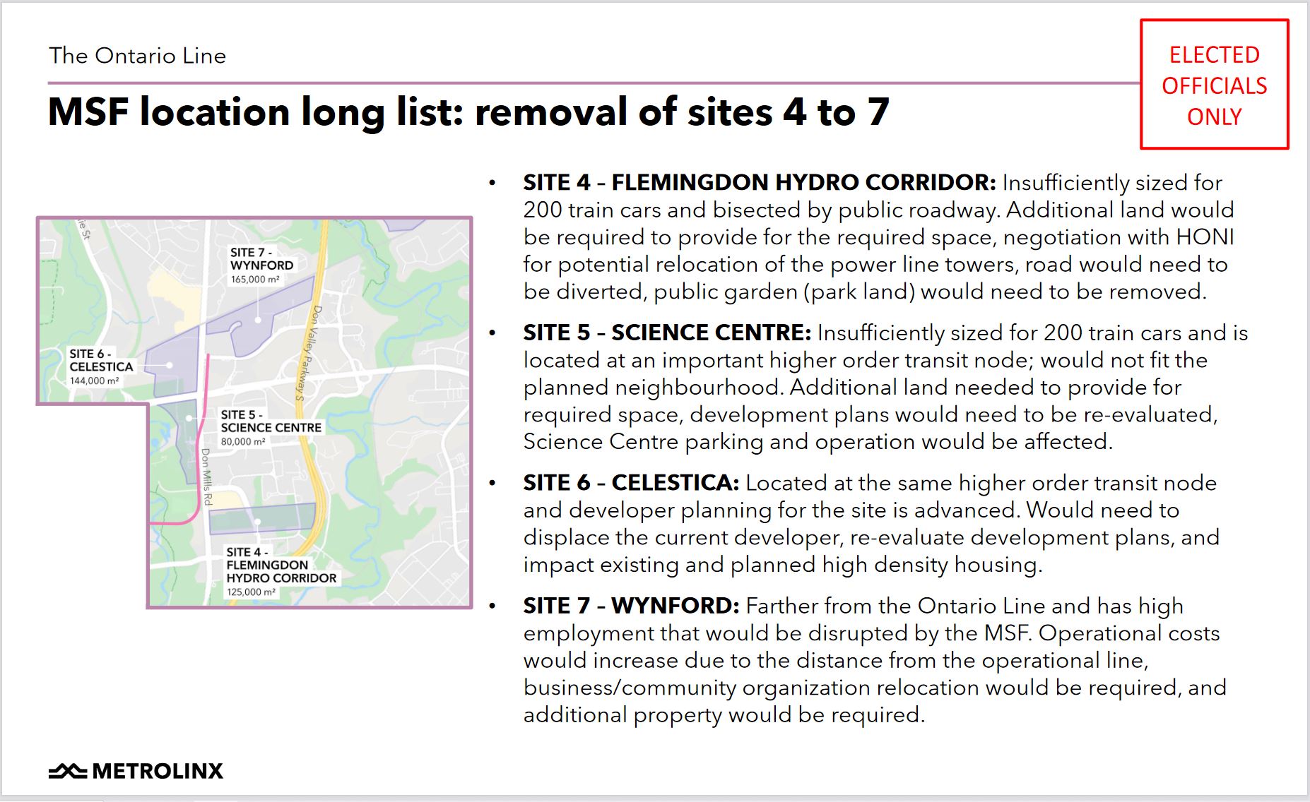
In the original Relief Line Subway plan, trains would have been stored and serviced at Greenwood Yard. This yard is too small for the projected Ontario Line fleet, an intriguing claim considering the relative demand and capacity on Line 2 (now served mainly from Greenwood) and the future Ontario Line.

This leaves three sites on either side of the CP rail corridor through Leaside. Each of these sites has its challenges.
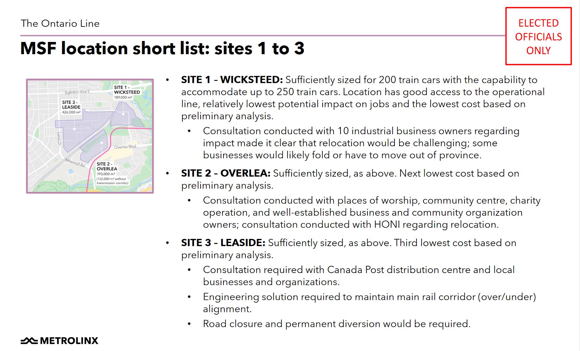
Metrolinx settled on using parts of site 1 (the southern part of the Wicksteed block), and site 2 (the northern part of the Overlea block).
In the previous article comments thread, a reader suggested placing the storage yard in Site 3 (the northeastern portion of the Leaside block). This requires an underpass at the CPR. It is not clear whether Metrolinx considered a hybrid Site 1-3 scheme that would not require the entire Leaside block, only enough room for the storage yard now planned for the northern portion of Site 2.

In the public meeting, Metrolinx stressed that they would be talking to affected businesses about support for relocation. The surprise expressed at this plan by members of the community suggests that consultation is comparatively recent although planning has been underway for some time.
The affected properties are shown in the map below.
The Islamic Society of Toronto plans to the move the Masjid Darussalam mosque from 4 Thorncliffe Park Drive to 20 Overlea Boulevard according to Metrolinx.
Metrolinx said that they are “keenly aware” of impacts to businesses and importance of Iqbal Foods (located in 2 Thorncliffe Park Drive) in the community. They are dedicated to work with all of the business owners to relocate “within the neighbourhood”. How much financial help will be involved remains to be seen. CEO Phil Verster said that it is “100% our intent” that these businesses are not lost to the local community.

Metrolinx received many complaints about timing of their announcement and holding the meeting during Ramadan in an area with a large Muslim population. They plan to hold more consultations after the holy month concludes in mid-May.

The overall project timeline for the North Section of the Ontario Line is summarized in the chart below.


If they are going to use the Overlea site, it seems odd that they aren’t proposing to use the space north of the Hydro corridor for some of the storage tracks which would reduce the amount of land to be expropriated south of the Hydro corridor.
Also odd is that the introduction is excited about elevated guideways over roadways for the North 1 Segment, but somehow elevated guideways are a problem when considering how to go over CP’s tracks to get to the prospective Leaside MSF site.
Also, it was interesting to see the 10min walking zones around the stations. The current sites of Thorncliffe and Flemington stations are within a 10min walk of a lot of parkland and about a third of Flemington’s catchment area is served by Science Centre. The original locations of Thorncliffe and Flemington stations would have had more people within a 10 minute walk and overlap among the station catchment areas would have been smaller.
Steve: Metrolinx is very good at picking its explanations from a bin where individual arguments sound fine, but they don’t when seen on the same page. Getting over or under the CP corridor should be relatively straightforward and should approached as a problem to be solved, not explained away. Remember that this is the same organization for whom across-the-platform transfers at Exhibition and East Harbour were an absolutely essential feature of the OL, until technical realities got in the way at which point the explanations changed to extolling the new designs.
Those catchment areas are similarly spoken of in the best possible light even though shifting Thorncliffe Park Station further west simply put more parkland into “walking distance” while carving off a slice of the main apartment area, and those maps in general do not take into account street layouts and walking paths.
If they spent less time spinning everything into the best possible light, particularly their own expertise, and more on truly engaging with people to work through problems and alternatives, they might get a lot more done.
LikeLike
OL MSF sites map #3: “TTC Western Yard (Obico) must be commissioned prior to start of Greenwood Yard demolition.” Also: “Significant additional budget ($1.5 -2 billion) … and cost escalations due to delay.” And much more.
So, while Metrolinx and the regime at Queens Park claim to want to reduce costs of the Ontario Line by using a subway-incompatible (and, yet unknown) light rail system, we see that there are new additional costs by doing so.
Steve: You are not supposed to notice things like that. The Ontario Line has two purposes: make Doug Ford look like a transit visionary, and cement Metrolinx’ position as an agency that can deliver good news for the government.
LikeLiked by 1 person
What would the cost be to tunnel under the rail line to the Greenwood yard, roughly speaking?
Steve: It’s about 900m from Pape at the rail corridor east to Greenwood Yard, so maybe $250 million? There are no stations, and this would be built as an adjunct to the OL tunnel project. A grade separated junction would not be needed as the track would only be used for carhouse moves. The big cost is in the need to shift all of Greenwood’s current operations to Obico immediately rather than at a future date when the TTC finally decides to proceed with the project, and the fact that the TTC would lose the benefit of having a yard on both the west and east end of the subway. Note also that Greenwood is planned to be a major depot for works equipment even if Obico becomes the primary yard for revenue service, and that function would be lost if Greenwood was fully dedicated to the OL.
LikeLike
I asked Metrolinx about putting some of the site on the Leaside area, going over or under the CP Rail. This is what they wrote back. I am not an expert on this, hopefully some folks here have comments:
Steve: It is quite amusing that Metrolinx now cites a 3-4% grade restriction considering that they trumpeted the ability to handle 5% grades with their “new technology” as an example of its superiority over conventional subways (that old fashioned stuff they claimed the TTC was using). One by one the supposed benefits of their scheme fall like leaves from a tree.
LikeLiked by 1 person
Not sure this fits here but Metrolinx has announced details of Don Valley layover.
Steve: This is a separate issue and there are community groups fighting it too. It is another example of how Metrolinx changes their explanations of what can and cannot work depending on the argument-de-jour.
LikeLike
Here are my thoughts on the not-so “Open House” by Metrolinx on April 15, 2021:
(1) Don’t “spin” our Tno Thorncliffe/ Flemingdon Health Centre community vaccination efforts in COLLABORATION with Michael Garron Hospital as a “Safety moment”. The places you want to expropriate are exactly where people were lining up to get vaccinated. You are removing a community hub. You are causing more harm than good.
(2) Ontario Line Metrolinx released a set of slides for “Elected Officials only” prior to the presentation. We downloaded them and have access to them. Why not share this information publicly?
(3) Elected officials (Rob Oliphant, Kathleen Wynne, Michael Coteau and Jaye Robinson) should be acting in the best interest of their constituents, not in favour of Metrolinx. Although Metrolinx took the “official” slide deck down, we have receipts! Thanks to upstanders like Steve & Omar.
(4) Metrolinx needs to explain why elevated guideways over roadways for the North 1 Segment are feasible, but elevated guideways are a problem when going over CP’s tracks to get to the Leaside MSF site. #MoveTheMSF (a few folks have asked this and gotten responses from Metrolinx, can someone please explain in layman’s terms?)
(5) Where are the minutes from the October 2020 Metrolinx consultation with the community? Who attended? What was discussed? What key decisions were made?
(6) Don’t call this a meeting. It was a tone deaf, patronizing, one-directional, PR stunt. You scheduled a “meeting” with 1 week notice, during a global pandemic (in an area with high burden of disease), in only English, in the most inaccessible format (160 character chat box)…during Ramadan, an hour and a half before sunset. The Islamic Society of Toronto does not speak for me, or for anyone else impacted by the expropriation. Your “consultation” is shameful and disrespectful.
On a side note, I have never experienced such a soul crushing Ramadan. After yesterday’s new lockdown/carding measures, and now free-reign to “Crown” construction, I’m not sure what to expect from the government and/or Metrolinx.
LikeLiked by 1 person
Fair enough as a reason for not splitting the MSF & yard across the rail corridor, but doesn’t that have other implications for the area?
A ground level MSF implies that the line (or maybe just the service connection?) will cross Beth Nealson Drive at-grade, which might be a problem at the eventual 90 second headway?
Steve: The track layout in the map does not assume ground level for the main line track but it’s unclear how they get down from that level to the yard. Conversely, if they are already in the air, that’s a smaller climb to go over the CPR. What is needed is a plan showing how the site would work and elevations of both tracks ad other surrounding features.
And is 3-4% grade enough to go from a deep-bore tunnel portal under Minton Place to elevated on the south side of Millwood & Overlea? The valley crossing is around 450m long, which works out to a maximum vertical change of 13.5m to 18m, which seems a bit tight?
Steve: Minton Place is the extraction site and so the tunnel will be fairly close to the surface at that point and only needs to get high enough by the north side of the Leaside Bridge to cross Millwood and get to the north side of Overlea Blvd.
Are there big pipes under Overlea Blvd that prevent running in a shallow cut-and-cover trench under one side of the road and then turning North through the Costco parking lot to a sunken MSF? That would seem to protect the businesses, allow splitting the MSF & yard across the CP line and grade-separate the Beth Nealson crossing.
Steve: I’m not sure about under Overlea itself, but the line is proposed to run over the north side of the street in front of the buildings. This alignment if underground might interfere with services to those buildings, but not with anything under Overlea itself. The crossing at Thorncliffe Park Drive West might be troublesome, but as long as the station at that location stays out of the intersection, they should be able to duck under utilities.
A general issue is that Metrolinx needs to settle on what sort of grades its technology will use for design purposes. They bragged quite a lot that they could do better than subways for which 3% is the preferred maximum, and could get to 5%, but I don’t think this appears in any printed materials. Now, they use steep grades as an argument against moving between levels.
LikeLike
Many thanks to Steve and commenters. While it’s complex, especially through Thorncliffe, we are really needing to do much, much better, in particular with reading the concerns/comments of both Nazerah and Omar. As it sometimes smells like there’s only fluff/canned response from Metrostinx, we are desperately needing this forum, and Steve’s depth of memory/resource, and it’s quite possible to cut/paste comments and send them along to various pols, though yup, it all reminds me of an old cartoon captioned ‘Preparing for consultation’, where an old guy has a good large ear brush going in to one ear, and out the other to ensure good passage.
So with the massive deficits at all levels, (not including the moral/ethical/brainsl bankruptcy that I can feel at the majority-of-Clowncil level which may be part of Dougtator’s Bill 5 smash-up, yes), we really might need to squeeze the billions better. And there’s still a massive decline in ridership, more on the GO than TTC, in some places.
We need to get towards the vision of c. 1997 of Metro’s last Official Plan which put the ball to GO to do an EA to connect GO Richmond Hill to Eglinton/Don Mills, one way or the other. If we had more of a plan, or re-discovered old ones, maybe this would change location of both yards – a good idea perhaps. (If we could kill off the Indy, hmm, maybe it’d be quite OK to have a yard on or below the HUGE parking lots/asphalt of Exhibition Place 😉
There’s also the 1957 plan; and I’m favouring triage of some well-resourced north-south focussed Relief connecting from Oriole via Eglinton and Thorncliffe to the core/near-core, via the Don Valley, and cutting out the costly tunnelling via Pape etc. and the surface tracks and a detour to Don Mouth, and do a second line, which might be better as a straight-line on King as per what the TTC wanted c. decade ago.
But it’s very good that there’s real interest in getting something up to Eglinton: that’s overdue – though the devil’s in details, and the details may come with a billion+ price tag, including not just piratization, but mis-matching of technologies, and can we trust the planning of both Mr. Ford and Metrolinx? Pandemic response – still missing the paid sick leave – says no, not at all.
(Oh, and with the lousy timing/meeting during Ramadan, is that a basis for a Human Rights complaint? Or really tackling the possible federal dollar supports?)
LikeLike
Thanks again, and pardon a bit more for improving Thorncliffe transit, some year, with good consultations. Extension of the St. Clair streetcar service eastward perhaps starting to go in a tunnel around Mount Pleasant, and with a bit of a bridge above creek level, and then ? to help with transit to the denser community of Thorncliffe. Obviously, we’re just spending a HUGE sum on Eglinton, and it’d be a larger construction project with some larger costs, but it’s a further way to help Thorncliffe. Not talking about extending it to connect to St. Clair Ave. E East, past the Don, but at least to Thorncliffe.
Steve: Getting across the Don at St. Clair is a huge project, and I don’t see how making another connection to Yonge north of Bloor is going to make much of a contribution. You are drawin lines on a map without thinking of how they would actually work.
LikeLike
And it seems others are peeved with it all: Ms. Wynne’s twitter feed and comments link.
Via David Miller’s feed and a suggestion that they butt out of more local planning vs. regional.
That still leaves the much-needed sub-regional services, which is likely the true relief ie. Oriole to Eglinton, to Thorncliffe, through Don Valley to core, perhaps some year link to Line 2, if on surface and PLANNED ie. something close to Broadview Station and maybe atop/on DVP.
Steve: Oriole to Eglinton is not going to happen because that line was abandoned years ago and would be very difficult to reactivate, not to mention problems with getting trains across the CP mainline to connect with the Don Branch. As for a connection with the BD subway at the Don Valley, that really is laughable. It is a long, difficult connection to Broadview Station, and by the time someone had transferred they could be at Union just by staying on the train.
LikeLike
I don’t view this as pandemic specific operations from Metrolinx. I’m thinking back to the OL community meeting from last year just prior to the start of the pandemic shutdown. Riverdale is a much wealthier neighbourhood than Thorncliffe Park and it was still a “no questions allowed” gathering. That’s just how Metrolinx operates.
Steve: It was also a meeting at which Richard Tucker, the big cheese of this project, refused to talk to me on the record as “media”. They have no idea of the damage they do to their credibility by not being open about plans and talking about, really discussing, not dismissing, alternatives. They expect everyone to be a cheerleader and are surprised when we don’t play our assigned roles.
This is one organization due for a major purge when their role model, the Premier, is deposed, although I must say that they were only marginally better under the Liberals.
LikeLike
Thanks Steve; pardon lack of clarity in words, especially with the idea for connection from GO at Oriole – was thinking of having it TTC-based, likely subway, as likely the GO would be a no-GO either on former shortcut now rail trail, or something direct and aligned with Don Mills. But having TTC do a sub-regional/near-express service might be very popular, and possible, in a more-ideal world/province.
And yes, had backburnered any real thought of extension of St. Clair to Thorncliffe area; but there is an eastern St. Clair Ave. E, so someone some century thought of grid completion.
Steve: St. Clair is a concession road, and the names were carried through even where they crossed valleys and were discontinuous. For example, Lawrence Avenue has a big gap but continues its name. Eglinton ended for a long time where Bayview is now, and then roughly at Brentcliffe, but the name goes all the way to eastern Scarborough.
Wilson and York Mills are an exception, possibly because “York Mills” was also a place, but even that name ends at Victoria Park. It’s the College/Carlton/Gerrard of the north just to confuse everyone.
Leslie Street exists in the east end (as in “Leslie Barns”), but has a huge gap from north of Gerrard at the CNR until it reappears briefly at Wicksteed, then settles in for a longer run north of Eglinton.
This is far more the mindset of the British Army surveyors than it is modern “planning” for an extension.
And, yes, I know about the “Leslie Street Extension” that was never built to connect from Eglinton to the Bayview Extension, but that was a modern project like the Spadina Expressway.
LikeLike
One of the East of Yonge difficulties is with the major grid discontinuity, combined with the shore of Lake Ontario squeezing that grid, where a diagonal is more suitable, eg, at least one other corridor. And yes, how to bridge valleys, as bridges are costly, as are tunnels? And it would help to have more Origin/Destination data, not that facts matter eg. many things.
With the OL, it seems that the federal level is avoiding being involved in any environmental screening ie. no federal level assessment, presuming that the provincial processes are sound, which is NOT the case, including avoiding the counting of concrete emissions in EAs, just as we don’t bother counting them in the City’s GHG budget, nor air travel, etc. But we’re ‘green’!
Honesty in GHG accounting is far more in Europe; Britain appears poised to begin to count the air travel emissions, and Paris itself has given an indicator that it’s a HUGE source, dwarfing much else, and they too have a large issue with building materials’ CO2, and presumably it’s not booming like here.
So the federal level is shirking responsibility; they too don’t want to measure concrete usages though it’s about 8% of global GHGs. If not for concrete, how could we get them re-elected without multiple infrastructure projects everywhere?
Even on the bike infra, mere paint no longer does it – concrete MUST be used, including where not really necessary, eg in front of Harbord Collegiate and also on Lansdowne, S of College. (Though at times yes, the concrete barriers are helpful, and more are needed, and it’s a very good material in so so many ways and places eg. housing etc.)
LikeLike
With regard to financial help for affected businesses and residents:
I emailed Metrolinx because I was curious about what was going to happen to 40 Beth Nealson, which is currently Access Storage East York. My family has had a storage unit here for about 15 years because we have no garage and our house is too small to store things like winter tires. Because the responsibility of moving ultimately falls to the renter of a storage unit, and because the East York location is quite affordable, I asked whether renters at Access Storage East York would be compensated for moving expenses, as well as if Metrolinx would help us locate new units at nearby facilities at a similar price to what we pay now. Their response to my email:
So…. yeah. There you go. I hope they’re in a better position when they come for your house.
LikeLike
Nice to have the tip about Access Storage being relatively OK/cheap; I have too much paper, and it’s not so organized as Steve’s certainly-fabulous archive, thanks.
Returning to a relatively ‘novel’ idea, and not necessarily appreciated by many – having some form of Maintenance/Storage likely below-grade at the Ex Grounds, and presuming that the transit theatre/tragedy of the last few years will likely wither soon with the extreme deficits, though we do need to invest in transit, a redesign of Relief more aligned with 1957 plan and the TTC’s c. 2012? plan of using King, not Queen, it makes more sense as we’ve had a long-standing issue of providing good transit capacity to the Ex/Ontario Place, and it might be an easy deke down from King, thereby solving two issues/birds with one stowin’ (yard).
LikeLike