Where Should A Relief Line (East) Go? (Updated)

Updated February 24, 2016 at 10:40 pm: A map showing the various options for a Pape-Queen routing to downtown has been added at the end of this article.

The City of Toronto Planning Division has released the detailed technical scoring for evaluation of six possible routes for a Relief Line linking the core area to the Danforth subway.

The possible routes that survived a preliminary cull were:

  • A: Broadview to Queen crossing the Don River at Queen
  • B1: Pape to Queen crossing the Don River at Queen
  • B2: Pape to Queen, dodging south to serve the Unilever site before crossing the Don and swinging back to Queen Street
  • C: Broadview to King crossing the Don River at Queen
  • D1: Pape to King crossing the Don River at Queen
  • D2: Pape to King crossing the Don River at the Unilever site

Of these, the two Broadview options don’t fare very well, and the real debate is between the four remaining Pape options.

The scoring extends through many categories and pages, but to simplify things and understand just how each factor was ranked, I have consolidated the scores into a spreadsheet. (For the detailed evaluation, refer to the scoring document linked above.)

ReliefLineAlignmentScoringSummary

In place of the scoring system used in the city summary, I have converted each of the symbols to a numeric value:

  • Full moon = 4 points
  • 3/4 moon = 3 points
  • Half moon = 2 points
  • 1/4 moon = 1 point
  • New moon = 0 points

Within each major grouping of scores, the values were totalled and then normalized to the range of zero to one. For example, if a group contained 4 topics, then the maximum possible score is 16, and each alignment’s score is divided 16 to get a normalized value. This allows the scores from each group to be compared with each other.

At the end, the scores can either be summer individually (each topic counts equally), or the group averages can be totalled (each group count equally regardless of how many topics it contains) and normalized.

On a grand total basis, both the city’s technical evaluation and public feedback came to the same conclusion: even though there are variations between the four alignments, they all average out to a 3/4 score.

The point scores also come out close to the same with higher values on one item balancing lower values on others for, overall, an even ranking.

Quite simply, all other things being equal, the four alignments are more or less equivalent using this scoring system. However, the City opted for alignment B1 because, among other things, is is claimed to be cheaper and simpler to build.

The costs estimates in the City’s evaluation [at p.19] are:

  • $3.7-billion for either of the Pape via Queen options regardless of whether they follow Queen or King to the core
  • $4.0-billion for the Pape-Unilever-King option
  • $4.1-billion for the Pape-Unilever-Queen option

The ridership estimates are generally higher for the via King options, and higher still for the routes serving the Unilever site. In all cases, off-peak riding tends to be low compared to the rest of the network with roughly 2/3 of all boardings on the Relief Line being during the AM or PM peak. The effect is even more striking for configuration where frequent SmartTrack service at 12 trains/hour competes with the Relief Line for customers. This demonstrates the problem of a line aimed at primarily peak period “relief”. As and when we see projections for longer versions of the RL (to Eglinton or Sheppard), the balance of off-peak travel may change because the route will serve new subway territory, not simply provide an alternate route for existing trips.

Despite the even scoring overall, the preferred corridor was selected based on giving some criteria additional weight as shown in the table below.

201602_ReliefLineB1Selection

This evaluation, like so much other recent work, depends very much on the presumed presence of frequent SmartTrack service in the rail corridor. If that is found to be impractical, then the relative importance of the RL changes along with its appropriate alignment to serve the core. This is particularly critical at the Unilever site which would have only SmartTrack serving it if the RL stays on Queen Street.

One point above misrepresents the technical evaluation: both of the Queen Street crossing routes have the same cost estimate regardless of which route they take to the core area (Queen or King) and they share the same river crossing characteristics.

In summary, the choice “makes sense” in the limited context that a frequent SmartTrack service will actually be feasible and will be built. If SmartTrack cannot be provided on a five minute headway with a low fare, then the entire planning process will require a major rethink.

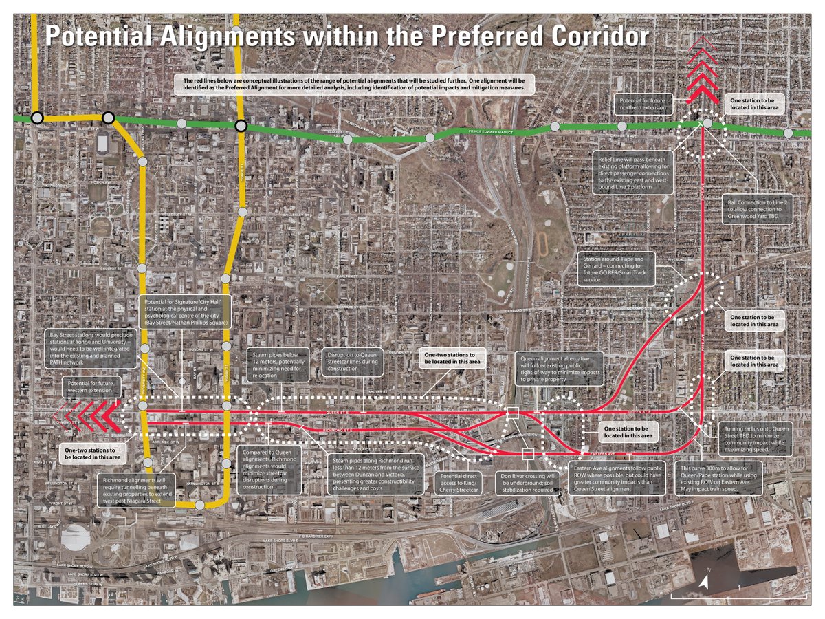
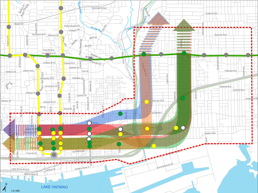
Updated February 24, 2016: The following map shows possible alignments for a route from Pape & Danforth to the core area. Notes on the map talk of a track connection at Danforth to provide access to Greenwood Yard. The technical scoring paper also mentions a southerly route under the rail corridor from Gerrard & Pape eastward. While this is longer, it would avoid the complexity of adding linking curves at Danforth.
201602_ReliefLinePapeOptions

Demand Projections for Relief Lines

The City of Toronto Planning Department has published a set of demand projections for various combinations of the (Downtown) Relief subway line, SmartTrack, and the proposed northern extension of the Yonge line to Richmond Hill.

This document makes interesting reading because it shows both the status of the evolving master transit plan that went into the modelling, and the vital point that additional capacity into the core area is essential to prevent complete gridlock on the subway system. Both SmartTrack and the Relief Line are essential to a future transit network.

That said, the report raises several issues in part by what it does not talk about, specifically some of the network configurations that have already been presented in various studies.

Alignment Options for the Relief Line, and Other Model Variations

This question of the Relief Line’s alignment is subdivided into two parts: what is the scope of the line, and which route will it take to link Danforth to the core area.

The big options include:

  • A “little J” route from Yonge Street to Danforth
  • A “big J” route from Yonge Street to at least Don Mills & Eglinton, possibly beyond
  • A “little U” from Danforth to Bloor West via downtown
  • A “big U” with northern extensions of one or both arms of the “little U”

Work has focussed on the “little J” because that is the scope for a Relief Line so long discussed, and approved for study by Council. Therefore the model numbers do not show any effect of taking the “little J” further north to intercept more traffic bound for the Yonge line. This has already been reported by Metrolinx as a very beneficial extension to the RL.

Within all of the options, there are permutations of a Danforth to Downtown route:

  • The north-south segment could lie on either Pape of Broadview.
  • The Don River crossing could be at Queen, or further south to allow the line to serve the Unilever site.
  • The route into the core could be via Queen or King.

A northern route via Queen makes for a simpler river crossing, but the southern route picks up a major new employment district. The King Street route into downtown also attracts more riders than a Queen route.

City Planning staff have erroneously talked of a King route as if it could only exist as part of the southerly Unilever site alignment, when their own study clearly shows the option of a route crossing the Don at Queen, and then veering into King Street. The more northerly crossing is preferred because it will be easier to build under the river at a narrower point.

RLAllCorridorsWeb

The following permutations were modelled to see how they would perform:

  • Broadview to Queen
  • Broadview to Queen to King
  • Pape to Queen
  • Pape to Queen via Unilever
  • Pape to Queen to King
  • Pape to King via Unilever

Of these, the two most promising were the Pape to Queen options with the only variation being whether the line ran to downtown via Queen or via King after crossing the Don at Queen Street. For this article, these are the only two whose demand projections I will discuss.

Further east, there is the question of the Scarborough Subway extension and SmartTrack. Model runs were performed with three variations:

  • No SmartTrack
  • SmartTrack on a 15 minute headway (4 trains/hour)
  • SmartTrack on a 5 minute headway (12 trains/hour)

The SmartTrack cases used a modified land use plan that assumed SmartTrack itself would cause growth that would not otherwise occur. This causes increases for the Relief Line’s projected demand when it is matched with a the lower level of SmartTrack service (4 trains/hour) because the latter does not attract as much riding as the Relief Line.

All model runs used a Scarborough Subway (SSE) with its original three stops, not the “optimized” version serving only Scarborough Town Centre. The disconnect between what is modelled and what is proposed indicates that some of the plan’s elements have changed very recently. The model is supposed to catch up to the plan in future iterations.

None of the SSE or ST figures are included in this report, and so we cannot see how the model divided up demand between them, albeit with the “wrong” station configuration.

Finally, the Richmond Hill extension was added to the model networks to see how it would affect demand on the critical downtown segment and Bloor Yonge Station.

All of these numbers must be taken with awareness of the limitations on what has been modelled, notably:

  • With the RL ending at Danforth, the potential benefit (and hence RL demand) of the “big J” is unknown.
  • The five-minute service on SmartTrack, identified in a previous study as essential to attract riders, may not be physically possible given constraints on sharing the network with GO.
  • It is unclear whether SmartTrack will actually operate at no fare premium above local TTC services, another essential component of making this service attractive to riders.
  • The effect of SmartTrack in the downtown segment, including the degree to which it would duplicate an RL at the Unilever site, depends on the ability to operate frequent ST service.
  • The relative roles of the Scarborough Subway and SmartTrack in attracting riders is unknown because the now-proposed station layout has not been modelled.

That is a long list of variables. Many of these will be addressed in updated model runs expected in coming weeks, but readers should be careful not to take the current model output as definitive.

Nonetheless, the report concludes that treating SmartTrack and the Relief Line as options is misguided because both will be required to accommodate future demand to 2031 and beyond. Addition of the Richmond Hill extension to the mix will exhaust the Yonge line’s capacity by 2041. This makes further study of the “big J” quite important.

The findings in this Summary Report make clear the importance of the Relief Line. It is apparent that both the Relief Line and SmartTrack will be required in the future to ensure the efficient operation of the existing and proposed future transit networks. Additional work is required to assess the potential benefits of extending the proposed Relief Line north of the Bloor-Danforth subway to Eglinton Avenue and potentially to Sheppard Avenue. [p 3]

Continue reading

A Rainbow of Rapid Transit

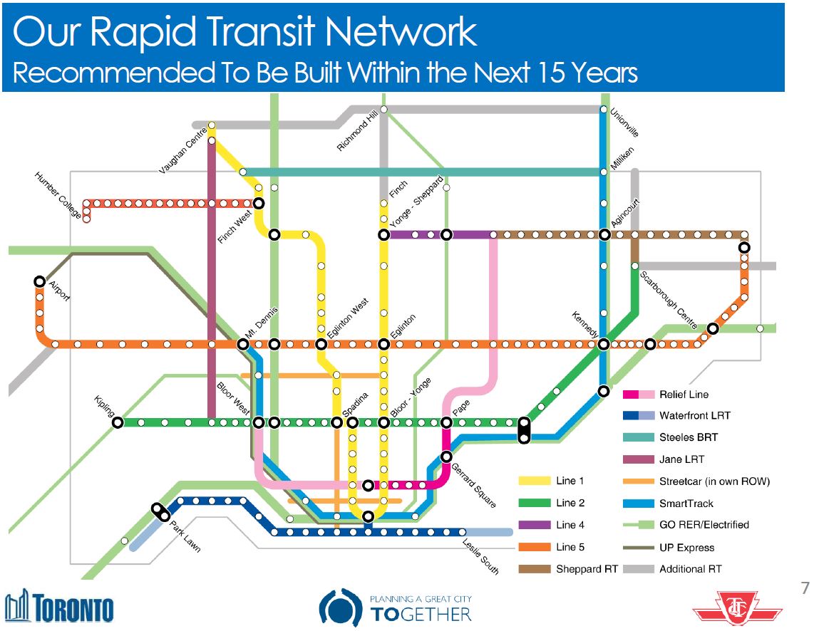
In Toronto’s never-ending fascination with new transit maps, the City Planning department has released a vision for our rapid transit network as it will be in 15 years.

201602_15YrPlan

Despite much talk of “evidence-based” planning, this is a very political map, and I cannot help remembering then-Premier David Peterson’s announcement of 1990 (not long before he lost an election and Bob Rae wound up as his much-surprised replacement) that amounted to a chicken-in-every-pot map.

There is nothing wrong with network-based planning, and indeed I have been beating a well-worn drum on that subject for years. But let us also remember that the Scarborough Subway exists because of the political clout of Brad Duguid, a former City Councillor, now Ontario’s Minister of Economic Development. Mayor John Tory, in Toronto Life, cites Duguid as saying that “if anyone tries to cancel the [Scarborough] subway, they’ll do it over his dead body”. “Evidence” apparently includes having a large cudgel to keep wandering pols in line.

The map also includes the Mayor’s pet project, SmartTrack, and it’s no wonder that he steers clear of the Minister’s position given the need for a provincial agency, Metrolinx, to accommodate SmartTrack on their network.

All of this is part of the “Motherlode” of public consultation sessions now running in various places around the City, and through Metrolinx in the wider GTHA. Background information and links to related material are available at Toronto’s TransitTO web site.

Continue reading

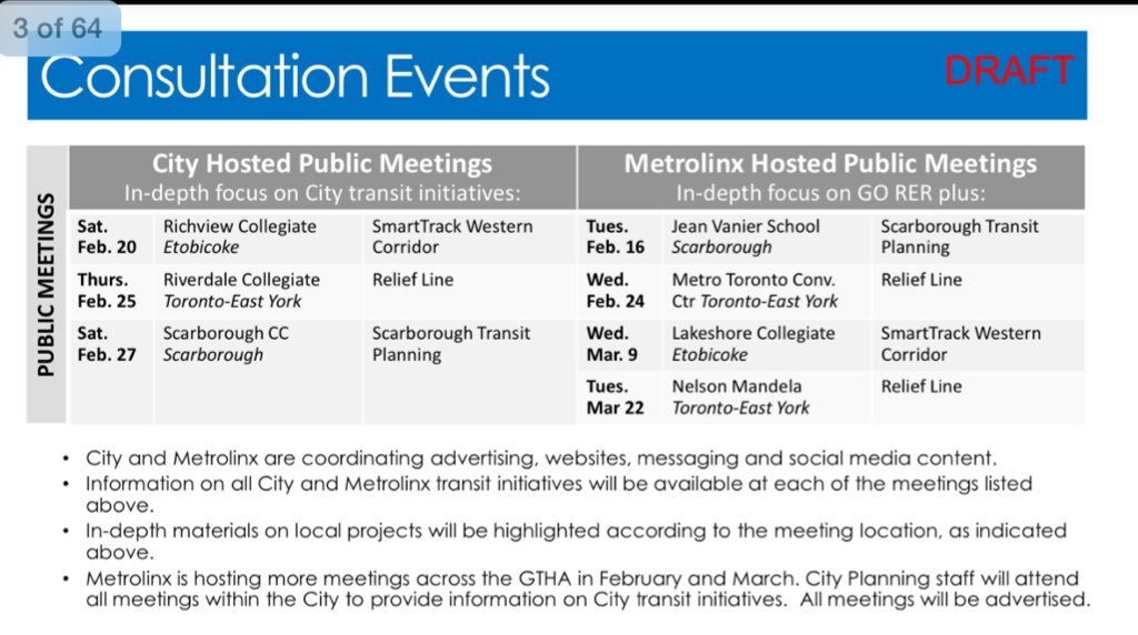
Relief Line, SmartTrack, GO/RER, Scarborough Subway Consultations

Toronto City Planning has released a draft list of upcoming public consultations on various transit plans including:

  • The Relief Line
  • The Scarborough Transit Plan (Subway, SmartTrack, Crosstown East LRT)
  • The Western SmartTrack Plan (SmartTrack, Crosstown West LRT)

2016_ConsultationCalendar

Additional meetings and information about Metrolinx plans (GO Regional Express Rail) will be organized by that agency.

Even more information will be available in March 2016 when the City releases a compendium report on all transit initiatives currently under study. These will include items listed above as well as the “Waterfront Reset” study, TTC Fare Integration proposals and a review of how (or if) Tax Increment Financing can contribute to the many transit projects under review. The intent is that this report will form the basis for public consultation and debate leading to recommendations at Council in June 2016. This is a very aggressive schedule, and there is no indication how consensus will actually be achieved in so short a time, especially with the usually-secretive Metrolinx as an essential player. At least the discussion will be at a network level, not ward-by-ward with a “relief” line for every member of Council, and there will be some filtering of various schemes based on engineering and operational realities.

What is sadly missing from all of this is a discussion of day-to-day transit operations and the backlog in the state-of-good-repair budget. We can blithely discuss billions worth of subway building to Scarborough and a Relief line, but Council won’t fund the basics of running a transit system.

Toronto Relief Line Alliance Launched

The recently-formed Toronto Relief Line Alliance has  just launched a campaign to showcase the benefits of a new subway line from downtown Toronto to Don Mills & Sheppard. Unlike the less-than-arms-length SmartTrack advocates, FAST, the Relief Line Alliance isn’t trying to make any politicians look good or prop up the remnants of an ill-considered election platform.

Of particular interest on their site is a map where readers can see travel time savings possible for various trips to downtown. All of the numbers they use are based on published reports notably Metrolinx’ own evaluation of such a route from June 2015.

Now that Toronto can finally discuss something other than John Tory’s signature project, the new Alliance can provide a voice and a forum for a much-needed part of our transit system.

City Hall and Queen’s Park must get their heads out of the sand and make the Relief Line an integral part of medium term, “see it in our lifetime” plans. The time for transit plans pandering to pet projects and political egos is over.

TTC Budget Meeting: November 9, 2015 (Updated)

Updated November 10, 2015 at 6:00 pm:

The Budget Committee meeting was not the best-organized or well-informed of TTC meetings thanks to a combination of factors. It was held in the boardroom at TTC headquarters which is no longer configured suitably for such events and cannot handle a large presence by the media who were out in force anticipating a story about 2016 fares. Almost all of the material was presented by one person who, unfortunately, trusted to memory rather too often and got the odd fact wrong as the meeting wore on. Moreover, there simply was too much material to absorb in the manner it was presented.

Committee members, for their part, tended to view the situation through their personal lenses of which hobbyhorse needed attention. This did not necessarily make for a broad view of TTC issues, and many erroneous assumptions, often uncorrected, crept into the debate.

We will go through this and much more all over again at the November 23, 2015 meeting of the full Board when we can also expect a very long parade of deputations on the subject of fares.

The entire exercise of having a Budget Committee has been useful, up to a point, in that some Commissioners have been exposed to the gory details, but they remain confused, and we have yet to see an actual philosophical discussion of just what the TTC should be as a basis for the budgets for 2016 and beyond.

The following motions were approved by the Committee:

Continue reading

A Smarter SmartTrack

The SmartTrack scheme was born of an election campaign, but it was John Tory’s signature project, one he is loathe to relinquish despite its shortcomings.

What’s that you say? I am just being one of those “downers” who cannot see our manifest destiny? What’s that line about patriotism and scoundrels?

At the recent Executive Committee meeting, Tory actually had the gall to say that during the campaign, he didn’t have access to a squad of experts and had to make do with the people he had. Funny that. This is the crowd that estimated construction costs on the back of an envelope, who “surveyed” the line using out of date Google images, who ignored basics of railway engineering and capacity planning to make outrageous claims for their scheme.

When the dust settled and John Tory became Mayor Tory, I thought, ok, he will adapt his plan. Indeed, it didn’t take long for a reversal on TTC bus service and the recognition that Rob Ford had stripped the cupboard bare and then started to burn the lumber at the TTC. A campaign attack on Olivia Chow’s (far too meagre) bus plan changed into championing the restoration of TTC service to the days of the “Ridership Growth Strategy” and beyond. Good on the Mayor, I thought, he can actually change his mind.

SmartTrack is another matter, and what Tory, what Toronto desperately needs is a fresh look at what GO, SmartTrack and the TTC could be if only the fiefdoms and the pettiness of clinging to individual schemes could be unlocked. That would take some leadership. I wonder who has any?

Inevitably comments like this bring out the trolls who say “so what would YOU do” (that’s the polite version). Here’s my response as a scheme that bears at least as much importance as a way of looking at our transit network as the competing visions in the Mayor’s Office, Metrolinx, City Planning and the TTC.

Continue reading

SmartTrack Update: Many Reports, Many Unanswered Questions (Updated)

Updated October 21, 2015 at 9:30 am:

The Executive Committee spent a few hours discussing this report. As the morning wore on, it was clear that Mayor Tory was becoming unhappy with questions about his scheme. By the end of the debate when he spoke, he said:

I think a number of the questions raised by members of council today are perfectly legitimate questions which I’m sure our staff have taken note of and if they weren’t already being asked and answered, those questions, they will now be.  I just hope and I sense a generally positive sort of sense around here but I hope that we don’t get into being either sort of Douglas or Debbie Downer about these things. [Adapted from a quotation in the Toronto Sun]

Tory went on to say that he had “a mandate” from voters to build SmartTrack in a manner distressingly reminiscent of Rob Ford’s “mandate” to tear up Transit City. The problem with both claims is that voters did not elect Tory or Ford for those specific purposes, but in a reaction against the previous administrations, particularly in Tory’s case. Moreover, that “mandate” does not mean that the platform necessarily made sense as proposed, only that it was an attraction to voters that a candidate had concrete ambitions. We have already seen Tory backtrack on his claims that Toronto did not need more bus service (responding to Olivia Chow’s half-hearted support for transit), and there is no reason for SmartTrack to be treated as a divine plan on stone tablets.

As answers from staff to various questions made abundantly clear, there is a lot of work to do between now and first quarter 2016 when all of the details are supposed to return to Council. Staff went out of their way to avoid giving any indication of the way preliminary work might be headed lest they be drawn into a debate about “conclusions” before the supporting studies are in place.

The Executive Committee made a few amendments to the report’s recommendations:

1.  Requested the City Manager to forward the report (October 15, 2015) from the City Manager for information to the Toronto Transit Commission, the Ministry of Transportation, Metrolinx, the City of Mississauga and York Region.

2.  Requested the Chief Planner and Executive Director, City Planning to report to the Planning and Growth Management Committee on the results of the public consultations arising from the Preliminary Assessments of the Smart Track Stations, as set out in Appendix 2 to the report (October 15, 2015) from the City Manager, particularly with respect to the development potential of new stations.

3.  Requested the City Manager to work with Toronto Transit Commission, Metrolinx, and GO Transit, to develop a One Map Strategy where by major intersections and/routes of these transit operators are shown on future hard copy and electronic local and regional transit maps, once SmartTrack routes and stations are established.

The first recommendation is the original staff proposal simply to transmit the update report to other agencies. The second arose from a concern by Councillor Shiner, chair of the Planning & Growth Management Committee, that implications of and potential for redevelopment around SmartTrack stations be understood as soon as possible. During debate, he spoke about the success of development a long the Sheppard line, an ironic stance considering how strongly he had opposed development around Bayview Station when it was at the design stage.

The third recommendation arose from Councillor Pasternak, who never tires of advocating the “North York Relief Line” (otherwise known as the Sheppard West extension to Downsview). His desire is that maps show all of the projects that are in the pipeline during studies, not just the one that happens to be the subject of debate.

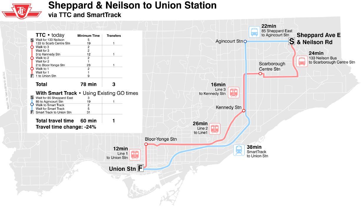
A notable absence in the staff presentation was any reference to the Scarborough Subway Extension as an alternative route for travel to downtown. That presentation covered substantially the same information as the background reports, but it included a few new charts about comparative travel times with SmartTrack in place.

STvsTTC_TravelTimes1

The important difference between this map [at p23] and the Tory SmartTracker website (which shows comparative travel times) is that the TTC includes the access and wait times for SmartTrack in its calculations. This reduces the proportionate saving over a trip. Another issue, of course, is that many riders do not work at Union Station, and taking SmartTrack there would be an out-of-the-way trip. This is not to downplay what SmartTrack might do, but to point out that if ST is to be part of a “network”, then advocacy for it must look at how it benefits all of the trips originating in some part of the city (say northeast Scarborough), not just those that conveniently lie on its route. This will be an issue in comparative ridership projections for ST and the Scarborough Subway Extension because those who are bound for midtown will almost certainly have a shorter trip simply by taking the subway rather than ST.

The original article follows below:

Continue reading

A Frustrating Update on Transit Expansion Plans

The TTC Board received an update from City and TTC staff on the status of major transit expansion plans in Toronto at its meeting of September 28. The presentation was largely delivered by Deputy City Manager John Livey with backup from Mitch Stambler, TTC’s Head of Service Planning. Also at the table, but notable for her silence, was the Toronto’s Chief Planner Jennifer Keesmaat. A contingent from Metrolinx, another agency studying transit expansion, was in the public gallery, but they did not participate in the presentation or discussion.

This session was a prologue for a report coming to Toronto’s Executive Committee on October 20, 2015, but a great deal of detail remains to be fleshed out. This proved frustrating for the Board members on two counts. First, the lack of detail prevented the TTC from making informed comment on the plans, and second, the process itself has largely bypassed the TTC Board and concentrated work at the City and Metrolinx.

To some extent, the TTC has itself to blame for this situation. During the Ford/Stintz era, meaningful policy debates at the TTC were rare, and the TTC ceded responsibility for large scale planning to the City of Toronto under Keesmaat’s department. At the political level, staying informed about issues is a comparatively new desire by Board members (not to mention some members of City Council) when the issues are more complex than a dumbed-down subways-subways-subways mantra. They have a lot of catching up to do.

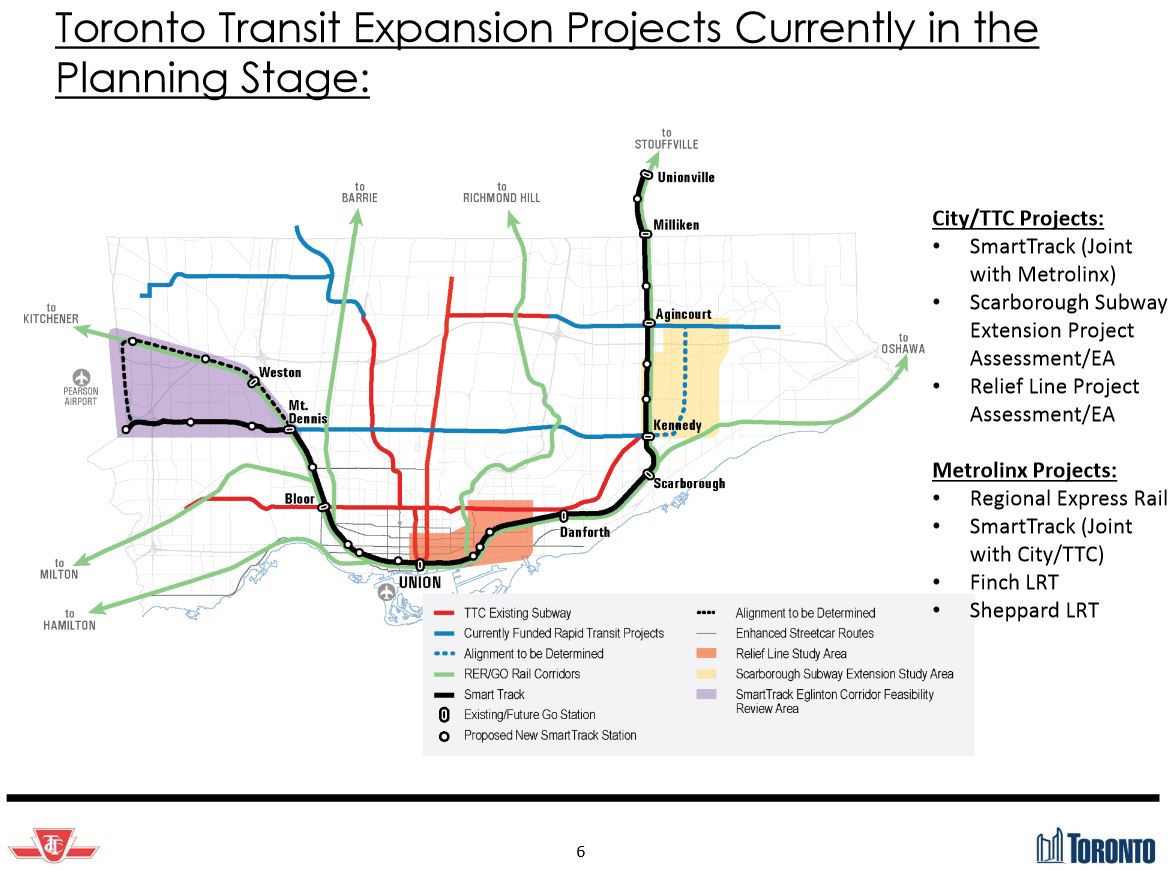
Detailed reports on four major projects will come before the TTC and Council over coming months, and these will inundate members with not only a great deal of information but force some hard decisions about just which projects, and at what scale, the City should pursue. These are:

  • The Relief Line
  • The Scarborough Subway Extension
  • Waterfront transit
  • GO/RER, SmartTrack and TTC service integration

ExpansionPlanMap_6

The situation is complicated by parallel work at Metrolinx, an agency with very different goals from the TTC and the City, and by the inevitable political wrangling over the relative importance of projects. Whether any reports coming forward from staff will be trusted, especially in an environment where Councillors and the Mayor routinely dismiss “expert” advice that does not suit their biases, remains to be seen. Equally difficult will be the question of whether the reports are spun, in advance, to suit specific outcomes rather than presenting “just the facts”.

One difficulty already lurking in the wings is the question of demand modelling. The University of Toronto together with City Planning is developing a new model for GTHA travel. This is much more ambitious than current models in that it covers the entire region and models travel over the entire day, rather than focussing on AM peak flows. The model also allows for route and mode choice by incorporating considerations of fares and line capacity (crowding). At this point, the model is still being calibrated and validated, a process that uses known historical data (from the 2011 Transportation Tomorrow Survey) to confirm whether the model generates flows that accurately mimic what actually happened. (The TTS is conducted every five years by UofT on behalf of municipal and provincial agencies, and the next set of data will reflect demands in 2016.)

Draft results for the new projects and network will not be available until October 2015, and a report on details will not come to Council until the first quarter of 2016. One suspicion is inevitable given this delay: is the “calibration” intended to produce a desired outcome? That’s a tricky question both because it speaks to the independence of the process and also to the way in which the model is used. For example, a model may well reproduce past behaviour perfectly, but that’s a known target and the context for it (then-existing transit, road and land use configurations) are a matter of record.

Future modelling depends not only on the nuts and bolts of the model itself, but of the assumptions put into its configuration. A well-known example of flawed modelling was for the Sheppard Subway in which unduly rosy assumptions about job numbers and locations gave the subway a projected demand well above what it actually achieved. The further one goes into the future, the cloudier the view becomes, and the presumed distribution of population and employment can involve political as well as basic economic dimensions. If, for example, the concentration of jobs in the core area and the polarization of high and low income housing concentrations continues, this has profound effects on future demand. Moreover, such concentration may not suit politicians who view their own turf as the rightful place for future growth.

Continue reading

Yonge Relief Network Study: June 2015 Update

At its board meeting on June 25, 2015, Metrolinx will consider an update on the study of capacity relief for the Yonge Street Corridor in Toronto.

The report states that projected demand on the Yonge line can be handled for the next 15 years:

1.a. Significant relief to the Yonge Subway will be achieved with currently committed transit improvements underway including:

i. TTC’s automatic train control and new subway trains;

ii. The Toronto-York Spadina Subway Extension; and

iii. GO Regional Express Rail

1.b. Based on [the] above, more rapid transit service and capacity that is currently funded and being implemented will meet the future 15 year demand, assuming current forecasts on the growth rate of downtown employment and the implementation of TTC automatic train control on the Yonge Subway.

Continued work is recommended:

2. Direct the Metrolinx CEO to work with the City of Toronto City Manager and the TTC CEO to develop an integrated approach to advance the Relief Line project planning and development, incorporating further business case analysis and the findings of the Yonge Relief Network Study to:

  • further assess the extension north to Sheppard Avenue East to identify a preferred project concept,
  • inform the planning underway by the City of Toronto and TTC to identify stations and an alignment for the Relief Line from Danforth to the Downtown area
  • continue to engage the public in this work as it develops

3. Direct staff to work in consultation with York Region, City of Toronto and the TTC to advance the project development of the Yonge North Subway Extension to 15% preliminary design and engineering.

The emergence of a variation on the Relief Line that would operate north to Sheppard is quite a change from days when even getting discussion of a line north of Eglinton was a challenge. The context for this emerges by looking at the alternatives for “relief” that were considered and how they performed.

The next report to the Metrolinx Board will be in Spring 2016. The challenge will be to keep planning for a Relief Line “on track” in the face of the excitement and political pressures for GO RER, SmartTrack and a Richmond Hill Subway.

Continue reading