There’s A New Subway On The Way (3)

By mid 1964, the University subway had been running for over a year, and the Bloor-Danforth line’s opening was set for early 1966. Extensions to the east and west were already approved, although the Etobicoke segment ended at Montgomery Road on the east side of Mimico Creek. This would later be changed to Islington, and the stations at Prince Edward and at Montgomery were consolidated into a single stop at Royal York.

With most of the line built by cut-and-cover, work was underway in many locations simultaneously, aided by the final added funding contribution from the Metro Toronto government. Unlike more recent projects, where political wrangling and tax saving measures dictated that construction run as slowly as possible, the BD line’s construction was a high priority in its day.

Yorkville became the centre of Toronto’s 60’s culture, complete with an endless stream of tourists driving through to gawk at the hippies through closed windows. The name had such an unsavoury reputation for up-tight pols that in time the station would be renamed “Bay” with “Yorkville” as a subheading. Now it is one of the poshest areas in the city.

A fleet of 164 subway cars was on order. These were the “H-1” trains as they would be known after their manufacturer, Hawker-Siddeley, at what is now the Thunder Bay plant of Bombardier.

A Rainbow of Rapid Transit

In Toronto’s never-ending fascination with new transit maps, the City Planning department has released a vision for our rapid transit network as it will be in 15 years.

201602_15YrPlan

Despite much talk of “evidence-based” planning, this is a very political map, and I cannot help remembering then-Premier David Peterson’s announcement of 1990 (not long before he lost an election and Bob Rae wound up as his much-surprised replacement) that amounted to a chicken-in-every-pot map.

There is nothing wrong with network-based planning, and indeed I have been beating a well-worn drum on that subject for years. But let us also remember that the Scarborough Subway exists because of the political clout of Brad Duguid, a former City Councillor, now Ontario’s Minister of Economic Development. Mayor John Tory, in Toronto Life, cites Duguid as saying that “if anyone tries to cancel the [Scarborough] subway, they’ll do it over his dead body”. “Evidence” apparently includes having a large cudgel to keep wandering pols in line.

The map also includes the Mayor’s pet project, SmartTrack, and it’s no wonder that he steers clear of the Minister’s position given the need for a provincial agency, Metrolinx, to accommodate SmartTrack on their network.

All of this is part of the “Motherlode” of public consultation sessions now running in various places around the City, and through Metrolinx in the wider GTHA. Background information and links to related material are available at Toronto’s TransitTO web site.

Continue reading

There’s A New Subway On The Way (2)

As construction progressed on the Bloor-Danforth-University subway, the TTC issued progress reports from time to time.

Progress Report 3 predates the opening of the University leg of the project. By this time, a funding contribution from Queen’s Park brought the then estimated completion date back from 1969 to 1967.

The first batch of aluminum 75-foot cars, a form that would become standard for Toronto, came from Montreal Locomotive Works. All subsequent orders went to the plant in Thunder Bay now owned by Bombardier.

There’s A New Subway On The Way

With all the hoopla about yet another new transit plan for Toronto, it’s time to remember that the 50th birthday of the Bloor-Danforth subway is coming up in a week’s time. Depending on which event you consider the “real” birthday, it will either be Thursday, February 25 (the anniversary of the ceremonial opening) or Friday, February 26 (the first day of revenue service).

Over the next week I will post some ephemera from that era when Toronto launched on a major subway building project.

The handout below was a publicity piece for the Bloor-Danforth-University subway project. Among items of interest are:

  • The expected construction time was 9 years broken down as the University Line (3.5), Greenwood to University including Greenwood Yard (4), and the remaining pieces east from Greenwood to Woodbine, and West from St. George to Keele (2.5). Almost all of the line was built cut-and-cover , and the city expropriated a swath of houses along most of the route to the north of Bloor Street and Danforth Avenue. This strip is now home to parking lots, a few parks, subway entrances, and the occasional new building sitting right on top of the subway.
  • The original completion date to the terminals at Woodbine and Keele was planned to be 1969, but work was accelerated thanks to additional funding from the Metropolitan Toronto government and Queen’s Park.
  • The paintings showing what the new stations would look like date from 1956 and 1957, before the project had been approved by Metro Council.
  • The map of the route includes the original names for most of the stations including Vincent, Walmer and Yorkville. By the time this was printed, “Willowvale” Station had already changed to “Christie”, but the park to the west retained its original name.

The station illustrations are by Sigmund Serafin whose work also shows up in samples of the original Yonge line station designs. Of the four stations shown here, none was built exactly as shown. You can see the full set on Transit Toronto. The eight water colours were rescued from a housecleaning binge at the TTC in the late 1960s when much material went into various private collections lest it simply disappear. These paintings are now back with the TTC who plan to issue them as posters later this year, and the originals will go to the City Archives.

Here is Bloor-Yonge Station in all its mid-50s glory, with Gloucester trains, no Hudson’s Bay building and a lot of Bloor-Yonge streetscape that has vanished over the years.

Yonge_Station_Serafin_1957w

For a detailed history of the Bloor subway, visit Transit Toronto.

How Will SmartTrack and GO/RER Co-exist?

Metrolinx has published an update on studies of how the proposed SmartTrack service will be integrated with its own GO/RER (Regional Express Rail) offering. This will be considered at their board meeting on February 10.

This covers several issues, and begins to nail down just what SmartTrack might, or might not, resemble that is beyond the scale of postcard election literature. As we already know, major changes are planned to the western leg where the Crosstown West LRT will take over the function proposed for SmartTrack beyond Mt. Dennis. To the east, SmartTrack remains in the GO Stouffville corridor, but the Scarborough Subway Extension (SSE) has been scaled back to a one-stop line serving only the Town Centre, and the Crosstown East LRT will provide service to eastern Scarborough.

What is GO RER?

WhatIsRER

This graphic is amusing for its complete contrast with the way that Metrolinx/GO presented electrification of their services during early days of public consultation. That hit a low point when it was suggested that electric trains might not work in snow.

Note that the official line now is that lots of cities use this type of service, and that electrification is an integral part of the package.

Metrolinx owes us all an apology for their initial foot-dragging and misinformation campaign. Now if only they had been more supportive of LRT during the dark days of Rob Ford.

Continue reading

Metrolinx Fare Integration: Get Ready to Pay More For Subway Trips

One of the great mysteries surrounding the roll out of Presto on the TTC has been the whole debate about “Regional Fare Integration”. Now and then, discussion papers surface at Metrolinx, but folks at the TTC, especially the politicians, are strangely silent on the subject. “Wait and see” is the order of the day.

Well, folks, we have waited and now we are beginning to see the direction Metrolinx is heading in for a consolidated GTHA-wide fare structure. The results will not please folks in suburban Toronto or the inner 905 for whom long subway trips are a routine part of their commutes.

The Metrolinx Board will consider an update on this subject at its meeting on February 10.

The presentation is in a sadly familiar Metrolinx format: lots of wonderful talk about consultation and fairness, and philosophical musings about what a fare system should look like. One big omission is any evaluation of the relative numbers of riders who would be affected by various schemes, and even worse of any sense of calibration of the fares to produce different results.

This comes at a time when we know from SmartTrack demand studies the importance of fare levels in attracting ridership. It is important here to remember that we are not talking the relatively small differences between types of TTC fares, or year-by-year increments, but the much larger deltas between TTC fares and those on GO Transit.

The problem begins with the arbitrary segmentation of the travel market into “local”, “rapid transit” and “regional transit”.

201602_DefiningServiceTypes

This is a wonderful theoretical view of the world that might find a home in a sophomoric academic paper, but it ignores the very real world in which (a) “rapid transit” today only exists within Toronto and (b) Toronto decided over 40 years ago that “local” trips paid one fare regardless of the mode they used. The entire system is designed on this principle, one that has consistently evaded Metrolinx planners.

If only the world were so simple. Why is Bus Rapid Transit omitted from this list? Why is a streetcar (aka LRT) on right of way “rapid transit”, but not a bus? How close must subway or LRT stops be to each other for the service to drop back to a lower tier? Conversely, if someone slaps a “19x” route number on a bus, should it become “rapid transit”?

The basic problem with this world view is that transit modes, especially bus and streetcar/LRT, have a wide range of overlapping implementations.

Continue reading

TTC’s 2016 Customer Charter Reviewed

The TTC has released the 2016 version of its Customer Charter listing a number of areas in which they promise improvements through the year.

First Quarter:

  • Ensure that 510 Spadina is served by fully accessible streetcars: Mostly done already with a few of the high-floor ALRVs still in service but the majority of runs operated with low-floor Flexitys.
  • Apple Pay at collectors’ booths: In progress.
  • Reduce streetcar short-turns by a further 20% over Q1 2015: New schedules on 501 Queen effective January 3 make a big contribution to this coupled with the milder winter weather.
  • Start subway service at 8:00am on Sunday: Done effective January 3.
  • Add service to Line 1 (YUS) during off-peak: Not done yet, but the schedules going into effect at the end of March have not yet been announced. (Note 1)
  • Establish a Local Working Group for Donlands Station second exit project: Done.
  • Add five new express bus services: Planned for late March.

Second Quarter:

  • Wifi at 22 new stations (Note 2).
  • Roll-out of new fare gates with Main Station as a pilot: Work at Main in progress.
  • Improve bike parking at 5 stations.
  • Add 20 bike repair stops at subway stations: Subject to outcome of a pilot.
  • Install notice boards in 12 busy stations to inform passengers about planned/unplanned closures.

Third Quarter:

  • Ensure 509 Harbourfront and 511 Bathurst are served by low-floor streetcars: With delivery of new cars, Harbourfront is already planned to ramp up beyond two assigned Flexitys in mid-February. Delivery rates for new cars are supposed to be up to 1/week by the end of March and this should make conversion of 511 Bathurst an easy task provided Bombardier manages to stay on track.
  • Pilot high capacity bike parking at one station.
  • Replace T1 trains on Line 4 (Sheppard) with 4-car TR sets: The order for these cars is in progress at Bombardier with delivery expected later this year.
  • Improve 28 Bayview South and 101 Downsview Park routes to be part of all-day, every day service. This will bring services to two park-based areas. The Bayview South bus serves the Brick Works from the west (Davisville Station), but service from the east (Broadview Station) will still be operated by a free shuttle bus.
  • Add 3 trains to Line 1 (YUS) to improve AM peak service. It is unclear whether these will be “gap” trains used to supplement service when things go wrong, or an attempt to slightly shorten the average headway over the entire line. Gap trains generally make a bigger difference for situations where holes in service at peak times and direction need to be filled because the extra train is used specifically where it is most needed.
  • Add peak service to 25 busy bus routes.
  • New streetcar service on Cherry Street: (Note 1) This service could most easily be implemented by converting the 504 buses now scheduled from Dufferin to Parliament back to streetcars as a Dufferin to Cherry operation. Peak vehicle requirements would probably go down, but the off peak service on Cherry would be a net addition. This change is related to whatever modifications the TTC will make to the 72 Pape and 172 Cherry bus routes.
  • Begin revamping the east parking lot at Finch Station.

Fourth Quarter:

  • Widen 25 bus stop pads to improve accessibility: Locations TBA
  • Install external route announcement system on all vehicles: Work in progress.
  • Add two new elevators at Ossington Station: Work in progress.
  • Install customer info screens at Union Station mezzanine and platform levels: An overdue follow-up. This work should have been an integral part of the station renovation.
  • Install customer info screens at Dufferin, York Mills and Lawrence stations.
  • Install transit signal priority at 15 intersections: Locations TBA
  • Complete PRESTO roll out to the entire system: Bus fleet conversion in progress; new fare gates will finish PRESTO subway access as they are installed.
  • 10 additional WiFi stations: Locations TBA (Note 2)
  • Lengthen 10 bus pads for compatibility with articulated buses: Locations TBA
  • Start construction on a bus queue jump lane: Location TBA
  • Introduce a new Wheel-Trans qualification process: Details TBA
  • Install new, “more informative” stop markers at over 3,000 surface stops.
  • Review schedules on 32 bus and streetcar routes to improve reliability and travel times.
  • Reduce subway delays by 10% (counted as both incidents and minutes of delay). See What Causes Subway Delays?
  • Consult with riders and other stakeholders to revise service in three neighbourhoods around routes 40 Junction, 54 Lawrence East and 116 Morningside.

Note 1: Some items in the Charter are not yet funded in the City’s budget. Whether they will actually operate depends on the TTC’s ability and desire to squeeze money out of other parts of their operation.

Note 2: The WiFi rollout in the subway is limited to internet access only because the major telcos – Bell, Rogers, Telus – will not provide service over the incumbent provider’s network. Even the internet access has its problems due to login requirements recently introduced that require signon to a sponsoring site such as Twitter. This state of affairs can be traced to a bad system and contract design by the TTC who appear not to have contemplated the difficulties of the “big” players refusing to come onto, and thereby financially support, the network.

I cannot help feeling that a lot of this “Charter” is a shopping list of the low hanging fruit, things the TTC planned to do anyhow, but repackaged in a “look at us” format where green tick marks will gradually fill up the boxes. What is missing, and this is as much a political discussion as a managerial one, is a “what could we be” dimension and aspirational goals that might not be achieved, certainly not in a one-year timeframe.

Of course, when there are members of Council and the TTC Board who would rather count paperclips than address fundamental issues of just what  “good transit” really is, this situation is almost inevitable. Good news, but as cheaply as possible, and so we aim low.

What Causes Subway Delays?

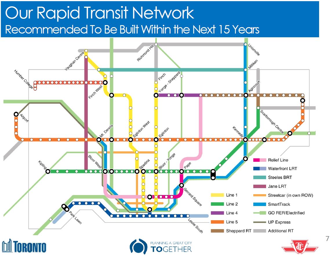
The TTC’s Andy Byford recently committed to a major reduction in subway delays by 2019 thanks in large measure to the introduction of a new signal system on Line 1 Yonge-University-Spadina.

Can this level of reduction actually be achieved? To get a sense of this, we must look at the actual delay reports from the TTC to see the location and type of service interruption. If a problem only account for one quarter of all delays, then a three-quarter reduction in delays cannot possibly be achieved simply by eliminating this class of problem. Similarly, if half of the delays are on one line, and a new technology is implemented on another, then nothing has been done to address delays on the untouched part of the system.

The TTC reports overall reliability statistics in the CEO’s report, but these are (a) not subdivided by cause and (b) use a measure of service “reliability” that would give a perfect score even if a large proportion of the service were missing. As long as trains are close enough to each other, even if there is one gap leading the pack or all of the trains crawl along the line, they do not count against the metric the TTC used for years to report service quality.

The counts below were calculated by reviewing all of the TTC eAlerts for service interruptions on the four rapid transit lines for January 2016. Anyone who reads these alerts and rides the system regularly knows that some delays never make it to an alert, but this is the best we have for published information.

Type of Delay                    Line 1    Line 2    Line 3    Line 4

Passenger Alarm                   6  16%   14  23%    2  18%
Signals                          11  30%   11  18%              3  60%
Mechanical                        1   3%    4   7%    8  73%    1  20%
Track                                       3   5%
Switching                                   1   2%
Security                          5  14%    6  10%              1  20%
Police Investigation              3   8%    4   7%
Fire Investigation                3   8%    8  13%    1   9%
Medical                           3   8%    4   7%
Power Off                         4  11%    3   5%
Unauthorized at Track Level                 1   2%
Late Clearing Work Zone           1   3%    1   2%
Unspecified                       0         1   2%

Total                            37        61        11         5

The details of the incidents are in the following table.

201601_SubwayDelayStats

This is only a one month sample, and there are bound to be somewhat different numbers for other periods, but this gives the flavour of the situation.

Signal problems, annoying though they may be, account for only 30% of the delay incidents on the Yonge line, and 18% on the Bloor line for January 2016. That said, these tend to be the most long-lasting incidents and so their effect is greatly out of proportion to their number. Moreover, the incident count is higher on the Bloor-Danforth line by a wide margin. The new signals on Yonge-University will certainly improve conditions on that route, but delays overall will not be a thing of the past.

If the TTC is going to shoot for improvements, then they must start reporting their delay statistics at a more granular level so the a link will be visible between the type of “fix” undertaken and the location and type of delay whose stats go up or down. This would be a much more useful measure both of service quality and of the effects of management programs to improve the quality of transit service.

GO Transit Electrification Study Public Meetings

Metrolinx has announced a series of meetings for public participation in the TPAP (streamlined Environmental Assessment for Transit Projects) for their GO Rail Network Electrification Study.

Four of these overlap with sessions previously announced by City Planning for other projects under review:

  • Tuesday February 16: John Vanier school in Scarborough
  • Wednesday February 24: Metro Toronto Convention Centre in downtown Toronto
  • Wednesday March 9: Lakeshore Collegiate in Etobicoke
  • Tuesday March 22: Nelson Mandela Park school in Toronto

The area of this study covers only the trackage already owned by Ontario through Metrolinx.

Relief Line, SmartTrack, GO/RER, Scarborough Subway Consultations

Toronto City Planning has released a draft list of upcoming public consultations on various transit plans including:

  • The Relief Line
  • The Scarborough Transit Plan (Subway, SmartTrack, Crosstown East LRT)
  • The Western SmartTrack Plan (SmartTrack, Crosstown West LRT)

2016_ConsultationCalendar

Additional meetings and information about Metrolinx plans (GO Regional Express Rail) will be organized by that agency.

Even more information will be available in March 2016 when the City releases a compendium report on all transit initiatives currently under study. These will include items listed above as well as the “Waterfront Reset” study, TTC Fare Integration proposals and a review of how (or if) Tax Increment Financing can contribute to the many transit projects under review. The intent is that this report will form the basis for public consultation and debate leading to recommendations at Council in June 2016. This is a very aggressive schedule, and there is no indication how consensus will actually be achieved in so short a time, especially with the usually-secretive Metrolinx as an essential player. At least the discussion will be at a network level, not ward-by-ward with a “relief” line for every member of Council, and there will be some filtering of various schemes based on engineering and operational realities.

What is sadly missing from all of this is a discussion of day-to-day transit operations and the backlog in the state-of-good-repair budget. We can blithely discuss billions worth of subway building to Scarborough and a Relief line, but Council won’t fund the basics of running a transit system.