Debates on the effect of Metrolinx service expansions often turn on noise and vibration effects, the degree to which any new or modified service will change the communities through which lines pass. Nowhere is this more striking than in Toronto’s Riverside district where an existing three-track GO corridor will be widened with a fourth GO track plus two Ontario Line tracks.
Reviews of the effects along the GO and OL corridor are hundreds of pages long for those who have the stamina to dig through appendices in so-called environmental reviews, but the material is inconsistently presented. Three separate projects affect this corridor, but no study considers the combination of three services.
This is a major oversight, and it hobbles any public consultation. Metrolinx appears either unable to answer valid questions about the effects of new services, or worse unwilling to reveal information that they should already have. Past experience makes communities distrust what Metrolinx says especially if “consultation” sounds more like cheerleading for decisions made long ago by sage transit wizards.
Updated 4:15 pm: Due to an error in a spreadsheet, the summary counts are off a bit because existing service was included in future totals. This has been fixed.
May 11, 2021, brought a shower of money, or at least promises of money, onto plans for rapid transit in Toronto. The federal government announced a total of $10.7 billion to fund a 40 per cent share in the Ontario, Scarborough, Yonge North and Eglinton West projects.
May 12 brought another, albeit smaller, promise of $180 million each from the federal and provincial governments to fund expansion of the streetcar fleet on which Toronto already planned to spend $208 million.
On May 13, a funding announcement for the Hamilton LRT line is expected. This is a project the province had tried to kill.
Combined with their recently announced national transit funding program, the federal Liberals are making a real splash in the transit pond, at least for big-ticket capital projects.
Before we all head out for a socially distanced beer or champagne celebration, there are important caveats.
Why 40 Per Cent Isn’t Necessarily 40 Per Cent
When the federal government agrees to fund a project, the dollar value is (or more accurately will be) “as spent” dollars without any provision for inflation. If Queen’s Park says that the Ontario Line is going to cost $10.9 billion, that’s what the 40 per cent is calculated on. Add-ons or inflation will be entirely on Ontario’s dime, unless a future federal government takes pity.
The last time a subway project ran out of money due to a hard cap on the “commitment” was with the Sheppard Subway’s terminus at Don Mills. Ironically, it was a conservative provincial Premier, Mike Harris, who capped spending on that project, and Toronto did not have enough money to continue east to Victoria Park, much less beyond to Scarborough Town Centre.
Cost overruns on the Vaughan subway extension were shared by Toronto and York Region.
The announced costs for the four Ontario key projects in Toronto are:
Ontario Line: $10.9 billion
Yonge North: $5.6 billion
Scarborough: $5.5 billion
Eglinton West: $4.7 billion
Total: $26.8 billion
“The federal government is contributing 40% of each project, up to a total of $10.4 billion” according to Infrastructure Canada’s announcement. This could give leeway for allocations to move between projects, but sets a total on the group.
This puts all four projects in a box, and will make adding costs to them very difficult because there will be no matching federal dollars. The dubious nature of the spending, notably on the Eglinton West underground alignment, appears to be of little concern to the feds who do not want to be seen as interfering in local decisions.
That stance takes an odd turn when we see that there are conditions on this support, although I suspect that many are window dressing.
The federal government understands that every taxpayer dollar invested in public transit must have multiple benefits including creating good jobs, building more equitable and inclusive communities, and tackling climate change. That is why the federal government’s funding is dependent on satisfying conditions including demonstrating how the investments will drive down emissions and build resilience, substantive environmental reviews, ensuring affordable housing along the line, incorporating accessibility, mitigating local concerns, maximizing benefits for communities including through Community Benefit Agreements, and meeting employment thresholds for underrepresented communities including Black, Indigenous and people of colour, and women.
Just what is meant by “substantive environmental reviews” and “mitigating local concerns” is anyone’s guess especially in light of Canada’s rejection [22 MB PDF] of a requested environmental review of the Ontario Line. In brief, the feds hold that there are provincial and municipal processes in place to address concerns, and moreover that there are few areas of federal jurisdiction touched by the Ontario Line.
Metrolinx projects already provide accessibility and include Community Benefit Agreements. These “requirements” simply reinforce what they are already doing.
The Ontario Line is under fire in at least two locations, Riverside and Thorncliffe Park, because of intrusions on the community. In Riverside, the debate is over underground vs at grade construction, as well as the proposed alignment, and Metrolinx’ possible misrepresentation of the combined GO Transit and Ontario Line corridor from the Don River to Gerrard. In Thorncliffe Park, the proposed maintenance yard requires the expropriation of a group of offices and shops that form a community centre. A Mosque is also affected, although it plans to move to another building nearby.
Changing the design in either of these areas will almost certainly raise costs, and the project cap will be used to counter any such proposals. Oddly enough, this was not an issue on Eglinton West which is going undergound at a cost of nearly $2 billion so that the good people of Etobicoke do not have to see streetcars in their neighbourhood. That decision is now baked into the project cost, and Metrolinx is on the verge of awarding the tunneling contract.
The planned alignment of the Yonge North extension under the Royal Orchard neighbourhood is also under fire, although Metrolinx claims that the line will be so deep it will have no effect on the residential community above. That is an intriguing claim given that the tunnel portal is in the GO rail corridor and the trains will not leap instantly from deep underground to the surface.
The Scarborough decision has long been a fait accompli, but the current announcement commits the feds to a 40 per cent share of the expanded project.
More Streetcars for Toronto
In 2020, the TTC proposed that the streetcar fleet be expanded by 60 cars, and the City signed on to fund 13 of these. The remaining 47 are now funded by contributions from the other governments, a move that will keep Thunder Bay happy with a vehicle order to keep the now-Alstom (formerly Bombardier) plant going. Some work will also go to the Alstom plant in La Pocatière, Québec.
The subway extensions will also need new cars, but unlike the streetcar fleet, there is no open contract to simply be extended. It will be interesting to see how additional cars for Line 1 and a new fleet for Line 2 will be tendered, and what political machinations will bear on the vendor selection.
The expanded streetcar fleet will not all fit in existing facilities at Leslie, Russell and Roncesvalles. The TTC plans to renovate Harvey shops at Hillcrest as a small carhouse serving (at least) the 512 St. Clair route. The existing streetcar maintenance facilities at Hillcrest were designed in the 1920s for standard sized streetcars and could only host a few Flexitys at a time during the early testing and acceptance period.
Now that the full order for more cars has funding, the Hillcrest renovations can proceed.
Left at the Altar
Important projects which might benefit from federal funding are still sitting in limbo including:
Eglinton East LRT to UTSC and Malvern
Waterfront East LRT to Broadview
Line 2 Bloor-Danforth Automatic Train Control and fleet renewal
New Line 2 maintenance facility west of Kipling Station (Obico yard property)
There is a separate federal program to fund transit, but that is already partly earmarked for electrification of the bus fleet and garage upgrades. How much will be left for other projects remains to be seen.
With all of this new money for Toronto transit, the TTC needs to update its Capital Plan to reflect the current status of project funding and the remaining budget shortfall. We might have billions worth of promises, and even a few celebratory bottles to drink, but there is a long way to go thanks to decades of deferred investment.
Metrolinx held one of their online consultations on April 22. This time the subject of the Ontario Line between the Don River and Gerrard Street. Normally, I would not review meetings like this in detail. However, I had proposed an alternative alignment and have worked with community groups on this. A reply to statements made by Metrolinx at the meeting is, sadly, essential because of the misdirection and misinformation in their presentation.
The presentation deck for the meeting is available online as is the video of the session on the event page. I will not rehash all of this material and leave these to interested readers.
It was quite clear that Metrolinx thought that they had a presentation to answer the community’s questions, and they launched into it in their usual confident style. However, as the session progressed, and especially during the question-and-answer period (which require a meeting extension to fit everything in), things started to come unglued.
A common tactic would be for Metrolinx to reply to a question with either a partial response, or with a discussion of an issue that had not been asked. I could be generous and assume that they just didn’t hear the question properly, but this happens too often to be pure chance (or mere incompetence). This suggests a deliberate misrepresentation of questions by providing an answer to something that was not asked.
Many questions were submitted in advance on the event page, and these were bundled by the moderator for Metrolinx’ answers. I have consolidated responses from different parts of the session to group related comments together.
Readers of previous articles will be pleased to see that Metrolinx has produced a map with North at the top where it belongs.
The original hoopla about this portion of the Ontario Line included the alleged virtues of the “straddle” design with OL tracks bracketing the GO tracks to allow cross-platform transfers at East Harbour. Metrolinx has now discovered that this brought extra cost and design disadvantages, and they now tout the side-by-side alignment’s benefits. Metrolinx plans are immutable, at least until they embrace a better idea.
When I first wrote about this project and its effects, Metrolinx advised that they would not be releasing information about the site selection until late 2022, roughly the same point where a contract for construction would be awarded and long after any design changes would be possible.
This position changed quite recently, and the presentation deck for a public meeting on April 15 includes maps of the proposed sites. The original version included the legend “Elected Officials Only” is part of these illustrations and shows how this deck was closely held until quite recently. A revised version posted during the meeting has some differences in the deck.
Although sites downtown and west to the Exhibition were considered, none of them was large enough to accommodate the MSF and yard.
A common thread through this process is that all of the facilities will be at one location as opposed to building storage at various points along the route. That approach would take advantage of train automation to allow remote dispatching of trains to and from service, but it has not been included in the design.
Most of the sites are clustered around the Ontario Line corridor with a few exceptions well away from the line. These are described in the maps below.
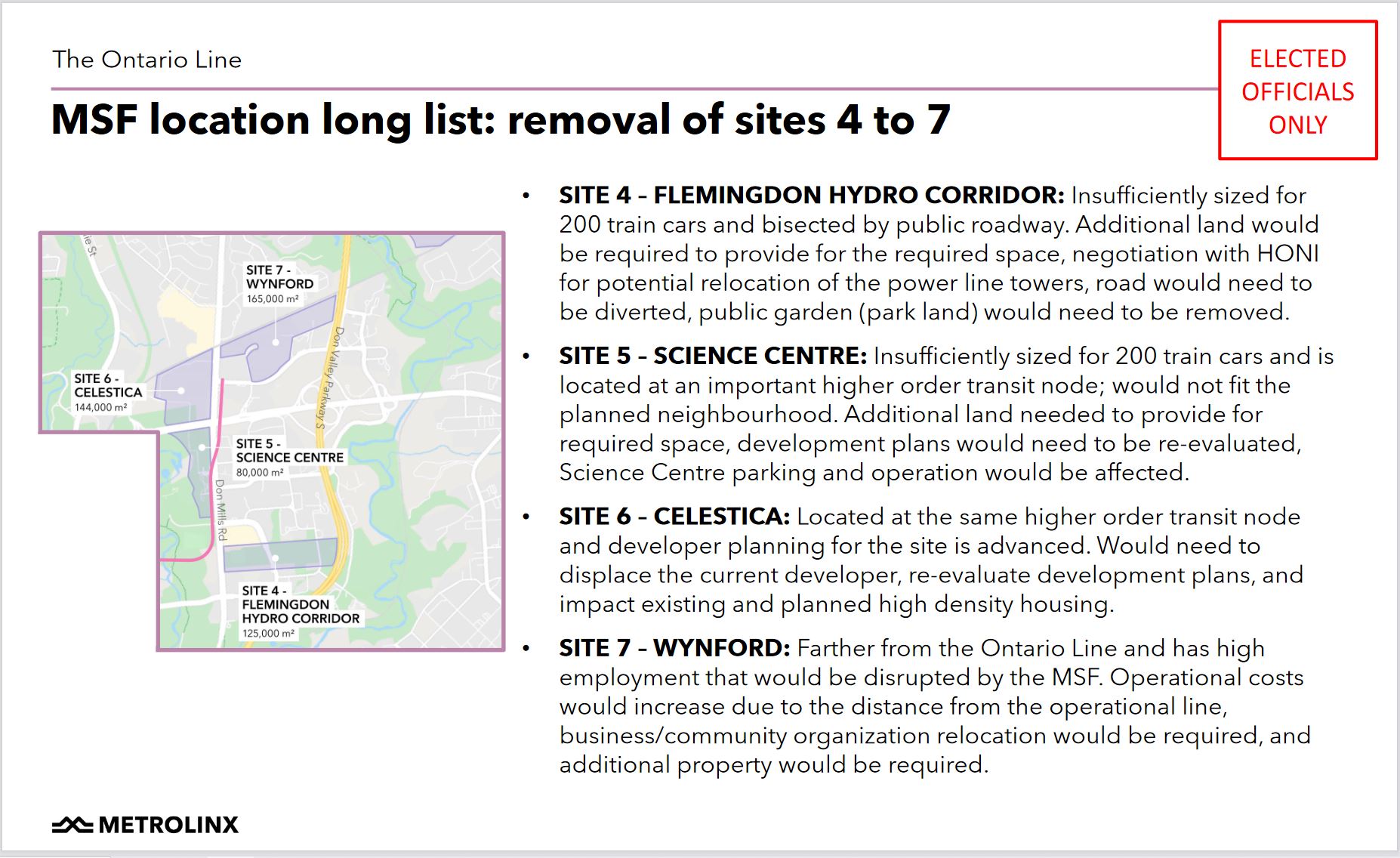
The slides describing the removal of various sites from consideration were in the originally posted version of the deck, but they do not appear in the version now online and shown at the meeting.
Four sites in various parts of Flemingdon Park were rejected either because they are too small, they are too far from the main line, or because major development is already planned on the site.
In the original Relief Line Subway plan, trains would have been stored and serviced at Greenwood Yard. This yard is too small for the projected Ontario Line fleet, an intriguing claim considering the relative demand and capacity on Line 2 (now served mainly from Greenwood) and the future Ontario Line.
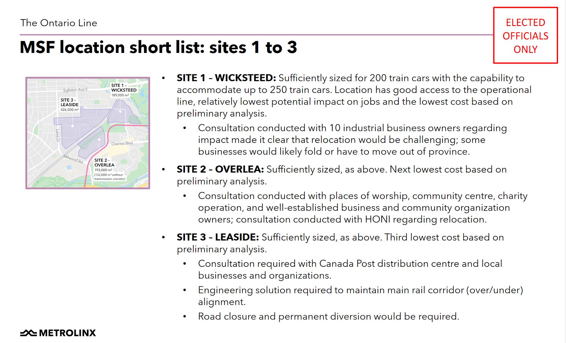
This leaves three sites on either side of the CP rail corridor through Leaside. Each of these sites has its challenges.
Metrolinx settled on using parts of site 1 (the southern part of the Wicksteed block), and site 2 (the northern part of the Overlea block).
In the previous article comments thread, a reader suggested placing the storage yard in Site 3 (the northeastern portion of the Leaside block). This requires an underpass at the CPR. It is not clear whether Metrolinx considered a hybrid Site 1-3 scheme that would not require the entire Leaside block, only enough room for the storage yard now planned for the northern portion of Site 2.
In the public meeting, Metrolinx stressed that they would be talking to affected businesses about support for relocation. The surprise expressed at this plan by members of the community suggests that consultation is comparatively recent although planning has been underway for some time.
The affected properties are shown in the map below.
The Islamic Society of Toronto plans to the move the Masjid Darussalam mosque from 4 Thorncliffe Park Drive to 20 Overlea Boulevard according to Metrolinx.
Metrolinx said that they are “keenly aware” of impacts to businesses and importance of Iqbal Foods (located in 2 Thorncliffe Park Drive) in the community. They are dedicated to work with all of the business owners to relocate “within the neighbourhood”. How much financial help will be involved remains to be seen. CEO Phil Verster said that it is “100% our intent” that these businesses are not lost to the local community.
Metrolinx received many complaints about timing of their announcement and holding the meeting during Ramadan in an area with a large Muslim population. They plan to hold more consultations after the holy month concludes in mid-May.
The overall project timeline for the North Section of the Ontario Line is summarized in the chart below.
The map of the northern segment of the Ontario Line published by Metrolinx in their October 2020 blog article has been added for reference. Scroll down to the end of the article.
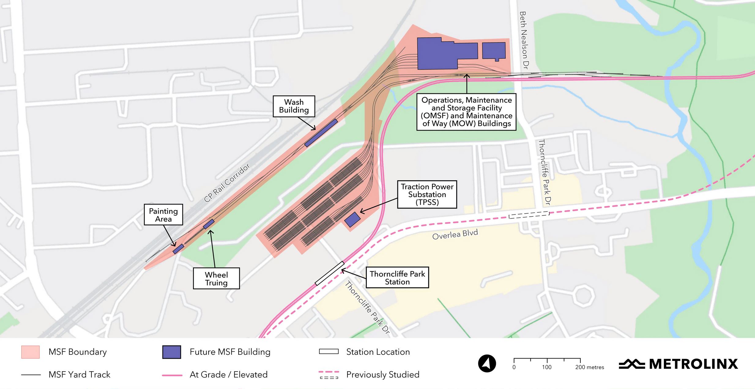
Metrolinx has unveiled a plan for the Ontario Line’s Maintenance and Storage Facility north of Thorncliffe Park. Because of the local terrain, green space and the Hydro corridor (not shown on the map below), this is split into three distinct sections:
The main buildings are west of Beth Nealson Drive north of the Don River.
Some servicing areas are in a long spur parallel to the CPR corridor. This will also be the location of a delivery track where vehicles will arrive from the manufacturer.
The storage yard will be in an area now occupied by various shops and offices as well as a mosque.
Here is a satellite view from Google Maps rotated to match the orientation of the map above.
Source: Google Maps
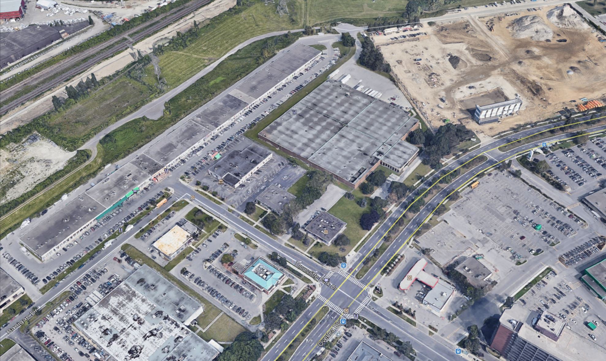
The area to be occupied by the yard at the north end of Thorncliffe Park Drive West is shown below. This was taken before the Costco building went up on the vacant land in the upper right of the photo. The Ontario line will run north from Overlea Boulevard along the west edge of this property.
The area for the main buildings on Beth Nealson Drive is shown below as it currently exists.
Source: Google Earth
According to the Metrolinx Blog article on this plan, the site was chosen from a list of nine. Metrolinx has not published the other locations that were considered.
The work we did to identify the best site for the MSF and yard will be pulled together as part of the Environmental Impact Assessment Report that will be available in 2022.
We can let you know we looked at land near the western terminus at Exhibition all the way to the east and to the northern end of the alignment. A list of nine sites were brought forward for more detailed analysis, some of which were ruled out because they weren’t big enough or they affected too many businesses and jobs.
The site in the southeast portion of the Leaside Business Park was selected because our studies showed that it keeps impacts to the local community to a minimum while meeting all of the needs for the project:
• it is already zoned for industrial use;
• it is close to the main line, making it quick and easy for trains to go in and out of service;
• it is large enough to meet future needs;
• it minimizes community impacts;
• has less individual job impacts.
Email from Metrolinx Media Relations, April 9, 2021
While the northern portion that will house the main buildings might only displace a self-storage farm, the southern portion where the yard will be located sits on top of buildings that are an integral part of the Thorncliffe Park community. What the reaction will be might be gauged at an online meeting to be held on April 15, 2021 at 6:30 pm.
Updated April 12, 2021 at 9:30 pm:
When Metrolinx announced their revised route through Thorncliffe Park in October 2020, they touted the fact that this would avoid disruption of buildings such as the Macedonian Orthodox Cathedral. The map of the revised route is below.
Note the area labelled “MSF Study Area”. This is the location, in the updated plan, for the Operation and Maintenance building. The area at the north end of Thorncliffe Park Drive West is not touched by the line and there would be no reason for anyone to raise flags about the businesses and institutions already there.
The yard which is now part of the complex is completely new, and there was no advance indication that this would be part of the design.
On a related note, one of the comments below from Simon Hirst suggests that an alternate location might be the land on the other side of the CPR corridor now occupied by a gravel and cement company. This is visible as a white patch directly above the “MSF Study Area” in the Metrolinx map above (where “north” is to the right, and “west” is up), and in the view below which is a closer view of the same area in the usual geographic orientation.
Source: Google Maps
If that area were to be used, a connection tunnel would have to go under the CPR to link with the Ontario Line whose main shops and offices would be where the brown-roofed buildings labelled “Toronto Moving and Storage” are in the upper right of the photo.
Because Metrolinx has not published its list of alternative sites, we do not know whether this option was considered but rejected for some reason.
Metrolinx does not plan to publish its alternative site analysis until Fall 2022 with the Environmental Project Report, but they also intend to let the contract the includes construction of the MSF and yard at roughly the same time precluding major changes in design.
Infrastructure Ontario issues quarterly updates about the projects it is managing for P3 procurement, and I have been tracking the transportation items on this site. Their April 2021 Market Update came out on April 8, but I have been waiting for clarification of some issues before posting here.
Here is a spreadsheet tracking changes in project status since these updates began.
Items highlighted in yellow have changed since the last update.
Note that this report only covers the procurement portions of Metrolinx projects that are undertaken through Infrastructure Ontario. Contracts that are in construction, or are directly tendered and managed through Metrolinx outside of the P3 model, do not appear here.
Ontario Line, Line 1 North Extension (Richmond Hill Subway), Line 4 Sheppard East Subway
There are no changes to these projects in this update.
Line 2 East Extension (Scarborough Subway)
As previously announced, the tunneling contract gets underway this spring. The contract for the remainder of the project (stations etc.) enters the Request for Qualifications (RFQ) stage this spring/summer, but contract execution is not expected until spring 2023.
Note that vehicles for the extension will be procured as part of a TTC order for fleet expansion and renewal that does not show up in the IO updates.
Line 5 Eglinton West Extension
As previously announced, the tunneling contract gets underway this spring. There is no date yet for the remainder of the project to enter the RFQ stage.
GO Expansion Projects
Metrolinx came up with a new term for procurement, the “alliance” model where more responsibility for the project is shifted back onto Metrolinx as owner rather than expecting bidders to take on a substantial project risk. This showed up in the Union Station platform expansion project early in 2020.
In this round of updates, things appear to have gone a step further. Three projects (Lake Shore East and West Corridors, and the Milton Corridor) are reduced in dollar value. I asked Infrastructure Ontario about this, and they replied:
Since the previous Market Update (Dec 2020), there have been some changes in scope of work for these projects. Items which have been descoped may be carried out by Metrolinx in the future under separate, traditionally-procured contracts. The intent is to better manage risks and costs with respect to the GO Expansion program.
As these projects remain in procurement, we will provide further updates this spring/summer.
Email from Ian McConachie, IO Media Relations, April 9, 2021
Specific changes by corridor:
Corridor
Change (per Infrastructure Ontario)
Previous Cost
Updated Cost
Lakeshore West
Descoping of Exhibition Station in-corridor enhancement works and track improvements, Clarkson Station and Bronte Station in-corridor enhancement works.
$500M-$1B
$200-500M
Lakeshore East-Central
Descoping of Scarboro Golf Club Works and 2.5km of grading (previously part of LSE-E) and deferral of Highland Creek Expansion
$200-499M
$100-200M
Milton
Descoping of Station Operations West Facility and replacing the pedestrian tunnel with a pedestrian bridge.
$100-199M
< $100M
The project formerly called “Milton Corridor” is now called “Milton Station”.
A separate project line, Lakeshore East-West Corridor, dropped off of the IO Update in mid-2020. The project was transferred to Metrolinx for delivery as a non-P3 contract.
The comment about “better manage risks and costs” is telling here, and it implies that the P3 model has not worked out as favourably as hoped for all of Metrolinx’ work. In some cases it is simpler and cheaper to just go out and buy/build something yourself than to set up elaborate machinery for others to do this for you.
Notably the $10B GO “ON-Corr” project which entails a complete restructuring of GO including future operation, maintenance and electrification has not changed status in a year. With GO’s ridership uncertain in the near term, projecting just what Metrolinx might ask a P3 to undertake, let alone contracting for it, is like peering into a very cloudy crystal ball.
This article is a follow-up to Ontario Line Design Changes Again including material from a new Metrolinx blog post.
As previously reported, Metrolinx has changed the track configuration between Corktown and Gerrard Stations on the Ontario Line so that both OL tracks are on the same side (north/west) of the rail corridor rather than straddling the four-track GO corridor.
When the Ontario Line was announced with much fanfare, a great deal was made by Metrolinx of the across-the-platform transfer connections possible at both Exhibition and East Harbour Stations with the GO Lakeshore corridor. The explicit benefit was to offload of GO/TTC transfer traffic from Union Station.
This design fell off the table (quietly) last year at Exhibition Station, but until quite recently, it was still advanced as the rationale for the OL’s configuration in this segment.
Now it too has disappeared and both OL tracks will be on the same side of the corridor. This actually makes life easier for Metrolinx designers including:
only one shared centre platform rather than two would be needed at stations, and only one set of vertical accesses (stairs, escalators, elevators);
electrification of GO will be relatively isolated from that for the OL which will run on a different voltage and probably a different height of overhead above the rails;
only one bridge rather than two will be required to carry the OL across the Don River;
only one tunnel portal will be required at Gerrard rather than two;
no tunnels under the rail corridor will be required to shift the eastbound OL first to the south side at East Harbour and then back to the north side at Gerrard;
there is room at East Harbour for platforms for all four GO tracks, not just the two outer ones, permitting this to be an express and local station as befits its location at a major development node.
Considering that Metrolinx is all about building projects more efficiently, one has to wonder why they didn’t pursue this configuration from the outset unless that cross-platform transfer was a holy grail untouchable until now.
The change is promoted as the result of listening to the community where more than a little opposition to the OL came from its intrusiveness and potential effect on buildings and open spaces. Until quite recently, Metrolinx defended their original design against all criticism.
Their tune has changed:
Re-positioning Ontario Line tracks at East Harbour means all Lakeshore East and Stouffville GO train services can stop at the station – something that wasn’t possible with the previous design. With a shared concourse providing easy access to all of the rail services that will serve East Harbour, more customers will be able to transfer between more trains, and travel to more places.
Customers who will be boarding the stations at Queen and De Grassi and at Gerrard and Carlaw will also see more benefits because, no matter what entrance they use, they’ll arrive at a centre platform that serves trains in both directions. They won’t have to worry about getting to platform level just to realize their train is on the other side of the rail corridor, accessed through a different station building. This will create a simpler, more accessible experience for everyone who uses the station.
[…]
But the improvements to the track positioning means teams can cut down on the amount of station buildings needed as well, which means even fewer impacts to the parks that have been developed around the active rail corridor over the years.
The line now occupies slightly less space than before, although the diagrams above are not engineering drawings showing the exact scope of work before and after the redesign.
Metrolinx is still silent on the need for or absence of crash walls between the GO rails, the Ontario Line and nearby buildings. These would add to the total width of the corridor.
Metrolinx would do well to show more detail for their new plan all the way from the Don River to the portal(s) at Gerrard.
Another round of community consultation is planned in coming weeks.
I reviewed the first report in The Siren Song of Regional Fare Integration and will not duplicate my comments on the Board of Trade’s fare proposals beyond the level needed to explain how the scheme in Getting on the Right Track dovetails with this.
From the title of the article, one can easily guess that I was not entranced with the Board’s proposal, and I should make clear why right at the outset.
First: Although the plan includes a very robust regional network with frequent service on all GO corridors, there is too much talk of how everything will work when it is finished, and not enough about how we actually get from here to there.
Second: As with so much regional planning that comes out of Metrolinx, there is no discussion of last mile costs and service, nor of the burden local municipalities would face in providing them. Yes, a “last mile” report is in the offing, but this could range anywhere from massive increases in publicly funded local transit to an embrace of ride sharing services. The report contains not even a hint of how the vastly improved service will get riders to and from its stations.
Third: The focus is very strongly on Toronto (the 416) where there is an established transit system that can provide frequent service at connection points, but less on how this would scale outward into the 905 and beyond.
Fourth: The Invisible Line report and its fare-by-distance proposal is assumed as a pre-requisite even though there is no agreement that this is how fares should and will be calculated. In particular, its gerrymandering of fare zone boundaries and the tariff has not been subject to critical review outside of venues such as this blog.
Many proposals in Getting on the Right Track are good and provide a level of background we have not seen from the nominal regional planner Metrolinx, an agency that prefers to save proposals for Ministerial photo ops and routinely hides details under confidentiality provisions.
To give Metrolinx their due, a key shortcoming in the Board of Trade’s report is that it does not clarify which parts of its proposal are works already in the Metrolinx pipeline, and which are net additions to the scheme. Indeed, maps purporting to show regional networks and travel times do not even acknowledge rapid transit lines planned and under construction that will open within the timeframe of the Board’s proposal.
An untutored reader might think that almost nothing is underway, that the Board has returned from the mountaintop with the one true word on regional transit.
Finally, and particularly toward the end of the report, elements creep in which feel like pet rail projects with only minimal evaluation. They are included either because the Board sought to curry favour with politicians in the affected areas, or because someone had too many crayons to play with. I leave it to the dedicated reader to peruse those parts of the report.
There is a sense throughout that what might have been a reasonable proposal for Metrolinx to aim higher in its plans evolved into a design exercise that substitutes detail and volume for practicality.
“Organization Before Technology Before Concrete”
On page 20, the Board makes a key observation, if only by implication, about how transit is planned in the GTHA by citing a practice elsewhere:
The German-speaking world has propounded the planning and engineering doctrine of “organization before technology before concrete.” The highest priority is to resolve issues of organization, which includes factors like fare and service integration between agencies. Then, technology, such as better signalling systems and rolling stock, should be improved. The last priority is the building of new infrastructure, like additional tracks and grade separations on corridors. This prioritization provides the most economically efficient means of improving service and capacity on a network.
Getting on the Right Track, p. 20
This is one of several cases where there is an implicit, if not explicit observation that the way “we” do business is out of step with good practices elsewhere, or even just common sense here. However, the Board has violated its own principle by driving through an entire network design exercise without clearly figuring out goals, not to mention the basic question of how much we might be prepared to spend on this transit network.
“We” is a tricky term here because there are three levels of government each of which prefers to fund only certain types of service and infrastructure, and each has significant blind spots in the financing and funding of public transit.
In this article, I will not attempt an exhaustive review because even my readers have limits to their patience. Moreover, there are points where one must peer very deeply into the crystal ball, make too many assumptions about actual future circumstances. If our current situation teaches anything, it is that the future will change.
Guiding Principles
This section is buried down on page 21, and yet it is absolutely key to the entire discussion. It is so important that I will include its text here.
Drawing from international best practices, it is possible to demonstrate five guiding principles that form part of successful implementations of regional rail. Based on these principles, it is possible to design a network and operations plan for the Toronto Region.
Two-way, All-day Service
The majority of trips in any region – even work trips – do not involve the downtown core and do not take place at rush hour. A service plan that provides service all day, every day is essential if a regional rail system is to become a core part of the regional transit network.
High Frequency (turn up and go)
Research by Transport for London indicates that riders on routes with a frequency of 12 minutes or less will not need to consult a schedule and can instead simply “turn up and go.”
This level of service has been demonstrated to drive major increases in ridership. Frequency is even more important when making connections because wait times can multiply when a trip involves several connecting segments, and a missed connection could result in an unacceptable delay.
Seamless Integration with Local Transit
On a busy commuter rail service like GO Transit, park-and-ride lots fill up early in the morning. That makes them effectively useless for mid-day travellers. For two-way, all-day service, there needs to be another way to access the station. Transit-oriented development can play a role – and provides a major opportunity for recovery of regional rail investment – but as the TTC subway demonstrates, the most effective way to deliver large numbers of riders is by seamlessly integrating rail with local bus and streetcar services. That means fully integrated fares – a transfer is an inconvenience, so you should not have to pay more for it. It also means having bus routes designed to connect with stations, additional rail stations to connect with busy surface corridors, and schedules with timed transfers where necessary. The objective is to create the equivalent of a subway backbone for the whole region, serving local trips as much as long-haul. By being a backbone of a broader transit network, regional rail does not just serve residents of neighbourhoods adjacent to stations – it serves everyone in the region.
Focus on Equity
Planning should intend to prioritize improved access to employment opportunities and services for equity-seeking communities. This means reducing travel times, locating additional stations where they would serve communities like the City of Toronto’s Neighbourhood Improvement Areas, and ensuring that fares are not prohibitively expensive. Transit must function as an integrated network, particularly for those who rely on it for all their trips so it is imperative that no transit mode be deemed “premium.”
Integration with Regional Planning
With its region-wide extent and high level of service, regional rail should become a centrepiece of regional planning. In Copenhagen, for example, all substantial office developments must be located within walking distance of a rail station. This would not be possible today in Toronto, given the limited size of the existing rapid transit network, but it could be possible with regional rail. Greenfield suburban developments could be designed around rail stations, creating “15-minute communities” oriented to walking and cycling, rather than following the traditional auto-oriented pattern centred on concession road blocks. Regional rail is the most feasible path to a truly transit-oriented region.
These are key principles not just for a regional rail network, but for transit in general. They run counter to so much of what would-be transit riders are fobbed off with.
“High frequency” really does mean frequent service, not a train now and then when it is convenient to run one. This requires a commitment to both capital and operating costs for the rail network.
“Seamless integration” means an end to assuming that parking will solve all access problems, and that the rail system’s revenue stream is sacrosanct. The concept of a “premium” service as a justification to charge higher fares on part of the network simply does not work if the rail lines are the key, backbone component of a whole. This is an example of how looking at only one aspect – fare revenue – distracts from the larger picture of the potential contribution and value of the rail network for mobility.
As for regional rail and planning, this is a fascinating position for the Board of Trade because it implies that we would dictate where development could and could not occur. Will we also consider network effects of overbuilding at selected “hot” development nodes, and the implications for road congestion and pollution of allowing growth away from transit stations?
The Trillium Network
Yes, it’s a branding exercise, and the Board makes no bones about this. It has a nice sound, and it uses the provincial flower. The name and logo might even survive a change of government. There is a spiffy map.
The key point in this design is that services are through-routed at Union Station and arranged in a manner to avoid conflict between four main corridors: Lake Shore, Kitchener-Don-Richmond Hill, Barrie-Don and Milton-Lincolnville. This is not new, and Metrolinx has talked about the need to reorganize its service in a similar way as part of its expansion program.
Services have route numbers all starting with “T” although the nomenclature could be confusing if a scheduler decides that trains will operate between some other pair of endpoints. The combined service through Union Station is impressive with the intent of a massive increase both in GO’s capacity and its usefulness as a regional and local carrier.
This post is a departure from my usual reportage and takes us into the realm of “what would you do” advocacy.
The ongoing debate about Metrolinx’ proposed above ground route for the Ontario Line between East Harbour and Gerrard Stations turns on two issues:
The effect of a six-track wide shared GO+OL corridor on the neighbourhoods through which it will pass.
Whether the Ontario Line could be tunnelled.
The debate was recently clouded by a proposed shift in the OL’s alignment. Originally, the line would straddle the GO corridor in order to provide “across the platform” transfers with the outer two GO tracks at East Harbour. Metrolinx is now contemplating shifting both OL tracks to the north/west side of the corridor. This has several advantages as I discussed in a recent article, but it leaves the OL above ground.
The original configuration is shown below in a map from Metrolinx’ site. Note that North is at the right.
Putting the line underground on this alignment is very difficult because of constraints on the grade change between East Harbour and the (misnamed) Leslieville Station. Any descent is constrained by the cross-streets let alone the vertical difference between an East Harbour Station on the rail embankment and a Leslieville Station at Queen.
A neighbourhood group (The Lakeshore East Community Advisory Committee, aka LSE CAC) posed the question to me: is there a way to put the line underground? On the Metrolinx alignment, the simple answer is “no”, but that brings us to the question: why that alignment?
The original Relief Line would have crossed under the Don River on the line of Eastern Avenue with a station at Broadview as shown in the diagram below. The link with GO at East Harbour would not be as simple or direct as in the Metrolinx proposals where the OL and GO tracks and platforms are adjacent.
Metrolinx seeks to offload GO traffic from Union Station and sees transfers to the OL at East Harbour and Exhibition as a solution. However, changes to the planned layout at both stations have stripped the simple across-the-platform transfer for peak directions from their designs.
At Exhibition, only the westbound service would connect with the south side of the terminal station platform. Inbound (eastbound) GO riders would have to access the OL via an underpass. At East Harbour, if the alignment shifts to the north side of the station, the westbound GO track would be adjacent to the eastbound OL track, and there would be no direct link to the eastbound GO platform.
Metrolinx now describes the connections as more convenient rather than direct, but the attraction of a simple transfer to shift traffic has disappeared.
An alternative scheme, which I developed before Metrolinx plan to shift the OL to the west/north side of the rail corridor, uses the proposed eastbound tunnel under the rail corridor as its starting point. Instead of carrying just the eastbound track, it would house both directions, and they would cross the Don River on a dual track bridge south of GO’s trackage where a single eastbound bridge was proposed by Metrolinx.
A shared platform at East Harbour would be oriented to be as far west as possible and only one OL train length (not the full size of a GO platform). The east end of the platform (and hence the point where a descent underground could begin) is dictated by the proposed Broadview extension which would pass under East Harbour Station.
From that point, the line would turn east and descend through what is now largely vacant land and a laneway behind a heritage buildings on Eastern Avenue.
East of Booth Avenue, the line would swing north and join the original Relief Line alignment east of Logan.
The illustration below was prepared by the LSE CAC based on my proposal.
Courtesy of “Save Jimmy Simpson” / Paul Young
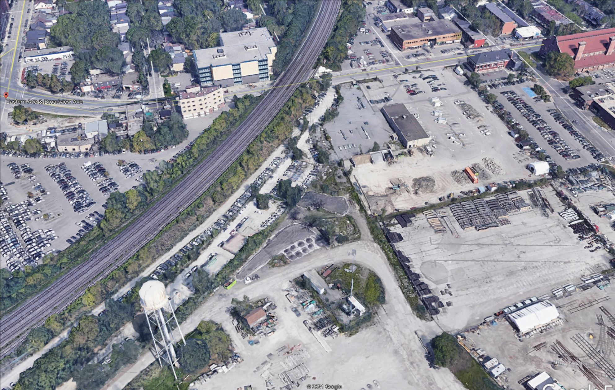
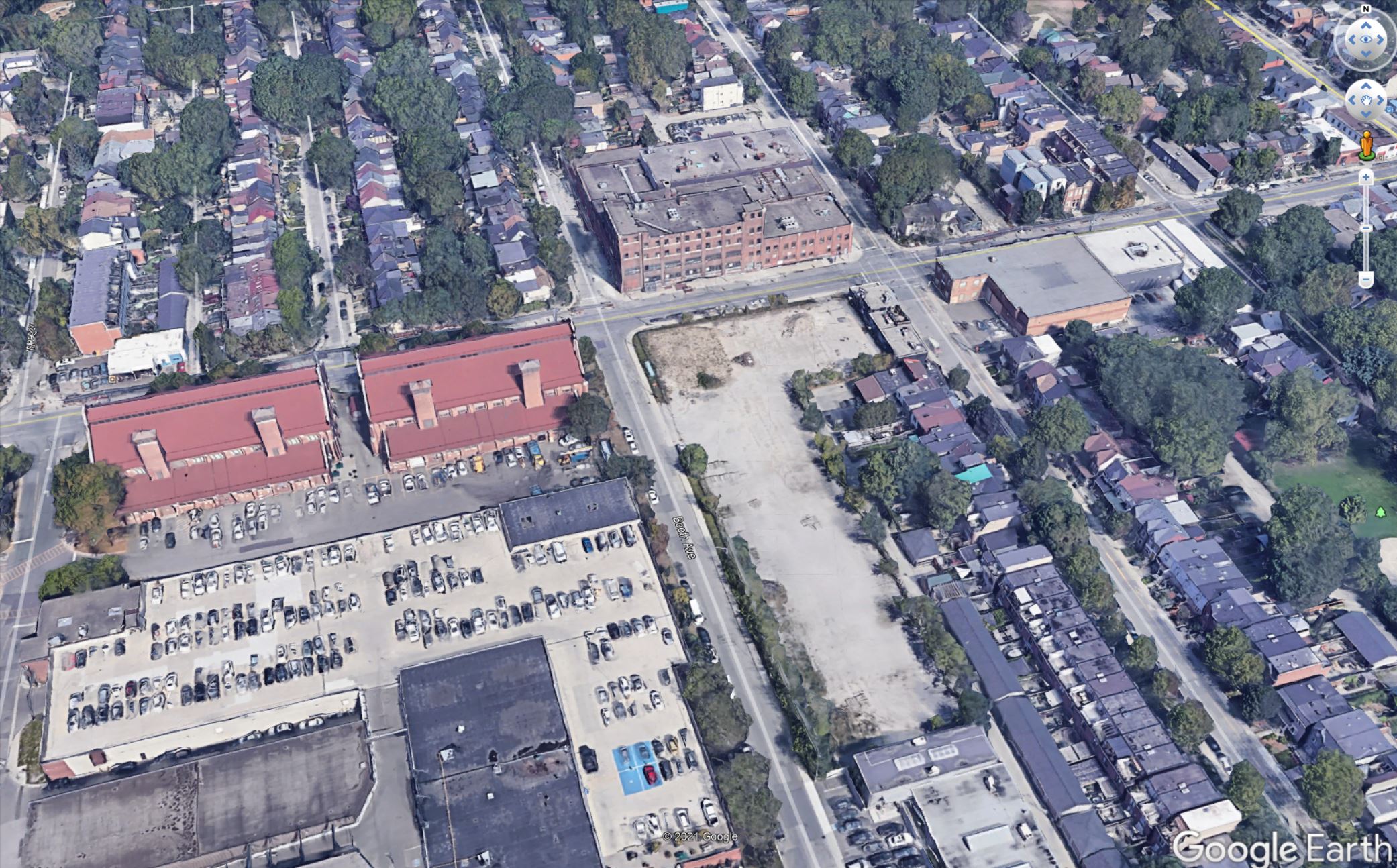
Here is the west end of this area. For reference, the Broadview Extension will cross just west (left) of the water tower (which is to be retained as a landmark in the new development here).
Source: Google Earth
Here is the east end of the area. Note that the vacant lot on the south-east corner at Booth and Eastern in this photo is now occupied by a self-storage building that would have to be removed.
Source: Google Earth
I have no illusions that this would be an easy alignment, but it has advantages over attempting to fit the Metrolinx route under ground:
The transition from above grade to underground would occur in largely vacant land and before the line must cross a major street (Eastern), preferably west of Booth so that this street would remain open.
The Leslieville Station is far enough from East Harbour that it does not constrain the vertical alignment in the same manner as the station would at Queen & Degrassi.
Potential issues include:
The City has plans for this land in the East Harbour development and they would have to be revised to accommodate the ramp and portal structure for the Ontario Line.
The OL structure would be close to the surface continuing its descent to Carlaw. This could affect utilities where the alignment crosses Booth, Eastern and Logan, as well as some properties along the curve between Eastern and Carlaw.
It is self-evident that an underground route from East Harbour to Gerrard will be more expensive than the Metrolinx proposal along the rail corridor.
Very bluntly, I could be more sympathetic to this issue if Metrolinx were not already pursuing underground options in Scarborough and on Eglinton West at great expense for blatantly political reasons.
Updated March 27, 2021: The reference to third rail power pickup for the Ontario Line was incorrect and has been changed. According to the December 2020 Preliminary Design Business Case the line will use 1500V DC overhead power supply.
As originally announced, the Ontario Line was intended to run along the GO Lake Shore East corridor between the Don River and Gerrard Street with the new rapid transit tracks straddling the GO transit line as shown in the map below.
Discussions with the Riverside and Leslieville neighbourhood have been fraught with concerns about the combined effect of the two new Ontario Line tracks, the stations, the expanded four-track GO corridor and the infrastructure needed for electrification. This has been the subject of previous articles and I will not rehash the issues here.
At a community meeting on March 25, 2021, an unexpected piece of news was revealed not by Metrolinx staff, but by City Councillor Paula Fletcher: Metrolinx has changed the design so that the Ontario Line tracks will run on the west side of the GO corridor.
I asked Metrolinx for their comment, and here is their reply:
As part of our planning, we have been exploring alternatives that will allow us to incorporate some of the feedback from the community. The updated plans are not yet final so it is too early to provide details or images.
One thing we are looking at is shifting both Ontario Line tracks to the west side in the corridor, rather than on either side of the GO tracks.
Once finalized, we will be sharing the updated plans related to the configuration with the community in the coming weeks at a public consultation.
We are still conducting environmental assessments for the area, which include a Joint Corridor Early Works Report and an Environmental Impact Assessment Report for the whole line.
Email from Metrolinx Media Relations, March 26, 2021
This has many implications including the total space needed for the six-track corridor, the placement of electrification infrastructure, the effect of stations on their neighbourhoods, and transfer provisions at the key East Harbour Station.
From a construction point of view there are benefits to keeping the OL tracks together:
There is no longer any need to tunnel under the rail corridor so that the eastbound track can reach its position south-east of East Harbour Station, nor to tunnel again for the tracks to rejoin at Gerrard before heading up Pape.
Only a single shared bridge over the Don River will be needed.
The two directions of the OL can share a centre platform rather than requiring dedicated platforms, including access elements like escalators and elevators.
Structures for GO can be better separated from those for the OL which will now lie beside the GO tracks, not astride them.
Construction of the OL should have less effect on the adjacent GO operations.
The possible downsides or side-effects include:
The consolidated eastbound and westbound platforms and station structures are now all on one side of the GO corridor possibly affecting areas and buildings that were previously outside of the construction area.
The minimum clearances for GO electrification will have a greater effect on the east side of the corridor because the eastbound OL track will no longer provide some of the separation needed from nearby buildings and vegetation.
The claimed benefit of across-the-platform transfer between GO and OL services at East Harbour is now reduced. All transfers will have to go down to a concourse level to switch between trains.
At the March 25 Metrolinx Board meeting, management presented an overview of the Ontario Line and the benefits of above ground construction. This alignment change was not mentioned at all. Notable by its absence was any reference to the convenience of across-the-platform transfers, a major selling point for the OL as a potential way to offload demand from Union Station.
When originally announced, the Ontario Line would provide across-the-platform transfers with GO at both East Harbour and Exhibition Stations to redirect some GO traffic to the OL and offload Union Station. At Exhibition, this design has already proved to be impractical and the OL station will be entirely north of the rail corridor. We appear to be on the verge of seeing a comparable change at East Harbour. This was a major selling point for the OL design.
As I discussed in a previous article, aspects of that presentation put a better spin on Metrolinx plans than might actually be deserved. With the change in the track layout, a further issue pops up: the proximity of buildings or vegetation to the electrified GO trackage.
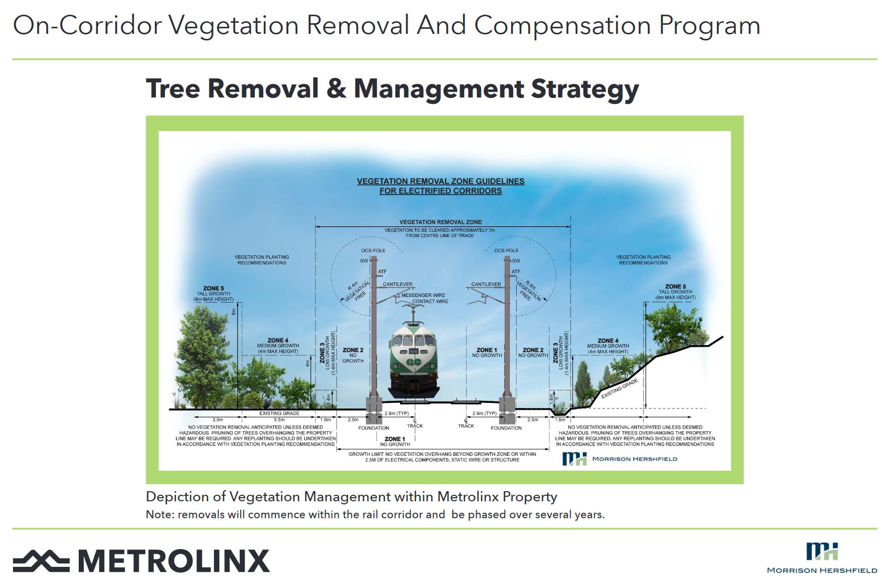
Here is a diagram showing the minimum clearances from adjacent vegetation (mainly trees) on an electrified GO corridor:
In a context where buildings are nearby, the diagram changes a bit, but the basics are similar.
These drawings show a two-track GO corridor, but Lake Shore East will have four tracks, plus the Ontario line tracks. If this view looked northeast, the OL tracks would be on the left side, probably to the left of the pole holding the overhead system.
In that configuration, the “no vegetation” zone to the left (west/north) would be occupied by the OL itself which should have much less restrictive requirements for nearby growth because it uses overhead power at a much lower voltage than GO trains. However, on the right (east/south), the outermost GO track is now at the edge of the corridor and clearance requirements for electrification apply. [Corrected March 28/21 to reflect overhead rather than third rail power supply.]
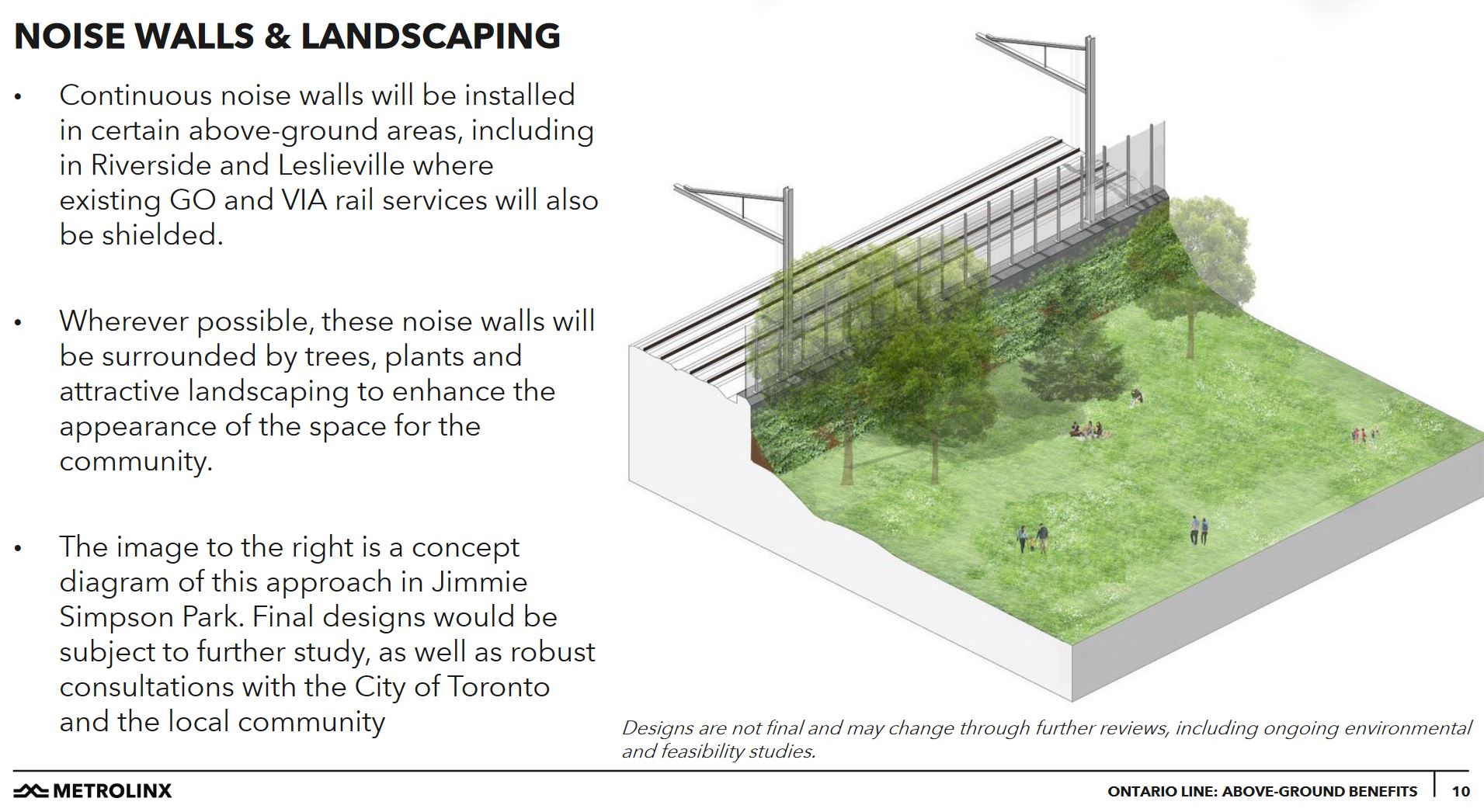
An illustration of a park on the line must be seen in this light. This shows a mature tree immediately beside the sound wall and the overhead support poles. As shown, it is within the clear zone required for electrification.
In the management presentation, Metrolinx claimed that the Ontario Line will actually make the neighbourhood quieter, although they did not explicitly say “quieter than today”. This is something of a stretch because there will still be more GO trains, and many of them (thanks to the Bowmanville extension of GO service) may well be diesel.
This is an example of a fundamental problem with Metrolinx planning for this corridor: they conduct separate studies and community sessions for the Ontario Line and for the GO Expansion and Electrification program rather than producing a consolidated plan showing the effect of all three changes planned over the coming decade.
A further exaggeration, intended to show how all of this work has a beneficial end even though it might affect the community, lies in claims of environmental and congestion benefits of the project (regardless of its alignment).
All of the new transit riders on the Ontario Line are assumed to represent avoided auto trips complete with their congestion and pollution. There is no guarantee that fewer auto trips will be taken in the future due to a backlog of demand for road space, and due to population growth.
A common remark Metrolinx has made about The Big Move regional plan is that it will at best keep things from getting worse. In areas where there is already heavy traffic and congestion, it is not realistic to assume that the day the OL opens, roads will suddenly empty of cars. This is a bogus position, and Metrolinx should know better.
The original Ontario Line scheme was sold on its benefits for GO interchange and because it was claimed to fit within existing Metrolinx lands, more or less. Gradually these claims are coming unglued, although many of the underlying issues were clear the day the line was announced.
Postscript: An Alternate Alignment from the Don River to Carlaw
In my previous article, I alluded to a possible alignment that would splice the Ontario Line into the Relief Line’s alignment running up Carlaw from Eastern. From East Harbour, the OL would have travelled east parallel to Eastern Avenue and descended below grade, then veer north to hook into the Relief Line route at about Logan Avenue.
This scheme depended on the Ontario Line being entirely on the south/east side of the rail corridor at East Harbour rather than astride it (as in the original OL plan) or on the north/west side as in the revised plan.
With the proposed shift of the Ontario Line to be entirely on the north/west side of the rail corridor, this scheme is no longer feasible.