
Detailed study of the southern portion of the proposed Relief Subway Line from Pape & Danforth to Osgoode Station is now underway including public consultation sessions on the design. Two of these have already occurred as I write this on April 29, but one session does remain:
Monday, April 30, 2018, 6:30 to 8:30 pm at Morse Street Junior Public School, 180 Carlaw Ave (south of Queen)
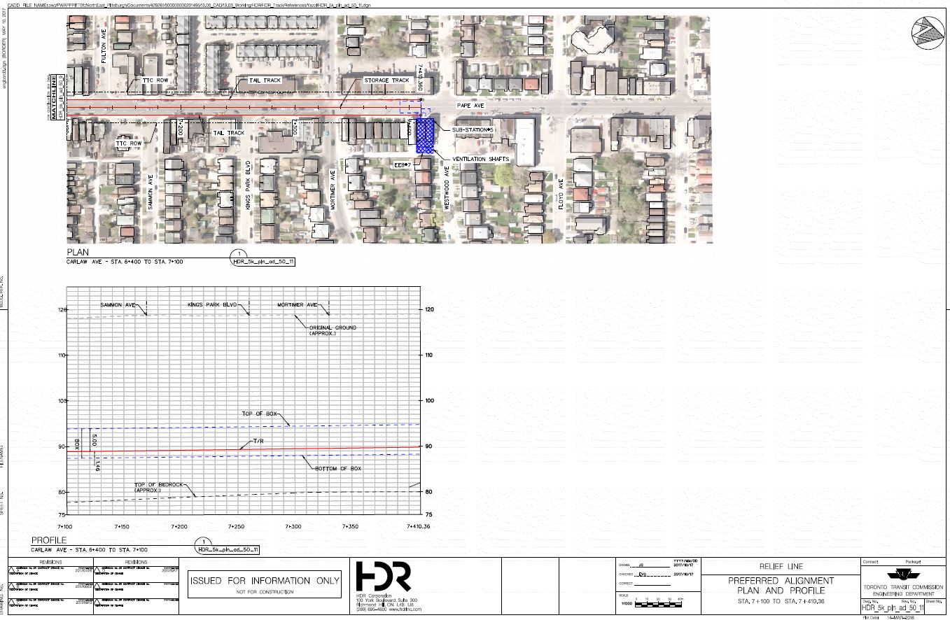
The first session was held near Pape & Danforth on April 23, and it was a packed house because construction of this line will have a major effect on properties along the route through Riverdale. Much of the detailed information is not available online because of the size of the files. This article contains snapshots of station and alignment plans along the route at a resolution sufficient to see the details while staying within reason for online viewing. (All of the illustrations are clickable to see a larger version. Some of them have artifacts of viewing large files at a reduced scale, notably the partial graying-out of some text.)
Commentary on the designs is my own except as noted.
Thanks to the City of Toronto Planning Department for provision of the electronic versions of the plans from which the illustrations here are taken.
For further information, please see the Relief Line South website.
A few questions about the new line are separate from the actual design. The answers below are taken from an email response from City Planning.
Q: At one point there was talk of a connection track under the GO corridor branching off near Gerrard Station. I don’t remember seeing any report where this was explicitly discarded, although the location of Gerrard station now that there is a dogleg from Pape to Carlaw could affect the design of any connecting track. This is directly related to the effects of the wye design at Danforth, and whether there has been any analysis of the comparative impacts and costs of the two schemes.
A: In discussion with TTC operations, particularly with respect to yard capacity, it was determined that Greenwood Yard would not be able to accommodate the additional fleet requirements of the RLS and therefore storage would have to be provided on the line. The potential connection between Gerrard and Pape running under the GO Corridor would require a portal in Greenwood Yard that would significantly impact the current yard design and capacity as it requires a substantial footprint. To be cost effective it would have to be a single track connection which would offer no redundancy. In addition there were substantial risks involved from a structural and approval perspective to go forward with this option based on conceptual design.
Q: Will the streetcar services, after having been shut down, ever reappear? For Queen this doesn’t make sense because access to the east end carhouses requires this. For Gerrard, an assumption that somehow the rest of the Carlton line is expendable because the RLS manages to intercept some riders at Carlaw is rather short-sighted.
A: There are no plans to eliminate any streetcar service as part of this project. While streetcar ridership between Carlaw and downtown may be reduced, it may increase east of Carlaw as more people connect to the new subway. This phase of the Relief Line will have no effect on the very busy demand on the same streetcar routes west of downtown.
Q: This begs the need for something more definitive from the TTC including plans for maintaining service to the degree possible during construction. There is also the question of the relative timing of construction of lines in the waterfront including the Broadview connection and the Cherry extension linking up to Queens Quay. There really is the sense that a goodly chunk of the streetcar system can simply be shut down to accommodate the DRL construction. Comments please.
A: As design progresses, the construction methods, impact and schedules will be further developed and will inform temporary service changes during construction.
Service is expected to be maintained during construction, either by using replacement buses or by diverting streetcars. It will be a priority to maintain access to the two east end carhouses and provide necessary alternative streetcar routings. There will also be efforts to coordinate construction of multiple projects, if possible.
Vertical Alignment and Tunnelling
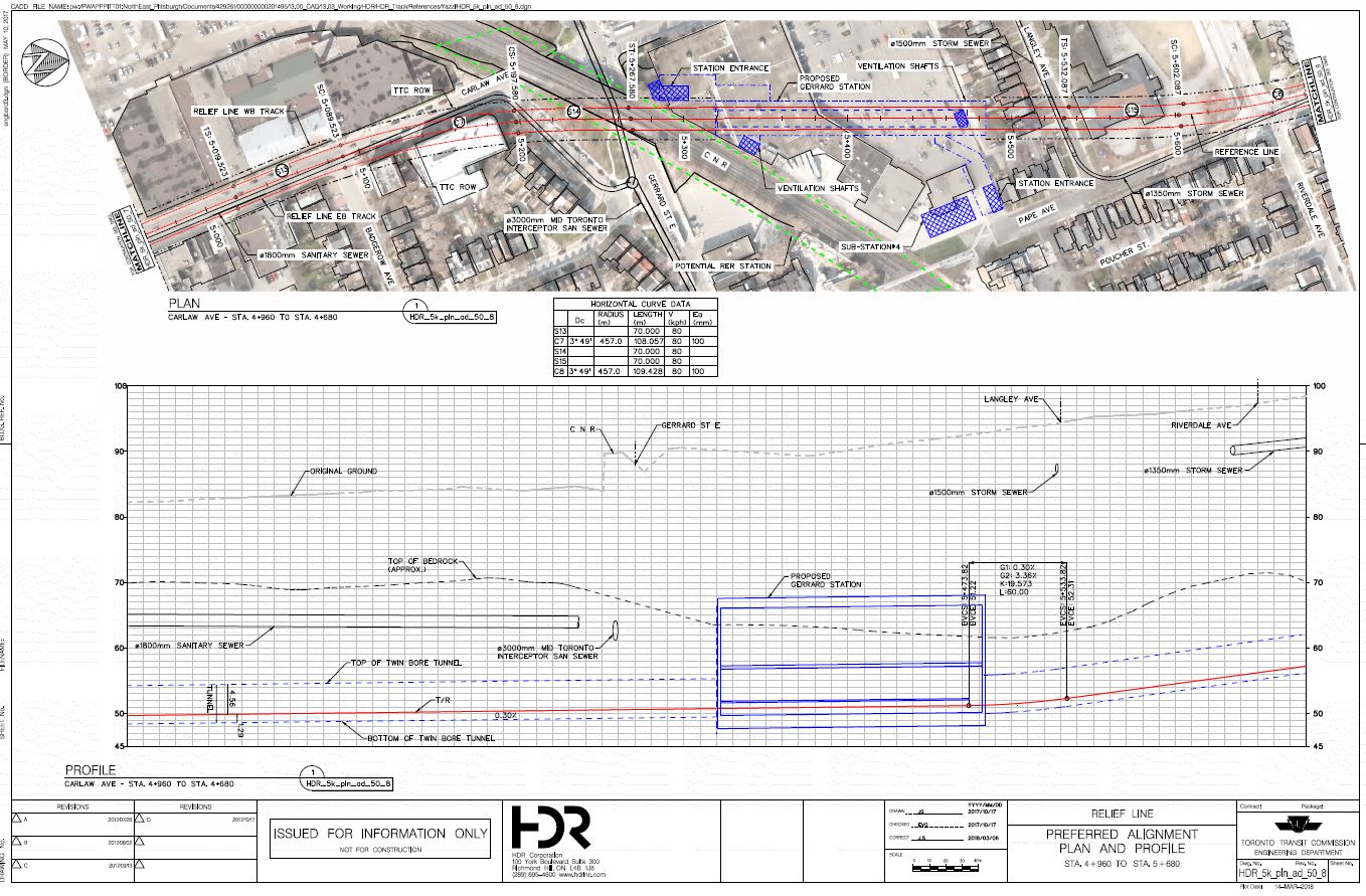
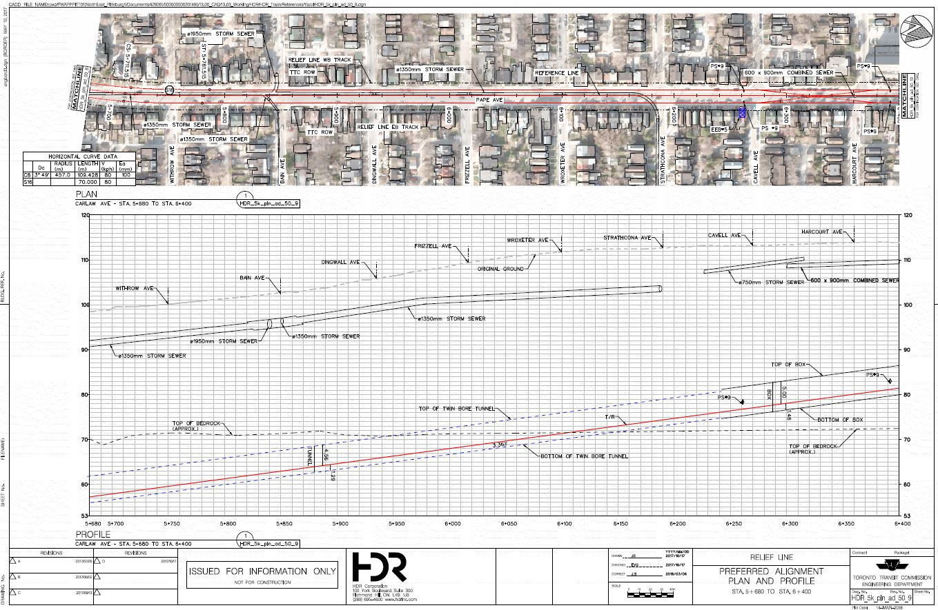
Through much of the alignment of the Relief Line South (RLS), the line will be tunnelled through bedrock, unlike all previous lines in Toronto which have avoided going that deep. The level of bedrock is shown on the alignment drawings.
This has advantages including the avoidance of existing utilities, better stability for construction near existing buildings, and better noise isolation. The tradeoff is that some of the stations are quite deep, and this will add to access time between the surface and platform level, and even between platform levels at interchanges. The short vertical links well known at Bloor-Yonge and St. George are not the kind of connection one will find for the RLS.
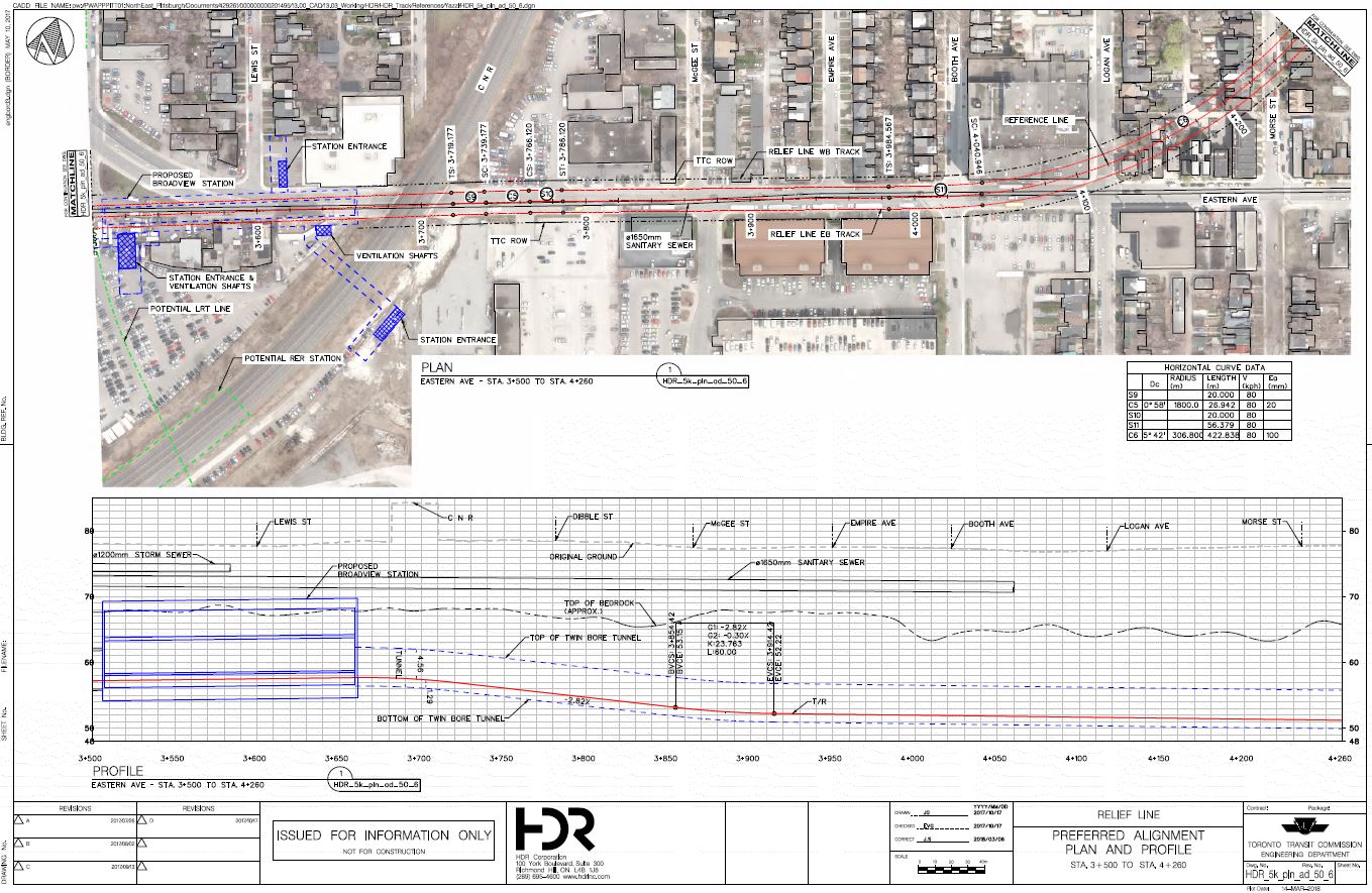
The tunnels would be built in two drives from a common launch site at the future Broadview-Eastern station location. One pair of TBMs will drive west toward Osgoode Station while the other pair drives east and north to Pape Station. The latter two machines would be plucked out of the north tail track area at Pape Station, turned around, and then would drive south and around the curves forming the wye linking with the existing Danforth Subway.
All of the stations are designed for full six-car train operation.
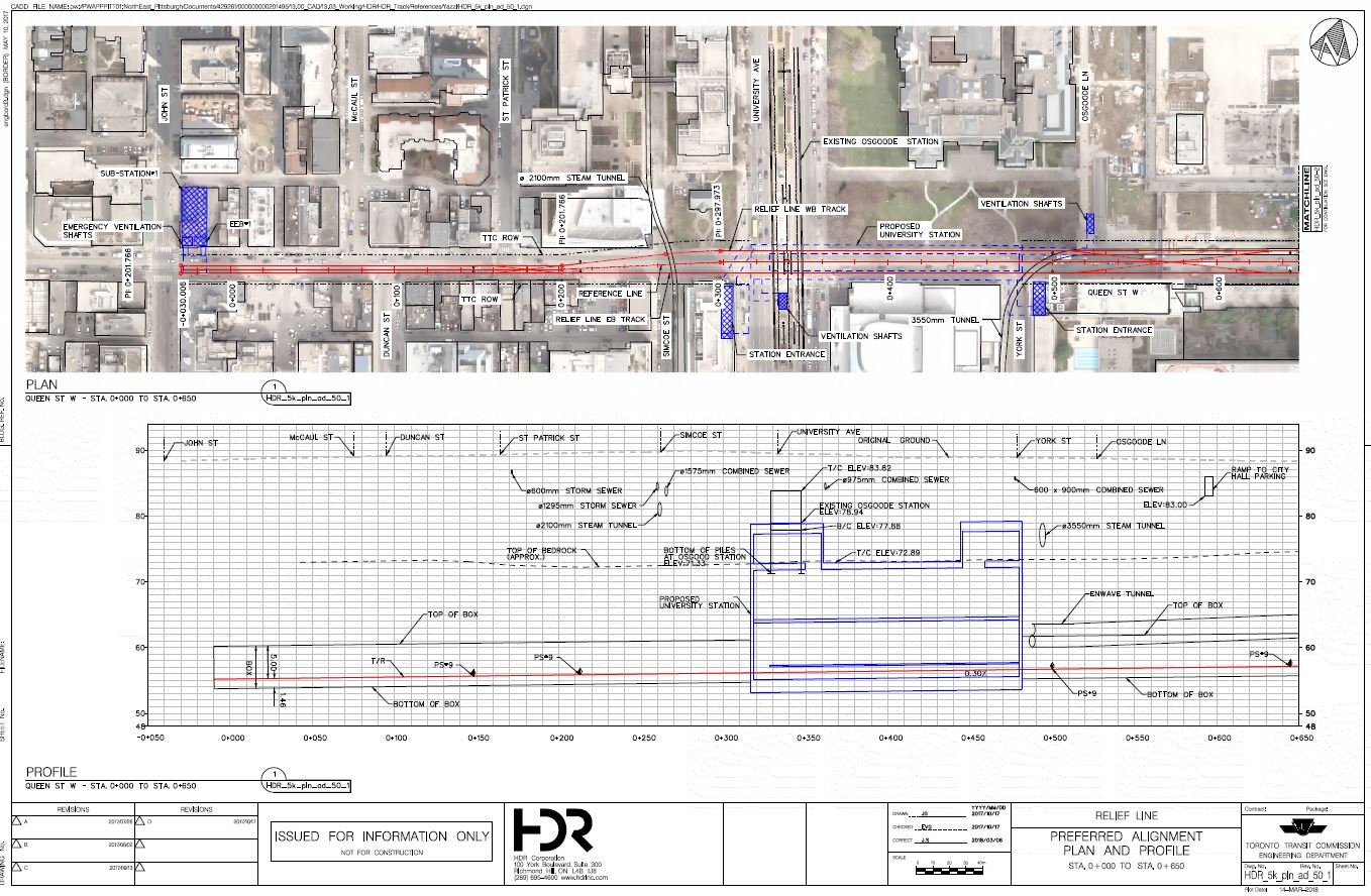
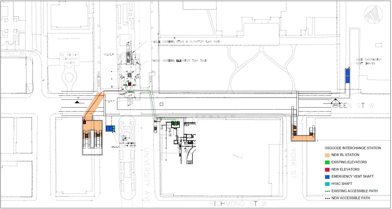
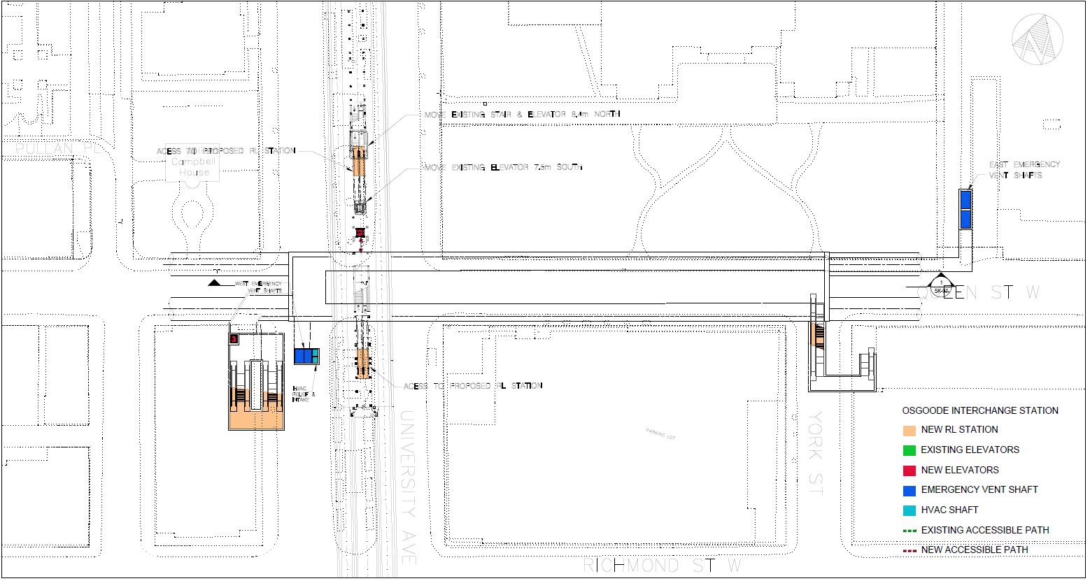
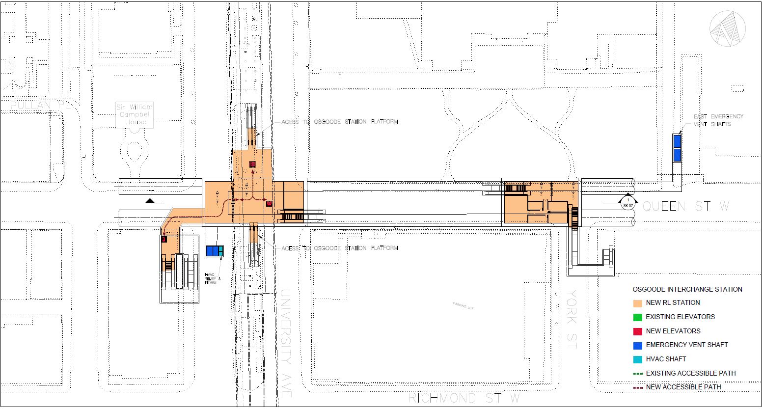
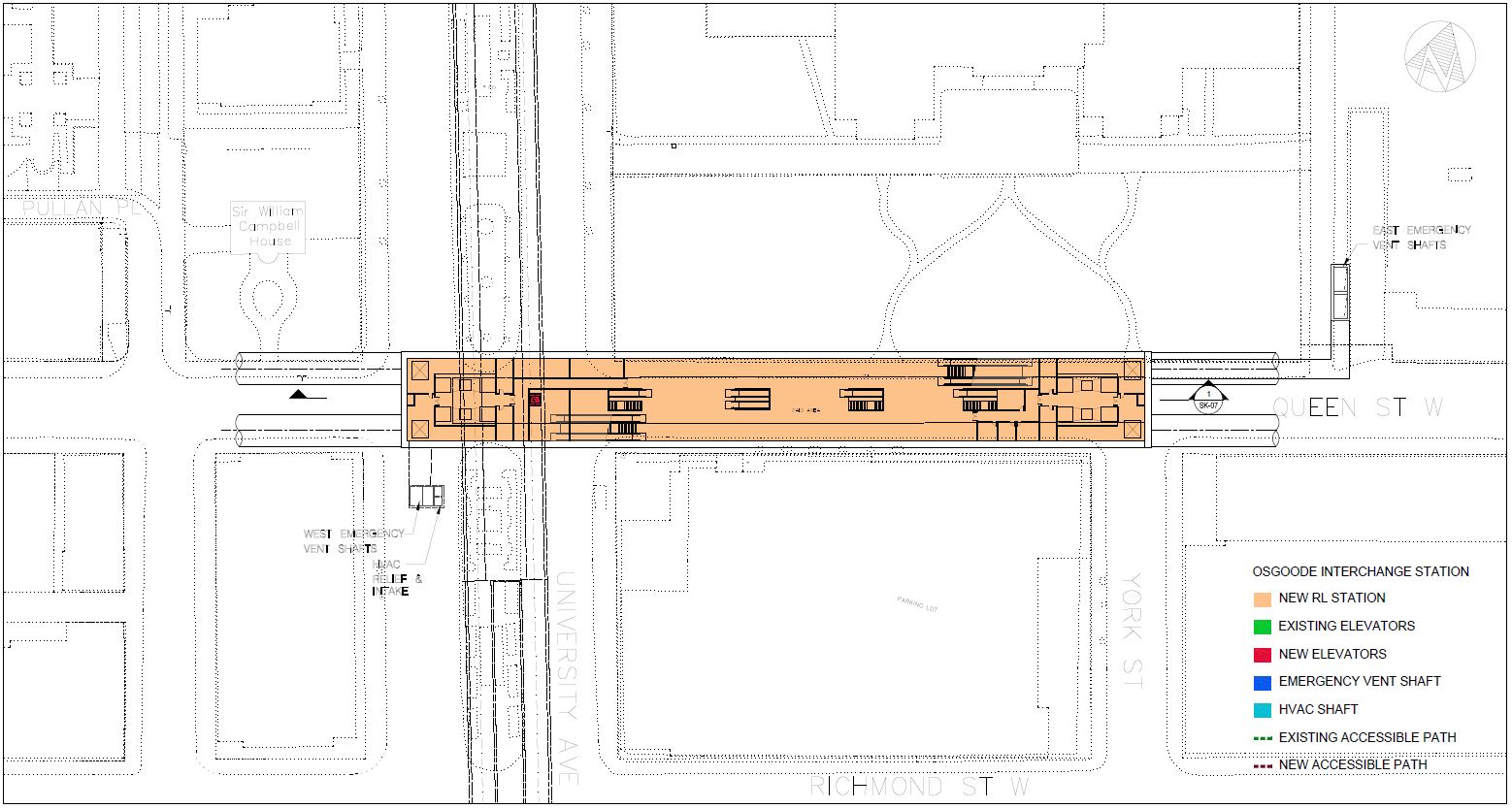
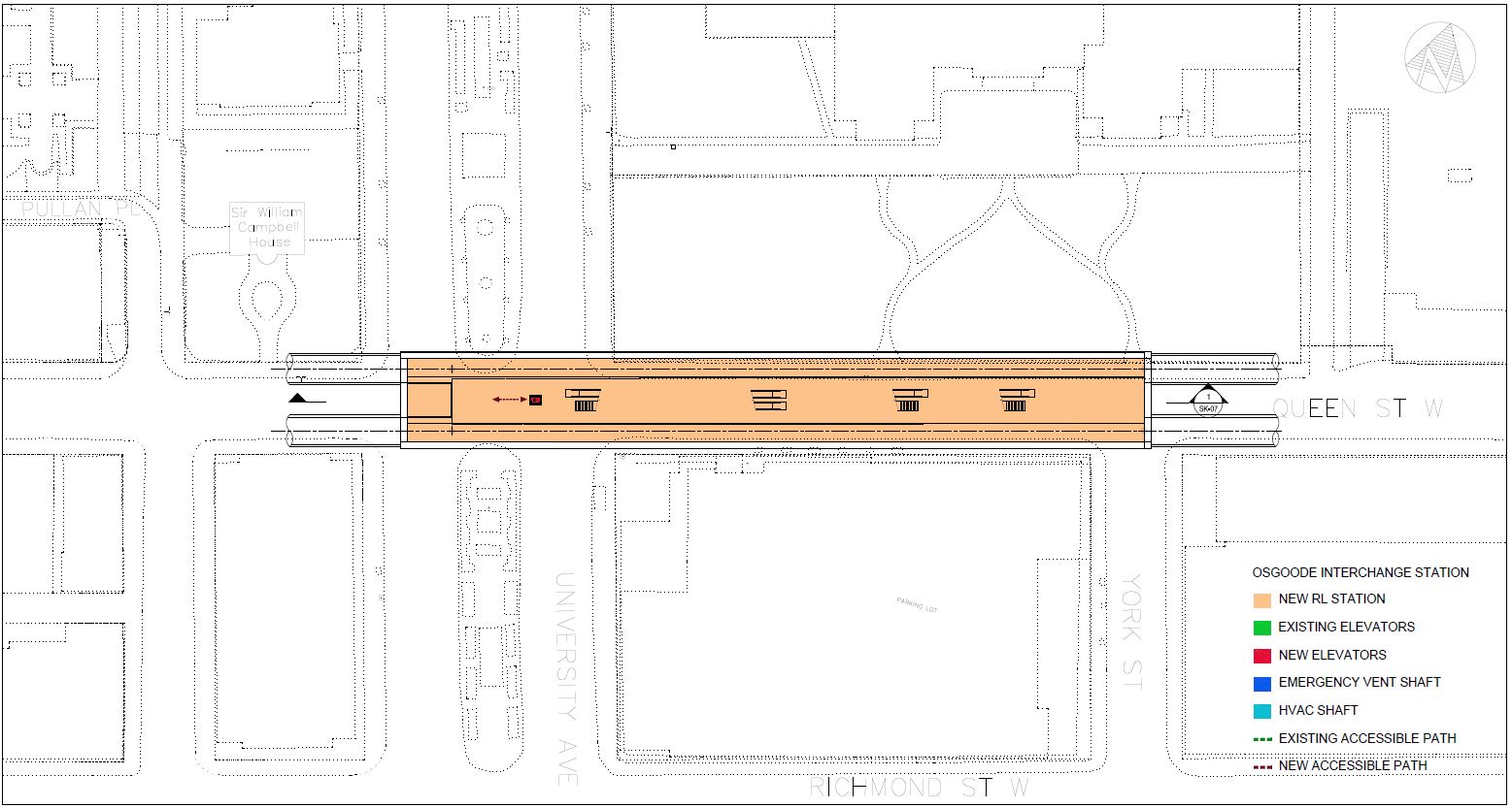
Osgoode Station
The western terminus of the RLS will connect with the existing Osgoode Station on the University Line. The station itself lies generally between University Avenue and York Street, but the structure extends west to John Street to provide for tail tracks west of the station.
New entrances would be provided through the building on the southwest corner at University (replacing existing street entrances) and at the southeast corner at York. The drawings below show the street level plan followed by details of the horizontal and vertical alignments of the structure.
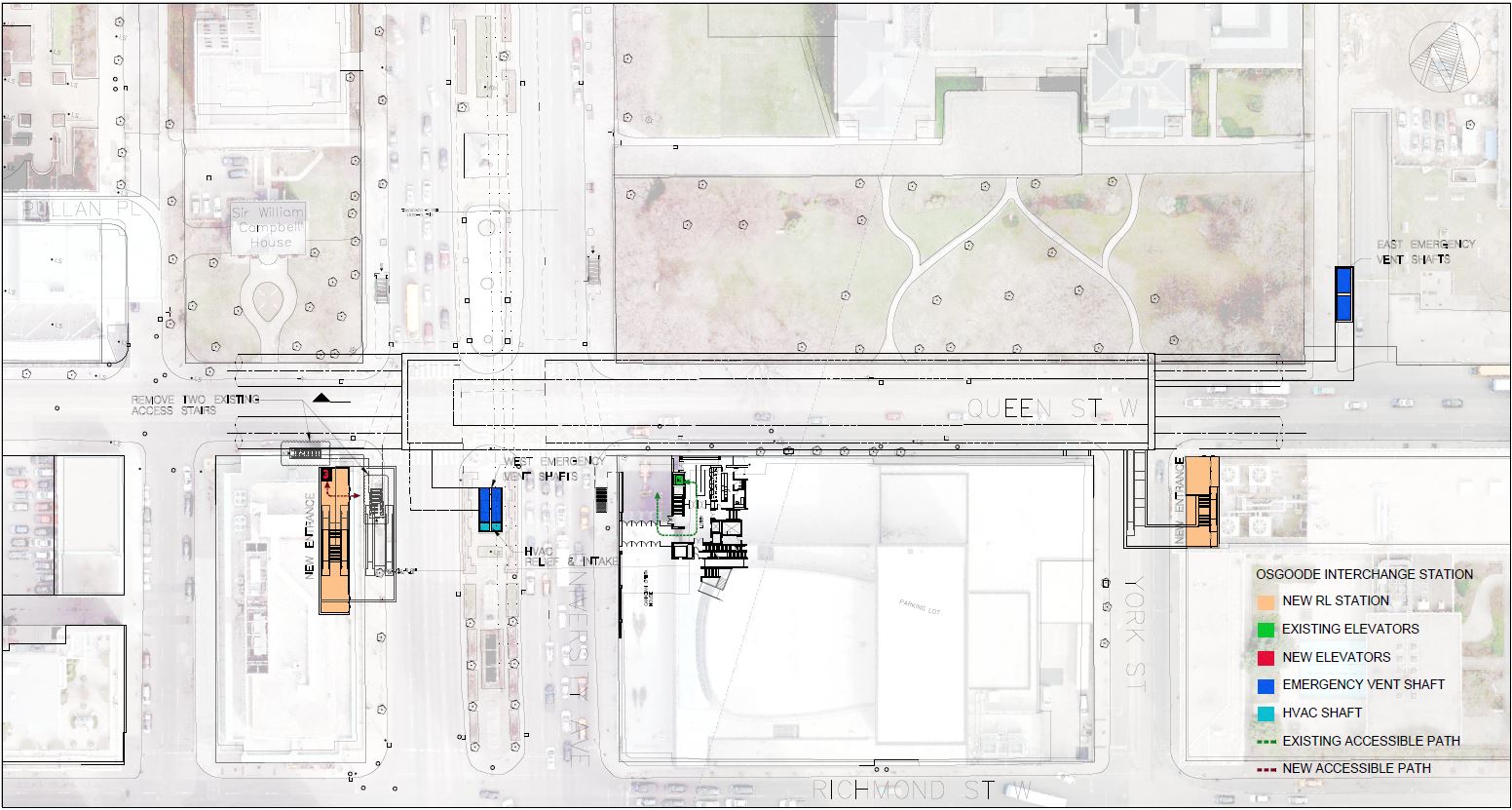
The station is quite deep because it passes under the existing subway which is the small box in the upper left of the cross section looking north through the station (below).
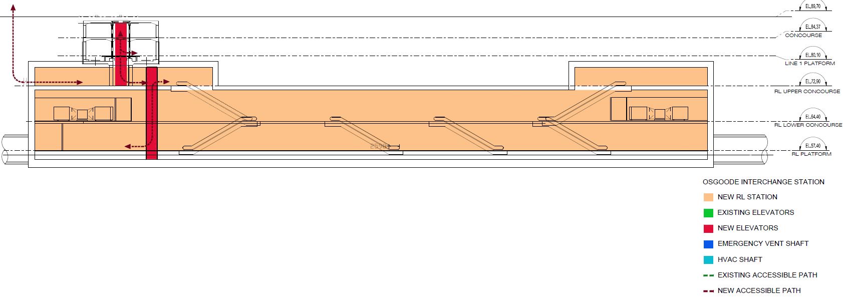
One level down from the street is the existing concourse of Osgoode Station including the main fare control area.
The next level down is the existing Line 1 platform level.
Below the existing subway level are two mezzanines. The upper level is not continuous, but it makes the transition from the entrances and the link to the existing station down to a second mezzanine running above platform level.
Finally at the lowest level is the new station platform.
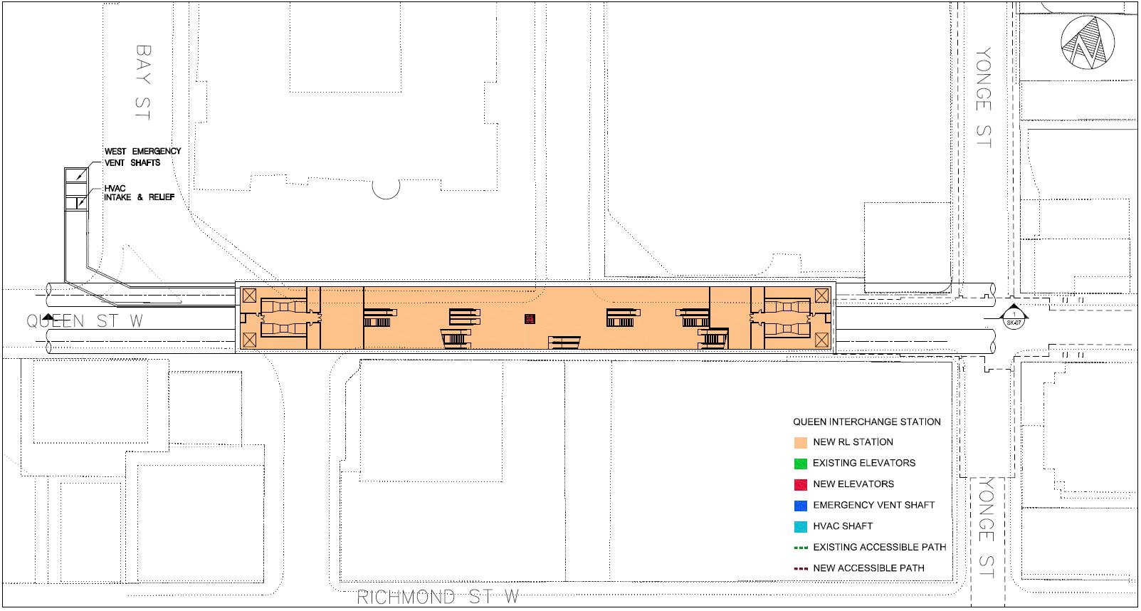
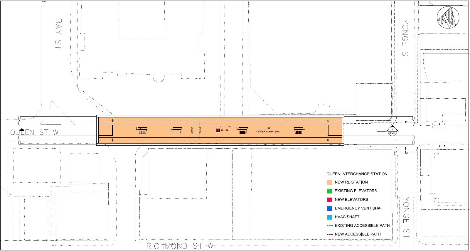
City Hall Station
This station goes by the more prosaic name of the Queen Interchange Station in the drawings, but I have used the more political of the names. The new station would lie between Bay and Yonge Streets beside Old City Hall and flanked by the Eaton’s and Simpson’s buildings at the eastern end.
The new structure does not use the existing underpass at Queen Station which was originally provided for a streetcar subway.
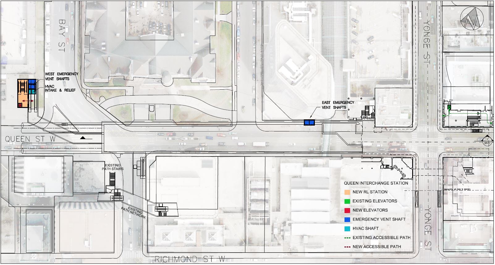
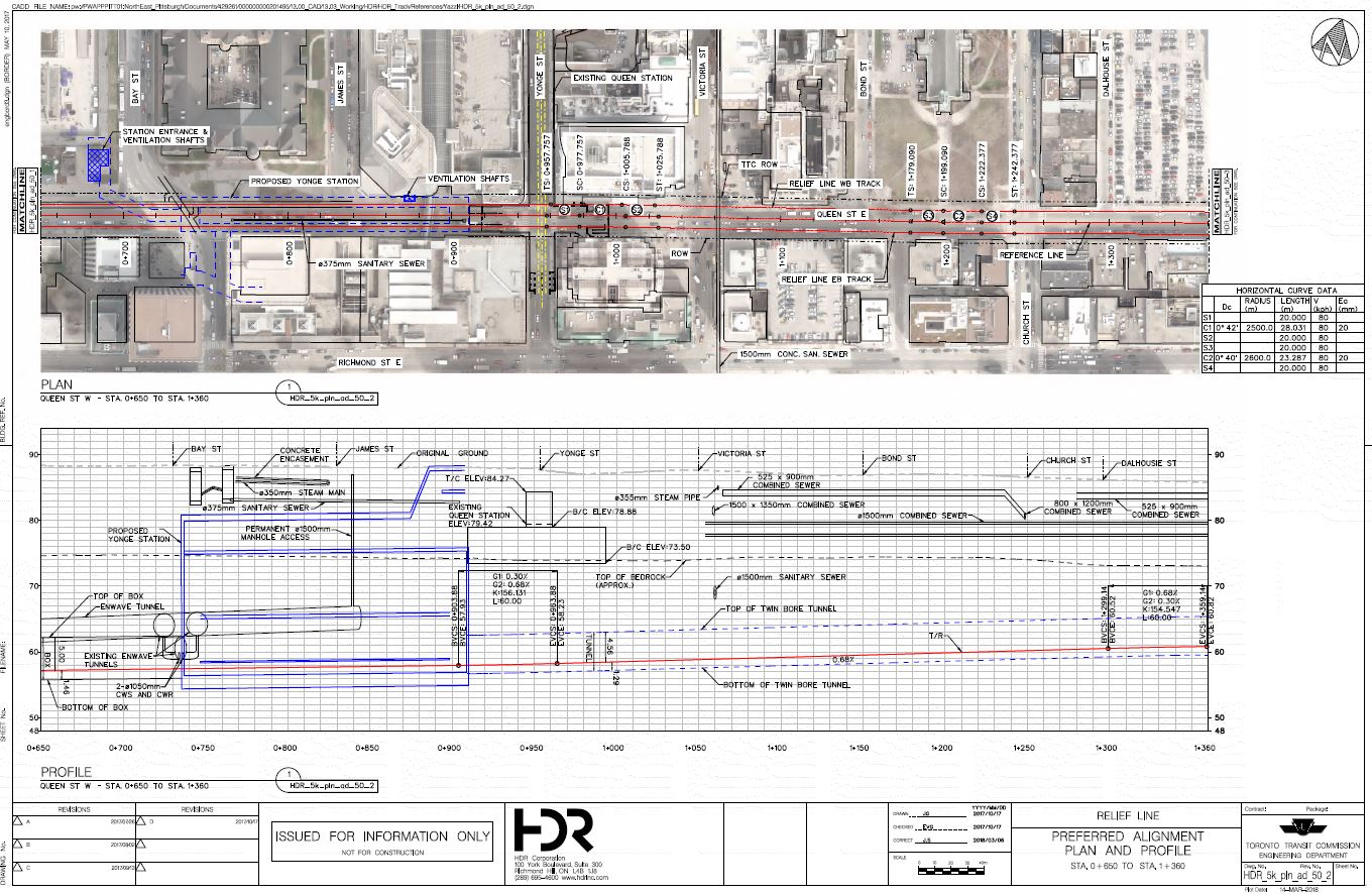
The existing subway including the underpass (original Queen streetcar subway) is on the right side (east) of the cross section below that looks north through the structure. The streetcar subway, had it been built, would have been much shallower than the RLS. With the new station well west of the existing structure and three levels below the platform level at Queen Station, transfer connections between the Yonge line and the RLS will not be as straightforward as at Bloor-Yonge.
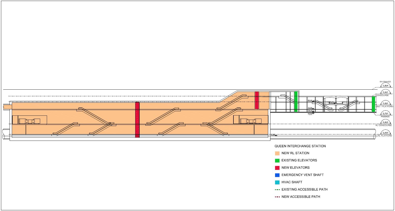
Little of the new structure is at the “one below” level corresponding roughly to the level of the pedestrian underpass crossing Queen between the department stores.
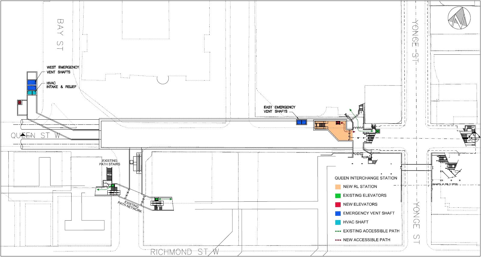
The next level down is at the level of the existing “Queen subway” underpass at Yonge Street and connects into it. This is the transition between the paid and unpaid areas of the new station. This concourse provides a link through to an exit building on the southeast corner of Nathan Phillips Square as well as a link into the existing PATH network at Bay Street.
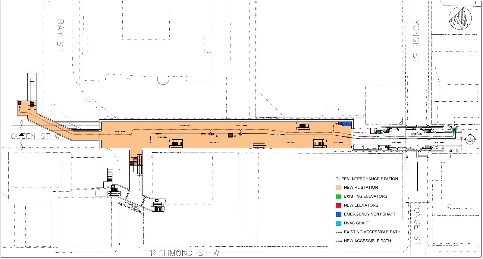
Beneath the new fare concourse is an intermediate level, and finally …
… the new station platform.
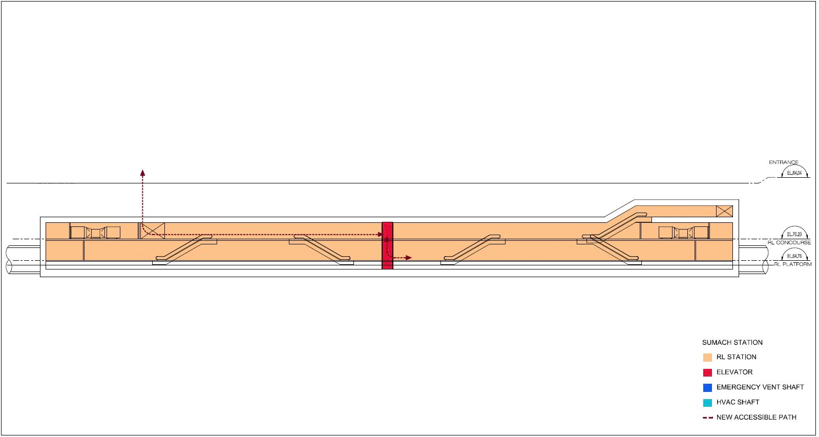
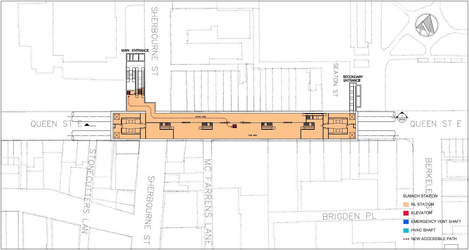
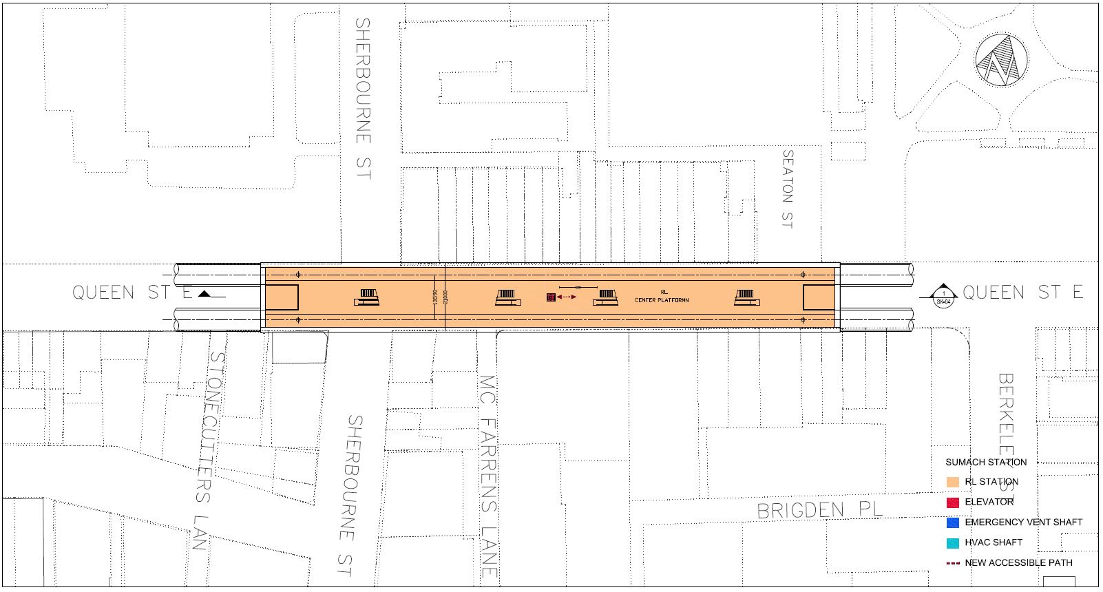
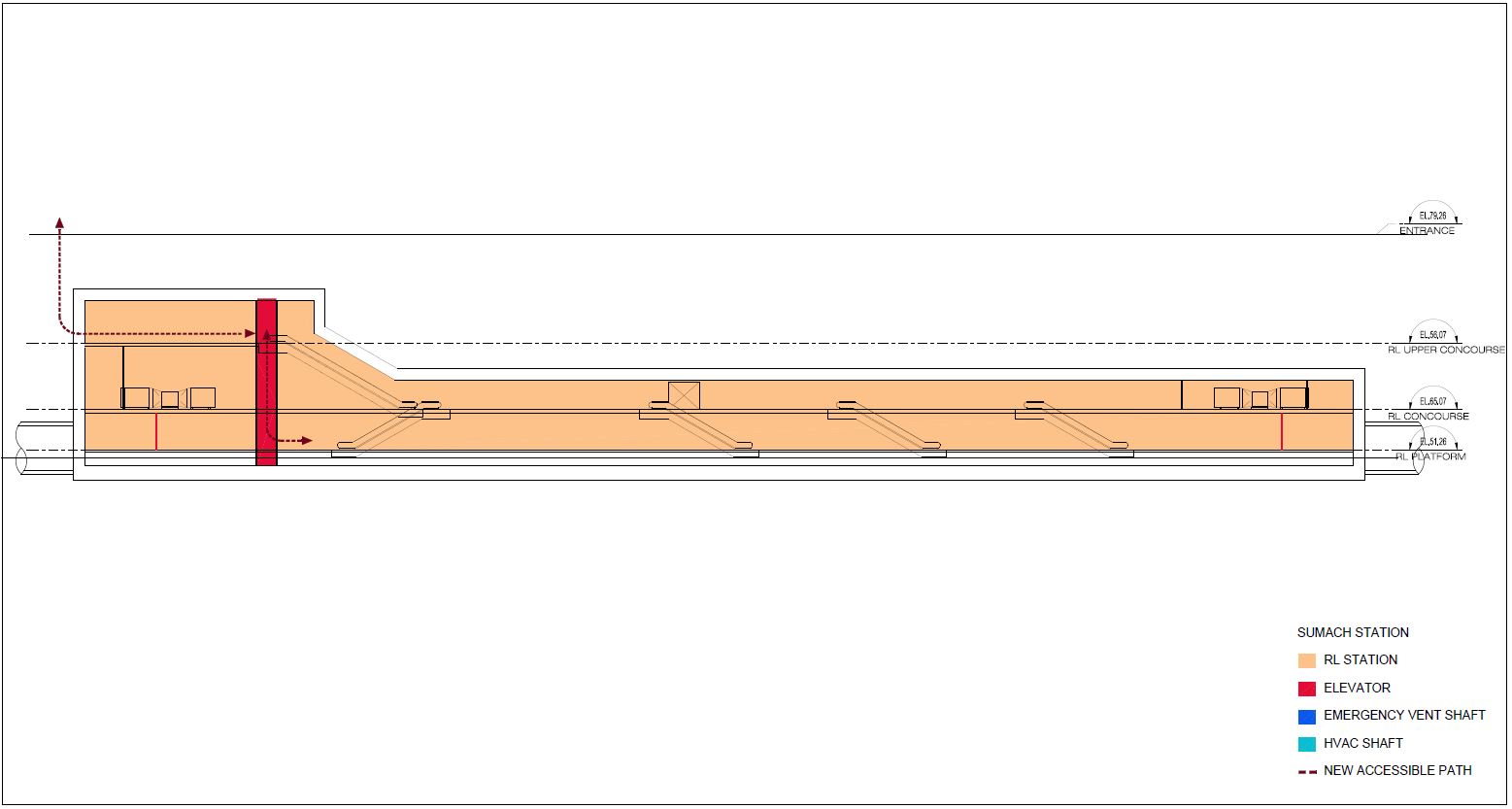
Queen-Sherbourne Station
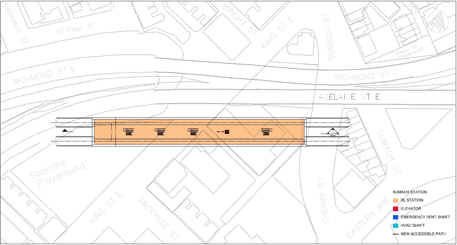
Note that in some of the drawings below, this station is mislabelled “Sumach Station”.
The new station at Queen & Sherbourne lies primarily between Sherbourne and Seaton Streets with the principal entrance on the northwest corner at Sherbourne.
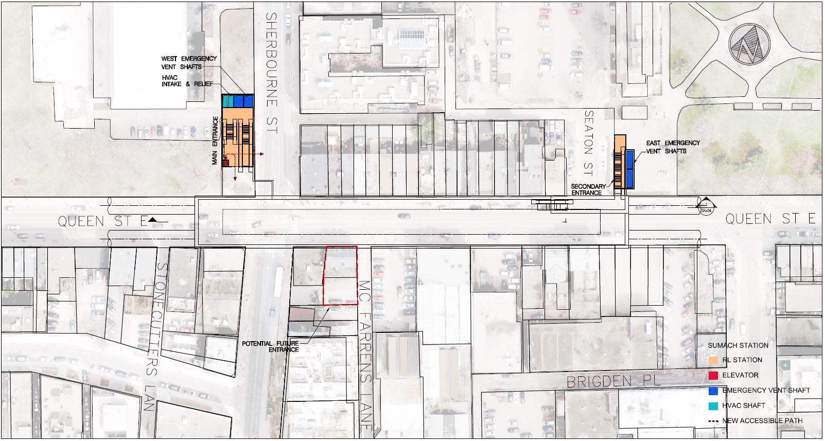
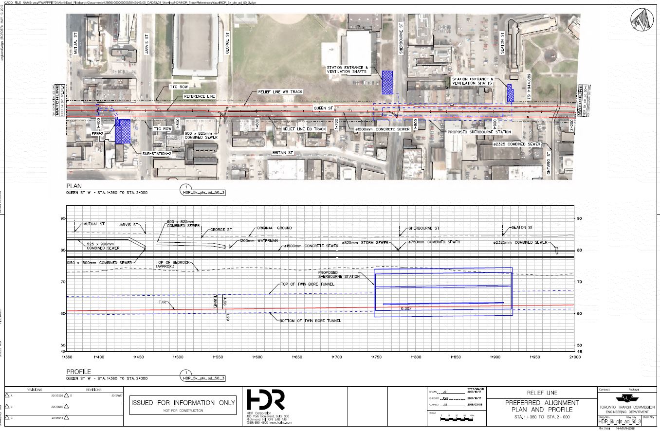
The station is structurally simpler than the interchange stations to the west. From the entrances, one descends to the fare control level, and then once more to reach the platform.
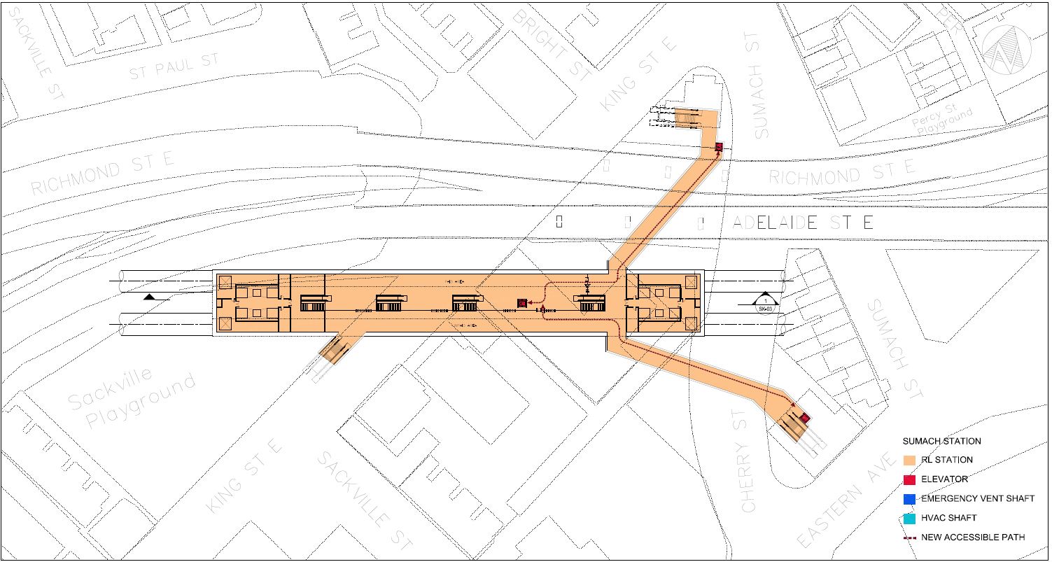
King-Sumach Station
After leaving Sherbourne Station, the route veers southeast and passes under King Street just west of the Eastern Avenue flyover (aka the “Duke and Duchess Interchange” after the original names for Richmond and Adelaide Streets). The station is unusual in having exits that are not directly above the structure, but which are linked to a common fare control concourse. The station is also shallow compared to others on the RLS.
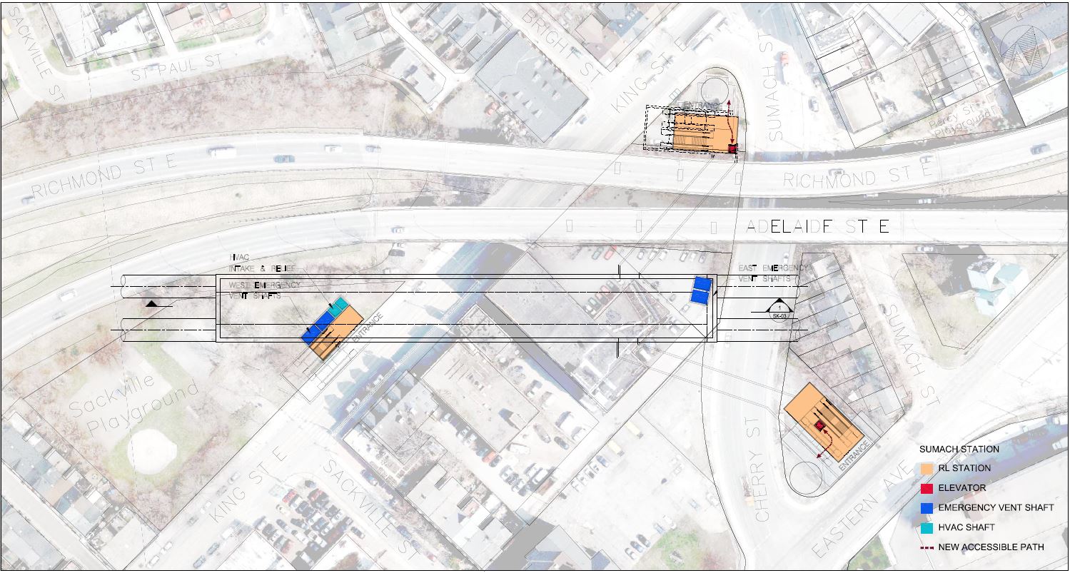
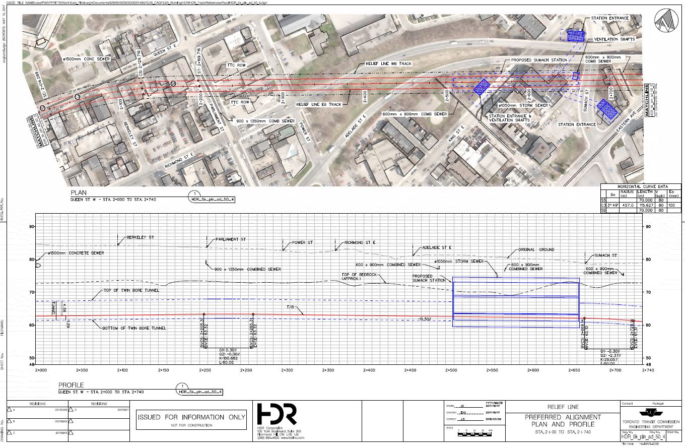
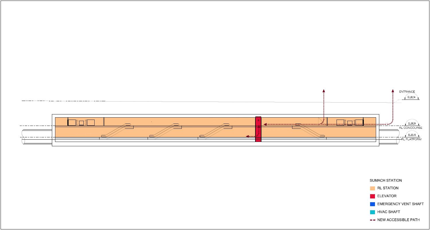
The fare control level links through tunnels to entrances fronting on Eastern Avenue and on the King/Sumach corner, as well as directly to an entrance on King at the Sackville Playground.
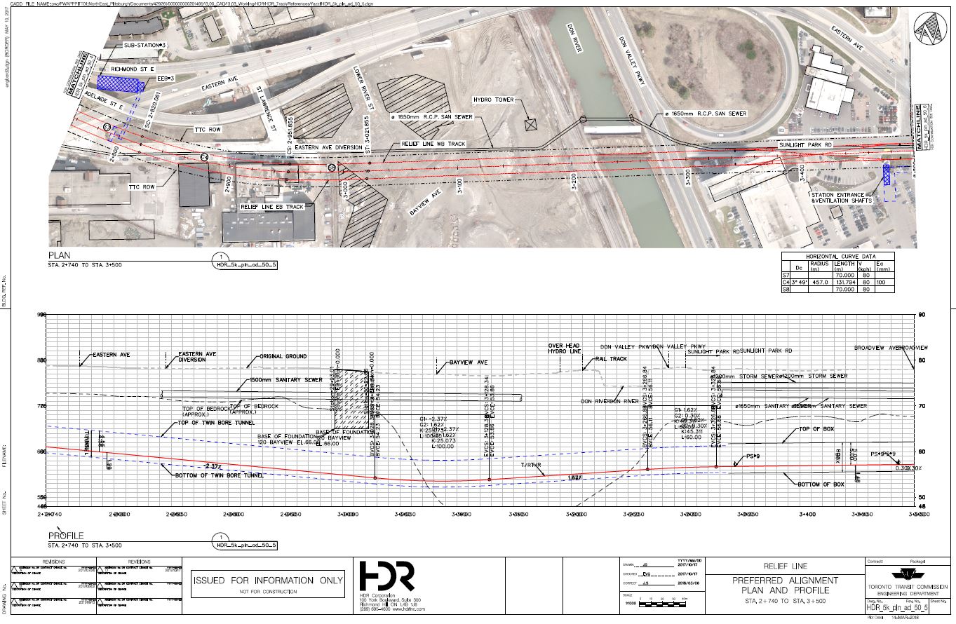
Don River Crossing
The Don River crossing occurs well below the level of the river but still above the bedrock which deeps quite dramatically at this location. The line goes under a new building at 120 Bayview Avenue. East of the river, the tunnel follows Sunlight Park which merges into Eastern Avenue. The new East Harbour development is south of this location and will be served by the Broadview-Eastern Station (below).
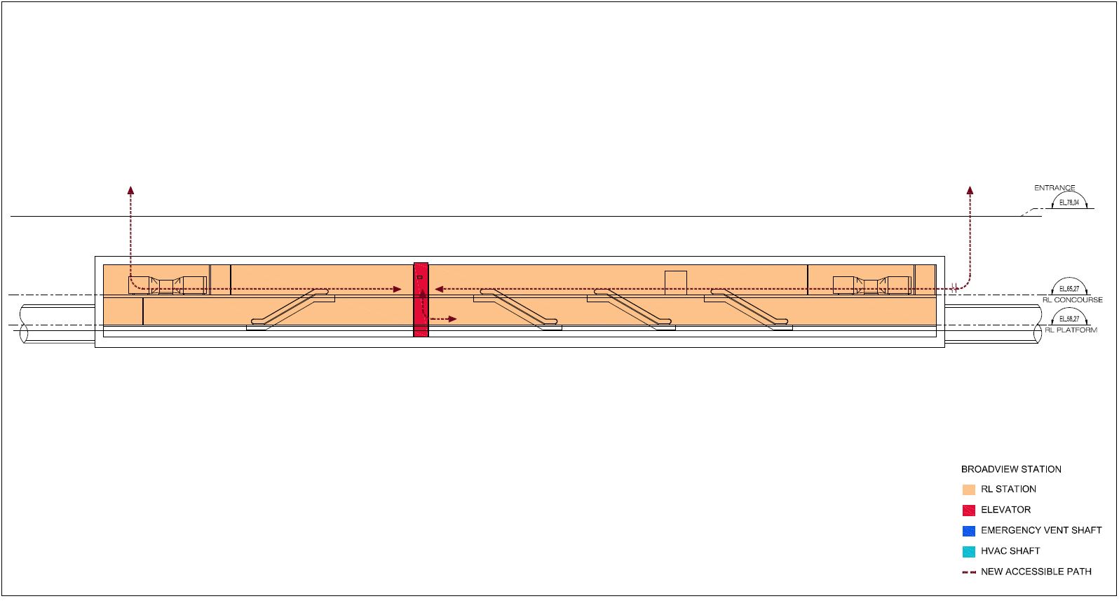
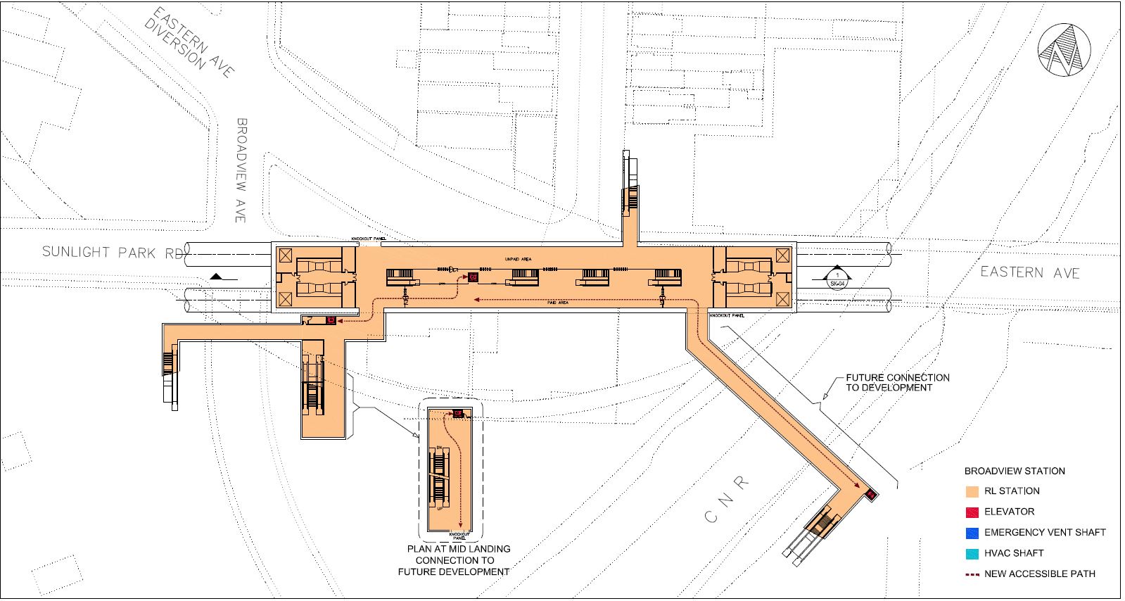
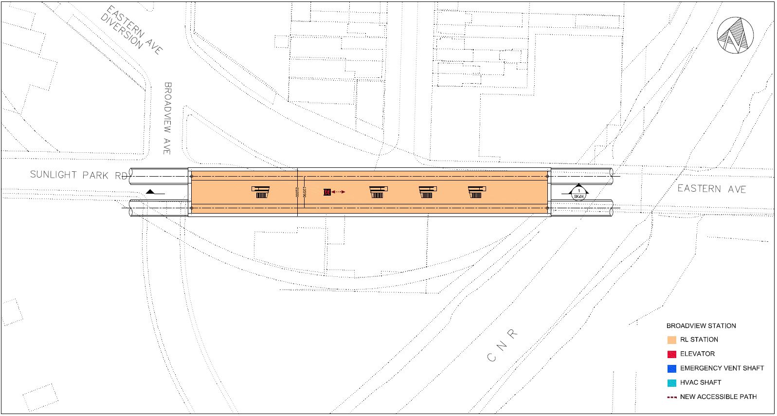
Broadview-Eastern Station
The station at Broadview & Eastern will connect with many things that do not exist today:
- The East Harbour development on the Unilever lands between Eastern Avenue and Lake Shore Boulevard.
- A new GO/SmartTrack East Harbour Station.
- The proposed southerly extension of streetcar service from Queen & Broadview to Commissioners Street.
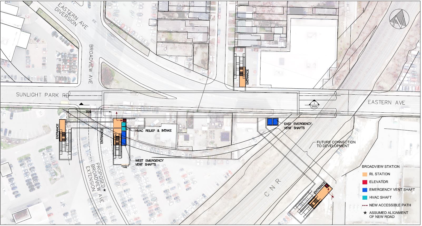
East of the new station the line continues under Eastern Avenue, and then turns north under Carlaw.
The station structure is fairly simple with two below-ground levels, one for fare control and circulation, and the platform level below.
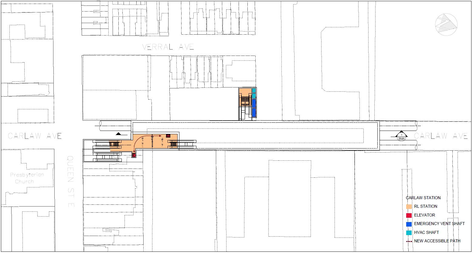
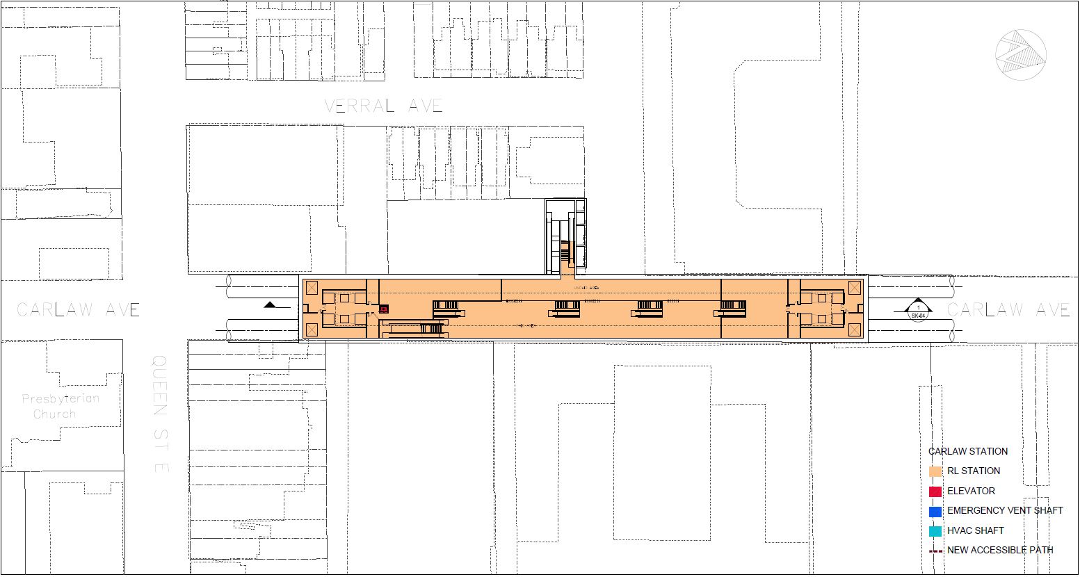
Queen-Carlaw Station
The station at Queen & Carlaw lies north of Queen Street with a primary entrance on the northeast corner.
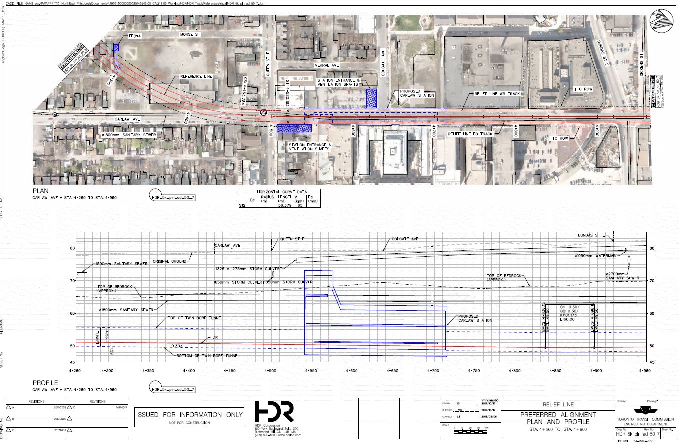
Down from the station building at Queen, the station has two levels: a fare concourse and then the platform. The secondary entrance on the west side of Carlaw connects into the concourse level.
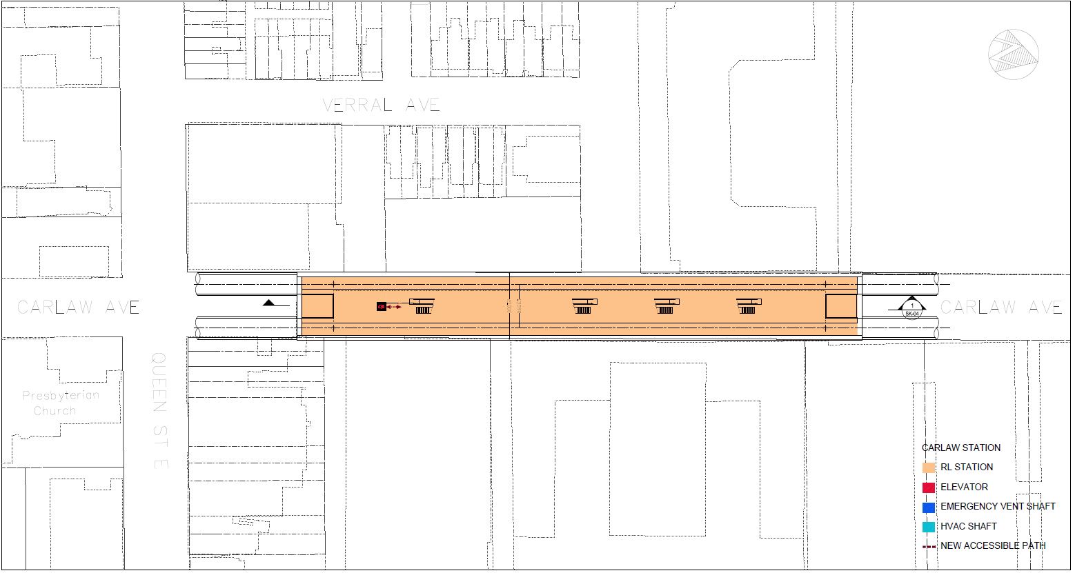
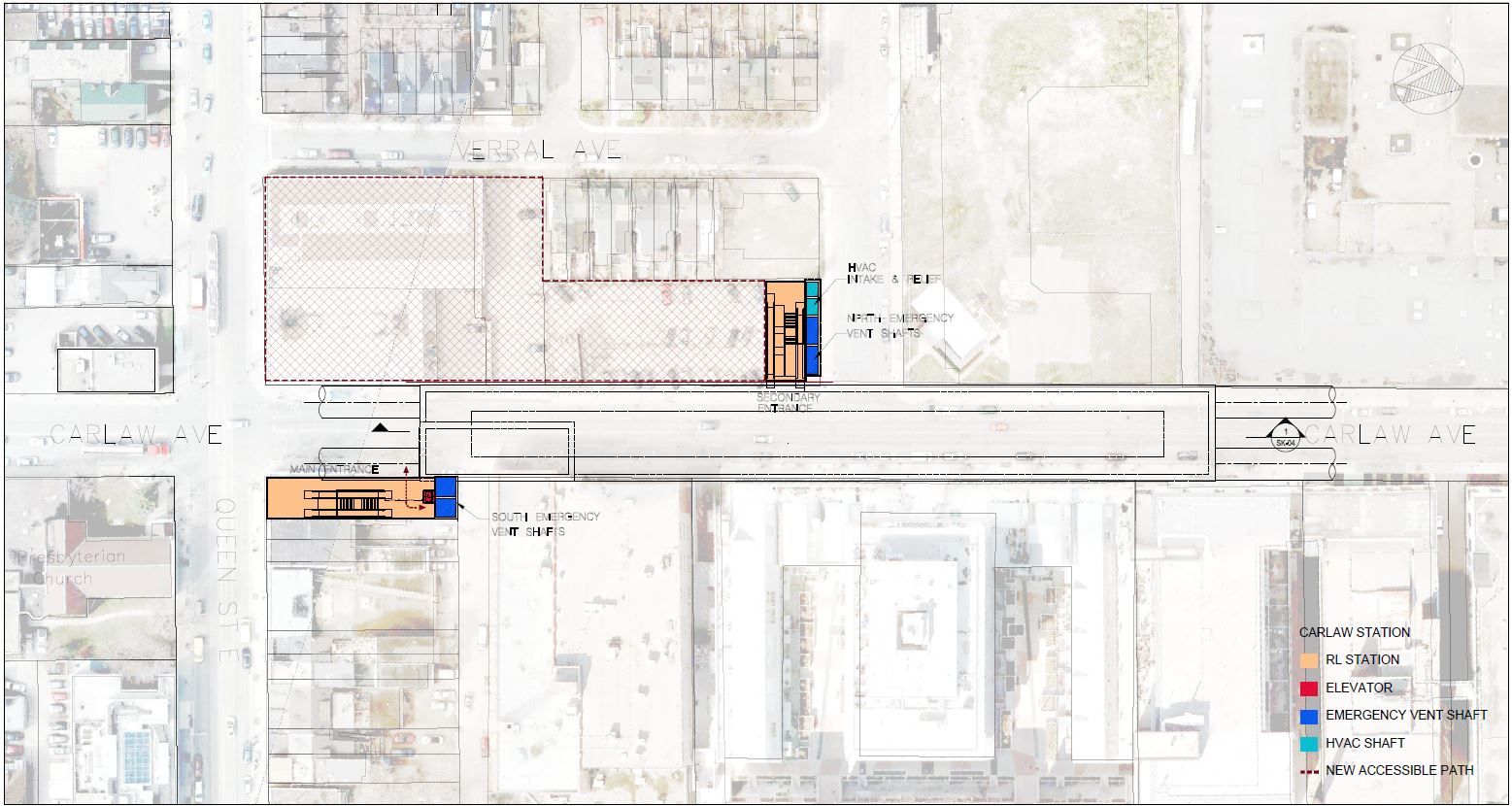
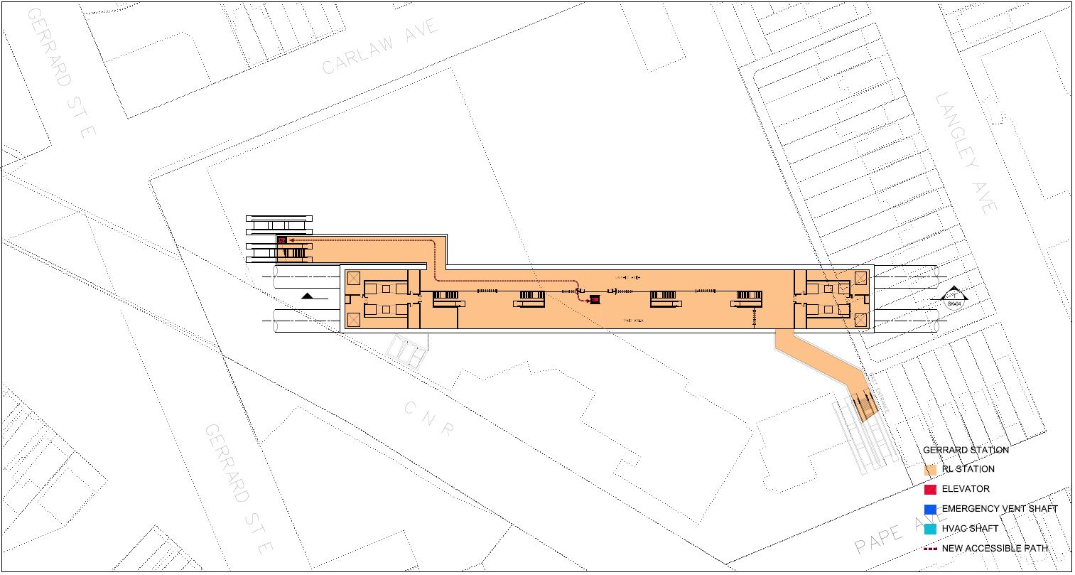
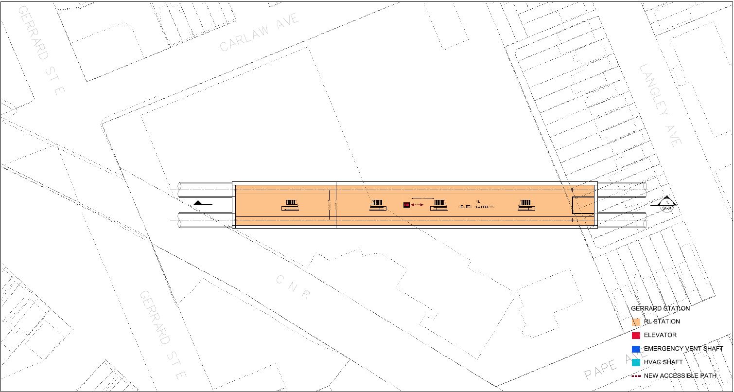
Gerrard Station
The station at Gerrard & Carlaw is fitted into the existing mall site and its parking area with the principal entrance on the northeast corner at Gerrard and a secondary entrance onto Pape Avenue south of Riverdale Avenue. No details are shown for links with the proposed Gerrard GO/SmartTrack station.
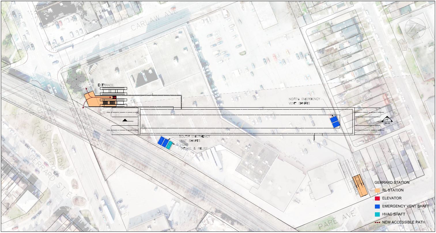
The station is quite deep to stay clear of major sewer lines including the Mid-Toronto Interceptor. North of Gerrard Station, the line begins its climb to Danforth Avenue.
The station entrances at street level are well above the mezzanine of the station and the platform below. This will not be a quick transfer connection with surface transit, and projections for this to be a major interception point for streetcar travellers headed downtown could be optimistic.
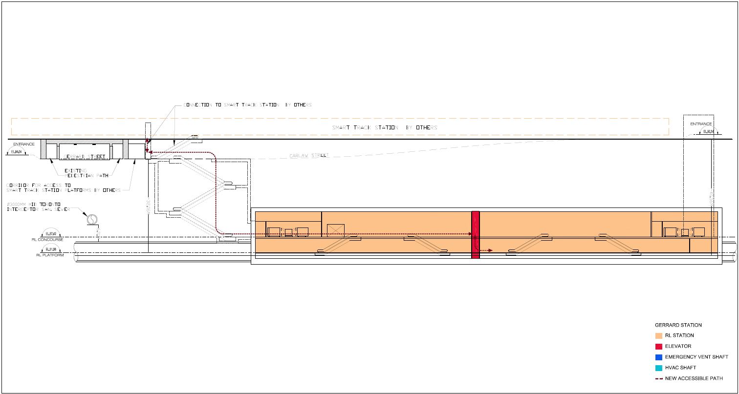
At the mezzanine level, the two station entrances link into the fare control concourse, and thence to platform level below.
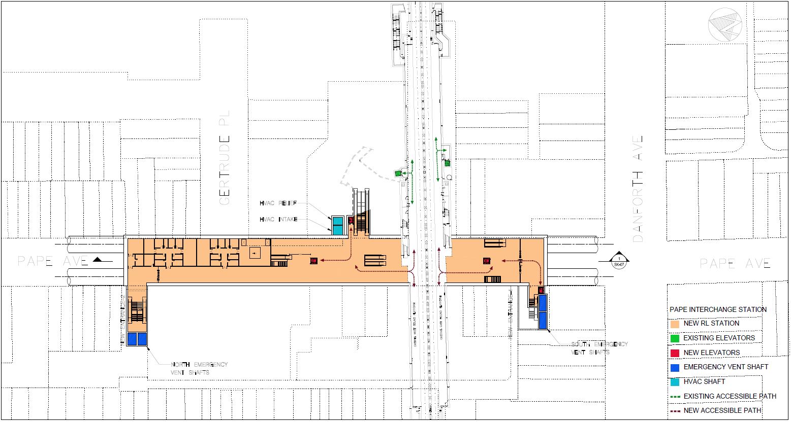
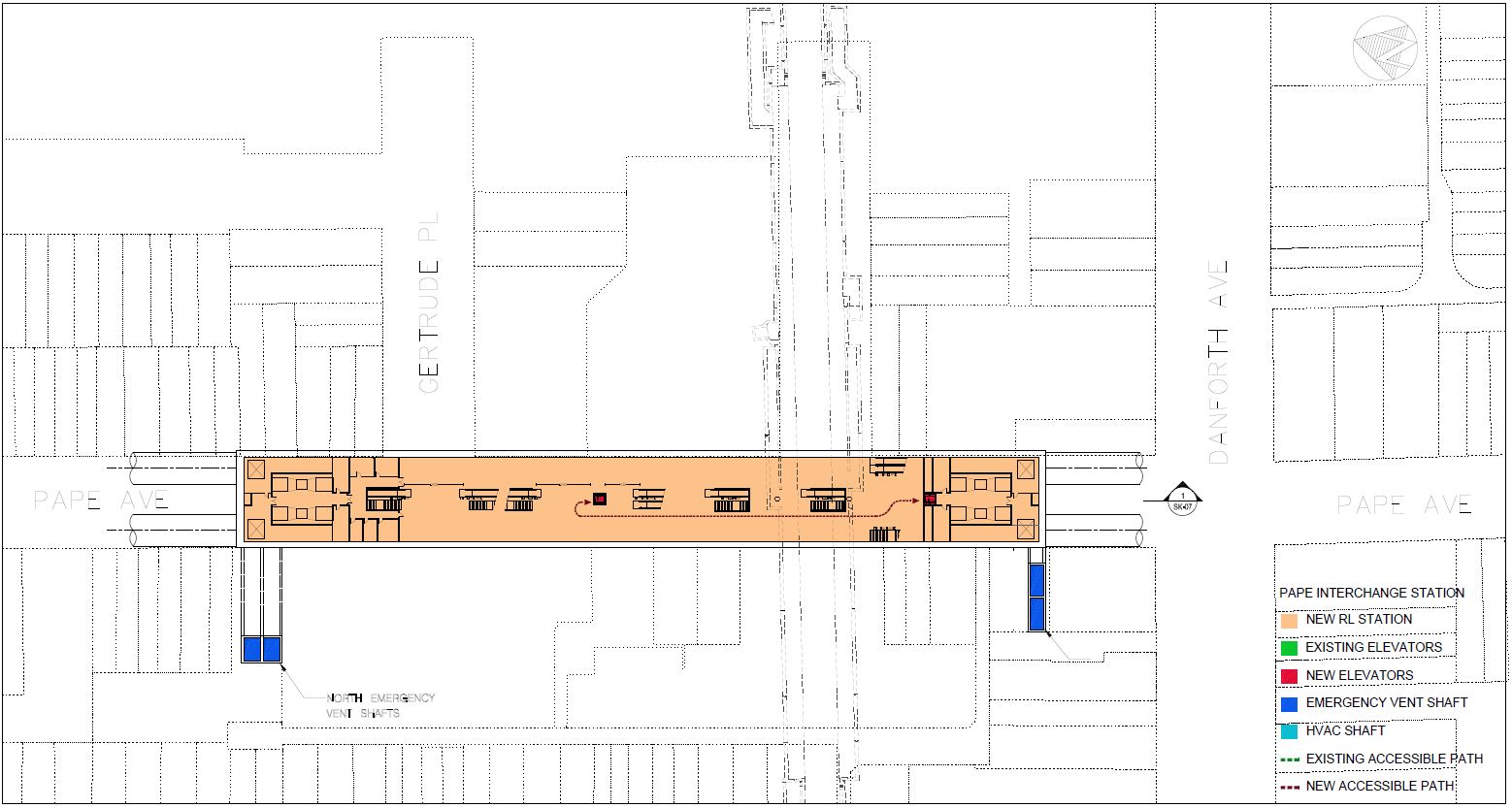
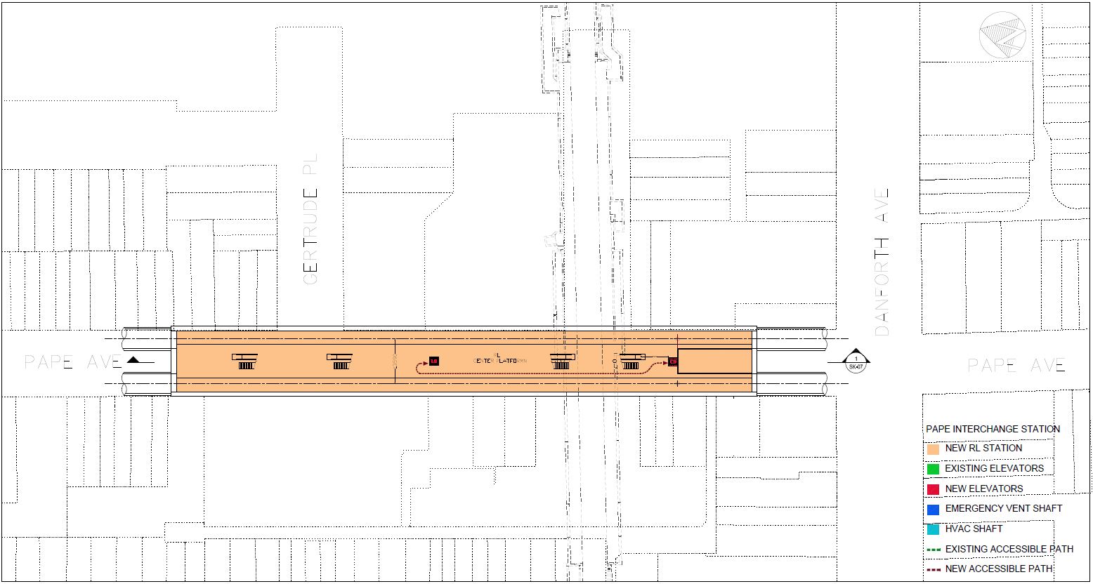
Pape Avenue and Station
North from Gerrard Station, the subway climbs on a continual grade toward Danforth, and breaks out above the bedrock which is quite deep here.
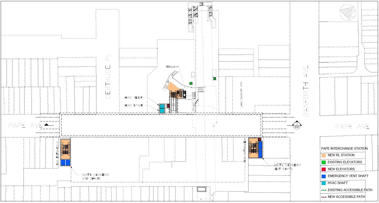
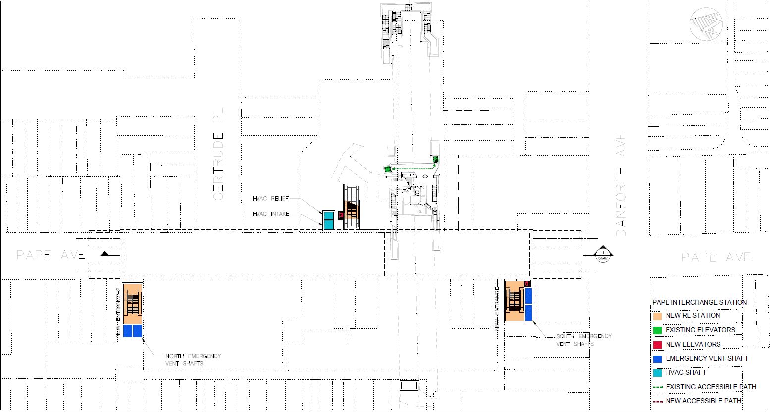
The interchange station at Pape and Danforth linking to Line 2 Bloor-Danforth is quite complex. As with the interchanges downtown, the path between the two routes is not as simple as at existing junctions. However, the new station’s design appears to focus more on the link to the existing subway (which is the raison d’etre of the RLS itself) than to the surface bus interchange whose importance would decline, eventually, when the Relief Line North replaces demand from surface bus routes.
New entrances will be provided on the west side of Pape both at the south end of the station near Danforth Avenue, and at the north end. The existing station will also see changes related to accessibility and a link into the new concourse structure. In the drawings below, note that north is at the left on the street level plan, but is at the right on the alignment plan immediately following.
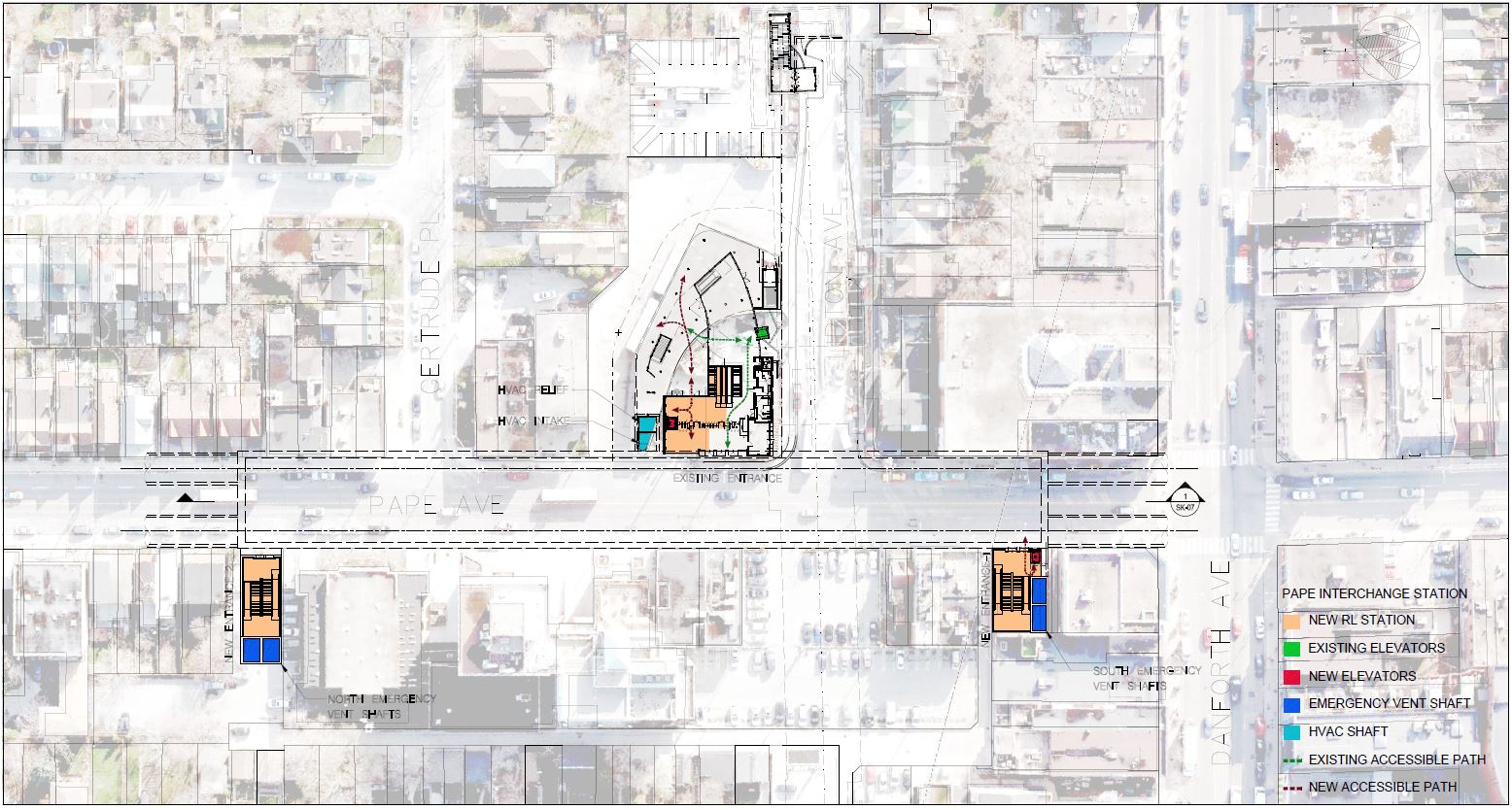
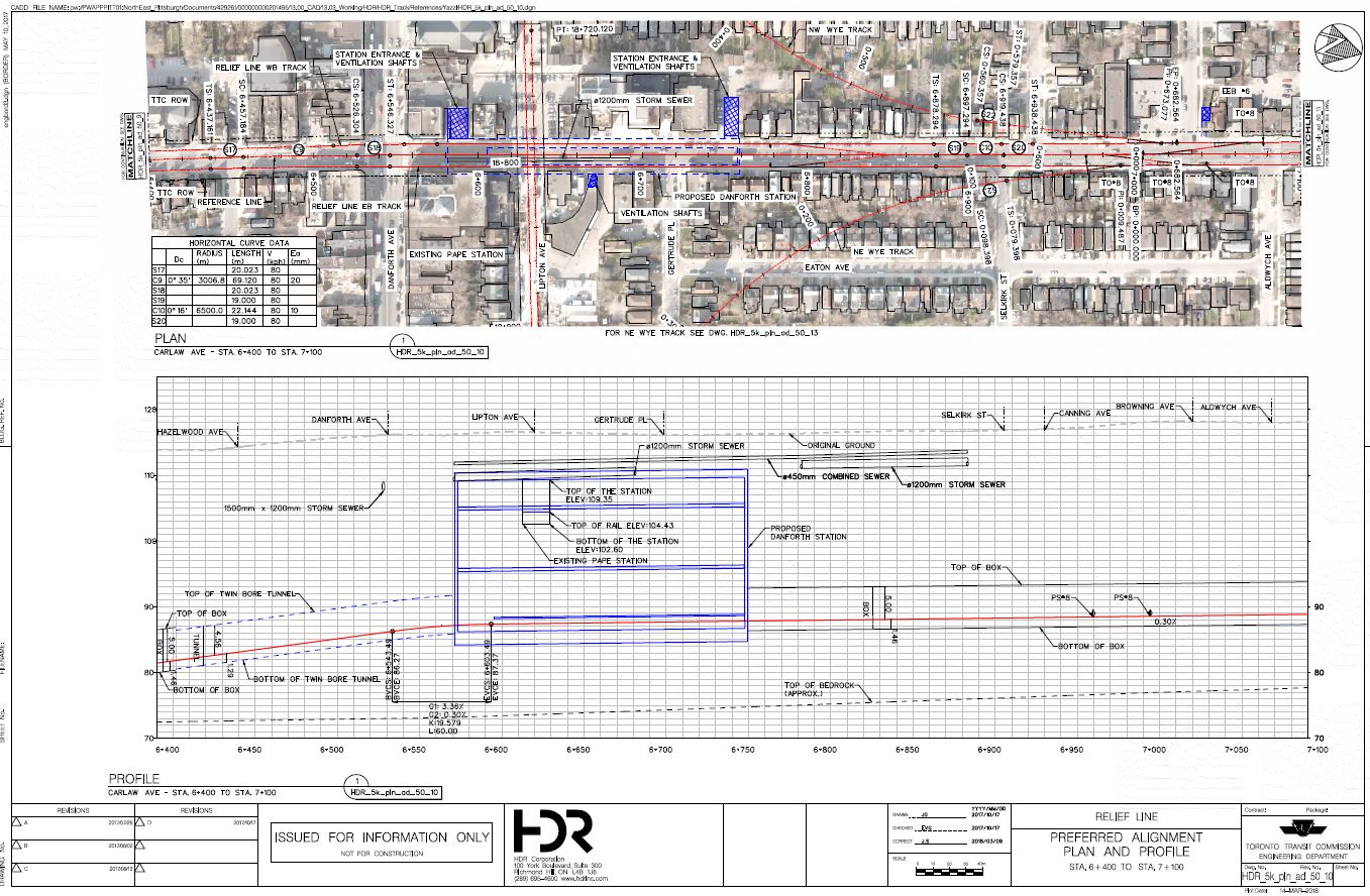
The comparative depths of the new subway and the existing Pape Station are quite clear in the cross-section below.
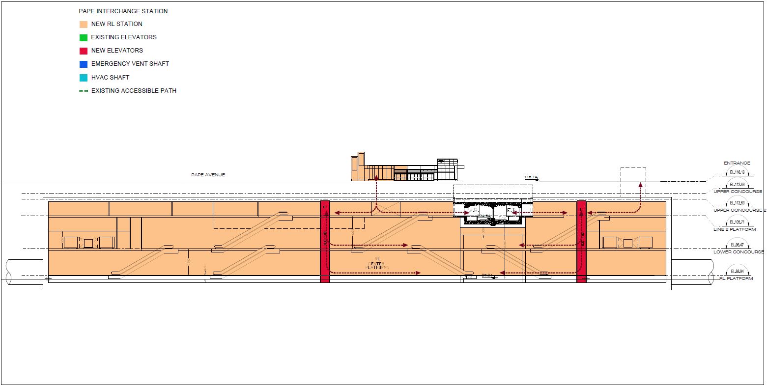
The first two levels down from the street include existing passageways from Pape Station entrance and bus loop down to the Danforth Subway.
At the level of the existing Danforth Subway, a new concourse will provide access to the platforms, and links up to new and future entrances as well as down to the RLS station’s mezzanine and platform.
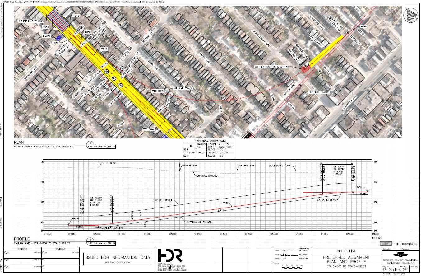
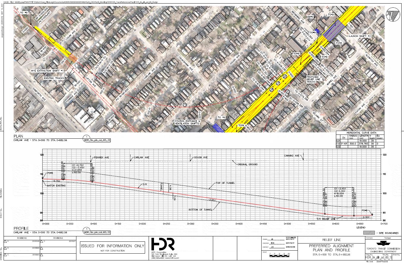
Pape Station Tail Tracks and Wye Junction
North of Pape Station the tunnel will continue far enough to accommodate a junction with the Danforth Subway and three storage tracks, two of which would become running tracks once the line is extended.
The link between the RLS and the Danforth subway is not intended for frequent traffic, but rather for occasional carhouse moves to and from Greenwood. There will be single track tunnels forming south-to-west and west-to-north curves. Because of the depth of the RLS structure, these links will have about a 3.5% grade.
The actual construction will be performed mostly using the Tunnel Boring Machines under existing buildings. For a short distance where the structure links into the existing Danforth Subway, the work will be done as cut-and-cover with these sites doubling as TBM extraction points. In the drawings below, the areas in yellow show the extent of excavation as opposed to tunnelling.

Incredible to see this finally take shape with real plans etched etched! I know there’s a long way to go but what a step to begin.
One thing I’ve been curious about through this whole thing is why there’s no stop at Parliament Street, or at least some kind of connection between Sumach station and Parliament. The 65 bus is so busy, and with that section of the neighbourhood up and coming just a bit it could be a huge benefit. I figured they could have accomplished this by shifting Sherbourne/Queen slightly west, so it’s more lined up between Sherbourne and Jarvis, then Parliament station with an east entrance at Sumach/King. I’m sure there’s a good reason I’m missing for the lack of a station at Parliament but I’m curious about it. Was it considered at all? Is it a matter of construction issues or ridership needs being greater with the Sumach station they settled on instead of the Parliament design in my head? Appreciate the insight as always, and thanks for all your tireless work Steve – don’t stop! We need you.
Steve: That Sumach Station is an oddball, but it is sandwiched into an area where there is some open space and an expendable older building that won’t be missed. Further west would be tricky given developments that are already in the works or underway.
A big problem with the Queen alignment (which itself is a product of SmartTrack, specifically avoiding having ST and anything else too close to each other) is that a Front Street alignment for the RL west of the river would have both lined up with Eastern Avenue and provided a better stop location. But for various reasons, mainly political, the line swings north to Queen.
A related issue in all of this is that had the line been built decades ago, it would not have to thread between a large amount of redevelopment that has been permitted with no thought to future rapid transit.
LikeLiked by 1 person
For the very deep stations, a strictly escalator approach seems a little strange to me. There is another approach to this, as Covent Garden and others in the London Underground have used with success: several large, fast elevators in a bank, as the primary route from street level to the platform level; Toronto’s Billy Bishop airport uses a similar approach. Covent Garden used to also have a somewhat claustrophobic spiral staircase for the fit and ambitious, but defaulting to elevators in the occasional station is clearly an acceptable approach to deep stations. That’s not to say the elevators could not be provided, but they could be fewer and farther away from the street-level entrance.
On a slightly separate note, it also seems a little strange to me that Dundas/Carlaw is not served by an entrance at the north end of the ‘Queen’ platform. Or, perhaps, the station could be more closely aligned to the mid-point between the two streets. That would at least provide a modicum of future-proofing for developments on those two streets.
Maybe there are engineering issues that constrain the above, but the plans do not seem to indicate that.
LikeLike
The splitting of Relief Line North and South conveniently kicks the can of confronting yard capacity needs down the road to the North project, leaving what amounts to a “Sheppard sized” remnant and avoiding a significant outlay. This is unfortunate as the North project already has a significant poison pill in the form of the valley crossing to Thorncliffe. The scope of RLS should at least be extended to Cosburn and its highrises and to intercept the cross-valley buses, but doubtless the arbitrary study zones preclude that and we will have a parade of buses down Pape sine die.
Steve: Until the line crosses the valley, the parade of buses will remain. I cannot see the TTC going to the expense and upheaval of creating a new terminal replacing Pape Station a bit further north.
LikeLike
Wow. Nice analysis, Steve.
Real live, engineering drawings of a future Downtown Relief Line. This might actually get built…
Looks like they’re going for standard “station box” construction – like TYSSE – not mined stations with an off street “box” for escalators and entrance like Crossrail or (planned) San Diego BART. Thoughts?
It’s going to cause lots of disruption in the downtown… Will make the (so called) drop in business on King Street/Bloor/St Clair look like child’s play.
With regards to future proofing – you mention 6 car trains, which is great news. However have they decided whether it will be “baby subway trains” or full size?
Steve: Not yet. They are also still debating unit trains like the TRs on Yonge versus married pairs. This affects fleet and carhouse flexibility. Greenwood cannot handle unit trains because of the shop layout.
I do wonder if the line will be built as driverless – like many of the new build Asian Metro lines and Grand Paris Express. Certainly would make the train storage easier – not needing space for operator break rooms and sign on etc.
Steve: The space for operator rooms is trivial compared to the overall structure. The RL would obviously be built with ATC signalling. Whether it would operate driverless is a matter for future labour negotiations.
With regards to Greenwood – so the yard won’t be used (post BD upgrade + new Kipling yard) as the Relief line yard after all? Or am I misreading.
Steve: It would be used for the RL, but the TTC would avoid moves to/from Greenwood as a regular part of service build-up/down especially during the shoulders of peaks when there is little or no spare capacity on BD to fit in the extra moves. Current thinking is that some trains would be stored on the line rather than going back to the yard as is done now on Sheppard.
LikeLike
Have there been any discussions of having triple platforms (Spanish Solution) at Pape Station?
Steve: Not that I know of. There is a space constraint under all of the streets in the older part of the city.
LikeLike
Thanks for this thorough post! If only this would have proceeded 30 years ago when there was discussion in the mid-80s about subway expansions. Do you know how this compares to what was initially proposed back then? I’m not finding information online and haven’t made a trek to the reference library or other archives to dig it up yet, so I’m going on what I remember of it.
Steve: Some info is in previous articles on this site here and here.
LikeLike
Maybe you have some info that we don’t have Steve, but do you have any idea on why these people are intent on creating bottleneck Bloor-Yonge style bottleneck stations at Queen/Osgoode and Queen/Yonge?
From what I can see, there’s really nothing preventing them from shifting the platforms to be centered with both the University Line and Yonge Line respectively, but yet they’ve gone with the worst positioning possible for both proposed interchange stations. I really don’t understand the logic, and it’s like the TTC/city planning is incapable of thinking anything through properly. The boneheaded decision has already been made to barely shift Eglinton station north on the Yonge line which is going to result in severe bottleneck transferring to/from the Crosstown line, and now they are repeating they same pathetic decision making on another 2 interchange stations.
Steve: First about Eglinton: There is a limit to how far the station can be shifted because of the curve where the Yonge line straightens out to run directly under the street.
As for the other stations, it’s likely a matter of construction constraints with a bit of politics thrown in. At Osgoode, building the station east from University puts more of it where they could encroach temporarily on the Osgoode Hall lands. Over at Bay/Yonge, I would not be surprised in the least that the desire to have an entrance at City Hall is responsible in part of the station’s location, even though the proposed City Hall entrance is woefully small for handling any major events at Nathan Phillips Square. There is also the issue of avoiding building the full station box under the existing subway rather than linking into the lower level where the “Queen Subway” underpass is today.
LikeLike
I am glad the Relief Line is advancing, and I hope it continues to do so after the next election.
But the Osgoode and “City Hall” stations need to be further apart. In fact, the Relief Line needs to continue one more stop west, but barring that, it would be better if the “City Hall” station were mostly east of Yonge, overlapping on its western end with Queen station on Line 1. University and Yonge are too close to have a station in between. This is especially true given the long walking distance to the next station, Sherbourne – only Osgoode and “City Hall” will serve the financial district, so they should be reasonably spaced.
LikeLike
I was at the Saturday presentation. They had a nice aerial photo of the route and the station locations, but not the detailed drawings Steve has in his article.
What happened to the single station at City Hall? I see no reason to build two stations so close together – save one station cost and spend some savings on beefing up the station/PATH connections. With the two proposed RLS stations in a “T” configuration rather than an “X” I have visions of Y/B transfer clogging. By building a single station at City Hall the transfer traffic would spread out and spending the savings (from not building that 2nd station) to improve the transfer circulation. Look passenger circulation at Bloor/Yonge and to a lesser extent St. George – can we learn nothing from past mistakes? And building at City Hall might be less disruptive to traffic flow in the core.
Queen/Sherbourne (Moss Park) makes me nervous. With the construction of every Subway in Toronto, the streetcar above has vanished. With four stations on Queen, would they kill off the middle of the Queen car and only save the ends? I would rough in the headwalls for a potential future station, and let demand build. The most expensive part of the line is the stations and I would like to see ridership numbers – this could be the Bessarion of the line. TTC claims that George Brown at King/Parliament will be a key source of ridership, but with the King and Cherry cars to link to Sumach station, who knows?
Sumach needs better design. This station currently looks like a cookie cutter station and the TTC is missing the potential of the location. First, move the location slightly to fit under the Duke/Duchess ramps – the ramps could be rebuilt to new as part of this process, allowing them to be redesigned to handle the traffic flow better when the DVP/Gardiner is re-aligned. Incorporate a streetcar track loop and bays similar to St Clair West – allow for King, Cherry, East Bayshore, Commissioners routes. TTC has been looking for a downtown east core loop, this could be it. With an underground, seamless link to streetcars this station becomes a key transfer link.
Broadview/Eastern (Sunlight Park) is still in floodplain territory and extra precautions to prevent flooding will add significant costs. Again I would rough in and build out as demand and floodplain remediation develop.
Would Carlaw station be improved with an underground link to the Queen car? Pedestrian tunnels to the south side of Queen, or dipping the track underground and pushing the complete station box south to fully encompass the Queen/Carlaw intersection? Would a bus terminal make sense?
Gerrard station again could use more tunnels/walkways to better link to the streetcar. At the meeting one of the TTC or HDR staff suggested that a streetcar loop at this station and running the Dundas car here as a new endpoint could make sense. They claimed that Broadview is too congested as it stands now and no room for improvement at Broadview exists. I think that with the additional ridership from the DRS a better solution could be to track Coxwell and terminate the Dundas car somewhere up near/at the station or the Queen/Coxwell loop. This would give more service options and give the DRN a link to the east.
Pape, as stated above needs to be built to handle both the cross flow and transfer of ridership – better than Yonge/Bloor please, and the turnback of trains. DRN is in the planning stages, and the life of Pape as an end of line station will be short lived, but build it right, as sometimes having the proper redundancy is nice.
My other issue with both the City Hall and Pape/Danforth stations is the single center platform design. I know that in the long term the goal is to extend north (DRN) and west (maybe not, as with GO RER, Smart Track, etc. the west side of the city is well served). However for the present time both locations will be end of track – and they will always remain the key line interchange points. I hope the stations can be built with either 2 track 3 platform or possibly with 3 track, 3 platforms. Build true end of line, turn back, add a train as needed stations. Toronto has 50+ years as operators of twin line subways, we should have learned all the issues by now, and TTC should have a list of things they would change if they could on the old system to make it work better – lets build a better mousetrap!
My other thought is boring. Holes that is! The design is for twin tunnels. I have also heard thoughts of a single big bore. This would be big enough to run the tunnels and build the stations, only adding vertical circulation. with the various mezzanines this is probably a bit optimistic. But if we go big, why not build 3 tracks? Having a north, a south, and a spare track would provide some options – main flow direction express service, spare track for weekend maintenance, extra train storage. Building the third tunnel as a bare hole for now would at least give options in the future, just track it in the future…Imagine having a 3rd track on the YUS as you add ATC no closures!
I asked the TTC staff on hand just what plans they had for streetcar access across the construction ROW, as both Leslie Barns and Russell Carhouse are to the east and the main trackage is to the west. I did not get a clear answer, though one fellow mentioned non-revenue trackage on Carlaw – this would seem to be a non-starter as there would be cut and cover construction on Carlaw. Another suggested that the Broadview extension and Commissioners trackage would suffice – again you run right through a construction zone. My thought is to build Commissioners and temporary/permanent track along beside the Martin Goodman trail to Parliament and then north to King. If built it by-passes all the construction. The track can be kept a non-revenue, or replaced by the East Bayshore in time. Whatever solution they use, so pre-planning needs to be done.
LikeLiked by 1 person
Thanks for the summary Steve. Can you describe the stage gates and project management milestones for this project? Has there been mention of the per cent completion of design? What is the ridership, cost and how much relief will this line provide? Isn’t it merely an expensive subway route to Pape station?
Steve: The stage gate info and project management have not been announced. We are not that far along. The TTC has $150 million from Queen’s Park to get the design to 30% and that is expected to be done sometime in late 2019.
Opinions on “relief” vary depending on which demand model one looks at. When Metrolinx reviewed downtown capacity in 2015, they showed a much greater effect if the line goes north to Sheppard. See Yonge Relief Network Study Technical Report.
LikeLike
Is it just me or are the interchange designs downtown and Gerrard just about the worst ones yet? To be perfectly honest, at the Danforth the entrance on the west side of Pape should have been done when they excavated for the secondary entrance building years ago.
LikeLike
This is a little disturbing, given the reality that ST is essentially a fiction, whose intent was to deal with the need for a relief line. The line should be optimized around assuming that GO will retain its primary function, without other services disrupting this longer distance commuting,
My normal reaction to subway in Toronto, has long been skeptical with the exception of this particular line. Having said that, one of the key considerations in my own mind, should be creating hugely improved future connectivity. To this end, I would really want to see this line extended as far as required to both intercept the Crosstown, and to get to the point where road rights of way are generally 2 chain beyond it. Don Mills north from Eglinton is 2 chain, essentially all major roads running east from Don Mills north of Eglinton, are 2 chain (132 feet). Thus a station at Don Mills and Eglinton, would also offer the possibility of being a transfer point for the Eglinton LRT in the longer term an anchor point of other services going forward. I would be concerned that ending the Relief line at Danforth, will simply mean that the issues on Yonge will continue to accumulate.
LikeLike
Since this is all going to take longer to construct than any present estimates; I wonder if a more eastern junction with BD might not work better in the second half of this century.
Like most of your readers, I’m very much opposed to the Scarborough Subway extension; but, I wonder if it might not look more sensible circa 2070 if the Relief Line ends up going east, instead of northeast.
Steve: Planning for 2070! There’s a job for you at Metrolinx who seem to justify things these days using extremely long timelines while failing to address present crises.
LikeLike
As far as the “too huge to make available online” files go, are they available and you downsized them for your site, or just not available at all to anyone? Viewing these things as non-vector “pictures” (jpegs) is a pain. Surely the originals could be provided as torrents, or is that too complex for City staff to learn?
Steve: The files are available from the City to anyone who asks (it says so on the project website). I downsized them as screenshots from much higher res originals so that general readers could view them here.
LikeLike
Putting Osgoode station’s HVAC inlet in the middle of University Avenue won’t do much for air quality inside 😦
LikeLike
Steve, I have this from an insider but I cannot disclose my name and email as he is on my Facebook friends list. There are plans to evaluate the ridership of the various streetcar lines once the DRL is up and running to evaluate whether conversion to buses makes sense. Also the 506 is expected to be permanently re-routed to Broadview once construction of the DRL starts which means that Main station will no longer be served by streetcars even post-construction (there are no plans to remove the tracks but it will happen whenever the roadway is constructed next). This is disappointing as I personally prefer streetcars over buses.
Steve: This does not make sense. There is little/no capacity at Broadview for another streetcar line and, as has been pointed out by others, one reason to reroute 505 Dundas to Gerrard Station would be to free up capacity for the Broadview car that will serve the Port Lands.
I have a lot of problems with “informed” insiders who are often shopping a blinkered view either of their own, or of whoever is their “source”.
In any event, I do not expect to see the DRL actually built for a very, very long time.
LikeLike
Thanks Steve, and commenters.
There’s no/zero question of not needing relief and better transit in/out of the core. It’s decades to a century overdue, especially on the east-west axis of the west/old core, left out again, but in terms of managing the car congestion and providing options to GO/King/Queen,G/L – vital.
But the priority for this Clowncil (aided and abetted by the province and feds) is squandering billions on a Suspect Subway Extension in Scarborough, which, if it gets built and if it brings in any new riders, (c 2500) to further overload the Danforth and B/Y, would be done at a cost of about $1.500,000 each person. The facts do NOT matter here, and the majority of politicians are deserving ousting on this issue, where they’ve clearly torqued process and facts. So bad is it, we shouldn’t have ANY trust and confidence in the processes I am sorry to say, and thus all the plans and schemes are tainted, even before the lottery of seeing what might be funded with changes in governments.
The province is especially stinky; this including a flawed EA process that looks at any type of subway as long as it’s here, and presumes there’s OK planning from the City, not so.
We may well be poised then to get – in 15 years?? – another stubway in the core, where it will not be adequate nor good enough value. If we charged cars appropriately, and had the $$$$ for effective transit, then it wouldn’t be such an issue. But given all the debts, do we need one more stubway with costly per-rider subsidies or real effective transit starting in three or five years is needed, which was the case at least a decade ago, correct?
The Brazilian city of Curitiba had political will and put in a system of surface priority routes with buses that gave them the same capacity as a subway for c. 1% of the cost, and it was done in a short time, relatively. And we really really need new corridors in Caronto, and also faster than milk runs, so I’ve been thinking surface first, to both save and speed up doing transit, in RoWs.
Steve: For the umpteenth time, I am tired of hearing about Curitiba when the roads into which the BRT system has been introduced have far more space than typical Toronto streets, and certainly far less left over for cars than any “right thinking” pol in Toronto would tolerate.
But that requires political will, and we’re caraven and carrupt. But why can’t we think of doing the Don Valley Parkway for faster transit? (Agnostic about form btw). And beside the DVP, we have the spur line owned by Metrolinx apparently that is unused, so there’s a LOT of surface and public land in an existing transport corridor that leads to the core, and to the north. Or it could, for a relative fraction of what a subway might be, and done much sooner, though no, it wouldn’t serve some core areas as well as this proposal might, but honestly, to the core from Pape etc. is really pretty bikeable and otherwise manageable, if it weren’t for the cars yes.
Steve: The Don Branch is only one track wide and it ends at the CP North Toronto subdivision at Leaside. If there is ever a Peterborough GO service, it might use this corridor, but I’m not holding my breath.
We could also do relief reversible busways on the roadways atop the subways eg. Danforth and Yonge St, with a cheap repainting, though merchants and many others would howl, but given the volumes of people jammed (and paying) to be sardines, why shouldn’t the great ##s of people also have a larger claim on the surface roadways than the privileged SoVs? And yes, with the Bloor/Danforth, we should also see a bikeway as a partial quick relief solution: London suggested a 10% realief on Victoria Embankment a few years ago,but the TTC ignores having bikeway relief because bikes are competition, and the money makes them interested in having the competition have suicycle conditions eg. Bloor St. E. between Church and Sherbourne in the 2001 Bike plan, but still not repainted for bike lanes for $25,000!!!
Steve: I look forward to your design that will provide both for bus roadways (including stopping/loading areas) and bike lanes while not completely closing the street to other traffic. Even on King, there continues to be local access.
As further eg. of how Forded up and carservative it all is and thus suspect, where is the Relief West? The DRL plan of 1985 had much the same outline of what’s now being worked on, and it too is in desperate need of relief, and the King RoW project is a token compared to what most other places would do ie. upgrade to a subway, This inferior assessment of King was in the 1993 WWLRT EA, which was a good document btw, second phase left undone perhaps as the first one was too good?
As there is some potential for the Main/Danforth GO/RER/TTC interchange to provide a fast and good surface link to the Union Station area, should we anticipate and expect this to be a reasonable bit of progress and ease pressures?
So for me there’s so much taint and suspicion around all of the schemes/planning/politricks, despite the good efforts of staff, we should be avoiding too much subway scheming in favour of really thinking surface options done quickly/cheaper to improve transit everywhere, and have some of the savings spent on APTA and UITP to take over and lead our transit planning. Along with a real development freeze, and no more thinking of any existing #1/2 extensions.
With what’s been suggested for this third of DRL, why is it so deep? Is it because we’ve wasted the chance to do things in earlier decades?
At times I think all this costly subway work is to make sure we bankrupt the system btw.
Going deep will be making the electricity costs soar, correct? I think #1 user of electricity in TO is the water, followed by TTC, and bringing so many up/down from great depths will be costly.
Going deep closer to the Lake will be making everything more prone to water infiltration right? Especially near the Don. Don’t we have enough leaks on the existing system eg. Spadina and Dupont etc. to be cautious?
Because we’re going so deep, we can’t think of bridging over the Don either. Is it political to make sure we’re deep for mass transit to avoid things like using the DVP for transit??
The alignment doesn’t go far enough to the NE When the Pape alignment began to emerge in the late 1940s I think it was for a subway, East York was hardly built-up and Scarborough was pretty much field. So to be far more reflective of current populations, we should be going far more to NE, and yes, that could bring us to the Gatineau Hydro corridor, which I think is the clear ‘fix’ for Scarborough, though in my mind we should put transit on this right away.
So as much as I like transit, and we need to boost it, for the climate crisis, the cash issues, and the transit issues of needing urgent relief, it’s somewhat of a cruel trick on the electorate to be bringing up expectations of relief, when it’s nowhere in sight, including on Yonge for another decade or more. We should bring in outside experts to remove the current scheming process and elevate it up to planning again, and get the planning people we do have working hard on what can be done in two or three months or years, and yes, be ‘roadical’. On-surface busways, perhaps reversible, and lets think of what new transit corridors are possible, like the DVP.
LikeLike
Planning for 2070 isn’t a philosophy; it’s a necessity, given the inchworms that govern and construct the GTA.
LikeLiked by 1 person
With the Curitiba reference, yes, the core roads are usually far too narrow – even for a cyclist. I like to cite Curitiba for the power of bus transit to provide higher capacity service, though often not as good as tracked transit. (Curitiba also had service provision innovations). Providing some reversible transitways to flow according to daily demands (with provision for returning to origin) should be thought about too, and this would be ‘roadical’, but shouldn’t our congestion crisis and liability for dangers of overload make us think of what is possible, quickly? The silos of the TTC and the City and politicians are all wonderfully isolated from any personal liability in case of death however, thanks to taxpayers, which is unfortunate. But if we were reacting to urgent issues, the width of the Danforth at about 16.5M is the place to begin, and with a reversible centre-lane busway from c. Victoria Park or Main to Parliament (then south), no stops. And yes to bike lanes too. (Bi-directional on N side c. 3.5M; W travel lane 3M; c 3.9M busway and off-peak delivery/parking; c 4.1 eastbound travel lane with extra width to let some cyclists go local and south; 24-hour on-street parking c 2m. The bi-directional lanes would be Sherbourne to Victoria Park; some extra care needed between Broadview and Pape. By leaving the curbs in situ this would be mostly cosmetic/signage/bollard stuff and could be done by c. July – if we felt there was any real congestion or climate crisis:) and yes, we could think of Bloor West, from Lansdowne to Spadina then south on RoW for other near-express bus services, and also Yonge south from perhaps St. Clair,though both these roads are really tight, so likely hard to get 1.5M bike lanes vs. wider curb lanes.
The real option for busways is likely with the excessways of the DVP and Gardiner/Lakeshore or some new construct aligned with a DRL/Front St. transitway, and I am thinking reversible. If the DVP is alleged to be too narrow, then that’s why I refer to that spur line beside the DVP (and one-track Half-Mile bridge by the brickworks, whose piers are still solid), There’s a fair amount of extra less-used width and space in this existing surface corridor and it makes sense to increase efficient usages for transit purposes correct? While I would expect that there are some examples of having a single-track bridge be signalled for two-way transit in many other places of the world, it also makes sense to be thinking of another way to get up to Thorncliffe Park and beyond ie. 2-chain Don Mills Road, and there’s some extra width on DVP at a curve and I’m sure there’s a way to get something done of benefit, and we have to make sure there are some construction jobs and concrete usage right?
Bus and busways are easier to put in, but I’m somewhat agnostic about what type of technology for surface relief and the where to enter core as well ie. could be near to Gerrard College for Ryerson/Hospitals/OCAD/UofT. As for the flooding issues, if we tackled the excess drainage problem with a tax on asphalt or storm sewer user fees, that would ease some of the Don River flood issues, but Mayor Tory isn’t interested in tackling that and alienating his base, though it could be a revenue stream as well as prevention.
As all of this doesn’t really do a damned thing for Yonge Relief until another couple of decades, maybe, thinking surface and sub-regional/fast is I think worth considering as a priority. It’s a bit annoying that there’s so much $$$$ for detailed planning (I thought it was federal), when we could get a three-for-one project for a few billion less far far sooner by thinking surface. The three are Yonge Relief by getting up to Don Mills Road via Thorncliffe; getting to the Gatineau and Eglinton as well; and that would be B/Y Realief too, And yes, Bloor/Danforth bikeway also – it’s been 25 years. There’s a West Relief needed too; almost more than some other zones as the bulk of the cars in the core that slow transit and endanger us seem to be coming in from that pinch point at base of High Park, but local politicians are quite OK with degrading the GO service to a relative milk run to make up for failing to provide the more robust transit, though they are usually outvoted by the suburbanites.
And meanwhile, the majority of the Clowncil are stifling the figures on the Squandering in the Scarborough area, including missing a final meeting over the summer, and despite the shovel-ready status of LRTs, nope, won’t go there, and if we go Fordwards, it’ll be backwards again.
LikeLike
The station placement at Yonge/University is awful… it looks vestigial from when City Planners were set on a single station at the “Psychological Heart” of Toronto at Nathan Philips Square. It looks like Planning changed their tune to care about transfers, just not enough to do it right.
There is only 300 metres from one station box to the other… then from there it’s almost 900 metres east to Sherbourne (or 800 metres west to Spadina.) This is bizarre stop spacing for the downtown section.
It’s also a disappointing missed opportunity that the new Pape station doesn’t have an entrance on to Danforth avenue.
LikeLike
I know it’s a side note, but can you comment or write an article on the Relief Line North corridor options? I’d love to see you break down each option as per it’s map before I make my comments and see if we think alike. I’m still stalling on sending the ttc my full blown opinion/analysis but they did get lots of sticky note comments at their consultation session.
Steve: It’s HotDocs season and I have less free time than usual. Also the RLN is not quite as pressing and so I will get to it in due course. My short take is that if they miss Thorncliffe Park because they’re afraid of the cost of bridges, then they really cannot call themselves planners.
Not sure if you have the materials, but for other readers there’s already a reddit thread going on using pictures from the consultation session in Thorncliffe Park.
Steve: I have electronic versions of the drawings and will post them in due course. I concentrated on RLS because I had far more detailed stuff than most people would be able to see at the public meetings.
LikeLike
Hamish: I always enjoy your ‘let’s try looking at THIS’ approach. We live in strange times when reformers and conservatives tend to say the same thing about the GTA transit future. Each group claims to have very different reasons, but the result is the same: nothing.
Having said that; you will need an axe and a few civil engineers to get buses or rail through the Half Mile Bridge [which Metrolinx owns, but doesn’t seem to know why] up to Loblaws in Leaside. Beyond that; good luck dealing with the CP [it doesn’t stand for civic pride].
Steve: I am always amazed at how much people who draw lines on maps don’t know about the details of where they propose to put new routes.
LikeLike
Metrolinx has a low priority to improve the Richmond Hill line. I am going to be bad and use my crayons … Suppose they cede the Richmond Hill ROW to TTC as far north as Oriole or Old Cummer? This leaves the south open for redevelopment.
Hamish may have a point with the Half Mile connection. With some work it could become a link in a LRT route from Laird or Don Mills on the Crosstown to a TBD location downtown. Faster to build than a subway. Keep the lower Don section raised on piers or berm to overcome flooding.
Use TTC track width and you could tie into the existing downtown core trackage at Gerrard.
Once the EC is open the congestion at Eglinton station will only get worse and the YUS line can’t take much more. Having an a fast (comparatively) to build eastern relief route with only a few stops to the core might be nice.
Running the line from Redway to Thorncliffe is straightforward. Choosing to head north to follow Leslie north to rejoin the RH ROW at Oriole could be as simple as paralleling CP lines, and using the old CN Leaside spur up to Lawrence or a separate link.
With a rebuilt connection/transfer point at Old Cummer, you would have Go heavy rail to the north, Leslie/Don Valley LRT to the south and Finch buses to the E/W.
If the DRN route selected was O’Connor/Vic Park, the Leslie/DV LRT would become a middle relief line in time and offer some redundancy. This would solve the Richmond Hill routes issues with flooding and electrification. Yes, the capacity is lower, but frequency is higher and a line that is a commuter only run to the core, becomes a more local line.
Steve: The Don Branch is only a single track line, and putting a double track LRT onto it, let along linking onto Gerrard, would be a challenge. The Leaside spur has been a bike path for many years, runs through a residential neighbourhood and has a level crossing with Lawrence just east of Leslie. I really get tired of correcting assumptions about the availability/suitability of routes.
LikeLike
If you think you’ve seen NIMBY you ain’t seen nothin’ like what would happen if Metrolinx tried to run actual trains up the former CP Don Branch. The last daily freight ran about ten years ago, and that’s all there was for at least the ten years before that, so everyone has got used to a nice quiet ravine with an “abandoned” rail line through it that’s used as a dog walking trail. Since that last freight, 60 houses on “estate” lots have been built, with the 20 on True Davidson Drive backing onto the rail line. To say nothing of the 20 or so long established houses on Douglas Crescent on the other side of the line. These are occupied by wealthy people strongly motivated to not ever have a train run on that line again, let alone frequent passenger service.
My bet is that it will turn into a rail trail park, just as the CP-CN connector track that ran parallel to Leslie Street behind the Inn on the Park from the CP North Toronto/Belleville sub to the CN Bala sub did. A few years ago the Evergreen Brickworks even had “artist’s impression” drawings showing it as a bike/walking trail with possible access to the Brickworks. How Metrolinx acquired it apparently without going through the official abandonment process, and with no requirement to actually run any trains is a mystery to me, but doubtless a railway lawyer could explain it all.
LikeLike
It is one thing to have residents oppose to development at town halls but when those homeowners are paid big bucks for their properties, the opposition winds down quickly. DRL is an exciting opportunity to change the character of eastern Riverdale and area from low rise to high rise. Density on and near subway lines is needed to curb the urban sprawl and preserve our green spaces. I work for one of the developers (though I can’t name which one here) and we are looking at bringing high rise condos to eastern Riverdale and nearby areas and it is only thanks to the DRL that we can do so. I am sure that other developers are looking for similar opportunities and it is high time that Downtown expands further east across the Don River.
LikeLike
With that Half Mile bridge, the supports are massive, although top portion of concrete is likely bad now from institutional ownership/neglect of the basics of water control, just like the City has been letting salty water infiltrate the seam of the Viaduct for many years now, preferring to have ma$$ive bills than simpler cheap sealant as maintenance (You can see this when one is on a bike, but not from having limited vision of the tunnel experience, or driving). These railway supports are also profiled to flare out a bit, so it should be possible to provide some form of wrap-around/bolted robust sheathing to provide a cantilever out with some form of internal (against concrete) membrane for differential movement with freeze-thaws so that a new deck and/or some form of enclosed track/road can be added atop it, after perhaps sheering off a meter with those concrete saws, not an axe, no. And it may be necessary to be building a new bridge/access from the southern point/area of this bridge up to Thorncliffe to ensure a safer operation as well as a loop, if it’s done in stages to provide a core-Thorncliffe Relief.
I also am contemplating sharing any RoW with GO buses. Getting on to a Gatineau RoW from the 401, doing the diagonal through Scarborough off-road to Eglinton/Thorncliffe to join up to a RoW to downtown. At some decade soon in this greenhouse century, we must combine GO bus with TTC sub-regional transit for faster options than existing choked corridors.
And yes, there’s seems like a fair bit of land to the south of the CP corridor, at least for a RoW.
And there’s also the Hydro corridor at some of the north end of Thorncliffe, and no, one doesn’t know all the details, but surface details are far more discernible in good time for better budgets than say, what’s under the Don River. And with a very long history of having surprises of hidden details of geology being costly for projects and sometimes lives, Keep it Simply Surface might be smarter and actually more practical. Even in Caronto/Moronto, at times we hear this. And what’s the proportion of large projects involving digging and tunnelling that go over budget?.
Meanwhile, in getting in to part of Ed Levy’s book there was a 1957 subway plan that showed a rather lengthy Queen St. subway all the way out to the 427 area. While I don’t think that Queen is necessarily the best option now, with the massive densities at King and ever-southward, plus the residential densities west on King etc., the length of this suggestion – maybe 18kms about 60 years ago – is almost deepressing; what a total Fail, of almost everyone, right? And so where’s Relief West? Or is the “plan” to degrade the regional GO service to a milk run? Since the core is pretty used to being screwed, it seems after a century of plans, the old City is still out of luck, now with an expanded ‘devilopment’ zone around a Smart Trick station despite it being a very limited access from Parkdale through an unpleasant and at-times fatal underpass as we don’t know why Peter Cram fell or was caused to fall off his bike, just as it’s not clear why a recent death on College, Robyn Craig was killed when he somehow fell off his bike and were the streetcar tracks to blame?
Steve: I really am fed up with the anti-streetcar comments from cyclists. The real problem is the limited road space and the lack of dedicated cycling lanes. Maybe we should ban parked cars because “dooring” is such a problem. This throwaway reference at the end of the comment has nothing to do with your overall argument.
LikeLike
Continuing OT (sorry) – on the “why did Metrolinx buy the Don Branch?” question, surely that was to run the Flaherty Flyer GO (or Via?) service out to Peterborough/Havelock? Without it, there’s no reasonable route from the Havelock line to Union Station. Certainly no politics here, cough, move along, etc. I suppose these days we could call it the Elliott Express…
I remember as a kid seeing Budd RDC cars going over the long bridge and idly wondering where they were going.
Steve: I believe that the purchase predates the Flaherty Flyer scheme as you call it, but Metrolinx was hedging its bets in case the CPR simply abandoned the line.
LikeLike
Steve – you’re right that it is limited road space, and also to some extent lack of dedicated bike lanes, and it isn’t necessarily related. Except: Bloor is still undone for safe cycling from the 1992 report and this is basically overnight relief; and streetscar tracks dictate lane positions on most other continuous east-west routes, and they’re dangerous to deadly, and nobody cares. And if we had Relief West as a priority, or something (and recently I’ve evolved thinking to put an idea of a Jarvis-style reversible transitway from pinch point at base of High Park to core via Liberty Village – somehow now that massive buildings seem de rigeur vs. any new transit to support this density) to enable safer cycling on perhaps Queen. Many of the streetscar tracks’ concrete adjacent to the tracks where the cyclist might get another foot in case of a door attack are also rubbled up to be another danger, and it’s a consistent problem, so “if you see something say something’ only applies to those who have paid fare, and let’s keep the bike competition really dangerous to keep the money flowing from captive TTC riders who aren’t on the suicycle side is the cynical/realistic line.
Please feel free to get a bike and try biking around yourself Steve, but you may be/are too precious a resource in many other ways, so don’t worry about it too much. I think a way to limit dangers can be to pull up on front handlebars to life front wheel over the groove, and of course there are apparently some solutions, but that costs money, and like second exits from some old stations, oh well, money’s tight this year…. and meanwhile over here is brand new plans for multi-billions, which only become effective with more billions and we don’t know how to pay for it yet as another small detail, and with billions in debt already….
Reverting to area at top of Half-Mile bridge in Leaside/Thorncliffe, I’m pretty sure I saw some mid-90s plan for transit using that rough area in an Official Plan document or something. If it emerges, I’ll try to share. It likely was a continuation of an idea to use the CPR line for transit after freight lines get bypass built eg. Missing Link as I think it may be called, and a better use of federal $$$ than some SSE.
LikeLike
This whole thing is ridiculous! Who is going to use it? Who is going to get off the Danforth subway to change to another train to downtown and then walk/ride to wherever they work? The big development projects are far away from it for the most part. The disruption tunneling under Queen St. etc. will make Eglinton look like a picnic.
A Relief Line into downtown needs to start far sooner than Pape station. It also needs to get people to where they work and do so in years not decades. Perhaps running south of Front/Esplanade, along Queens Quay? Easy to walk or ride northward towards office towers such as the massive ones under construction at Bay & Front and at old Lever Bros. (Unilever) site and even the massive Ashbridges Bay area.
Ease and speed of construction ought to be a priority in choosing the route of a Relief Line.
LikeLike
And astoundingly, the document I had a recollection of was at hand!! And in Appendix B of the Metro Official Plan there’s a line on a map through the Don Valley starting at the DVP/mouth and looking a lot like it gets up to Leaside Station and CPR line and then south of the line to link up to Eglinton. This is only a couple of dozen years old of course; not the same cachet as much else, and odds are quite high other tweakings are advisable, especially if one wanted to go really long through Scarborough on a very wide and less-used corridor eg. Gatineau. If we want to find some hundreds of millions for transit and housing and road repair, surely we must have a look at a set of options that provide some relief on three problems, but don’t consume billions that sometimes are in scarce supply. And isn’t the overload at B/Y and the main lines so acute that we must think of triage for it vs. a real fix? (which I don’t trust those involved in it all now to deliver as the SSE is still casting a long shadow).
Steve: The road you are talking about is the Leslie Street Extension that would have connected Leslie south and west to Bayview just south of the intersection of Nesbitt Drive where the CP North Toronto line crosses.
LikeLike
On the 6 o’clock news I saw that the Ontario government (ie. the Wynne Liberals) have signed a Memorandum of Understanding with Toronto, ie. with Mayor Tory, about transit funding. They are funding four projects in particular: Yonge subway north extension, Harbourfront East LRT, the downtown relief line subway (RLS), and SmartTrack to allow 6-10 minutes service. This is just a couple of days short of one month to the provincial election.
Well, great!
But, of course, Doug Ford has promised to review everything. Like a certain subway that was stopped and the tunnel filled in, hmmm?
Steve: And there is really little provincial “commitment” involved in the announcement. The MOU with Toronto deals with building new SmartTrack stations that Metrolinx will build, but Toronto will pay for. Still outstanding is the question of who pays for operation of the trains, and how the fare revenue and operating subsidies will be divvied up.
As for the DRL, North Yonge and Waterfront LRT lines, an “allocation” of funding from a pot that is notionally created by the budget is meaningless on two counts. First, there is a very good chance that the Liberals won’t be in any position to deliver, and the “allocation” does not bind future governments. Second, the Liberals have shown that their commitments can vanish in a puff of smoke when it suits them as we saw with Transit City.
It has been said before that a Queen Street alignment for the RLS (formerly DRL) is just political interference in proper planning. A route along Wellington allows for a subway yard west of Bathurst, whereas Queen St. is a dead-end.
It was mentioned that streetcars on Queen would remain. Though, during construction, temporary tracks on Adelaide and Richmond may be required. I am of the opinion that both Richmond and Adelaide should be restored to two-way traffic, and I would welcome the streetcars to return permanently, especially in light of the King Street pilot project. My friends in the area tell me that they all love the King St. project.
LikeLike
I just posted that maybe streetcars return to Richmond and Adelaide Streets. It would offset some of the King Street commuter volume, and cover for the Queen Street subway construction. However, I got to thinking, it might not make sense to run Bombardier Flexities along these routes.
I have said before that there seems to be a preoccupation with putting out the largest possible vehicles on the routes. Is it really better to carry 60 passengers every 30 minutes vs. 20 passengers every 10 minutes?
In many places in Europe, mini-buses start their routes as soon as they are full, no schedule. And they will drop off off-route, too.
I urge the TTC to retain a good fleet of CLRV’s, because the Flexities are too big for some routes. I realise that there is the issue of vehicles being accessible, but, as a walking disabled person myself, the idea is good but it is also over-kill. There ought to be some compromise.
Steve: The CLRVs are well beyond their design lives and the real question would be whether the TTC should have more, shorter cars to improve headways. This is not practical on King where the constraint on capacity is that the route is close to the maximum number of cars/hour that can operate on the street. Higher capacity comes from larger cars, or from trains as we saw years ago on Bloor-Danforth before the subway opened.
Today on King, the 514 Cherry cars and about one third of the 504 King cars operate with Flexitys with a combined service of roughly 25 cars/hour during the peak (this varies from day to day). By late 2018 when all of the cars are Flexitys, the capacity of the route will be higher, and this can be further increased by running 30 cars/hour. Beyond that level the frequency of streetcars and the cycle time of traffic signals interfere with each other. The combined effect of larger cars and more cars would be an increase of design capacity from about 2,500 per hour today to around 4,000.
LikeLike
I wonder if these really deep TBM tunnels were chosen to save money or because the project has been delayed so long that it’s the only way to still build the tunnels in a timely manner. I’m not a civil engineer, I don’t know the soil conditions in Toronto, and I don’t know what else Toronto has down there, but Ottawa saved a lot of money on its tunnel by raising it and building it with a slower NATM mining approach rather than a TBM. Having a tunnel under the Don River sounds really expensive too. Needing to climb five stories to exit a station sounds like something more appropriate for a commuter train than a subway.
@Andrew Clarkson:
I’m personally really worried about what will happen if the DRL ever extends west because it will immediately ruin whatever is there. People in a condo building worth hundreds of millions of dollars don’t like it when there’s a tattoo parlor, a zipper seller, and a condom store at the bottom.
LikeLike
Hamish: As a cyclist I am really unclear as to why you’re blaming transit for anything. Cycling in Toronto sucks. The overwhelming causes are as follows: 1) political culture which holds it as unacceptable to take any road space anywhere away from private vehicles; 1b) the previous point coupled with historical reality of Toronto streets being narrow; 2) political culture which favours big-bang project announcements (“world-class”) over smaller projects. Were streetcar tracks to blame for cyclist deaths? No, the causes were impotent politics and the society not giving a fuck. You might as well argue lack of a fence is the cause of deaths of schoolchildren.
LikeLike
Just an observation of a general nature, but i have seen these sort of words from a number of different people (I am not attributing it, as my intent is not to argue with an individual) :
As one who has spent the better part of the last year and a half on a project involving London Underground, it fascinates me the way some in Toronto love to cite things about LU as the way we should be here in Toronto, usually with only a narrow scope of knowledge about LU specifically, or TfL or even Greater London in general.
In the case of some of the proposed designs for the relief line, the opposite is coming through in some cases. Needing to climb five stories to exit a station, or close to that same climb to change trains, is an every-day occurrence in London. In some cases, the climb to change trains with interchanges that look good on the non-geographically-correct LU map mean that some interchanges are comparable to changing between Line 1 and Line 2 with a walk between the platforms of Bay and Rosedale! Ever want to know what it feels like to find your way through a rabbit warren or an ant colony? Spend a day or two on LU.
I’m not saying that either our subway or LU is better than the other. There are some things better there, and there are some things that are better here. While it would be nice to cherry pick all the great things of both, every so often a great-to-have feature come with a not-so-nice-to-have.
LikeLike
In response to Jarek and perhaps Steve about cycling and streetcar tracks: they’re hazarous and absolutely can be lethal, and while sure we like transit, and it’s needed, not only do these tracks present ongoing ever-present hazards on the main roads in the old core that we use (moreso as the road grid isn’t consistent to provide longer-haul east-west), they also dictate the lane positions because it’s not possible to re-paint the lane lines overnight, like Bloor could and should be. The City and TTC are avoiding including the track crashes in their stats as well though it’s a very real set of costs/harms.
Citylab article
And if one does bike along many of these east-west core roads with tracks there are numerous sections where the adjacent/holding concrete is really broken and creates even more hazard. The dominant city culture is for private cars yes, and the roads are narrow, yes, and sometimes cyclists do present hazards to others, but safe/smooth/straight bike routes would do a lot to ease crowdings on transit in the core areas, which the institutions tend not to want as the core supports suburban services.
I’m glad some are seeing some potential in a surface-oriented relief option, and I’m assuming we have larger sums and some ingenuity to overcome issues, which will exist. With the NIMBY of some residents, while it will be real, the realities of overload involve far too many thousands of others, and if we could save some billions, that’s all in the public interest so too bad, and we do have some powers of expropriation sometimes.though it’s a heavy tool.
As a definite cyclist (usually) the higher/best use of some of these corridors, including some of the Rail Trail (some conditions needed), is for better transit, and I’m a skunk within parts of cycling groups for saying so.
Steve: I really do get tired of an old study that misrepresents the real level of danger getting cited over and over, especially second hand through a Citylab article. Yes, there are issues with pavement maintenance, although this is an issue on many streetcar-free streets too. But maybe we could just get rid of the streetcars and let you compete with the far more numerous and unpredictable buses that would replace them as on Dundas and College these days.
LikeLike
At a social event of the Ward 30/36 bike cell, Michael asked who had fallen on the tracks, and everyone put their hand up. The potholes are one thing btw; the long crevices aligned with the direction of travel are something else. And of course most cyclists like transit, but the practice can be less OK, and that now includes having buses on College. At this point, 60 years after a good plan had a Queen subway out to the 427 area, cyclists should have some clear E/W trip options through the old core, not merely the patchwork/notwork we have now.
And for buses, while not convinced they’re as ‘green’ as all that: CityLab: Five Breakthroughs That Could Make You Love The Bus.
Steve: The quality of pavement adjacent to the streetcar lanes is an ongoing problem, but it’s more the city’s fault for failing to maintain the road properly. As for the future of buses, that article is a rather rose-coloured view of things. I am not seeing moves by LRT/streetcar systems all over the world to abandon their systems.
Also of course electrification is a double-edged sword depending on where the power comes from. It amuses me greatly to hear critics of rail transit carp about dirty peak power without wondering where all of the power to run fleets of electric buses will come from. There was an interesting observation in the Metrolinx hydrogen train study where it was claimed that there is not enough spare overnight power to generate the hydrogen they would need, especially if the grid gains a major new overnight load to charge autos and the like.
LikeLike
When it comes to transit planning, a Doug Ford led PC government in Ontario might not be an unmitigated disaster after all.
I was listening to the news on the car radio yesterday evening. They said that the opinion polls show an unwavering 42% support for the PC’s, while the NDP are in second place, Liberals third, Greens barely register. That means a PC majority at Queen’s Park.
Furthermore, regarding transit, the radio said that Doug Ford intends that the province take over Toronto’s subway system (we have heard this before from the Liberal-controlled Metrolinx), and that Ford wants “to go back to an earlier version of a multi-stop Scarborough Subway Extension”.
Hmmm, I thought. The TTC has been successfully building and operating the subway for 65 years. Why fix what ain’t broke?
What is indeed broken is transit planning in Toronto, which is controlled by city council:
– Relief Line, planned along Queen Street for a showcase City Hall station, not Wellington, where it makes much, much more sense. The King streetcar already carries a passenger load worthy of a subway.
– Relief Line, truncated at Danforth, not connected to Eglinton Crosstown.
– SRT, was offered by Queen’s Park to be replaced by LRT, at no cost to Toronto, yet council turned it down.
– Toronto unable to build LRT in Scarborough
– one stop $5 billion SSE, a politicized boondoggle.
– Mayor John Tory’s pet project, the SmartTrack
Now it makes sense – take out one of the players that cannot pay for what it plans.
We see the same problem with Hamilton and Brampton city councils, neither can figure out LRT planning for themselves.
Municipal councillors are no transit experts, after all.
Most importantly, it leaves Toronto council free to concentrate on housing.
Steve: Queen’s Park has been complicit in much of what you list here as “city” problems:
– SmartTrack has been supported as a concept to keep John Tory onside, and because its underlying purpose was originally to serve Markham and the Airport commercial area in Mississauga.
– The Queen Street DRL alignment is also to keep it well away from “competing” with SmartTrack and to leave space under Front/Wellington for a GO Transit tunnel.
– The Scarborough Subway was actively supported by the Liberals as a way to appear “pro Scarborough”, and there has been less than full-blooded support for an LRT network.
– The Relief Line was not considered to be anyone’s problem until its absence threatened the viability of a Richmond Hill subway project, another provincial sop to York Region.
– The subway to Vaughan is a direct result of Queen’s Park getting into bed with York Region and with property developers who stand to benefit from the subway.
Many of our problems for the past decades arose from Queen’s Park’s meddling in Toronto’s transit, and a takeover by them from Toronto will not change this.
LikeLike
Steve, I very much appreciate your at-length replies to my comments, thank you!
I absolutely agree, Queen’s Park has been meddling in Toronto’s transit. You have pointed out many times about the SRT not being an LRT in the first place. Probably many examples prior to that.
And, Queen’s Park meddles into other municipal affairs. Examples, Mike Harris downloaded public housing onto the municipalities, and last year, QP shot down tolls on the Gardiner Expressway. But, QP can do this any time they want, because municipalities are wards of the province. Further, Toronto amalgamation, creation of the Regions of Peel, Durham, York, etc., and the laws that govern what taxation rights the municipalities have, greenbelts, highways, accesibilty law …
Indeed, I am rather disgusted in the political meddling by the Liberals in transit. GO, a provincial agency, cannot properly plan their bus routes. GO is playing some kind of game by not making connections to Pearson Airport, trying to force everyone to take their UPX. When it comes to public transit (and Hydro), the Liberals deserve a big “FAIL”.
I have been following the SSE thing from the beginning. I am rather thinking that if Toronto city council had no say in it in the first place, there would be no discussion of it either, and the Liberals would not have had to play the game.
Same thing about Mayor John Tory’s SmartTrack, that if Toronto city council had no say in it in the first place, there would be no discussion of it either.
SmartTrack is just screwing up proper transit planning. It sounds good on a serviette and it wins votes.
So, I need to ask, what is this transit tunnel under Front/Wellington that Metrolinx/GO is planning? I have never heard of it.
Steve: This was one of the alternative routes to expand Union’s capacity, and was one of the more hare-brained schemes for SmartTrack.
LikeLike
In regards to the Greenwood yard connection, it would be more feasible to run it north of Gerrard stn, on a north to east curve parallel to the Kingston sub, on the north side, rising to level east of Jones Ave, just prior to arriving onto the Greenwood yard turnaround track. By my estimation some properties close to the Kingston sub would have to be expropriated for this to happen. Your thoughts?
Steve: There are a few problems with this scheme as I have learned while finding out why it was rejected.
First, Gerrard Station is quite deep, and the station box lies entirely north of the rail corridor. Any spur that would follow the corridor would have to split off south of the station closer to the Carlaw/Gerrard intersection. A spur north of the station would have to travel a fair way south just to rejoin the rail corridor, and would involve a greater curve because of the alignment of the tunnel.
The next problem is getting up to grade. It’s a fair climb from the depth of Gerrard Station up to surface level at Greenwood, and the last part of the climb has to be done east of Jones Avenue because one must get under the street. Part of this link necessarily must be built cut-and-cover in and adjacent to an increasingly crowded railway corridor. Back before GO started adding tracks here, this might have been feasible, the the railway expansion is already underway and will finish long before any work would be done on the RL. One could argue “do it all at once”, but with the RL still only a hoped-for line when GO expansion is essential to RER and SmartTrack, this isn’t going to happen.
Please refer to the alignment diagram I published in a previous article.
LikeLike