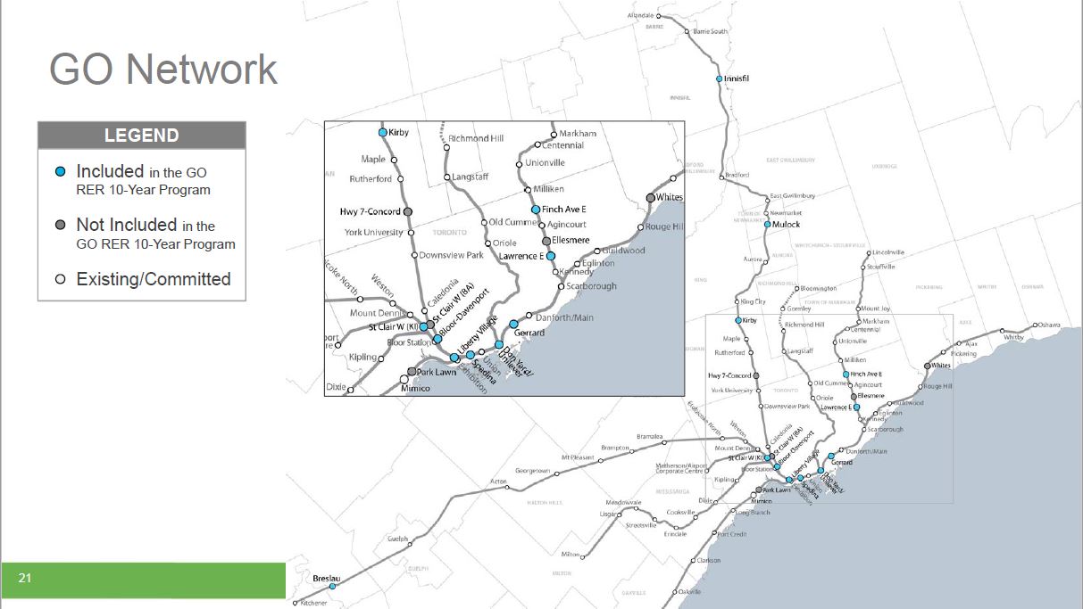
On March 16, 2017, Metrolinx released a series of studies dating from July 2016 containing the “Initial Business Case” reviews of proposed new GO Transit stations. The list came from an earlier process in which Metrolinx began with every conceivable location for new stations on the planned Regional Express Rail (RER) network and winnowed this down to those that were, broadly speaking, workable. The New Stations Analysis from June 2016 explains this process and the outcome, the choice of whether a station is “in” or “out” of the network, is summarized in the following map:

I asked Metrolinx why the detailed reports on each station were only released now rather than concurrently with the Board report.
Q: … the station analysis reports were only released [March 16, 2017] although they are dated July 2016. Moreover, the Board considered a report on this subject in June 2016 but the detailed reports have not been summarized nor presented to the Board publicly at this or any following meetings. Why has it taken so long for these reports to be published?
A: Upon approval from the Board last June, we engaged with our municipal partners and other stakeholders to finalize the documents. Metrolinx requested formal confirmation of funding from municipalities by November 30, 2016. Once that was received, we worked to get the business cases posted as soon as we could.
If one reads only the summary report presented to the Metrolinx Board, one might have the impression that many of these stations show a positive benefit for the network. However, the detailed reports tell a different story and beg the question of how Metrolinx planning staff got from the business cases to the conclusions in the Board report.
The posted reports are dated over six months ago, and their date does not reflect more recent work, if any, with “municipal partners and other stakeholders”. Whether this is only an editorial oversight, the basic issue is that the case made in the station analyses is not as rosy as the one presented in the summary report to the Board.
A key issue here is that many of the stations form part of Mayor Tory’s SmartTrack plan, and a Metrolinx report throwing cold water on their effectiveness would run contrary to the claims made for SmartTrack’s potential. One might ask whether the Board was misled about the potential harm the SmartTrack stations could bring to GO/RER’s goals.
As reported in both the Globe & Mail and the Star, many of the new stations are projected to have a negative effect on the network. The analyses can be summarized in a few points:
- Any new station adds travel time to a GO Transit corridor.
- Demand models are sensitive to travel time, and they predict a loss of ridership if trips are slower.
- New stations could bring new riders, but these are not necessarily sufficient to offset the loss of longer trips which are the raison d’être of the GO network.
- New riders from stations close to Union make shorter trips at lower fares leading to a net revenue loss even without considering the SmartTrack proposal to charge “TTC fares” for travel within Toronto.
- The loss of longer trips drives up the modelled use of autos for commuting compared to what would have happened without these stations. This has a compound effect through the business case analysis because many factors depend on reduced auto mileage.
There are three fundamental issues here. First is the problem of repurposing the regional GO/RER network to provide local service within Toronto. Although SmartTrack as proposed in John Tory’s election campaign included very frequent service, what is actually to be implemented is considerably less ambitious thanks to constraints (both physical and financial) on GO’s investment in additional capacity. Planned peak period services are:
- Stouffville (Scarborough) corridor: 7 trains/hour with an average headway of 8.6 minutes
- Kitchener (Weston) corridor: 6 trains/hour with an average headway of 10 minutes
- Lake Shore East corridor: 11 trains/hour with an average headway of 5.5 minutes
The only corridor to receive service at the level foreseen for SmartTrack is the Lake Shore, and this is applicable only to stations from Danforth (at Main) to Don (at or near the Great Gulf East Harbour development). This higher service level results from the combination of trains on both the Lake Shore East and Stouffville corridors serving these stations. Any new ridership due to SmartTrack has to fit within capacity planned for GO/RER.
Second is a problem of assumptions in the modelling. In all cases, a new station is seen as slowing down GO service, but a major benefit cited for GO/RER electrification is the ability to serve more stations with no increase in trip times over diesel operations. The business case models assume a 1.8 minute delay for each additional stop, and this translates to ridership loses for the long-haul travellers whose trips are affected. However, this analysis does not take into account the possibility that new, electrified service would be implemented concurrently with the new stations thereby eliminating the delays.
Depending on the corridor and the degree of electrification, some trains could remain with diesel power, typically those running to the outer ends of routes beyond electric territory. These long trips would suffer more delay than the shorter electric-propelled ones. However, if the diesel trains run “express” past some or all of the new stations, the resulting service levels will be less attractive to riders, and the wait for a train to Union from an inside-Toronto station would be a substantial portion of the total trip.
I asked whether electrification had been taken into account:
Q: In the studies, there is a reference to the extra time needed to serve a new station on the line, and in the case of Lawrence East this adds 5% to the upstream travel time. Has this number been adjusted to reflect operating characteristics of electric trains? One important point in the electrification study was that these trains could sustain more stations with the same running times as existing diesel trains having fewer stops.
A: Electrified vehicles were assumed in the calculation of delay time.
This does not address the issue that if stations are added concurrently with electrification, there may be no change in travel time and still possibly a net improvement.
Also:
Q: For corridors with multiple proposed new stops, there is the question of the cumulative upstream effects which, I suspect, are not additive.
A: The business cases analysed stations individually and independently. Effects of adding multiple stations to a line would be cumulative, creating trade-offs between end-to-end trip time and the journey time of individuals taking advantage of new stations. This limited the total number of stations that could reasonably be added to a corridor.
That last comment is telling in that it effectively says there is a point where making a route more “local” is counterproductive. This is no surprise, except possibly to SmartTrack advocates.
A related issue acknowledged in the studies, but apparently not in the modelling, is that other factors will influence the choice between driving and taking a GO train – increased road congestion, the difficulty of obtaining parking at one’s destination, and a reduction in car ownership levels over coming decades. A large component of the negative analysis for some stations arises from a ridership loss than may not materialize.
The third problem is the proposed “TTC fare” on SmartTrack services, and the parallel efforts by Metrolinx to change the TTC fare structure for “rapid transit” services to more closely match its own fare-by-distance model. Demand studies for the Scarborough transit network have shown that a TTC fare (defined as the current flat fare with free transfers between routes) combined with very frequent service (12 trains/hour) contribute substantially to potential ridership for SmartTrack. Without these, less demand migrates from the TTC network to GO/RER.
To put these issues another way, there is little point in adding stations to the GO network if the combination of location, service level and fare attracts little ridership inside Toronto, while extra travel time for trips originating outside of Toronto drives riders back to their cars. That said, I believe that the unattractiveness of GO as an alternative to TTC would be a more serious effect than the anticipated ridership loses because other factors would affect a decision by long-trip commuters to move away from GO.
Indeed, if capacity on GO services were compromised with large volumes of short-distance riders, this could be as much of a deterrent to GO ridership as the extra time spent at inside-Toronto stations. The Business Case reports do not address network capacity issues because they review each station proposal in isolation except where station catchment areas overlap.
Almost all recent controversy between Toronto and Queen’s Park centres on capital subsidies for a number of projects, and operating costs are left for another day. However, the position of GO and SmartTrack in the network is intimately linked to operating costs as this will affect the sharing of incremental expenses for new station operation, pressures for additional capacity and service, and fare subsidies by Toronto to bring GO fares down to “TTC” levels.
The current studies do not address the relationship of SmartTrack to existing GO stations and the question of whether “TTC fares” will be available at Milliken, Agincourt, Kennedy, Danforth, Bloor, Weston and Etobicoke North stations, let alone stations on other GO corridors within Toronto. Why should a rider from a SmartTrack station travel downtown for a “TTC fare” while those at Rouge Hill, Cummer, York University, Kipling or Long Branch be forced to pay on the GO Transit tariff?
How much is Toronto, a city that refuses to properly fund its own transit system, prepared to subsidize travel on the GO network within its boundaries?
Station Reviews
The following sections review each of the proposed stations on the GO network as presented by the corresponding Interim Business Case report, grouped by corridor.
Toronto Council has agreed to fund eight stations, six of which lie on the “SmartTrack” corridor from Scarborough (Stouffville line) through Union Station to Weston. Two stations are part of the Barrie corridor.
Several scenarios were used to evaluate the stations, although not all options were considered in each case because local circumstances ruled them out.
Beyond the question of demand models and potential for ridership gains or loses discussed above, other factors appear commonly through these station reviews. Notable among them is the difficulty of attracting new riders to stations on the rail corridors within Toronto. These lines tend to lie in industrial districts well away from major residential or job markets. They are dependent on walk-in trade, to the extent that any exists, as well as connections from TTC routes. Unlike the typical 905-area GO station, the new sites within Toronto will not be surrounded by acres of parking and cannot depend on park-and-ride as their primary source of traffic. This makes the combination of service frequency, speed and fares even more important if GO/RER is to provide a credible alternative to or supplement of the TTC network.
A recurring problem with the reports is that selective data such as daily gains or loses of riders are sprinkled in the text, but the consolidated numbers are given only for a 60-year evaluation period. Where changes are reported, they are not given in context relative to the base numbers of projected riders, nor, as mentioned earlier, with any reference to the available capacity on each corridor. All of the financial effects (hard and soft) flow from these ridership numbers, but it is unclear how they were derived or how alternate assumptions might affect them. To avoid repetition, I will not mention this for each study, but statements regarding ridership, revenues and costs should be treated with caution.
I have asked Metrolinx for additional data on existing and projected demands so that these can be compared with the effects reported from the station modelling exercises. I will add this information when it is available.
Finally, there is an odd viewpoint about what constitutes a “nearby” station in several of the studies where the distance from a potential station to residential density is seen through the eyes of a suburban driver, not as by a city resident who measures trips in blocks, not kilometres. This is especially troubling when access to a station would require going out of one’s way or a difficult walk where where local geography interferes with a “crow fly” access path.
This article deals with stations in the Stouffville and Weston corridors. In a second installment I will turn to the Barrie and Lake Shore corridors.
Continue reading →