King Street Transit Priority Corridor Update: May 2024

Toronto’s Infrastructure and Environment Committee will consider a report at its May 2, 2024 meeting which updates Council on the status of the King Street corridor.

A notable shortcoming in the report is the absence of a map showing locations of proposed or completed works, and how King Street relates to other nearby sites where roads have limited capacity or are completely blocked.

As previously reported, the City implemented new measures late in 2023 to resolve traffic gridlock at several intersections along the corridor between Bathurst and Jarvis streets. Many overlapping construction projects reduced road capacity and caused severe backlogs on King Street rendering transit service, especially eastbound, almost worthless. Charts later in this article update my previous reports on the situation and how travel times on King have returned to preconstruction levels.

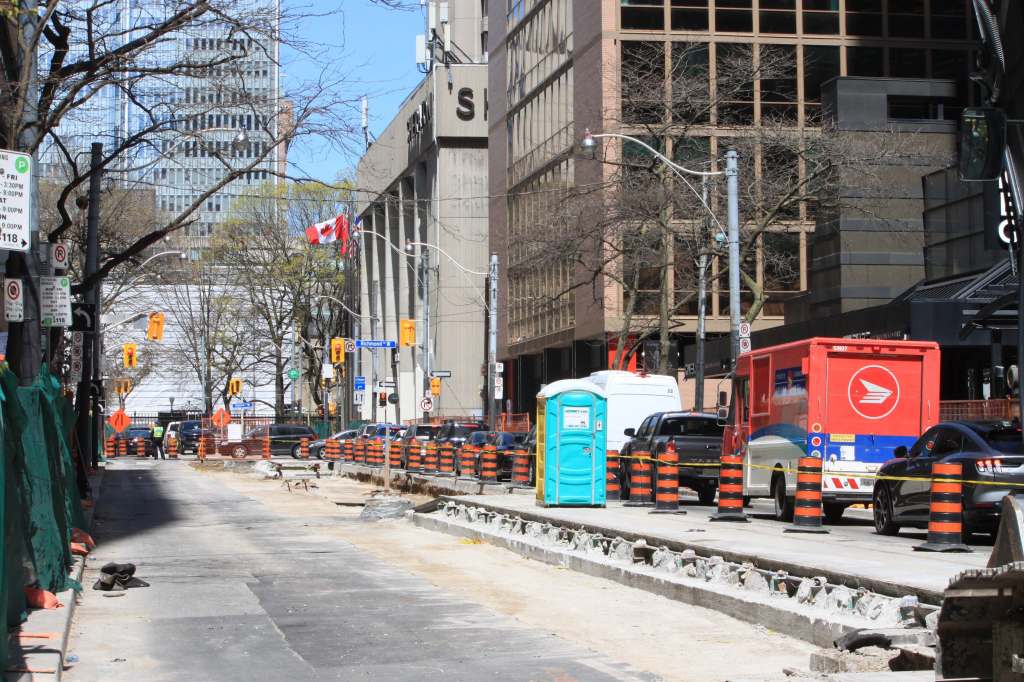
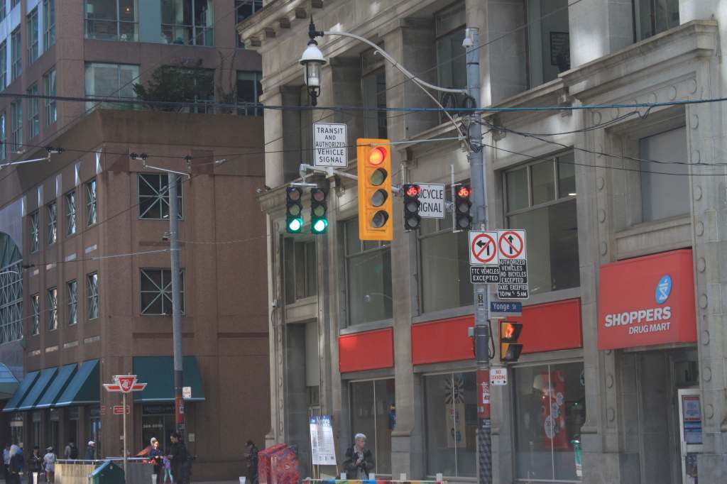
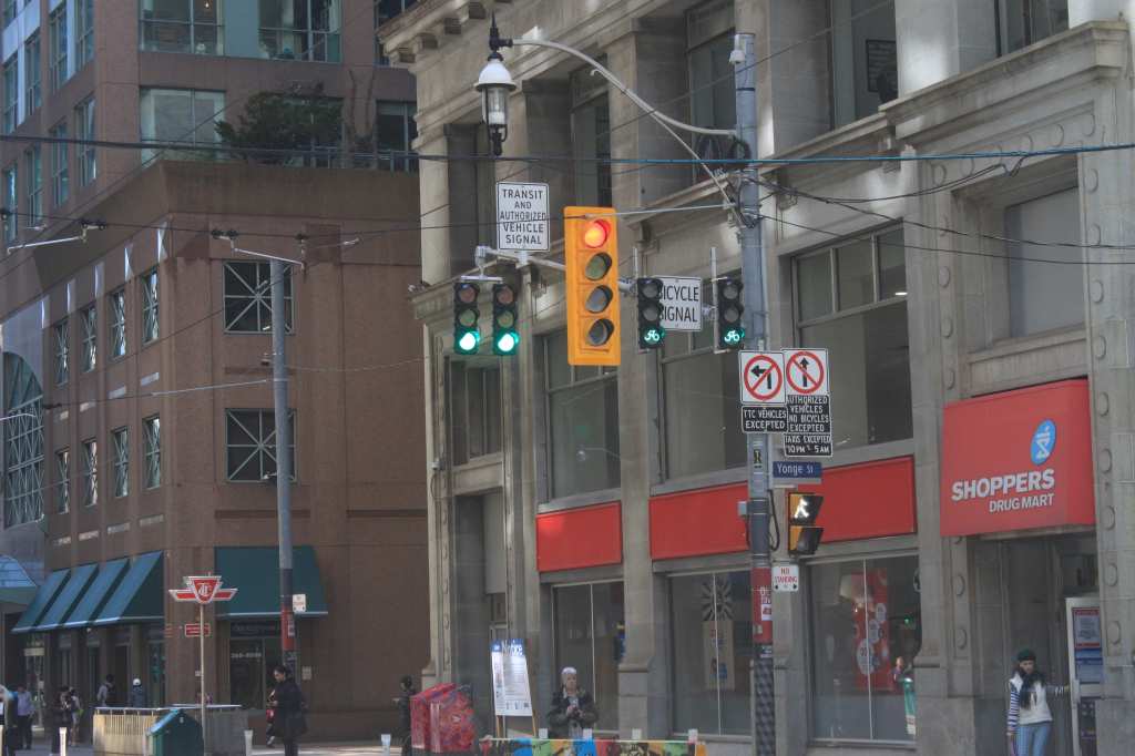
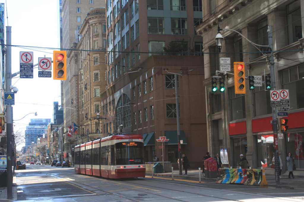
Recently, new traffic signals have been installed at the King/Yonge and King/Church intersections where through movements by most traffic is prohibited. A constant red signal with green arrows for permitted turns is intended to make through movements a “red light running” offense, although the arrangement and signage confuse motorists. The intent is that the arrangement, together with red light traffic cameras, will deter motorists from driving straight through, although it remains to be seen how well this will work.

A complication is that “authorized vehicles” (i.e. licensed taxis) are allowed through between 10pm and 5am, but to the casual observer a car is a car is a car, especially when it is operating for a service like Uber as opposed to a branded taxi with company colours. When traffic agents are present to manage the intersections, motorists go where they are told, but at other times the signals are often ignored. Driving through a full red signal is not a behaviour that should be encouraged, especially out of frustration.
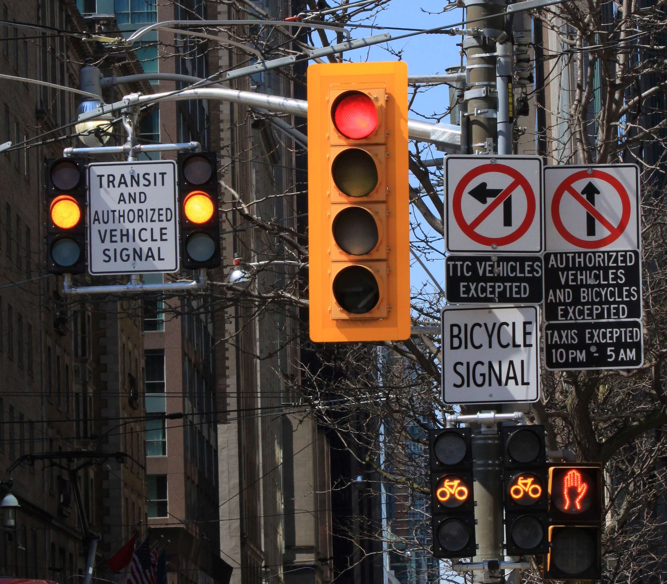
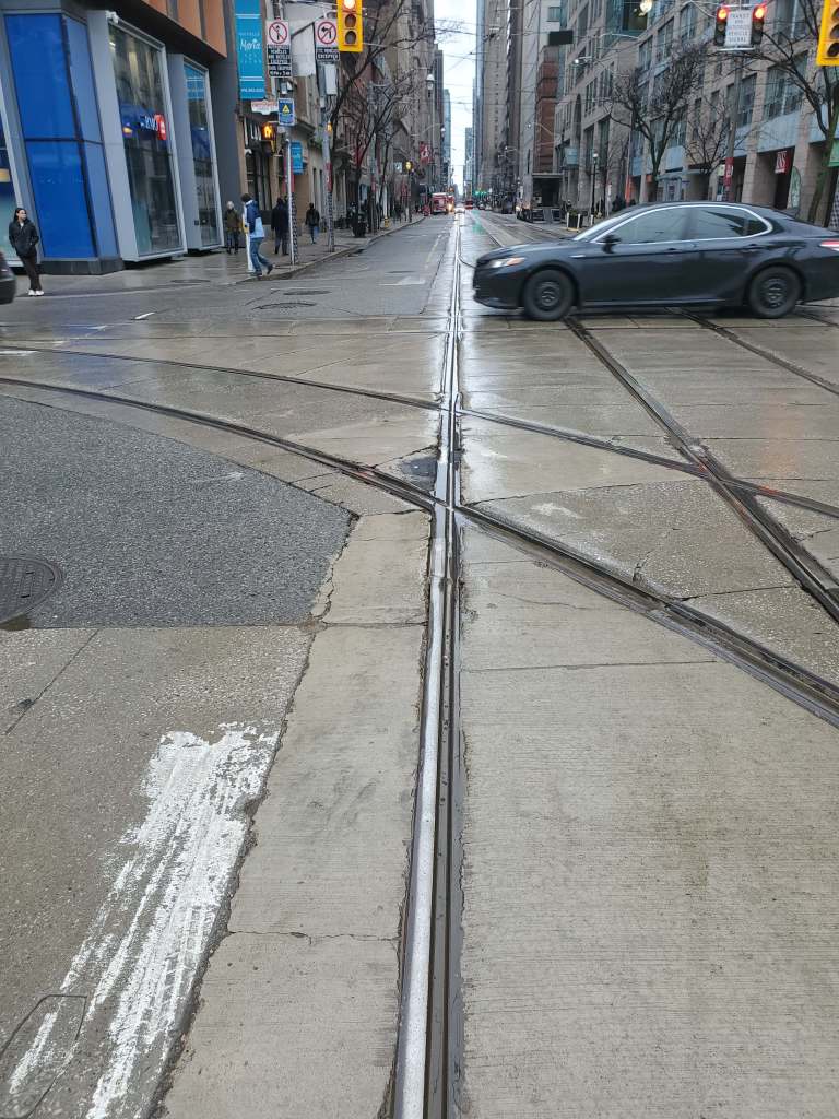
Facing west at King and Church, northwest corner

Travel times across the priority corridor dropped substantially after traffic agents prevented motorists from blocking intersections, and a further improvement is expected when work is complete on parallel streets related mainly to the 501 Queen diversion tracks for Ontario Line construction. Some eastbound traffic now attempting to use King will shift north to Adelaide.

The date for the 501 Queen shift to Richmond/Adelaide is not yet certain. However, track repairs are planned at King & Church in August, and it would make sense to have an alternate streetcar route across the core available by then. Whether it will be is quite another matter.

The effectiveness of these improvements is being monitored and, if successful, Transportation Services is proposing to implement similar changes at other locations along the King Street corridor. It is anticipated that these measures, if successful, may also mitigate the need for Traffic Agents at two or more locations.

Update Report at p. 4

In the short term, there is a budgetary issue because Toronto Police are providing direction and enforcement at some locations. This provides an incentive for technological solutions.

The City intends to purse automated enforcement, but current legislation only allows this for red light running, but not for entering and blocking an intersection because there is no space clear on the far side. “Blocking the box” cannot currently be charged against a vehicle owner, only against a driver. This must change to match red light enforcement where the owner is charged regardless of who is actually driving.

Also under consideration (and subject to the same legislative requirements) are offenses such as blocking bicycle and reserved transit lanes. (Note that there are no reserved transit lanes on King.)

What is painfully clear since the priority corridor was installed is that motorists will do whatever they damn well like unless there is enforcement. Toronto’s laissez-faire attitude undermines whatever bylaws Council might enact.

Since their installation, the curb lane pedestrian areas at stops have deteriorated. After a mid-2023 inspection, 180 missing or badly damaged yellow tactile mats and five bollards were replaced. Other needed work includes basic street cleaning, graffiti removal on barriers, pothole repair and repainting of pavement markings. These are to be addressed in 2024. Another annoyance not mentioned in the report is the relocation of stops without concurrent shifts in transit shelters and benches. The gradual decline of the pedestrian facilities on King tells its own story about the City’s real priorities.

A trial raised platform for passengers was installed at Peter Street and at Portland Street in 2019, although the latter was removed for adjacent construction activity. That platform will be “redeployed” elsewhere. Of the 20 stops along the corridor, some can accommodate platforms without any utility conflicts. Five-to-seven will be installed in fall 2024 (locations not yet named). The remaining stops require co-ordination with utilities for the effect of a platform on their access with the intent of installing these in 2025.

Some mid-block curb extensions for public realm improvements will be designed in 2024 and built in 2025. However, major work to reconfigure King Street is not planned until after 2030, presumably when the Ontario Line is open (or at least substantially complete) and its construction disruptions end. In the meantime, improvements will be made where possible in co-ordination with other construction in the area.

The bylaw governing the corridor will be amended to include the Billy Bishop Airport Shuttle as a service that is permitted to use King Street as a transit vehicle.

Continue reading →
East End Streetcar Diversions April 19-29, 2024

Once again, streetcar service in the east end will be disrupted for construction diversions, although this will not be as long lasting as projects in recent years.

Updated April 27, 2024: The diversion for work at the Don Bridge on Queen Street finished early and all streetcar routes returned to their normal routes today.

505 Dundas Late Night Diversion

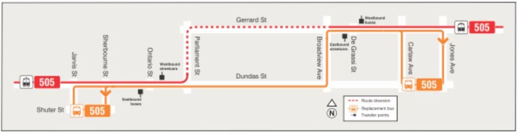
On Friday, April 19 and Saturday, April 21, service after 11pm on 505 Dundas cars will divert both ways via the Carlton route (College, Carlton, Parliament, Gerrard) between Bay and Broadview. Replacement bus service will cover the missed portion of the streetcar route. This work is for track drain repairs at Mutual Street.

501/503/504/508/301/304 Don Bridge Diversion

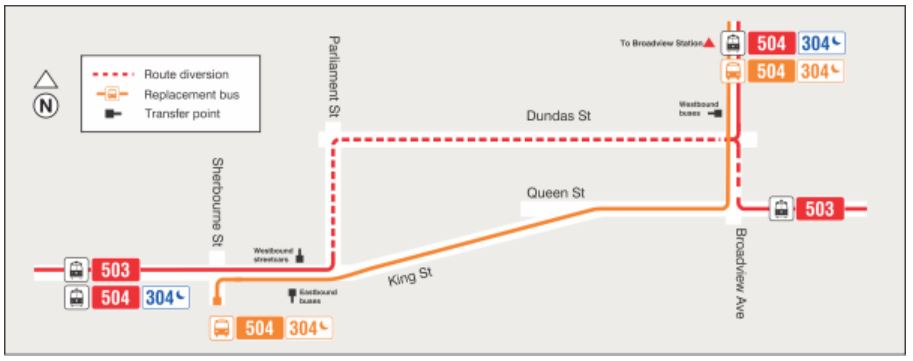
From Monday, April 22 at 4am to Monday, April 29 at 4am, all streetcar service will divert via Dundas between Broadview and Parliament to bypass expansion joint replacement on the Queen Street bridge at the Don River. The work finished early and normal routings across the bridge were restored on April 27.

Shuttle bus service will operate on Queen between Carlaw and Sherbourne, and on the King route between Broadview Station and Sherbourne.

As of 7am on April 20, the TTC has posted a Service Change notice for King Street services (503, 504 and 304), but has not yet posted one for 501/301 Queen or 508 Lake Shore although these are also affected. The 501B bus service between Broadview and Bathurst should continue on its normal route. There is also an item on their News page describing this change.

Although not shown on this map, the diversion should not affect the 504A Distillery service.

Expansion joint replacement on this bridge occurs from time to time as this is a high traffic area, and the bridge can be damaged if the joint is in poor condition from vibration of passing streetcars.

King West Construction Update

The City of Toronto has announced that the planned replacement of track at the intersection of King & Dufferin Streets will not occur in 2024 due to “supply chain issues”. Instead this work will be included in the 2025 construction schedule which already included reconstruction of King from Dufferin to Close.

The intersection replacement was originally planned for June-July with full closure of both streets. That will not happen and routes will stay on their current diversions pending reopening of King Street east of Dufferin. That was planned for year-end, but has now been moved forward to November 2024.

The project website contains current details of plans.

King, Adelaide & York Update: April 2024

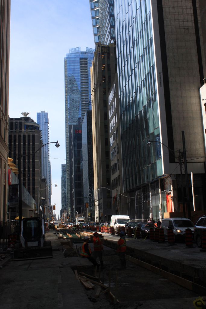
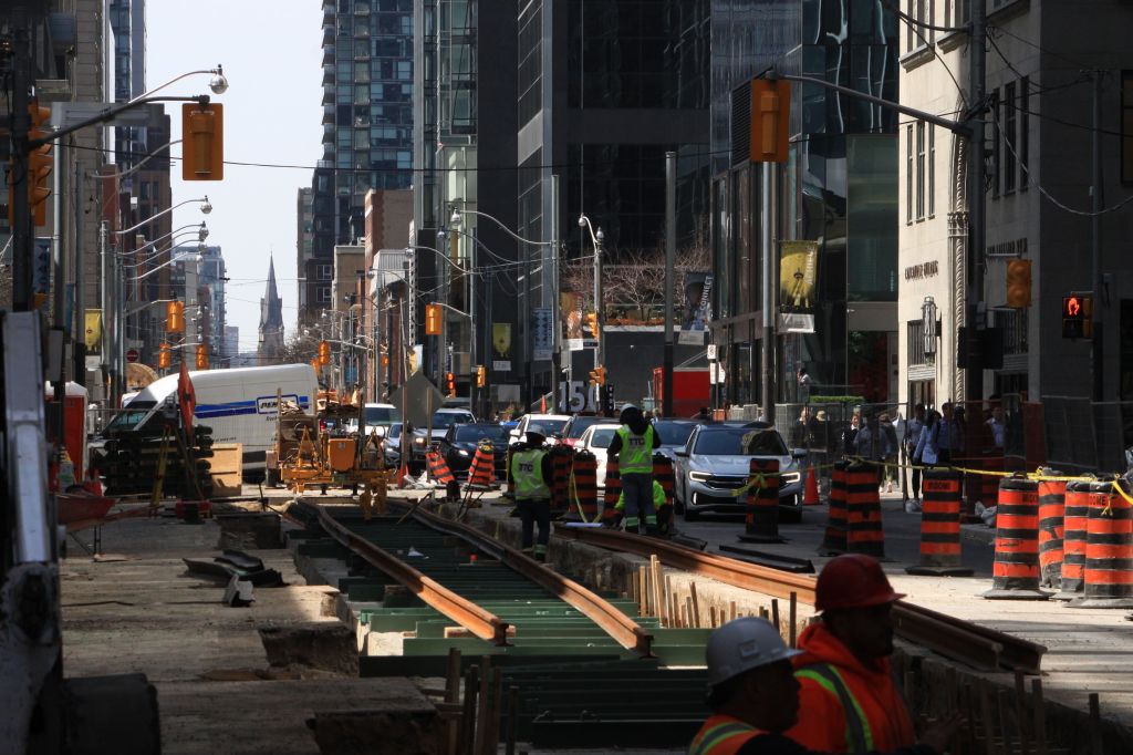
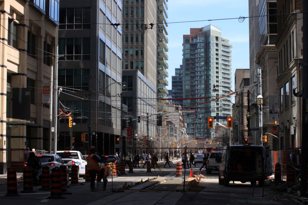
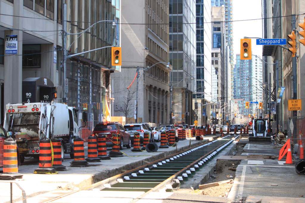
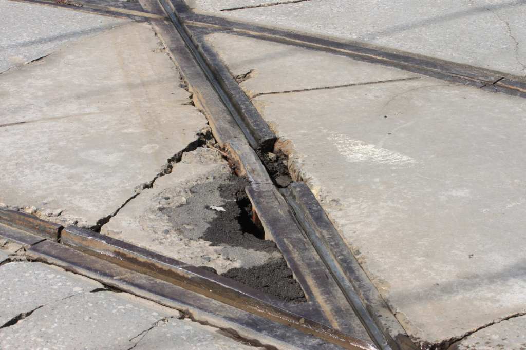
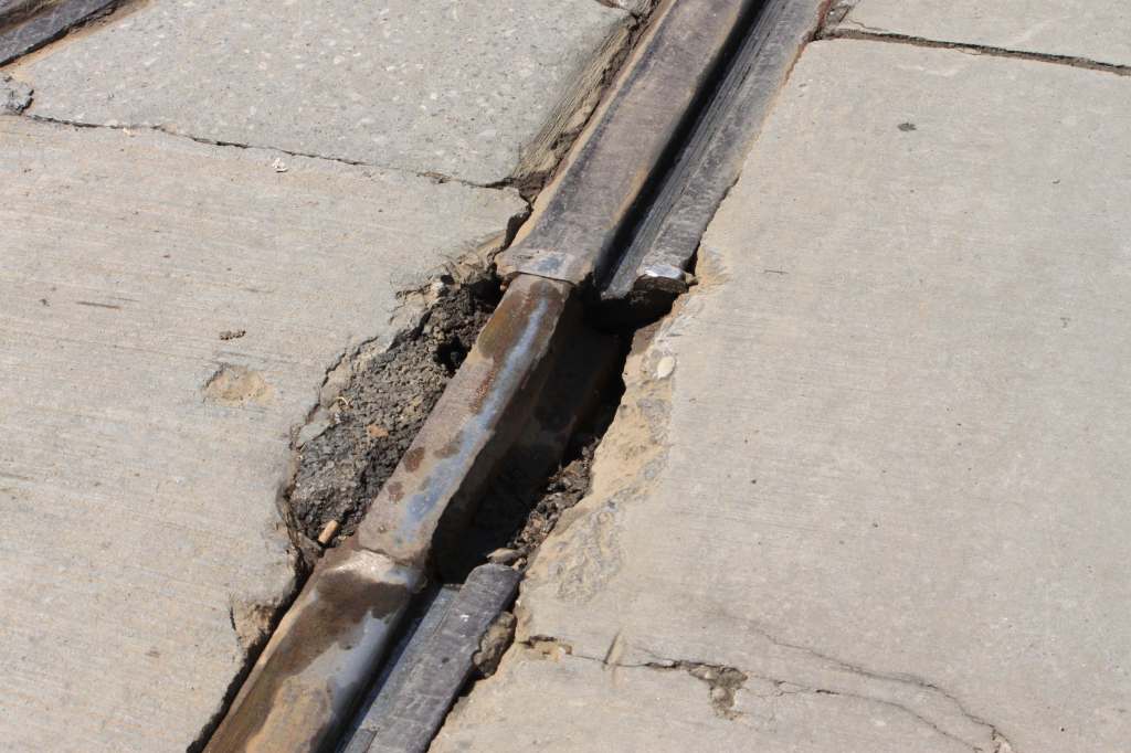
Adelaide Street track almost finished! New traffic signals on King! Almost no work on York Street. And some really appalling track.

All photos in this article were taken by me on April 10 and 14, 2024.

Updated April 17, 2024: Photos showing pavement patching at King & Church added.

Updated April 21, 2024: Photo showing rail gap and pavement patch on westbound rail, west side of the intersection added.

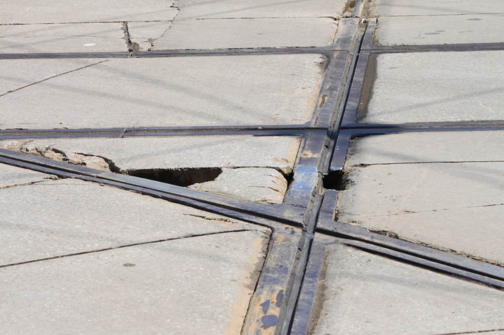
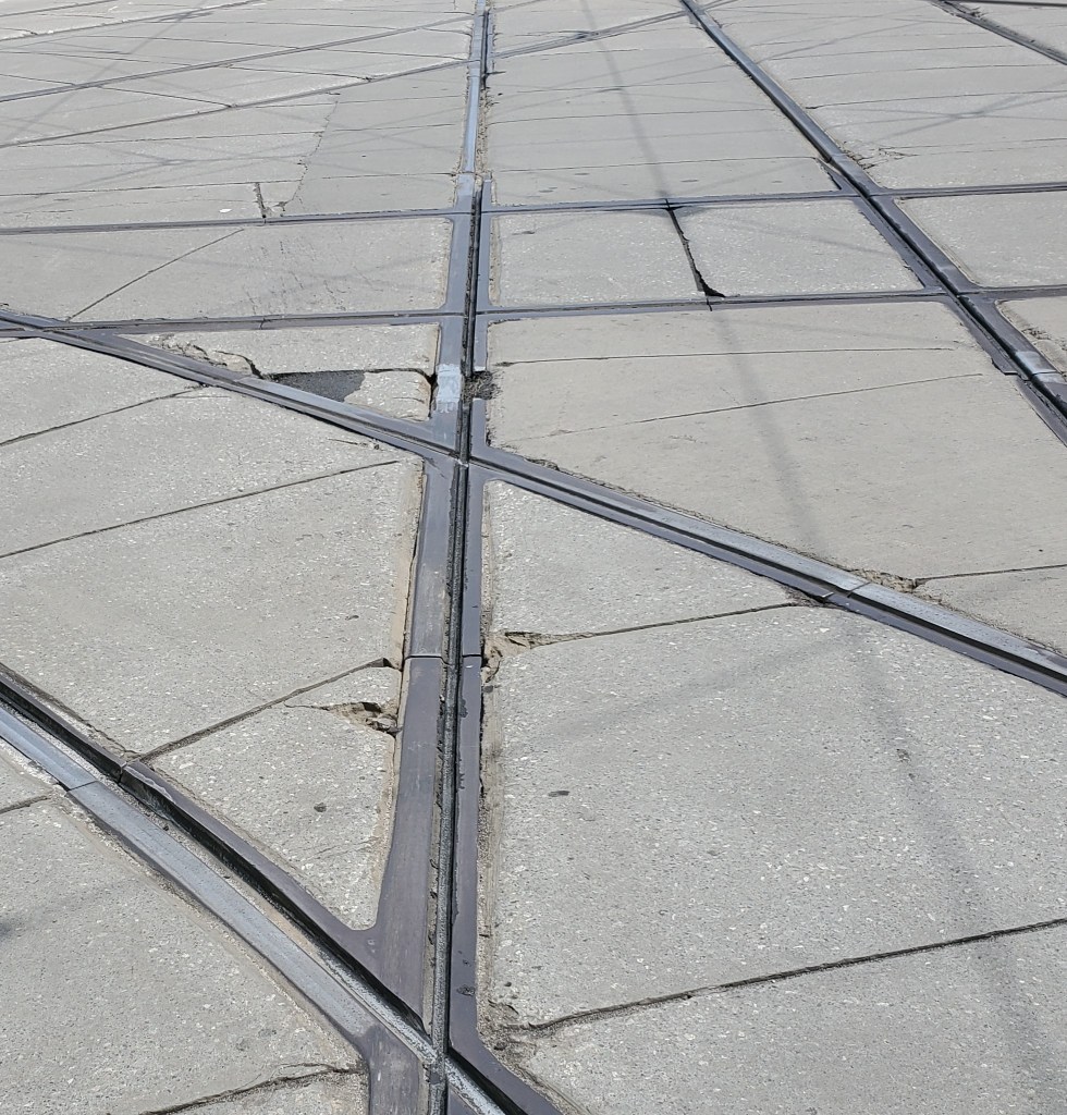
The basic problem with some of the repairs is that they do not necessarily provide a continuous surface for streetcars. The reason for this is that the diamonds are designed to carry cars on their flanges so that the main part of the wheel does not produce the familiar “thunk” where at the crossing of two tracks. Some of the breaks shown here are within the diamond, and the flange way has completely broken off. As streetcars pass, their wheels fall off of the adjacent intact flange way into the gap even though the main rail head is continuous. This is particularly evident on the northerly westbound rail (see photos at the end of the article).

Updated April 26, 2024: Photo of work in progress on York Street south of Richmond added.

Adelaide Street

The two remaining chunks of new/replacement track are finally being installed on Adelaide Street, and some work is underway for new overhead. This will be the eastbound 501 Queen diversion for the Ontario Line construction.

York Street

Almost nothing has happened with the new track to be installed on York south from Queen. There is a pile of rail on Queen west of York, and some pavement cuts prior to excavation, but that’s all. Metrolinx is not exactly rushing with their part of the project.

Updated April 26, 2024

Excavation for a new trackbed appears to be complete between Richmond and Adelaide Streets.

Looking north from Adelaide toward Richmond on York. Apr. 26/24

King Street Signals

New signals intended to deter straight through auto movements have been activated on King at Church and at Yonge. The intent is to make a straight through movement one that must drive against a solid red signal. If the City ever installs red light cameras, there will be a bonanza in tickets.

The design provides separate signals for pedestrians, cyclists and authorized vehicles (mostly transit, but also taxis from 10pm to 5am). The signage, already complicated, is now more extensive and guaranteed to confuse any motorist. Indeed, during my visit, a 501 Queen bus created a traffic jam waiting for a conventional green signal while ignoring the transit signal.

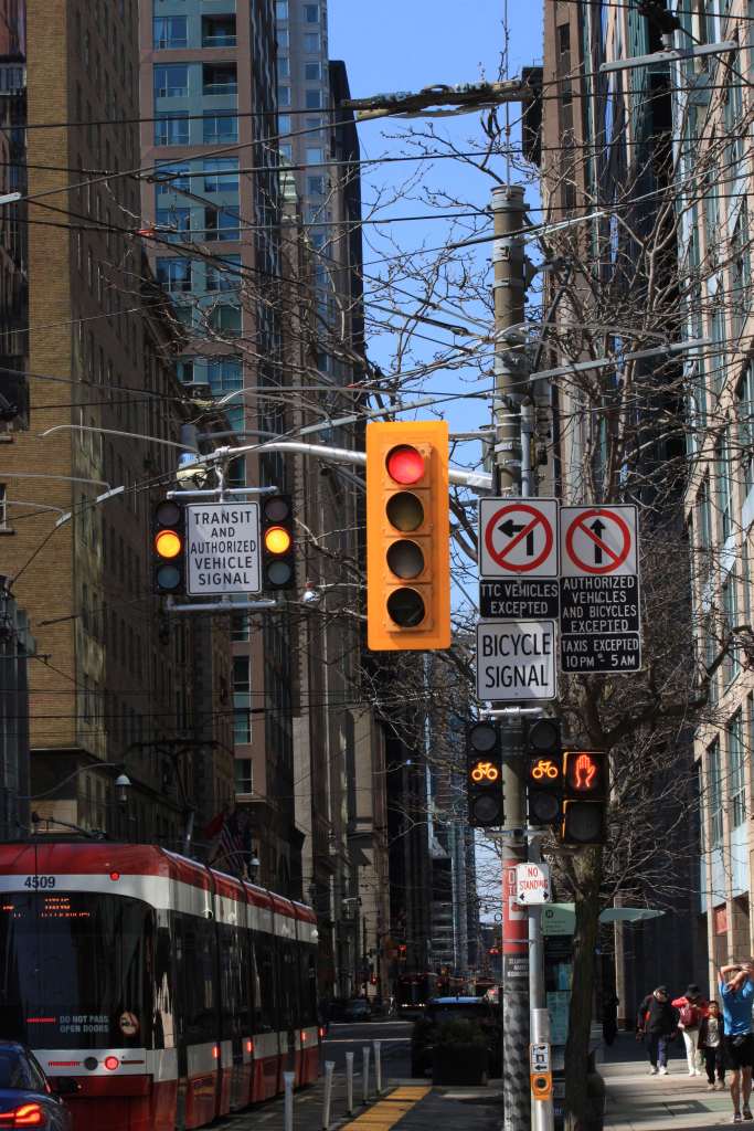
Here is the collection of signs westbound at King and Church Streets. The signals are in the process of turning red for King, and they show an amber aspect for transit and cyclists.

An important point about signals is that they do not only tell people what they can do (for example, the red hand tells pedestrians not to walk, a green bicycle tells cyclists they can proceed). This gives some hint to everyone of how all traffic is expected to behave.

Nobody knows what an “authorized vehicle” is, and this is especially tricky for unmarked “cabs” like Ubers. If a car drives through a full red signal, is it allowed or not?

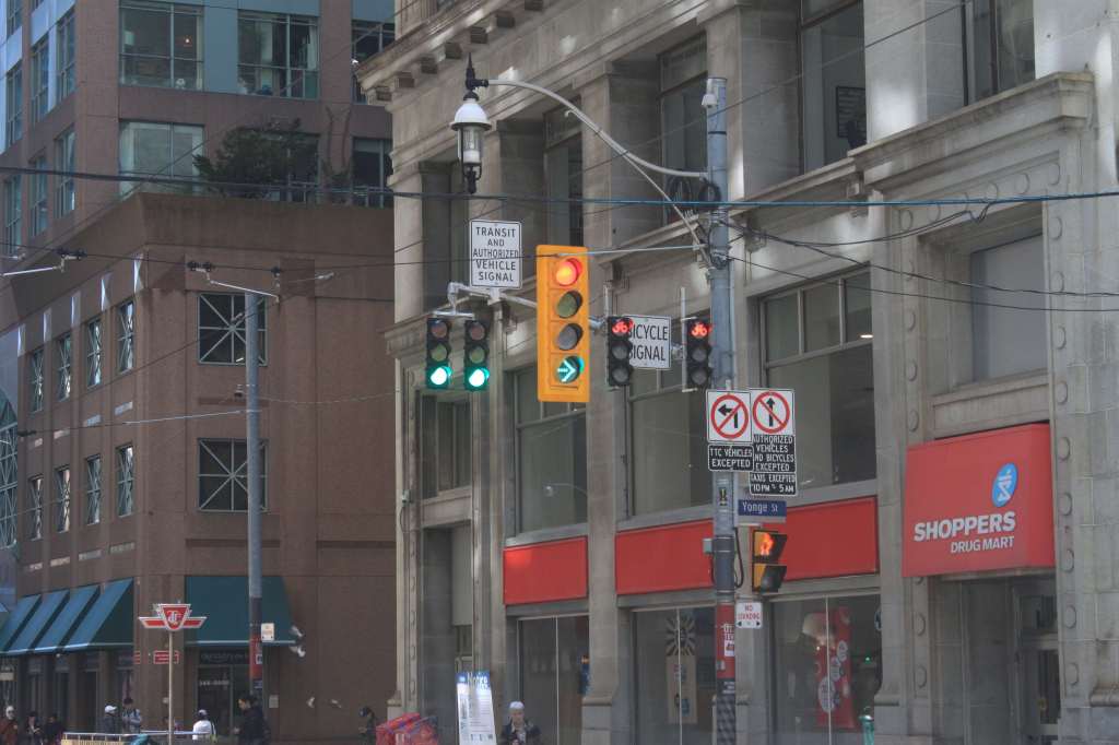
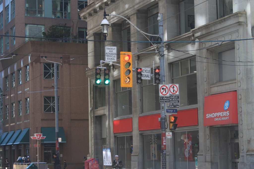
The large red aspect on the main signal (with the yellow backboard) never changes, but it will on occasion be joined by a green arrow in the bottom aspect.

Here is the cycle of displays eastbound at King and Yonge as east-west travel gradually opens up.

This confusion shows how important the establishment of simple, clear barriers like a few short transit malls with planters and other physical limitations. Send motorists a clear message: “Don’t even think about driving here.”

All photos taken on April 14, 2024.

King & Church Track

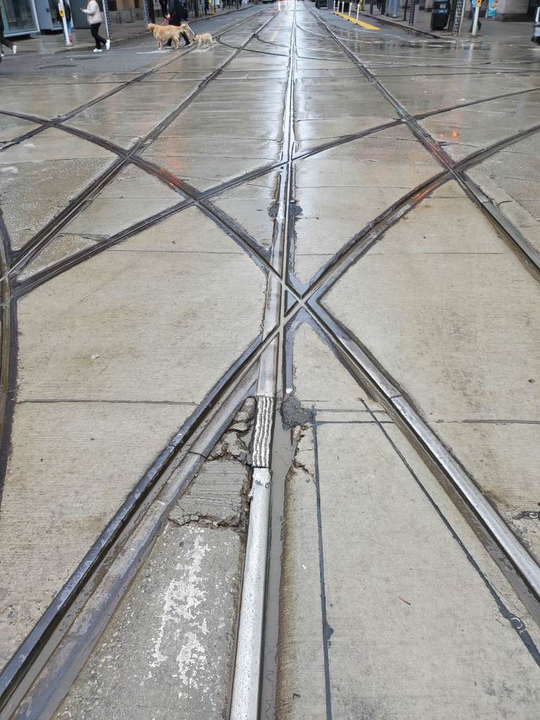
Although the TTC told a good story recently on their subway track maintenance, the situation on the streetcar network is not quiet so rosy. A low point is at the intersection of Church & King, long overdue for complete reconstruction, where there are three separate pavement gaps and ad hoc rail repairs.

It is hard to take TTC claims that they value safety highly and repair faults promptly with conditions like this.

Updated April 17 & 21, 2024: The photos below show recently applied pavement patching.

King & Queen West Service Changes February 18, 2024

For those who have been wondering where my usual wrap-up of coming service changes is, it seems to be stuck in the managerial bowels of the TTC. A few weeks ago I was led to believe that its release was imminent, but as of the evening of February 11, crickets.

See also:

There is an online public event on the evening of Thursday, February 15 for which you can register via the City’s site. You can also subscribe to updates on the City’s page (the link is at the bottom).

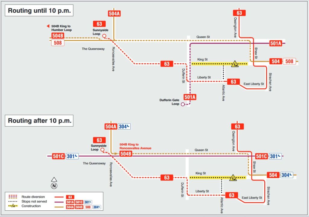
Major changes to routes in the Parkdale and Liberty Village area are coming on February 18, and the details have been posted for a while elsewhere. Time for me to catch up. When the service memo comes out, I will flesh this out with service frequency details. Here is a map showing the wandering routes in the west end.

King Street will be closed between Shaw and Dufferin for water main and track work. This is a multi-stage project, although from a transit point of view it will have two configurations.

Effective February 18, 2024:

King Street will close between Shaw and Dufferin. Various routes will change to provide service, such as they can.

63 Ossington will no longer loop northbound via Atlantic and King to Shaw, but will be extended west via Liberty, Dufferin and King to Sunnyside Loop west of Roncesvalles.

29/929 Dufferin routes are not affected at this stage of the project.

501 Queen will vary by time of day. The eastern terminus remains at McCaul Loop, but the western terminus will change.

  • Until 10pm, all 501 Queen cars will run only as far west as Dufferin Street, and they will turn south to Dufferin Loop (CNE Western Gate).
  • After 10pm, all 501 Queen cars will run through to Long Branch as they do now replacing the 507 Long Branch car.

301 Queen night car bus service will continue to operate between Neville and Long Branch.

504 King cars will also vary by time of day:

  • Cars on both the 504A and 504B branches will divert via Shaw and Queen to Roncesvalles.
  • 504A Dundas West cars will run north to Dundas West Station at all times.
  • 504B cars that would normally run to Dufferin Loop will run west on Queen.
    • Before 10pm, 504B cars will run through to Humber Loop replacing the 501 Queen service which will divert to Dufferin Loop.
    • After 10pm, 504B cars will terminate at Roncesvalles.
  • Note that streetcar service to Broadview Station will be restored and so the 504B cars will no longer end at Distillery Loop, but will run to their normal east end destination.

304 King night service will operate between Broadview and Dundas West Stations diverting via Shaw and Queen. [Updated Feb. 12 at 11:40am] The TTC media release confirms that the night service will operate with streetcars.

507 Long Branch service is not affected.

508 Lake Shore cars will divert via Shaw and Queen, but will otherwise operate on their normal route.

Effective Late June 2024

Note: The work at King & Dufferin has been postponed to 2025.

The intersection of King & Dufferin will close for complete reconstruction of the track. This will require changes in the 501 Queen and 63 Ossington diversions, as well as a revised south end for the 29/929 Dufferin services, but details have not yet been announced.

Effective August 2024

With the completion of work at King & Dufferin, routes should revert to the February configuration, but nothing is definite about TTC plans as riders know well. Stay tuned.

The work is supposed to continue until “early December” according to the TTC site, but until “November” according to the City site. Normally, the schedule change would occur in late November, and so it is not clear just what date they are aiming at. The usual December change is for the two-week holiday schedules just before Christmas.

King Street Update — January 2024

Updated February 11, 2023 at 1:45 pm: In response to a reader comment, I have added illustrations from the City’s presentation deck showing the technologies used for traffic monitoring and analysis at the end of this article.

This article continues a series of reviews of operations on the King Street Transit Priority Lane of which the most recent is King Street Travel Times: May-December 2023.

On February 9, 2024, Mayor Chow held a press conference to announce various changes coming to King Street and the success of the Traffic Agent program in taming congestion downtown, particularly on King.

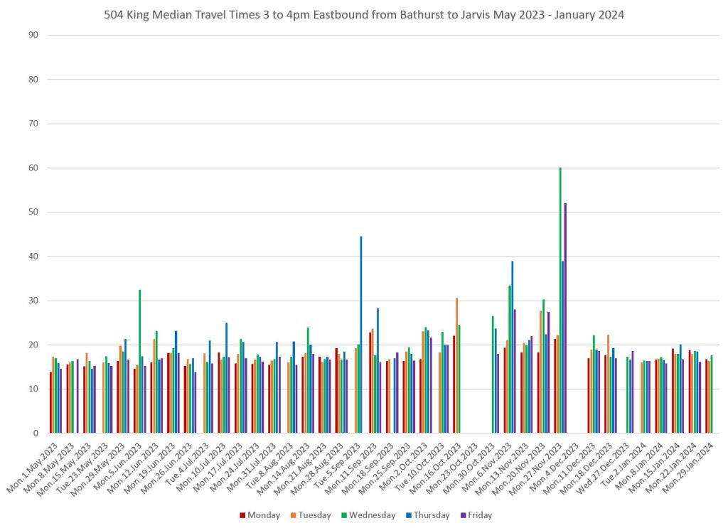
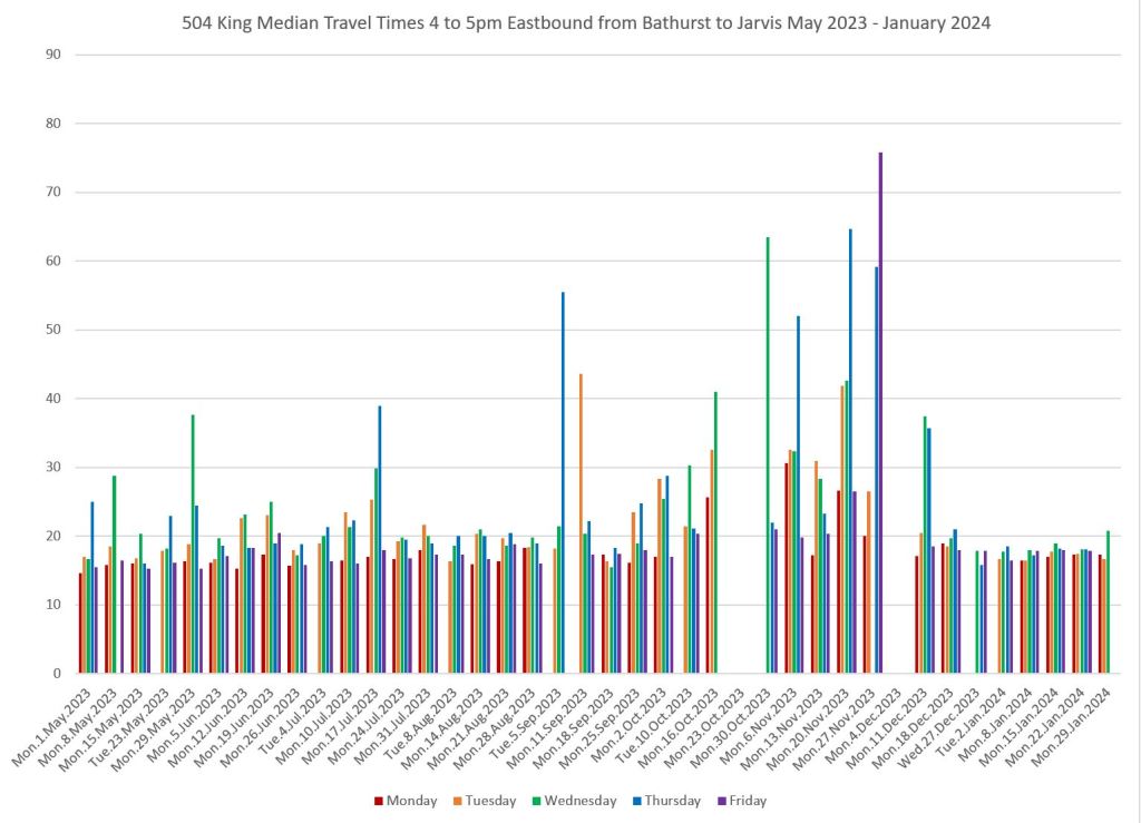
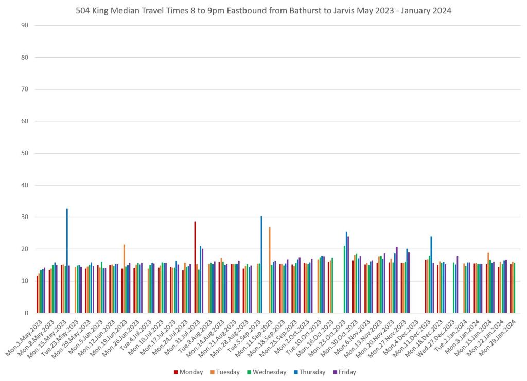
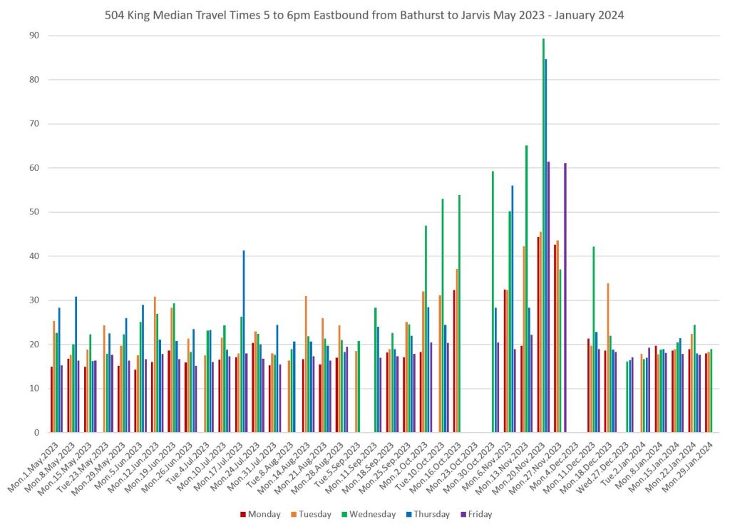
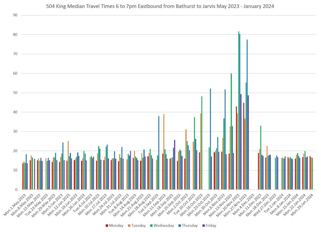
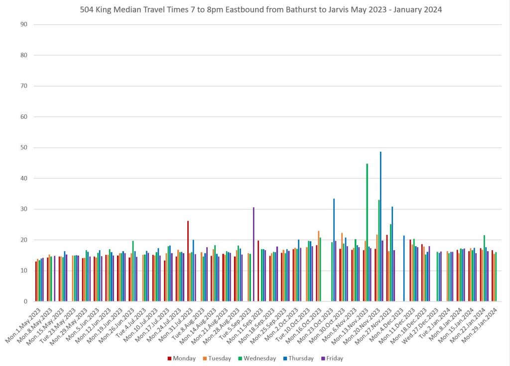
Regular readers will know the graphs below showing day by day travel times eastbound from Bathurst to Jarvis by hour from 3pm to 9pm. These charts have been updated with January 2024 data. (Note: Gaps in the charts in mid October and early December correspond to diversions via Church and Queen for water main repairs east of Jarvis. No streetcars covered the full Bathurst-Jarvis segment during these periods.)

The graphs illustrate the change in congestion levels peaking in the 5-6pm hour, but still quite evident in 6-7pm and to a small extent in 7-8pm. The build-up through the fall was caused by construction on Adelaide coupled with a complete lack of enforcement of the transit corridor and of “box blocking” at major intersections where cars enter but cannot cross in the allotted green time. With the introduction of Traffic Agents to enforce the rules on November 27, 2023, the street ran much more smoothly and the peak in congestion vanished.

Continue reading →
How Slow Is My Streetcar: Part I

At its November 2023 meeting, Council passed a motion proposed by Councillor Chris Moise whose ward covers the east side of downtown, and who also sits on the TTC Board:

1. City Council direct the General Manager, Transportation Services, in consultation with the Toronto Transit Commission, the Toronto Police Service, and the City Solicitor to review and report back to the Executive Committee in the second quarter of 2024, including:
a. an update on streetcar performance over the last five years;
b. suggested improvements to the public realm along King Street until the permanent capital project can be delivered; and
c. the feasibility of implementing automated traffic enforcement on the King Street Transit Priority Corridor, including details on what legislative amendments would be required to provincial legislation including, but not limited to, the Ontario Highway Traffic Act.

This article addresses point “a” with a review of streetcar lines over the past five years. It is important to go back to 2019 before the pandemic fundamentally shifted traffic and transit patterns downtown as a point of reference.

From time to time, there are calls to expand a “King Street” redesign to other parts of the network, but there are two “cart before the horse” issues to address first:

  • Figure out how to make King Street operate as it was intended and return at least to its pre-pandemic behaviour, if not better, as a model.
  • Understand how other streets operate including where and when problems for transit performance exist.

An update on transit priority will come to Council in February 2024, although this will look more widely at the city, not just downtown. In previous articles I have reviewed the growing problem of transit travel times as traffic builds on the proposed RapidTO corridors, some of which exceeded pre-pandemic levels some time ago. In future articles I will refresh these analyses with data through to the end of 2023.

An important distinction between most RapidTO bus corridors and the downtown streetcar system is the design of suburban vs downtown streets. In the suburbs, the streets are mostly wide, have relatively few points of access (e.g. driveways) or pedestrian oriented uses (e.g. shops), and travel distances tend to be longer. In the core, streets are narrow, mostly four lanes with no possibility of widening, access points are more frequent, there is a strong pedestrian orientation, and trips tend to be short. Even if buses were running, express operations would be almost impossible and would save very little time on the downtown routes.

There are exceptions such as some older parts of the inner suburbs that bring physical challenges for transit priority, but also the political challenge that the transit share of road use is lower as one moves outward from the core. King Street is a very different place from Steeles, and Dufferin is somewhere in between depending on which section one considers.

An important message in all of this is that “congestion” (put in quotes because it is so often cited as a get-out-of-jail-free excuse for all transit woes) varies from place to place and time to time. Simply putting transit priority everywhere will not solve all problems and could even be overkill (even assuming that it is true “priority” and not a sham to keep transit vehicles out of motorists’ way). It is simple to colour a bunch of key routes end-to-end on a map, but much harder to identify changes that will actually make a difference. Meanwhile, a focus on “priority” could divert attention from badly-needed improvements in headway reliability and more reliable wait times.

This article begins with a comparison of scheduled travel speed on each route, and then turns to actual travel speeds by route segment. In the interest of length, I will leave a discussion of headway reliability to future articles. This is an important component of total travel time, especially for short trips or trip segments.

I have also included tables showing the constant change in route configurations on the four major east-west corridors thanks to a never-ending procession of track and water main work, rapid transit construction, and overhead changes for pantograph operation. Some of this work was accelerated to take advantage of lighter traffic conditions during the pandemic, and some to bring forward work to keep staff employed.

However, the rate of route changes persisted well beyond the heart of the pandemic and threatens the credibility of transit service on major corridors leaving riders constantly wondering where their streetcar or replacement bus might be. Some changes occurred without the planned work actually taking place, or work started and ended later than announced (sometimes much later as in the never-ending KQQR project).

An important change over recent years, separate from the pandemic, has been the move to larger streetcars on wider headways. What might have been a tolerable unevenness in service when streetcars arrived every 4 or 5 minutes simply does not work for scheduled headways of 10 minutes with much wider swings. Bunching when it occurs leaves much bigger gaps between vehicles. A laissez faire attitude to route management, and especially the assumption that routes under construction cannot be managed, has led both to unreliable service and basic questions of how or if the TTC can recover the quality riders expect.

For all the talk of project co-ordination, the last people who seem to count are the riders. Simply studying raw travel times be they scheduled or actual does not capture the frustration, delay and despair from the ever-changing and unreliable services, be they by streetcar or bus.

Continue reading →
King Street Travel Times: May-December 2023

This article is an update to King Street Travel Times: May-November 2023 incorporating data for December 2023. The charts here show the variation on a day-to-day basis for selected hours of service including the morning peak 8-9am, midday 1-2pm, and hourly from 3pm to 11pm.

Items of note:

  • The problems in late 2023 were predominantly eastbound caused by a combination of auto traffic entering the King Street corridor and filling all available capacity, and by delays eastbound at Church for TTC vehicles making left turns on diversion routes.
  • There are early signs of this problem in the hour from 1 to 2pm, but it worsens dramatically from 3pm onward and travel times do not settle down to normal values until after 7pm.
    • This shows the need for traffic management over an extended period, not just for a short “peak within the peak” interval.
    • The problem receded somewhat in December with the implementation of traffic wardens, but various construction projects, some unplanned, also affected the street.
  • The day-to-day variation in travel times, and by extension in the amount of competing traffic, generally peaks on Wednesday.
    • This was already evident in Spring and Summer data indicating a problem brewing for later in the year as construction affected parallel roads.
    • The peaking within the week, and the different behaviour by time-of-day and direction show the folly of citing “average” values. By extension, the quality of service varied substantially depending on the level of congestion, and this affected entire routes, not just the downtown portion.
  • There is a regular increase in travel times in the evening, notably on Fridays, corresponding to the busy day in the Entertainment District. This is not as severe as the peak period delay eastbound, but it is a quite regular occurrence.

When the January data are available, I will update these charts to show how consistently the December improvements have survived past the holidays and without major construction works on Adelaide Street.

Continue reading →
Downtown Route Changes Effective December 11, 2023 (Updated)

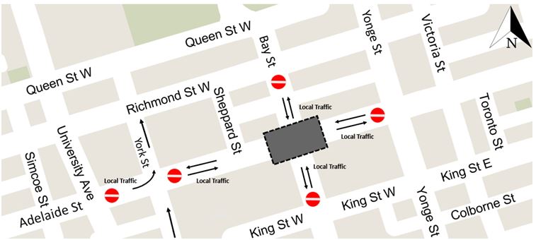
The City of Toronto will completely close the intersection of Bay & Adelaide from 7am Monday, December 11 to 7am on Saturday December 16 to all vehicles. Bay and Adelaide Streets will be open only for local traffic in the immediate area of the closure. This continues the work of (re-)installing streetcar track on Adelaide for the eastbound 501 Queen streetcar diversion around Ontario Line contruction.

Updated: Work at Bay and Adelaide actually completed on the afternoon of Friday, December 15 and the intersection reopened earlier than planned.

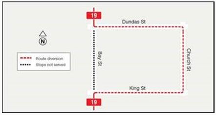
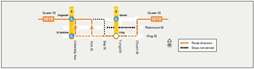
This will require diversion of the 19 Bay and 501B Queen bus routes.

The 19 Bay bus will divert via Dundas, Church and King both ways.

The 501B Queen bus which normally operates on Bay from King to Queen will use York Street for north/westbound trips and University Avenue for south/eastbound trips. Buses will operate both ways via King Street, and there will be no westbound service on Richmond Street

[Apologies for the soft images. They are from a City construction notice, and I used what is available.]

End of the King East Diversions

As the map for 501B Queen above shows, service is supposed to resume the normal routes east of Church with the completion of water main and Hydro work on the coming weekend which has a December 10 end date. This means that:

  • 501B Queen buses return to Queen Street east of Church
  • 503 Kingston Road streetcars return to King Street between the Don River and Church
  • 504 King streetcar service to Distillery Loop resumes

Updated December 11, 2023 at 4:15 pm

Another diversion has been added to the list. The 505 Dundas cars will divert both ways via Parliament and Gerrard. A 505 shuttle bus will run from Jarvis to Jones.

This diversion is required for track repairs, and will last until Thursday, December 21, 2023.

Updated: This diversion ended on Tuesday, December 19.

East End Route Diversion Update

This post consolidates information about the diversions affecting east end bus and streetcar services as a convenience for readers.

Construction projects affecting these routes include:

  • Water main repairs on King between George and Sherbourne. This is a permanent repair for the problem that diverted all service in late October due to a sinkhole.
  • Reconstruction of Broadview Station Loop.
  • Adelaide Street reconstruction for the Ontario Line streetcar diversion.
  • Ontario Line construction at Queen and Yonge.

Routes as of Tuesday, December 5

501D Queen East streetcars run between Neville Loop and Distillery Loop via King west of the Don River. The easiest way to connect with these cars is to take any route headed east out of downtown that goes far enough to make a transfer connection with the 501D. Note that this is tricky at King and Sumach because stops are not well-located for a transfer connection eastbound there.

503 Kingston Road streetcars run between Bingham Loop and (officially) King and Spadina diverting via Queen between the Don River and Church Street. In practice, much of this service turns back via the traditional 503 downtown loop via Church, Wellington and York to King. If you want a 503 eastbound from anywhere west of York, it is best to get on any eastbound service and transfer to the 503 at Bay or Yonge. If you transfer at York, the 503 stops on the SE corner. Note that at Church and King Streets, eastbound 503 streetcars stop on Church just north of King. [Corrected 6:05 pm, Dec 5]

501B Queen buses that run between Bathurst (Wolseley Loop) and Broadview and Gerrard have swapped their route east of Church with the 503 cars. The 501Bs run on King Street, and the 503s run on Queen.

504 King streetcars are all turning back at Church Street looping via Church, Richmond, Victoria and Adelaide because they cannot run east on King.

504/505 King/Dundas shuttles operate from King and Parliament to Broadview and Danforth making on street stops on the NW and SW corners of that intersection. Subway connections are via a walking transfer. These buses continue west across the Viaduct to Castle Frank Station.

Both the 501B and 504/505 buses do not stop eastbound on Queen at Broadview, but instead stop northbound on Broadview beside the parking lot. Westbound buses stop at the usual southbound stop on Broadview at Queen.

504 King shuttles to the Distillery run from a downtown loop of Church, Wellington and York Streets, and they serve the eastbound stops on King at Bay and Yonge Streets, among others. At the Distillery, they are supposed to loop west from Cherry via Mill, Parliament and Front to Cherry. They do not serve Distillery Loop.

508 Lake Shore streetcars normally operate east on King looping via Parliament, Dundas and Broadview. They are diverting via Queen and Church. This is a peak only service.

There is no change to the 505 Dundas streetcars which continue to operate to Woodbine Loop via Gerrard and Coxwell east of Broadview.

Beware of TTC notices posted at stops as they are almost certainly out of date, incomplete or inaccurate thanks to the frequent route changes. There is a particular problem with outdated notices remaining at stops sometimes without a current replacement, or the “new” sign might be found in a different location (pole, transit shelter) than the “old” ones.

King Street water main work is supposed to be completed by the coming weekend, Sunday, December 10, and routes should go back to a somewhat less chaotic arrangement.

Effective Wednesday, December 6

Although Broadview Station Loop is still closed for construction, Broadview Avenue itself is open. Effective December 6, the 62 Mortimer and 8 Broadview bus routes will resume operation on Broadview stopping at Danforth at the NW (southbound) and SE (northbound) corners for subway connections.

These buses will continue south on Broadview to Gerrard, but will run out of service and loop via Gerrard, St. Matthews and Jack Layton Way. Riders making a transfer between these routes and the 504/505 King/Dundas shuttle should note that this does not stop at the same stops as the 8 and 62 buses. Southbound 8/62 riders would get off on the NW corner at Danforth and cross to the SW corner to catch a 504/505. Northbound 504/505 riders would get off on the NW corner (farside) at Danforth and walk back to the SE corner to catch a northbound 8 or 62 bus.

Effective Monday, December 11

For one week, the intersection of Bay and Adelaide will be completely closed to traffic. The TTC has not yet announced diversions for 19 Bay and 501B Queen (eastbound) buses.

Traffic congestion on King will no doubt be even worse during this period.