This article is based on the public presentation held on September 18, 2017 at Harbourfront Centre. A similar presentation will be held in southern Etobicoke on September 26.
The “Waterfront Transit Reset” project was launched by Council at the end of 2015 to review all of the outstanding plans for transit from the Mississauga border to Woodbine Avenue. The first phase of this review reported in July 2016, and that provided the springboard for Phase 2 which will report to Executive Committee on October 24, and thence to Council at its meeting beginning on November 7.
Given the geographic scope, the review has been broken down into segments (and a few sub-segments) to focus on problems particular to locations across the waterfront. The four main segments are:
- Southern Etobicoke
- Humber River to Strachan including Parkdale and Exhibition Place
- Strachan to Parliament including the Central Waterfront and much of East Bayfront
- Parliament to Woodbine including the Port Lands
The presentation was done west to east, and in a single go without questions. This was something of a marathon for the audience, and I am not sure this was the best approach given the complexity of issues in some areas. As someone who has followed the detail of this study since its inception and participated in consultation sessions, I am quite familiar with the issues and was just getting an update. Those who came to this fresh, as many did, had a lot to take in.
A further problem is that the presentation included no cost estimates, and limited information on issues such as construction effects and complexity that could inform a choice between alternatives. This is particularly true of the review of Union Station. There are no travel time estimates to show what time savings, if any, various options present. Such estimates must exist as they are a critical input to the demand modelling process.
For this article, I will take a different approach and deal with the simpler parts of the study first just to get them out of the way, leaving the knottiest problems to the end.
Updated September 26, 2017 at 5:30 pm:
The presentation file is now available as a PDF. The display boards can be viewed on the project website.
Projected Demand in the Waterfront
The heart of any transportation study is the demand projection for various components under review. The chart below shows the 2041 AM peak hour demands forecast by the City’s planning model.

There is a fundamental difference between the projected demands from the western part of the line and the eastern one. From the west, the demand has the conventional inbound-to-core pattern for the AM peak. At the core and to the east, the peak flow is outbound, south to Queens Quay and east to new office and school developments.
This chart is missing some vital data that would put other parts of the discussion in a better context:
- It assumes the presence of the Bremner link although this is the least likely to be built beyond an upgraded bus service.
- There is no screenline west of Bay Street to indicate the demand arriving and leaving to the west right at the portal. With 2,350 going east and 3,700 coming south, this implies a substantial outbound demand to the west. Without the 750 each way on Bremner, these numbers would be higher.
- The comment about higher demand in the east without the Relief Line does not explain whether the modelled values shown here include that line or not.
It is impossible to evaluate the demand numbers when there is no sense of staging of projects or of networks with some pieces “in” or “out” of the mix.
There is also no sense of the time frame over which the various demands will evolve, only that this is the 2041 end state. Any decision of the order of projects (and indeed their worth relative to other parts of the transit network) must be in the context of changes that are anticipated in the short, medium and long terms. This also begs the question of whether there are changes in the pipeline that will require heroic efforts in building up transit service to avoid short changing growing parts of the city (much as we already see in Liberty Village).
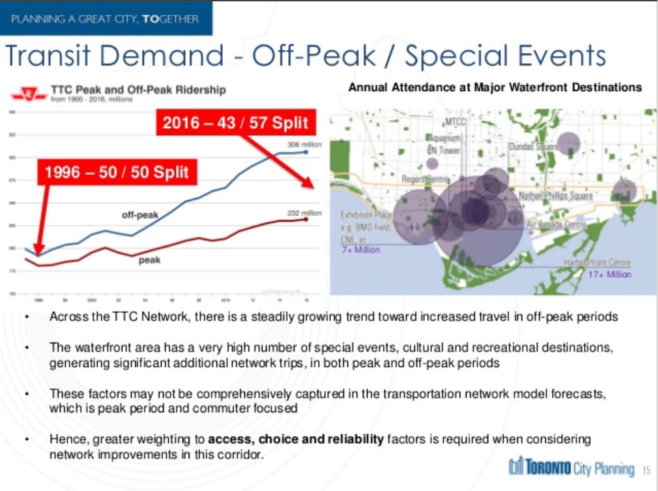
Another factor in any plans for the Waterfront network is the degree to which it serves major entertainment and recreational destinations. This will bring substantially stronger off-peak and seasonal demands that would be found on the transit network as a whole.
Ridership growth on the TTC has been stronger during the off peak period, if only because there has been so little growth in peak service. Strong off-peak demand is good for transit economics because the fixed cost of infrastructure is spread over more hours and riders, but the flip side is that peak riders have more incentive to abandon the TTC.