TTC Service Changes: August 1, 2021

Updated July 20, 2021 at 11:00 am: An explanation from the TTC for the routing choice for the 504C King West shuttle has been added at the end of this article.

The schedule changes for August 2021 primarily bring adjustments to running times and headways on several route. Continuing a recent pattern, the TTC has started to trim back extra travel time that buses do not require. This results in a combination of effects including:

  • Identical service is provided by fewer vehicles
  • Better service is provided by the same or fewer vehicles
  • On only a few occasions are headways widened

The affected routes are:

  • 28 Bayview South
  • 30 High Park
  • 37 Islington
  • 50 Burnhamthorpe
  • 52 Lawrence West
  • 55 Warren Park
  • 60 Steeles West
  • 64 Main
  • 65 Parliament
  • 95 York Mills
  • 120 Calvington
  • 952 Lawrence West Express
  • 953 Steeles East Express

For details, refer to the spreadsheet linked at the end of this article.

Royal York Station Construction

Remedial work is needed at Royal York Station left over from the Easier Access Program. For the period of the August schedules, bus routes will not loop through the station, and service south and north of Bloor Street will be interlined. The hookups are the same as during the previous construction work: 15/48 Evans/Rathburn and 73/76 Royal York North/South.

One Person Train Operation Trial on Line 1

On a trial basis, trains on Line 1 will operate between Vaughan Metropolitan Centre and St. George Station with one person crews on Sundays.

Track and Watermain Construction on Queen

As previously announced, the track on Queen will be rebuilt between Bay and Fennings (near Dovercourt). Work will be done in stages with complete shutdowns of the street including auto access and curb lane CafeTO installations. For ongoing details, please refer to the City of Toronto’s page for this project, and pop open the “Construction Phases and Details” tab.

The TTC has been upgrading the overhead wiring on Queen for pantograph operation from Parliament Street westward, and it is reasonable to hope that once the track project passes McCaul Street, the 501 streetcars can return to Queen from their current diversion via Parliament and King. There is no announced date for this.

Watermain Construction on Broadview Avenue

For those who might have been wondering about the lack of activity on Broadview, the problem was a widespread shortage of materials and this deferred the start of the watermain replacement. Work began recently working north from Hogarth toward Danforth. The southern part of this project, to Gerrard, will follow.

The TTC plans to replace the track on Broadview between Gerrard and Danforth in 2022. In the previous round, a little over two decades ago, the street was rebuilt to modern standards with a full concrete base and steel ties. Only the top layer of concrete will have to be removed, and the rails will be installed onto the existing ties and foundation. The same type of work is now underway on Queen.

The cycle time for track replacement is measured in decades, and we have now reached the point where most of the tangent (straight) rails are laid on a modern foundation. Intersections started later, and so there is still some special work where more extensive reconstruction is needed. Renewal projects on modern track are simpler because the street does not have to be excavated to the depth of a new foundation.

King-Queen-Queensway-Roncesvalles Project

The changeover to the Phase 2 configuration was originally anticipated for Wednesday, July 21, but the project is running late and this has been deferred.

When the area is ready, the replacement bus services on King and Queen will be reconfigured as shown in the map below, and track work will shift to the King Street leg of the intersection.

Service on the 501/301 Queen bus will run through east-west on Queen on the normal route rather than diverting via Dufferin and King.

The 504C King shuttle will amalgamate the existing Roncesvalles and King West shuttles into one route between Dundas West Station and Princes’ Gates Loop. 504C buses will run westbound via Queen, eastbound via Triller and King.

Updated July 20, 2021 at 11:00 am: A reader asked in the comments why a street further west was not used for the westbound trips to shift north from King to Queen so that bidirectional service could be provided on more of King Street. The TTC replied:

Wilson Park and Beatty were not acceptable for use by buses for the following reasons:

Both Wilson Park and Beatty are narrow one-way roads. There is on-street parking on the west side of both roads which severely limits clearances for buses on these roads and leaves little room for error which is a safety concern.

TTC’s Policy On Traffic Calming And Speed Humps opposes transit service on roads with speed bumps. Similar to many side streets west of Dufferin that were considered for potential use, Wilson Park and Beatty were eliminated as options since both roads have speed bumps.

In addition to Wilson Park and Beatty, TTC evaluated every road west of Dufferin as a potential turnaround option. Unfortunately, it was determined that none of the roads were suitable for a safe bus operations as similar clearance issues were present on each of these roads. As a result, we determined the only suitable option for northbound bus operations was Dufferin Street.

Email from Stuart Green, TTC Media Relations, July 20, 2021

The Details
Service Changes 2021.08.01

Red Lanes, Express Buses and Service Reliability in Scarborough

Four routes in Scarborough benefit from the introduction of reserved lanes on Eglinton Avenue East, Kingston Road and Morningside Avenue.

  • 86 Scarborough
  • 186 Scarborough Express
  • 116 Morningside
  • 905 Eglinton East Express

In previous articles, I looked at the change in travel times with the onset of covid-era drops in traffic levels beginning in Spring 2020, and the effect of the “red lane” implementation in mid-October 2020. This is an update to bring the review to the end of June 2021.

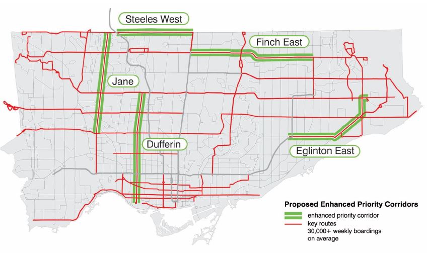
On five other corridors (Jane, Dufferin, Finch East, Steeles West, Lawrence East), there are plans for reserved lanes, although the proposals have not met with universal acclaim. In future articles I will bring the review of their routes’ behaviour up to date. The map below shows the affected routes as proposed in the Service Plan. Lawrence Avenue East was added to this list by the TTC Board.

My underlying premise is that pre-pandemic conditions are a reference point for travel times. Across the entire transit network, traffic congestion and boarding delays fell with the onset of covid. This has been building back gradually, but the effect varies from route to route. There are also external events such as the LRT construction on Finch Avenue West that affect intersecting streets. Finally, the transit red lanes were introduced concurrently with two other changes: the removal of some local stops and the restoration of express service.

This makes identification of the actual cause of shorter travel times more difficult to isolate, and the answer is probably “all of the above”. Each street and route is different, and the benefits, such as they are, of the red lanes should not be assumed to apply on every route segment in the city.

A concurrent issue for transit riders is the dependability of service. It may well be that five minutes is shaved off of their journey with a reserved lane, but if the service is erratic and the wait time for a bus is unpredictable, this benefit can be sabotaged. The situation is further complicated by a mix of local and express buses. If an express can serve a rider’s planned trip, it might save time thanks both to the red lanes and to the fewer stops enroute. However, if the likely wait for an express bus exceeds the time saving (and desire for certainty), a local bus could prove “faster” if it shows up first.

The TTC forever talks about optimization of service and schedule adjustments to make things work better. Problems should be “solved” with schemes like reserved lanes and express buses, so they say. However, headways (the time between buses) continue to be irregular leading to rider frustration and complaints, some of which are due to overcrowding caused by irregular service.

The TTC is good at getting the City to make changes to roads to “improve” service, but not so good at managing the service it has.

The short version of this article is that the red lanes on Eglinton/Kingston/Morningside improved travel times somewhat although we have not yet seen the real test of whether they prevent a return to pre-pandemic, pre-red lane conditions. The benefit varies from route to route, time of day, and day of the week. In spite of the claims that transit priority would lead to more reliable service, gapping and bunching remains a problem on most of the route using the red lane corridor.

This is a key issue for expanding the program: transit priority on its own does not guarantee regularly spaced and, by extension, evenly loaded vehicles.

A Note About Data

Since the idea of the red lanes first appeared, I began to collect data on the proposed routes. This was complicated by a few factors:

  • The red lanes, aka RapidTO, were proposed in the Service Plan issued in December 2019, before the pandemic. In anticipation of studying their benefit, I began collecting vehicle tracking data for the affected routes in 2020.
  • In some cases, because I was already tracking major routes, I had data from April 2018, but there is a big gap until late 2019 because this was the conversion period from the old CIS tracking system to the new Vision system. Data extracts were not available from Vision until late 2019. Therefore, I have very little pre-2020 data that is recent enough to be used for comparison.
  • With the effects of the pandemic on traffic and riding levels in 2020, the travel times are no longer representative of worst case conditions. A silver lining is that for the period when traffic was very light, this gives a best case situation for transit travel, in effect setting a bound on the improvement we could expect if we could just make the traffic disappear.
  • Almost all 900-series Express routes were dropped in Spring 2020, and they have only slowly been returning (more are planned later in 2021 or early 2022 including a few new routes). Therefore an express-vs-local comparison is not available on all corridors.
  • Before the Express network existed, express trips (typically the “E” branch of a route) ran with the same route number and their data are mixed together with the local trips. It was not practical to attempt to fish the express trips out of the tracking data in part because local and express runs did not always make their trips as scheduled, and this varied from day to day. Some buses alternated between making express and local trips. Therefore, data from 2018 represent a mix of times for local and express trips. This understates the time needed for local trips and overstates the value for express trips.

I will not burden the reader with a discussion of the methodology for converting CIS and Vision data to the format used in my analyses. There are two articles on this:

Continue reading

GO Expansion Don Valley Layover Update

On June 24, Metrolinx held an online consultation session for its proposed Don Valley Layover. I wrote about this on June 27 in Metrolinx’ Ill-Considered Don Valley Layover. This article is an update based on that session.

There have been many Metrolinx consultations recently, and a few common threads appeared sitting through this many hours of their presentations and Q&A sessions. Some of the frustration with Metrolinx comes from the way they present material, and from what appear to be shifting positions on key issues.

What Is The Don Valley Yard?

As a quick review, this “yard” is in fact a single storage track, the former CPR, now Metrolinx, Don Branch that once connected the CPR mainline at Leaside to Union Station. It is called a yard because the original proposal was for a three track yard south of the Prince Edward Viaduct.

Metrolinx proposes to convert the portion of this line for storage of three trains between the point where the line crosses to the east side of the Don River roughly at Rosedale Valley Road and the high level bridge near the Brick Works. The site is not accessible by public transit, although it is passed on one side by the DVP and on the other by the Don Valley Trail with many cyclists and pedestrians.

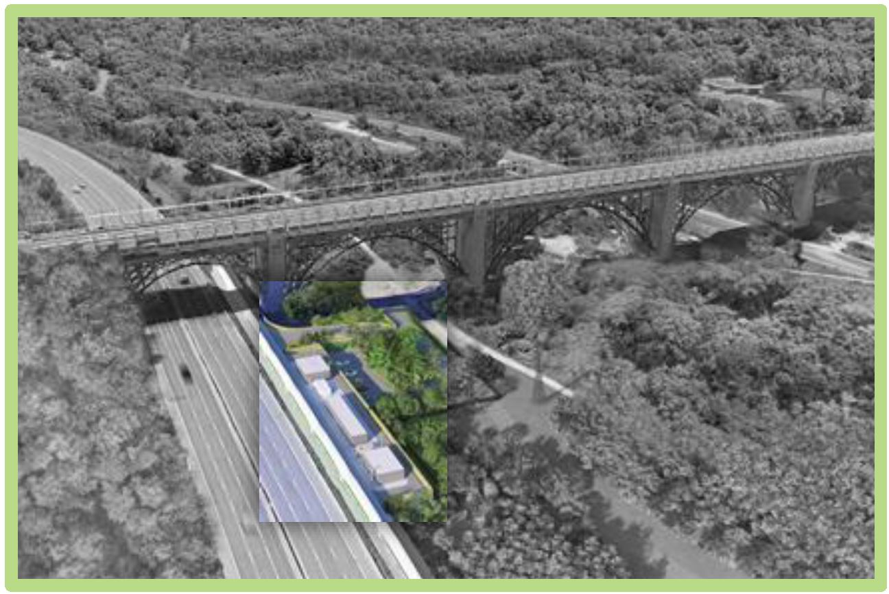
Here is the aerial view.

Metrolinx June 29, 2021 Presentation, p. 2

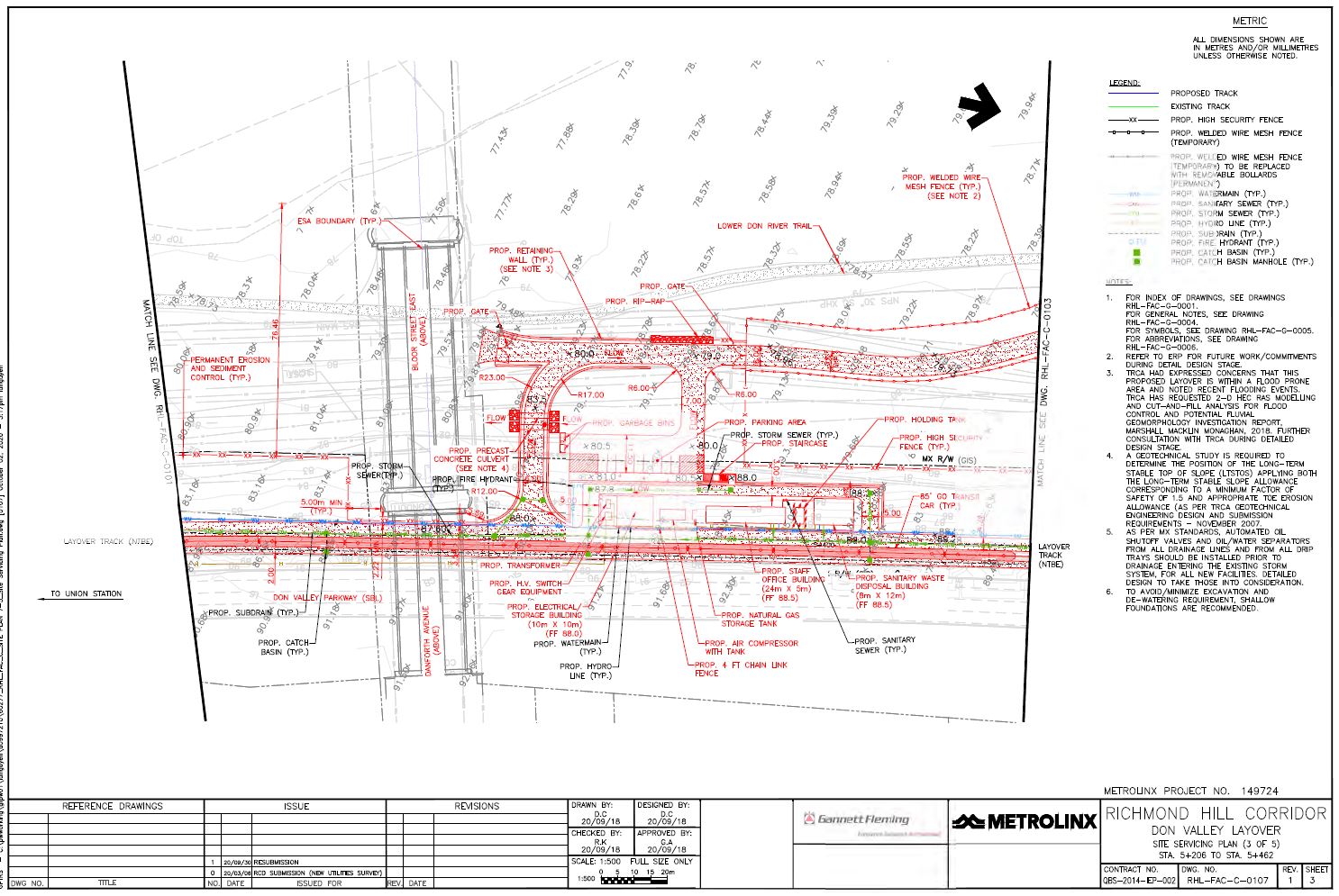
This will require the creation of a service road alongside the track for access to and from stored trains as well as supporting buildings and a small parking lot just north of the Prince Edward Viaduct. The site servicing plan, which includes buildings, roads, utilities and elevations (grey numbers on the diagonal giving the height above sea level in metres) is shown below. The buildings (from south to north) include an electrical building, and air compressor, a staff building and a sanitary waste building.

Click for a higher resolution image.

The valley floor rises gradually to about 80m at the western edge of the Metrolinx site, but the roadway linking the buildings is at about 88m. The parking area shown is on the valley floor, but there is a ramp for vehicles up to the level of the rail corridor. There is also a stairway from the parking up to the staff building. The land owned by Metrolinx is outlined in a broken black line “— – –”. Because of the change in elevation, a retaining wall (yellow in the aerial view) at least 8m high will be required except adjacent to the rail line.

The claimed purpose of the facility is to store three trains between the AM and PM peak periods and, possibly, to perform some light servicing on them. This does not align with the original proposal that clearly talked of a 7×24 operation with three shifts of staff. That might have been an error, a cut-and-paste job from one layover site to another, but the traffic study does speak of arrivals and departures corresponding to shift changes well outside of the midday period.

In any event, there is no provision in the plan for fuelling and Metrolinx claims that they intend to operate here only between the peak periods. We shall see.

Continue reading

Ontario Line North Segment Update

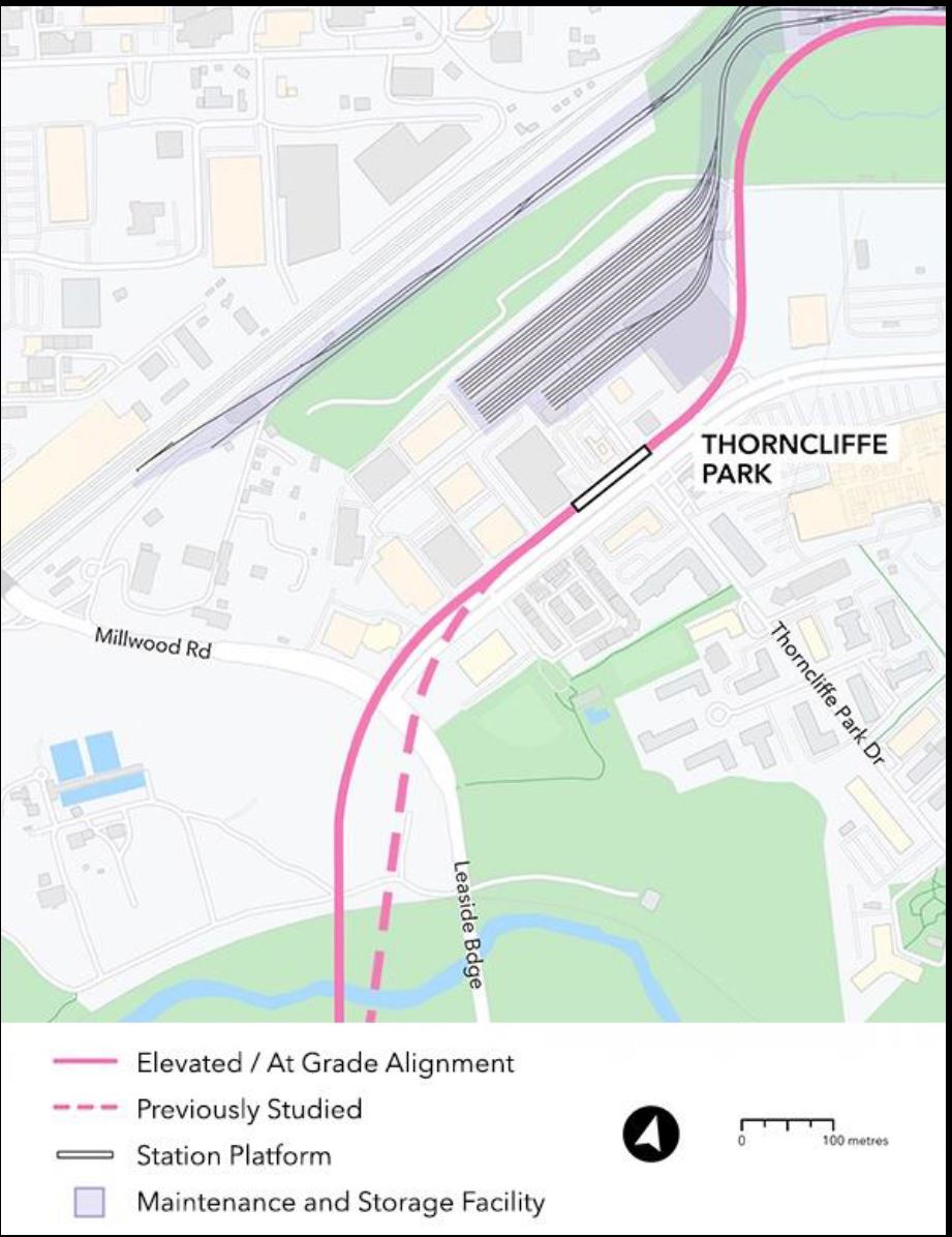
On June 30, Metrolinx held an online consultation for the North Segment of the Ontario Line between Gerrard and Science Centre Stations. Much of the discussion focused on plans for the Maintenance and Storage Facility at Thorncliffe Park.

The presentation deck and video of the session are available for those who want to review the whole thing.

The agenda for the meeting called for a half-hour presentation from Metrolinx, but they ran over by almost double. To their credit they kept the meeting going until they had run out of questions from the online audience.

Since the previous update, there has been a minor change in the alignment near Millwood and Overlea. The Don Valley crossing has been shifted slightly and the entrance to Thorncliffe Park moved to the north side of Overlea Boulevard. This is simpler to build because only Millwood must be crossed, and it moves the structure further away from residences on Leaside Park Drive.

The alignment east of there including the MSF layout is unchanged.

Continue reading

The Richard F. Glaze 16mm Film Digitization Project

Long-time readers of this blog will know that I do not post commercial pitches here. Lots of people have things that they want to sell, but that’s not what my site is about.

Here is an exception.

Richard F. Glaze was a visitor to and later resident of Toronto for decades. He started shooting photographs and film of the TTC while I was still at the “look, a streetcar!” stage my evolution. He was a crusty guy who would show up on fantrips, and our paths would cross socially from time to time.

About 18 months ago, Richard’s vast collection of slides and six hours of colour film were passed on to James Bow who many will know for his site Transit Toronto. Images from Richard’s collection have appeared regularly there as James worked his way through scanning the collection.

The film material is another matter, though, and it requires professional handling for cleaning, high quality scanning, colour and exposure restoration. To that end James has mounted a Kickstarter campaign in the hopes of funding this work. The short term goal is $6,900, and this will pay for about one quarter of the work.

For those interested in the preservation of Toronto’s transit history, this is a worthy goal. You can visit the Transit Toronto website where there is a sample of restored video (streetcars on Rogers Road) and a link to the Kickstarter page. The cutoff date for the campaign is July 16, 2021.

Richard’s photos appear in many places on the Transit Toronto site, but there is a small selection and brief bio here.

To whet your appetite, here a few shots taken from Transit Toronto’s site.

Glen Echo Loop with a regular service car (3010) and a fantrip (2528) signed utterly inappropriately for the location
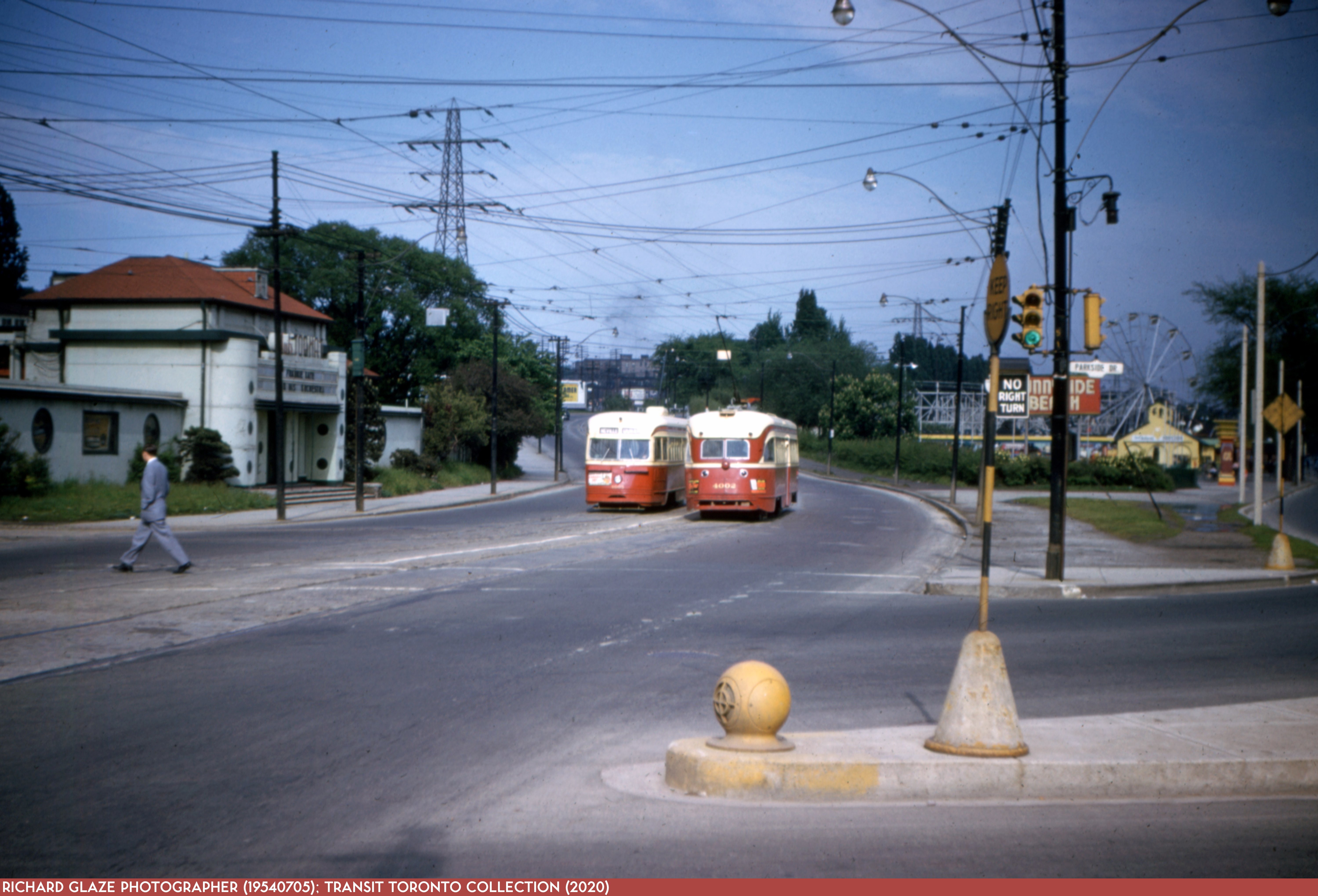
Lakeshore Road at Parkside Drive looking east to Sunnyside Amusement Park. The Gardiner Expressway doomed all of this.
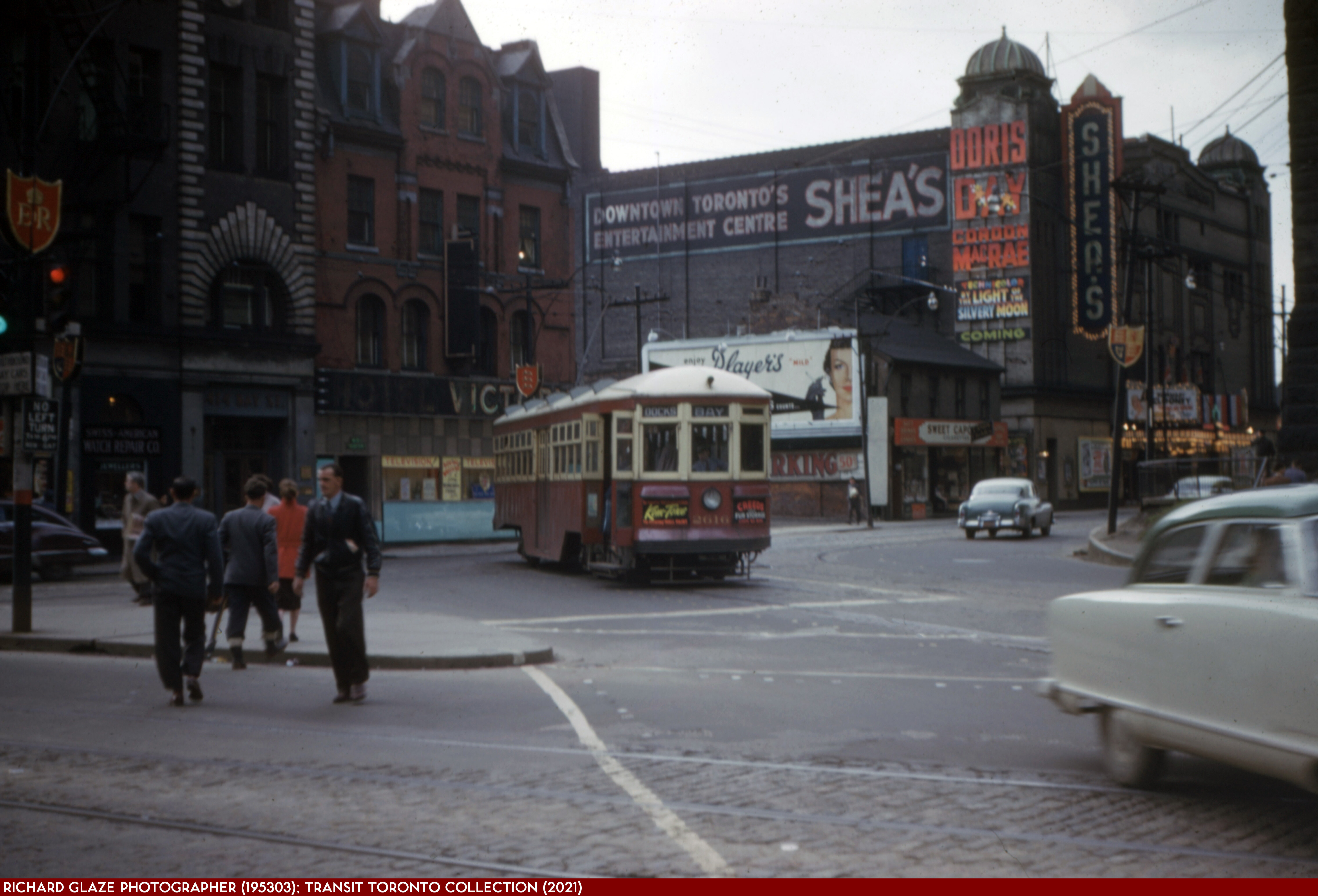
Queen and Bay looking northwest. Today New City Hall would be in the background. Street decorations anticipate the coronation of Elizabeth II.

What Bus Service Will Replace the SRT?

In about two years, July 2023, the Scarborough RT will shut down and be replaced by bus services until a Line 2 Scarborough Subway Extension opens in 2030. For seven years or more, riders will use buses to reach Kennedy terminal on Line 2, a change that will strain both the transit service and roads.

The TTC has a survey underway to July 16, 2021, to find out how riders think the bus service should operate, and to get a sense of how they use the bus network today.

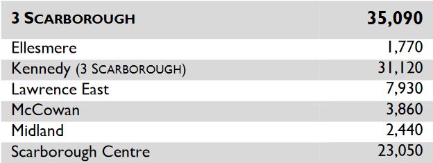
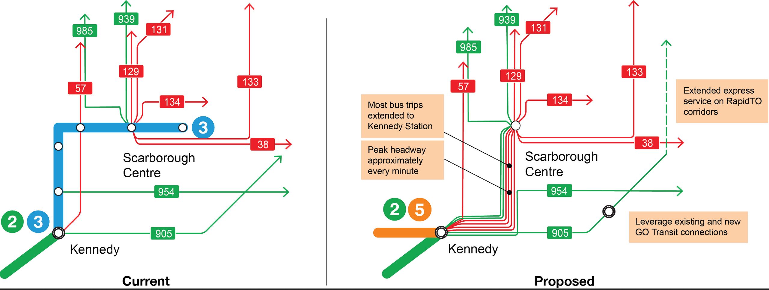
The SRT operates primarily as a link between Scarborough Centre (aka STC) and Kennedy Stations with Lawrence East Station in a distant third place mainly because of transfer traffic from the 54/954 Lawrence East bus services. A replacement service does not have to duplicate the route of the SRT, but rather serve travel patterns between the major nodes.

Source: TTC Subway Ridership 2018

The TTC plans to extend many routes now terminating at STC to Kennedy, but the challenge lies in the route that they will take. The combined service at peak will be about 1 minute, and that will strain road capacity. A saving grace is that buses will not stop often, and so they will not queue at curbside, but this bring an operational challenge for any mixture of local and express services. A reserved lane works best if buses do not have to pass each other by merging into other traffic.

Continue reading

Metrolinx Gives Toronto the Finger, Twice

On the Toronto Executive Committee agenda for July 6, there is a report updating Council on the status of various rapid transit projects in Toronto. Notable by their absence are the Waterfront East LRT (study in progress as previously reported) and the Eglinton East LRT extension.

The truly galling part is found in two letters from Metrolinx, compounded by the abject parroting by City staff of Metrolinx creative writing in the City’s own report.

The documents are linked here:

  • Update on Metrolinx Transit Expansion Projects –Second Quarter 2021
  • Letter from Karla Avis Birch, Chief Planning Officer, Metrolinx, to Derrick Toigo, Executive Director, Transit Expansion Division, City of Toronto re the Ontario Line alignment
  • Letter from Phil Verster, CEO of Metrolinx to Derrick Toigo re the Ontario Line Maintenance and Storage Facility in Thorncliffe Park

The fundamental problem is that Council asked Metrolinx to consider alternatives to their design for the Ontario Line in Riverside (East Harbour to Gerrard Station) and in Thorncliffe Park (the location of the line’s storage yard).

Metrolinx chose to reply with analyses of options that were not those of concern to Council that addressed proposals from the affected communities. What Metrolinx did do was to trot out analyses of previously rejected options as if this somehow validated their position.

To give the impression that Metrolinx has “responded” to the city is a misrepresentation of what has happened, and it suggests that City staff in the Transit Expansion Division are more interested in buttressing Metrolinx’ case than answering Council’s request.

Continue reading

Metrolinx’ Ill-Considered Don Valley Layover (Updated)

Metrolinx will be holding an online consultation on Tuesday, June 29, for its Don Valley Layover scheme. There is a lot of misinformation on this proposal coming from Metrolinx, but as with so many of their schemes, they are bulling ahead.

Full disclosure: I live immediately adjacent to the proposed storage and servicing facility on the east side of the Don River north of the Prince Edward Viaduct. I have a direct interest in the effect of Metrolinx plans and the effect they will have because of the potential for noise and light pollution.

First, it is important that readers understand Metrolinx plans and the supposed function of what they wish to build.

Updated June 29, 2021 at 8:00 am: Additional drawings regarding sound level measurements have been added as well as a commentary on peak versus averaged sound levels.

GO Transit New Facilities

The plans are part of the GO Transit New Track and Facilities scheme which includes new layover yards in various locations around the system. This plan already has Ministerial approval and could proceed at any time to detailed design and construction.

GO Transit plans two new facilities in what they broadly refer to as the Richmond Hill Corridor. The purpose of the two are sometimes confused in Metrolinx presentations with the result that the debate becomes tangled thanks to one plan’s being confused with the other.

As the corridor leaves Union Station, it runs along the north edge of the rail embankment and then swings north along the west side of the Don River. This corridor actually contains two separate railways as they then were.

  • One is the former Canadian National Bala Subdivision. This takes a meandering path north and is owned by Metrolinx to the point where it crosses the CN York Subdivision, the east-west freight route parallel to Highway 7. North of that junction the line is still owned by CN. The Richmond Hill GO service uses this route.
  • The other is the former Canadian Pacific Don Branch which linked Union Station to the CPR’s main line at the former Leaside Station. The line was abandoned decades ago for rail service, but it was bought by Metrolinx. It splits off from the rail line on the west side of the river roughly at Rosedale Valley Road, crosses to the east side, and runs beside the DVP to Pottery Road where it crosses on a high bridge.

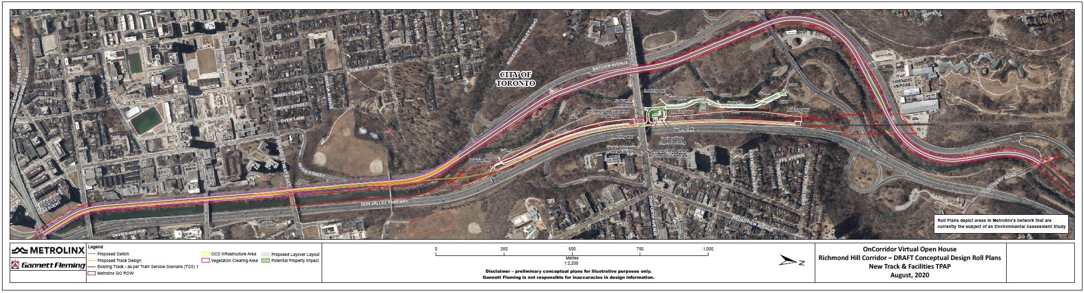
The map below shows the corridor from the south end of the Don River (left) to Pottery Road (right). (For a high resolution version of this plan, click here.)

Continue reading