504 King Cars Returning to King Street (Updated)

After a long absence courtesy of a shutdown of the King Street branch of the Queen/Don Bridge, streetcars will return to King east from Parliament to the Don on Friday, June 5. This will put the 504 King and 503 Kingston Road Tripper cars back on a route they have not seen since mid-2013.

Construction under the Don Bridge of infrastructure to support the development of West Don Lands undermined the bridge foundations which, as it turns out, are wooden piers. Infrastructure Ontario, the agency in charge of the overall project to build the Atheletes’ Village in the WDL, has claimed that King Street would reopen at several possible dates going back to fall 2014.

This will also mark the first streetcar traffic over the new intersection at Sumach Street that leads south to Cherry Street, the WDL and the Distillery District. That line is expected to begin service in Spring 2016 when new residents start moving in to the neighbourhood. The TTC has not yet announced what route structure will be used to serve Cherry south to the loop at the rail corridor (just north of the old Cherry Street Tower).

A comment left by a reader in another thread adds a few details:

503/504 service will be restored on King St. East between Parliament St. and Queen St. East at 5 AM June 05 2015. The city and its contractor (Aecon) have completed repairs and the TTC has replaced the trolley wire. Test streetcars have already been conducted with good results. The TTC will be posting at stops and on web site of changes, as well as having alternate duties employees at the affected Queen St. East stops to advise customers of the restoration of service. (nfitz will be very happy)

Updated June 5, 2015 With Photos

The century-old housing that provided a backdrop for diverting King cars on Parliament will soon disappear under yet more new condominiums.

Meanwhile, down on King, the landscape has changed a lot since the 504 last plied these rails. The black building is a new condo while the brown one across the street, with a Tim Horton’s that has been busy from the day it opened, is a new Toronto Community Housing building.

At Sumach, the new intersection leads south to track on Cherry that will be activated in Spring 2016 when new condo residents move in to what is now the Pan Am Games Athletes’ Village.

Queens Quay Two Way Traffic Begins

On Monday, June 1, the transition to the “new” two-way operation of Queens Quay started with conversion of the traffic signals at Bay Street to their new configuration. This work will progress westward with one intersection a day until June 10.

The new traffic controllers are supposed to have much more sophisticated transit priority provisions than are used elsewhere in Toronto, and their ability to speed up operations on the streetcar right-of-way will be interesting to watch. I have already requested vehicle tracking data for May 2015 as “before” information, and the June 2015 data, when it comes, will show the degree to which the new signals actually perform as claimed.

(Existing signals have no transit priority at all. They merely cycle through a standard program which does more to hinder transit vehicles than to help them.)

Work on the overall Queens Quay project is nearing completion in many areas, although visitors may be forgiven for doubting this given the ever-present and shifting construction barriers. The weekly construction notice gives details of the work as it progresses.

Russell Carhouse: Eastern Avenue Reconstruction (Updated November 20, 2015)

Updated Noveber 20, 2015 at 3:00 pm: Track construction at Russell Carhouse is now complete and overhead installation is in progress.

Updated July 28, 2015 at 12:20 pm: Photos of construction work in progress.

Updated July 3, 2015 at 5:40 pm: Photos of construction work in progress.

Updated June 24, 2015 at 5:00 pm: Photos of construction work in progress.

Updated June 6, 2015 at 10:00 am: Photos of Eastern Avenue construction from 1928 provided by John F. Bromley from his collection have been added to this article.

The ladder track at the south end of Russell Carhouse is being completely regraded and replaced in a project that will consume a few months. This is a joint project with the City of Toronto who are replacing a storm sewer that runs along the northern side of Eastern Avenue.

The track will not only be replaced, but it will be separated from a new sidewalk, and the track elevation will be changed to reduce the effect of turning and climbing at the same time into the tracks at the carhouse.

Eastern Avenue will be one lane each way in the new configuration. Because parking is allowed in curb lanes east and west of this area, a two-lane road is all that is needed to handle typical traffic volumes.

EasternAveDesign201506

[Image from the City of Toronto Construction Notice]

Removal of the existing track is, as of June 2, complete. Carhouse operations are more complex than usual with cars having to back into their storage and maintenance locations. Originally, the TTC would have had Leslie Barns at least partly available for storage, but that site and its access track are still under construction.

The original ladder track on Eastern Avenue was further south. The change is visible in these construction photos from 1928 provided by John F. Bromley from his collection.

Updated June 24: Construction work in progress

Updated July 3: Construction work in progress

Updated July 28: Construction work in progress

Updated November 20: Overhead installation in progress

Scarborough Subway Update: May 27, 2015

Updated May 30, 2015: The staff presentation is now available online. Some illustrations from it have been included in the article below.

At its May 27, 2015, meeting, the TTC Board received a presentation from Rick Thompson, the Chief Project Manager for the Scarborough Subway Extension (SSE). This presentation is not yet online.

During the presentation, Thompson noted that the process of winnowing down nine alternative routes for the SSE was nearly complete, and that a report on the three short-listed options would be issued fairly soon.

The original nine proposals included two major groups. The first would see the north end of the line continue east from STC on alignments similar to the proposed Scarborough LRT crossing Sheppard at either Markham Road or Progress. Three routes were proposed to reach the existing SRT corridor:

  • Via the SRT as currently constructed.
  • Via Eglinton and Midland, then swinging back into the SRT right-of-way north of Eglinton (this would avoid reconstruction of Kennedy Station on a north-south alignment).
  • Via Eglinton and Midland, joining into the SRT alignment near the existing Midland Station.

The second group takes a north-south alignment through or past STC and all arrive at Sheppard and McCowan as their terminus:

  • A Midland/McCowan option would swing into the Gatineau hydro corridor south of Lawrence to link northeast to McCowan and then follow the McCowan route north.
  • A Brimley option would travel east on Eglinton, north on Brimley and then swing northeast through STC to McCowan.
  • A McCowan option would follow Eglinton to Brimley, then swing north via Danforth Road to McCowan. This was the original proposal approved by Council.
  • A Bellamy option would follow Eglinton to Bellamy, turn north, and then swing back to the northwest to reach the McCowan/STC station.
  • A Markham Road option would follow Eglinton to Markham Road (although the exact alignment east of Bellamy is unclear), then turn north and eventually back west to McCowan. This is the most roundabout of the possible routes.

SSEOptions201505

Events overtook the plans, and a report on the shortlisted options that had gone privately to Councillors made its way into the media. The Star’s Jennifer Pagliaro reported that the three remaing options were the original McCowan alignment, the Bellamy alignment and the Midland route running straight north to meet the SRT corridor.

ci-scarborough-subway-routes-shortlist-web

[Toronto Star, from City of Toronto]

Continue reading

Another Delay For Leslie Street (Updated August 7, 2015)

Updated August 7, 2015 at 6:00 pm: Leslie Street will reopen to traffic using the completed streetcar lanes and the west curb lane on August 8. Work will continue to rebuild the east curb lane and sidewalk.

Updated July 28, 2015 at 12:30 pm: Recent construction photos added.

Updated July 17, 2015 at 2:10 pm: Recent construction photos added.

Updated June 24, 2015 at 5:00 pm: Recent construction photos added.

Updated May 28, 2015 at 2:00 pm: Further information about the design of the track support structure has been added at the end of the article along with historical links.

The seemingly endless work to rebuild Leslie Street south of Queen as the access route to the new Leslie Barns hit another setback with the discovery that a section of track was installed at the wrong elevation. This affects the road profile, drainage patterns and the access to an adjacent condo where residents had expected they would be free of side effects beyond the nuisance of construction.

A surveying error by the contractor, Pomerlau Construction, who have responsibility for the entire Leslie Barns project, caused about 60m of track just north of Eastern Avenue to be installed roughly 9cm above the correct level.

To explain a bit about the structures involved, here are photos from the Leslie Street project.

Continue reading

The Lord Mayor Giveth, and the Lord Mayor Taketh Away (Updated)

Updated June 2, 2015: Mayor Tory has sent a letter to his Budget Chief, Councillor Gary Crawford, outlining his goals for the 2016 budget. This includes a better explanation of the two percent goal for budgetary efficiencies, and a

Find at least 2 per cent in savings across all City agencies and divisions. We need to take a determined, practical, business-like approach to eliminate the inefficiency marbled throughout government. This isn’t just about saving money. It is about using our resources responsibly so we can provide better services to the people of Toronto.

Continue investing in transit to cut congestion and gridlock. Transit connects people to jobs. It provides a means of getting around for people who can’t afford a car. As we continue to work towards building longer-term projects like SmartTrack and Scarborough Subway, we must continue to improve and expand services to reduce transit congestion now.

Finding efficiencies and improving transit are not mutually exclusive, but the ever-present problem with transit budgets is that just to “stand still”, to provide the same quality of service to a growing ridership base, costs about 5% in added costs each year. The number could even be higher but for the TTC’s inability to improve peak service.

Meanwhile, the TTC’s CEO Andy Byford said at the recent Board meeting that he would not cut front line services. How both the TTC and the Mayor plan to reconcile competing goals remains to be seen.

The original May 26 article follows below.

Continue reading

TTC Proposes Service Restorations and Expanded Blue Night Network (Updated)

The TTC Board will consider two reports at its meeting on May 27, 2015 relating to service improvements announced jointly by TTC Chair Josh Colle and Mayor John Tory on May 24, 2015.

Most of the 2011 service cuts rammed through by former Mayor Rob Ford and former Chair Karen Stintz will be restored. The “greater good” of the system, a phrase beloved of Ms. Stintz, clearly no longer includes slashing transit service.

One rather contorted paragraph in the report gives an insight into the process by which routes got on the 2011 list:

The use of the productivity standard of boardings per service hour, commonly used throughout the transit industry, began in 2011 at the TTC. It was first used to identify the services that were recommended for removal as part of the budget cuts in that year. The standard used at that time was 15 boardings per service hour or, in some cases where there was a long walk to alternate service, the standard was reduced to ten boardings per service hour. For 2015, the boardings per service hour standard has been continued, but at the lower, currently-affordable level of nine boardings per service hour. The calculation of boardings has also been simplified, and now counts all customers on the entire route or branch section, as appropriate. Previously, a more-detailed and labour-intensive evaluation was used to try to separate and weight differently the boardings that would be made at unique stops, at stops with intersecting routes, and at stops along common sections of multiple routes. The new, simplified method of counting substantially all passengers is simpler to apply and understand, and allows the threshold level to be lowered.

In other words, the 2011 evaluations didn’t actually count passengers, but applied a formula and process to determine which routes made the cut. It is no wonder that some riders and Councillors were baffled to see routes with real live riders, but be told that there were not enough of them.

One oddity is that Kingston Road 12B and 12C (the branches that do not serve Variety Village) will not be operated at late evenings. However, the proposed all night service on Kingston Road will take the 12B/C path and bypass Variety Village leaving a gap in service between early evening and overnight service.

Details of the changes are in the report.

RestoredService_201509

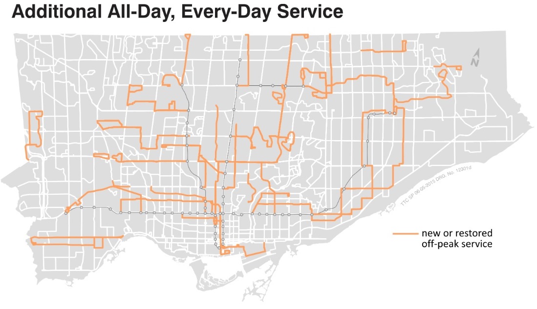
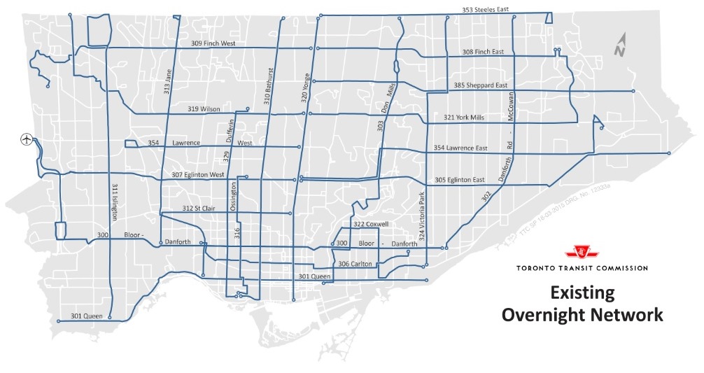
Several routes will be added (and a few restored) to the Blue Night Network. This will fill in many gaps and address service in areas where there is potential demand. In a few cases, existing routes will be modified to simplify their layout and bring them more into consistency with daytime routes.

  • The King night car will be restored. Because this includes service on Broadview and on Roncesvalles where there are already night buses, the following changes will also occur:
    • The Jane night bus will operate straight south on Jane to Jane Station rather than southeast via Dundas and Roncesvalles to The Queensway.
    • The Don Mills night bus will operate straight south over the same route as the daytime Pape bus to Eastern Avenue rather than southwest via Danforth and Broadview to Queen.
    • The St. Clair night bus will take over service on Dundas between Jane and Dundas West Station.
  • The Bloor-Danforth night bus will be extended to Kennedy Station via Danforth Road and Eglinton.
    • The Danforth-McCowan night bus will be rerouted at its south end to serve Kingston Road from Brimley to Bingham Loop.
  • The Lawrence East night bus will operate to Starspray replacing the Eglinton East night bus.
    • The Eglinton East night bus will operate north to Malvern taking over the outer end of the existing Lawrence East and York Mills routes.
    • The York Mills night bus will operate east and north via Meadowvale to Sheppard.
  • All night service to York University will be provided by the new Keele night bus, and by extensions of the Jane and Steeles night buses.
  • The Steeles night bus will be extended east and south to a common terminus in Malvern with the Finch East and Eglinton East night buses.
  • Service on Lawrence will be extended west to the airport and east to Sunnybrook Hospital.
  • The Dufferin night bus will be extended north to Steeles.
  • New all-night services will be added on Sheppard West, Spadina to Union Station, Parliament, Kennedy, and on a night version of the Evans bus that will connect to Long Branch Loop.

Details of the changes are in the report.

Note that the extension of 353 Steeles to York University has already been scheduled to occur on June 21, 2015 in anticipation of the Pan Am Games at York University..

One important aspect of the very old night service network, probably remembered by only a few old hands, is that there were published schedules for major stops and timed connections where possible between routes. This was lost when the Blue Night network was created decades ago, and the TTC would do well to restore accurate information and more rigourous operation of the night routes. The quarterly performance measures are particularly bad for the night routes, a serious problem for people attempting to travel when 30-minute headways can play havoc with trip planning.

BlueNightService_201505

BlueNightService_201509

The Evolution of Service on 512 St. Clair (2) (Updated)

This article is a follow-up to an early April review of the gains and losses brought by the St. Clair right-of-way and subsequent “transit priority” measures. When it was published, the TTC had just changed schedules on this route to shorten trip times in response to repairs on several traffic signal locations where that “priority” function was not working. Did these repairs actually have an effect? How well did the line operate with less running time?

Updated May 23, 2015 at 12:40 pm:

Data for weekend operations has been added to the end of this article.

Conclusions

  • There was a definite increase in travel times in fall 2014 as compared with summer 2010 when the right-of-way operations west of St. Clair West Station began. The location and severity of the problem varied along the route with notable effects between Bathurst and Oakwood where there are many traffic signals.
  • The amount of running time added in the October 2014 schedules was slightly more than the actual increase in average running time over the route from 2010 to 2014.
  • Travel times were reduced after the repair of transit priority functions at several signals along the route, notably in sections with many traffic signals. This did not completely reverse the longer running times of 2014.
  • Short-turns as a proportion of all service declined with the new schedules in place.
  • The increased supervision produced more reliable headways.
  • The improvements of October 2014 have been slightly reduced with the new April 2015 schedules that clawed back much of the additional running time.

For reference, here is a table from the first article showing changes in schedules for the route since 2007.

512_ServiceHistory

Generally speaking, the April 2015 changes reduced one-way running time by 6 minutes during most periods with a few, minor adjustments to terminal “recovery time”. Those “recovery” values are as much a rounding factor to make the headway  come out to an even value as they are a calculated amount of time needed to deal with random delays.

Continue reading

The Evolution of Service on 29 Dufferin: Weekdays 2011 to 2015

29 Dufferin is one of the TTC’s target routes for improved performance, and it also happens to be a route that I have been following with TTC vehicle tracking data from selected months going back to November 2011. This article reviews the line’s operation on weekdays.

This article is somewhat technical, but has been written for a general audience to the degree the subject allows.

Scheduled Service History

An important factor in reviewing service on the street is the schedule itself: the headways (time between vehicles) and the running times provided for each trip. Headways may look good on paper, but if service arrives unreliably, or if some of it never reaches the destination thanks to short turns, then the advertised service is a polite fiction. Running times also have an effect, especially if they are shorter than the typical time required to drive from one end of a route to the other. When an operator cannot make the scheduled trip, the bus runs late and is quite likely to short turn simply to get it back on time. In theory, this “restores” normal service, but if vehicles are chronically late, the process never ends. The “treatment” never cures the “patient”.

The months included in this article are:

  • November 2011
  • March 2012
  • May 2013
  • September 2013 (Dufferin Bridge at CNE closes)
  • March 2014 (Diversion from College to Queen southbound for water main construction)
  • November 2014 (Introduction of articulated buses)
  • April 2015 (Major schedule revisions to reflect actual operating conditions)

29_ServiceHistory

This spreadsheet shows the scheduled headways and trip times for all of the periods covered by this article. In a few cases, there are two schedules shown for the same month because a change was implemented part way through.

The Dufferin Bus operates primarily between Dufferin Loop (at the Western Gate of the CNE ground) to Wilson Station. During peak periods there is a short turn at Tycos Drive where half of the service returns south. During certain periods (with seasonal variations), half of the service runs through the CNE grounds to the Princes’ Gate (eastern entrance).

In September 2013, the bridge on Dufferin at the rail corridor north of the CNE closed on very short notice for repairs. Service that was scheduled to operate to the Princes’ Gates turned back at Dufferin Loop. This resulted in half of the buses having more running time for their trips between Dufferin Loop and Wilson Station. Concurrently, a diversion for water main construction was operated southbound between College and Queen. These two offset each other, at least for the buses that were scheduled to run through to the Princes’ Gate. Extra running time (up to 10 minutes)  was not added to the schedules until the end of March 2014 in anticipation of the re-opening of the Dufferin Street bridge.

In November 2014, the route officially switched to articulated bus operation Weekdays and Saturdays, although these vehicles had been present for some time before.

In April 2014, there was a major restructuring of the schedules: considerably more running time was provided to reflect actual conditions, and the split operation at the south end of the route was discontinued on weekends.

Continue reading