Toronto’s Executive Committee considered a report on the current status of the Eglinton East LRT and Waterfront East LRT projects at its meeting on December 10, 2020.
The primary function of this report is to authorize continued study, not to set priorities nor to discuss funding schemes. As such, its recommendations passed easily because it preserves the convenient fiction of progress without actual commitment. The real battles come when there are $30 billion worth of transit projects and less than $10 billion to pay for them.
In a beautifully ironic touch, the same morning brought news from the Toronto Star’s Jennifer Pagliaro that the Scarborough RT would not last long enough to avoid a shutdown well before the Scarborough Subway could be completed. That announcement raises a raft of questions about Toronto’s transit future that go well beyond Scarborough itself, and I will turn to those issues in a separate article.
The Toronto Region Board of Trade recently published a discussion paper on the subject of regional transit integration focused on fare structure and the barriers it creates to regional travel.
This is to be the first of four papers with others to follow on subjects such as increasing utilization of the regional rail network and improving service on the local bus networks around the GTHA. No publication dates have been announced for the remainder of this series.
The absence of those papers leaves the first one on fare integration out on its own missing some of the context that drives choices of what might make an appropriate “solution”. In particular the key roles of both GO Transit and local transit systems, or at least as the Board of Trade might see them, inform the proposal of a new fare structure, but more as background. Are these assumptions valid and does a new tariff based on them actually stand up to scrutiny?
Schemes to unify the regional fare structure have floated around the GTA for years. Lots of ink was spilled on reports, models and consultation. Nothing much has actually happened, or at least that’s the impression one might get, in part because different players have different goals.
Metrolinx is absolutely wedded to a zone fare system because that is how their fare collection technology works. They speak of it as “fare by distance”, but their zonal structure contains many inequities because it evolved piecemeal along with their network. Long trips are cheaper than short ones, measured in cost/km, both to discourage short-haul riding and to give greater incentives to long-haul commuters to switch from their cars to GO’s trains. Relatively recently, GO introduced reduced short-haul fares so that it could attract more short trips, but the tariff as a whole remains a patchwork.
When Metrolinx first proposed a distance-based regional fare strategy, it had an added wrinkle with a premium fare for “rapid transit” which meant anything on rails on its own right-of-way including the subway. Any trip longer than 10km (slightly above the average trip length on the TTC) would cost more than it does today, and drawing 10km circles around various centres easily shows who would pay more to travel. This had the effect of preserving GO Transit’s revenue stream, while raising the cost of subway travel for longer-than-average journeys.
This was in aid of a “zero sum” solution where the cost of lower fares for riders crossing the 905-416 boundary would be recouped from higher fares within Toronto. Metrolinx showed only a few sample fares to illustrate changes, but neglected to present a thorough review of the effect on TTC riders who are by far the majority of transit users in the GTHA.
In time, Metrolinx, or at least some members of its Board, came to realize that this was not a viable solution, and that any new fare structure would require added subsidy to avoid penalizing one group of riders to reduce fares for others. Alas, nothing official ever came of this.
The regional transit agencies were not sitting still, however, and the now-universal fare model is based not on distance travelled, but on the elapsed time for one or more trips, in effect a limited duration pass. Not only is this scheme easy to understand and administer, it removes a long-standing penalty against riders who took multiple short trips, typically to run errands or stop off in a longer journey just as one would do as a motorist.
Even Toronto, after much foot-dragging, embraced the two-hour transfer when it became politically beneficial. What was once portrayed as an unaffordable fare giveaway morphed into a modest-cost change that greatly simplified fares and improved system convenience. The only remaining gap in this arrangement is the lack of reciprocity across the 416-905 boundary so that a two hour fare can buy rides inside and outside of Toronto.
The odd man out remains GO Transit, a regional, long-haul carrier, an operator of fast trains where two hours would take a rider a far greater distance than on a bus, streetcar or subway. There will always be a conflict between seeing GO as a “rapid transit” line serving local demand as opposed to “commuter rail”. Just to complicate things, GO buses fall somewhere in between because they operate limited stop service with much more comfortable accommodation than, say, the Dufferin bus.
GO faces an additional problem with a penny-pinching master at Queen’s Park for whom spending more money on transit operations (as opposed to capital construction) is not a priority. Even the GO-TTC co-fare was eliminated although it remains in place for GO-905 travel. It is ludicrous that a “first mile” trip in the 905 gets a co-fare subsidy, but not one in Toronto.
Metrolinx has launched another round of consultation for various projects that make up the GO Transit Expansion Plan. Information on these is scattered through various pages on their site.
There is an interactive map of locations where changes are proposed, although it can be tedious to navigate because the default map does not have street names. (You can change this by selecting a different base map from the options in the upper right of the display.)
This map shows roughly the location of the Ontario Line corridor, but gives no detail about extra space, although the map is not to be taken as definitive. Nothing is shown of potential stations for the OL, and there is no information at all in the map for the several proposed SmartTrack stations.
This means that the scope of the project review and the combined effect GO Expansion will have with other projects is not known. Moreover, it would be foolish to approve a project based on a spec that did not include two major additions that are somewhere in the Metrolinx pipeline.
Stations, be they for the Ontario Line or for GO/SmartTrack require platforms and circulation elements (stairs, elevators, roads) but there is no hint of the space these will take.
Updated October 25, 2020 at 9:30 pm: Illustrations have been added or replaced to provide higher resolution versions that were issued as part of the TTC Board Meeting presentation.
Plans for the expansion of Bloor-Yonge Station have reached another milestone with revelation that the project will have some effect on the buildings above and around the subway structure. This was not really a surprise, and some of the structural challenges have been acknowledged in past reports.
For this iteration, however, the need for more platform and circulation space triggered negotiation with affected property owners who may view this as an opportunity to reconfigure their buildings.
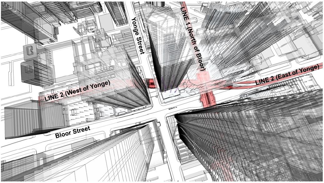
To put everything in context, here is a bird’s eye view of Bloor and Yonge showing the existing subway structure. North is at the top.
Yonge Station lies on a diagonal between, roughly, Bloor Street East and Park Road (the east end of the Hudson’s Bay building) and the northern half of the block on Yonge between Bloor and Cumberland. The building at 2 Bloor Street East (northeast corner) actually sits on an underground bridge because of local ground water conditions and a nearby stream that continues to appear from time-to-time within the station.
The original Yonge line is east of Yonge Street and its alignment is easy to spot from the surface by a succession of parks and parking lots above the subway where once there were buildings.
Source: Google Maps
Before the Bloor-Danforth line opened in 1966, there was a fare-paid transfer station in the middle of Bloor Street where passengers switched between the subway and extremely frequent streetcar service. The problem of moving people between the Yonge and Bloor routes has been with us for a very long time.
A painting of the proposed Yonge Station by Sigmund Serafin from 1957 shows how the then-new Yonge Line would relate to the proposed station on the Bloor Line. Note the red Gloucester cars on the Bloor line. That’s what everyone thought of as a subway train in those days.
[Many decades ago, I rescued this painting and others from a TTC housecleaning binge. It is now in the collection of the City of Toronto Archives Fonds 16, Series 2449, Item 1]
The connections to the streetcar platforms are now walled off, but they were behind a row of fluted aluminum columns about a third of the way down the platform.
The platforms on the Bloor Station (Line 1) level were expanded decades ago to double their width over much of their length, and the east and west concourses were also expanded to provide more circulation space. However, problem remain on the Yonge Station (Line 2) level where a single centre platform is shared by both directions. It is often crowded and can be dangerous when service is suspended.
The map below shows the site and the degree to which the structure will be expanded. Most of the new construction will be under Bloor Street but some will be under existing buildings on the northeast corner of the Bloor-Yonge intersection. Exactly how this will affect the buildings is unknown because details of the property agreements are in a confidential appendix to the report.
The important point about this land is that it is still owned by the City and is leased. The expanded station will require changes in the lease arrangements.
On Line 2, a new platform will be added south of the existing structure. This will separate eastbound and westbound passengers. The new platform will have its own connections to the upper level into expanded concourse areas, as well as a link to the exit onto Yonge Street at the west end of the station.
Also shown in the diagrams below are new fan plants (red). These are required to improve emergency ventilation at the station and bring it to current fire code.
Updated October 25, 2020: A second version of the plan has been added below (the “Concept Design”) from the presentation to the TTC Board. It is at higher resolution and gives a better site context. Figure 3 from the original report has been left here because it contains notes that are not in the presentation version.
At the north end of Bloor Station, the circulation space will be considerably increased and there also be new elevators linking the east and west concourse areas to the two Yonge Station platforms below.
Not shown in either the report nor the presentation materials is the layout for the fare control area one level up from Bloor Station. This will necessarily be affected both by the relocation of stairs, escalators and elevators, as well as by whatever changes might occur in the mall outside of the station itself.
This project is fully funded with contributions from Toronto’s City Building Fund, as well as the Provincial and Federal governments at a total cost of $1.5 billion. Design is expected to reach the 30 per cent level in mid-2021 for project approval. Final design would be completed in 2023 with an aim for the construction contract award in 2024. The completion date of 2029, before the Richmond Hill extension opens, drives the overall schedule for this project.
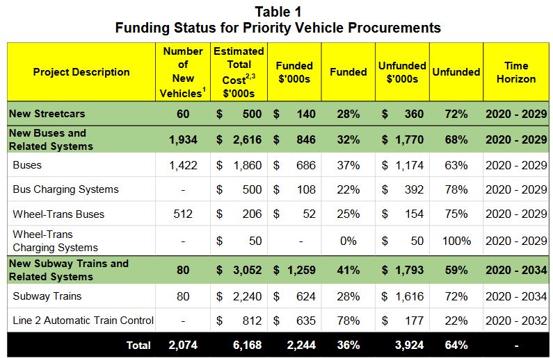
At its meeting on October 22, the TTC Board will consider a report setting out plans to purchase new buses, streetcars, subway trains and Wheel-Trans vans in coming years.
In an important departure from typical practice, the City is setting out its position including what can be achieved with already-committed City funding without waiting for confirmation of contributions from other governments. Both the provincial and federal governments will face voters sometime in the next few years, and this, in effect says “come to the table”.
The plan has many strong points although some important details are missing. Key to this plan is that it is a system plan, not a scheme for one tiny chunk of the network nor a flavour-of-the-day announcement from one politician.
Overview
The TTC proposes acquisition of hundreds of new and replacement vehicles over the coming years:
From 13 to 60 new streetcars from Bombardier to be delivered between 2023 and 2025.
Approximately 300 hybrid-electric buses for one or both of the two qualified suppliers to be delivered between 2022 and 2023.
Pending outcome of technical evaluation and product comparison work now underway, approximately 300 all-electric long-range buses in 2023 to 2025.
70 Wheel-Trans buses for delivery in 2022 and 2023.
80 subway trains to replace the existing fleet now used on Line 2 and to provide for future service improvement with ATC (automatic train control).
That list is only part of a larger scheme shown in the table below.
The “ask” for funding on these projects is based on the full quantity of vehicles (column 2 above) as opposed to what the TTC can achieve with only the City’s contribution (column 3).
A political problem for the TTC is that they are seeking funding for the ten year plan within the next few years even though some of the spending is in the latter part of the decade.
For example, the buses are unlikely to be contracted on one big purchase that would lock in a single supplier, and a new contract would be tendered two or three times during the decade. Similarly, the quantity of Wheel-Trans buses represents far more than one fleet replacement (as of June 30 there were about 280 WT buses). Part of this funding would not be required until late in the decade when the next purchases would be at end-of-life.
Commitments that far off are unlikely to be made by either the provincial or federal governments both of which would face at least one if not more elections in the meantime.
A further issue is that there are many more projects in the TTC’s long-range capital plan than the ones listed here, and there is no sense of relative priority for things like ongoing infrastructure maintenance. If the vehicles program soaks up all available funding, other projects could find that the cupboard is bare.
Missing from this report is an overview of the cash flow requirements for each project and the point at which money for each component must be secured. Projects with long timelines such as ATC installation need early commitment even though they would not finish until late in this decade or possibly longer. The same does not apply to the cyclic renewal of the bus fleets and some of the associated infrastructure.
TTC footnote 1: Estimated vehicle procurement quantities are based on Class 4 cost estimates. Given the need exceeds the funding currently available, TTC will seek to maximize the final number of vehicles to be procured through negotiation of contract unit pricing.
To support the electric vehicle purchases, the TTC together with Toronto Hydro and Ontario Power Generation (OPG) are working on plans for the charging infrastructure that will be required to move to a zero emissions fleet by 2040 in regular buses, Wheel-Trans and non-revenue vehicles.
The subway train order will likely grow because Metrolinx would piggy-back the needs of the Yonge North extension to Richmond Hill and the Scarborough extension to Sheppard for economies of scale and consistency of fleets on the two major rapid transit lines. However, the cost will be on Metrolinx’ account because these are now provincial projects. There is a danger that if future provincial funding is constrained, the provincial projects could elbow aside requests for local projects.
The committed and required funding amounts are set out below.
TTC footnotes: 1: Number of Vehicles reflects the current fleet plan as described under the Comments section of the report. 2: Estimated Total Costs includes the following: (1) vendor contract payments for vehicle design, production, delivery and commissioning of vehicles; and (2) delivery costs including procurement, project management, engineering, quality assurance, and project contingency 3. Total Estimated Cost has been revised from $5.84 billion (Class 5) to $6.17 billion (Class 4).
The City’s share is provided by the City Building Fund, a supplementary property tax introduced in the 2020 budget, together with funding that had been allocated to a planned rejuvenation of the Line 2 subway fleet for an additional decade of service. Now that those trains will be replaced, the money set aside to refresh the old fleet is available for this project.
City Building Fund Project
$ millions
Bloor-Yonge Station Expansion
$500
Line 1 Capacity Enhancement
$1,490
Line 2 Capacity Enhancement
$817
Line 2 Automatic Train Control
$623
Other Critical Subway State of Good Repair (Note 1)
$160
New Vehicles and eBus Charging Systems
$1,140
Total City Building Fund
$4,730
Note 1: These values do not exactly match numbers cited in the TTC report due to rounding.
The vehicle procurements are funded on the City side by a combination of CBF monies (see above) and the previous allocation for renovation of the Line 2 fleet of T1 trains.
Project
$ millions
80 New Subway Trains
$ 623
T1 Overhaul and Maintenance to 2030
$ 74
Procurement of Buses
$ 686
eBus Charging Infrastructure
$ 64
Wheel-Trans Buses
$ 22
New Streetcars
$ 140
Total
$1,609
Existing Approved Funding (T1 Life Extension)
$ 474
City Building Fund
$1,140
Total
$1,614
Combining the $1.61 billion above with the Line 2 ATC funding brings the City’s total to about $2.2 billion. The TTC and City invite their partners at the provincial and federal levels to make up the difference of just under $4 billion between City allocations and the total required for this portion of the overall capital plan.
The City’s strategy is to start spending its $2.2 billion and hope that the other governments will come in for their share. There are elections at both levels that could provide some leverage, but there are also problems with Toronto’s appetite for capital compared to other parts of Ontario and Canada.
An ongoing problem for anyone attempting to work with Metrolinx on their projects is the lack of transparency, the fog through which details emerge, if at all, on what they actually propose to do.
Distrust of Metrolinx to deal fairly and honestly with communities and their political representatives led to widely-supported motions when Council considered two reports regarding Metrolinx projects on October 1, 2020:
Back in June 2020, I wrote about the gradual drift in the planned dates for various Metrolinx projects as reported by Infrastructure Ontario [IO for short].
The September 2020 Market Update has been issued by IO and it shows changes in some projects from the June update.
Sept 26, 2020: Revised to include the change in financing method for the OnCorr GO Corridor project.
Is The P3 Model Falling Apart?
Two revisions in the large GO project procurement model involve a change from private sector financing to traditional government borrowing.
This suggests that the market willingness to finance projects on behalf of the government, or at least to do so at rates competitive with direct government borrowing, may be on the wane. That implies that the “P3” model may be coming unglued.
At its heart, this was always seen as an accounting mechanism to shift debt off of the government’s books, and without this shell game, a major argument for P3s could vanish.
The Future of Electrification
The change in financing model could shift any decision on propulsion technology back to the government.
Metrolinx had pushed this off its plate by saying that the bidders who were going to design and operate a future GO network would make that choice. This punted the knotty political problem of hydrogen trains touted former Premier McGuinty out of Metrolinx itself.
Will Ontario be willing to finance the large up-front capital costs of electrification itself with so many other pressures on financial resources, or is electrification about to fall out of consideration while spending focuses on service expansion?
Ontario Line
The project is in three sections of which the last will be the “Northern Civil, Stations and Tunnel” which includes the portion of the line east of the Don River and north to Eglinton, but not the Maintenance Facility which is included with the “South Civil” portion as it is needed relatively early in the project.
Some of the work on the North section between the Don River and Gerrard Station might be undertaken as part of the GO Corridor improvements, but exactly what this might entail has not been made public.
Since the last update, there are three changes for the North section:
The date for RFQ (Request for Qualifications) issue has been changed from Winter to Spring 2022.
The RFP (Request for Proposals) issue has been changed from Spring 2022 to Fall 2022.
The Financial Close (in effect, the contract signing) has been changed from Fall 2023 to Spring 2024.
The remaining portions of the line are on the same timeline as before.
The timelines for this project, with financial close for the first two portions in fall 2022 and for the third in spring 2024 puts this beyond the next provincial election expected in mid 2022, the four-year anniversary of the Ford government’s election. Who will be in place to make final decisions, and what the government’s financial position will be by then, remain to be seen.
Line 2 East Extension (Scarborough Subway)
This project is now shown with two portions: one for the tunnel, and the other for the stations, railway and systems.
There is no change in the tunnel portion of the project, but the remaining portion has reverted to the dates shown for the overall project in the Winter 2020 update.
GO Expansion Lakeshore West Corridor
The financial close for this project has been changed from Winter 2021 to Spring 2021.
GO Expansion Lakeshore East-West Corridor
This was originally to have been a “Build-Finance” project, but it is now “Design-Bid-Build”, a change that was made in August 2020 according to the IO report.
GO OnCorr Projects
[Added to this article on September 26, 2020]
This is a very large project including future operation of GO Transit and possible changes in the propulsion technology.
The procurement model has been changed from “DBOFM” (Design-Build-Operate-Finance-Maintain) to “DBOM”. The proponent will no longer finance the project which has a projected value of over $10 billion.
All other projects are unchanged. A summary of the Metrolinx projects tracking their changing status is available in this spreadsheet (revised version).
October 6, 2020: This article has been updated with information on the north section of the Ontario Line between Danforth and Eglinton (Pape to Science Centre).
September 29, 2020: This article has been updated with information on the east section of the Ontario Line between the Don River and Danforth.
September 23, 2020: This article has been updated with information on the central section of the Ontario Line between Osgoode Station and the west side of the Don River.
I asked Metrolinx a series of questions about information released in the two “neighbourhood updates”:
1. The station boxes that are shown are barely 100m long. What provision will the stations include for ventilation shafts? Will they be within the platform area or will they be beyond the end of the platforms as on, for example, the Crosstown line?
2. There is only minimal discussion of entrance locations. Will the stations include two separate paths from platform to surface as per fire code?
3. Will there be emergency service buildings between the more widely spaced stations to provide egress in case of a tunnel fire?
4. There is reference to using the space for lower Queen station as part of the design, but this area is (a) fairly small and (b) already used for a variety of purposes. Is the intent to have the OL go beneath all of the existing structure with the actual track and platform below lower Queen and with the “ghost” station space (which is already used in part as a pedestrian underpass between northbound and southbound platforms) only used for circulation space between the two lines? That would make a lot more sense than actually trying to take OL trains through the existing lower Queen Station.
5. The diagram of the Don Yard shows a direct conflict between the structure for the westbound OL portal and the Richmond Hill GO corridor. What is happening here?
In response, Metrolinx issued the following rather opaque reply:
Metrolinx will factor in all necessary safety and accessibility requirements into the Ontario Line designs. The most recent update is a more detailed vision of the project, but more details are still to come.
Metrolinx will be closely coordinating any Ontario Line work alongside our existing rail operations to minimize or avoid service impacts, while also respecting concurrent GO Expansion work.
Email from Scott Money, Metrolinx Media Relations
The original article begins here:
On September 17, 2020, Metrolinx released the Draft Environmental Conditions Report [Draft ECR] for the Ontario Line.
A huge volume of material is included, thousands of pages, but the vast majority of this only documents existing conditions and gives little indication of the actual “environmental impact” that building and operating the Ontario Line will have.
For convenience, here are links to source materials. The Draft ECR link leads to a page with many documents, some of which are very large PDFs.
It is self-evident that the actual impact of any project cannot be known without the details of what will be built. This information is not yet public and only sample area maps which are drafts “for illustrative purposes only” have been released for a portion of the route. More will follow in coming weeks, but one must ask why they are not all available now if Metrolinx expects informed comment on their proposal.
Even on the supplied maps, many key features are missing including:
Vertical and horizontal alignment including property requirements for construction
Station sites, access and circulation plans including redundant paths between platforms and the surface for fire safety
Emergency service buildings and access structures to tunnels
Utility buildings such as substations
During the public consultation process and as recently as the April 2020 report summarizing this work, the project timeline was illustrated as below. This clearly shows that only one set of “Environmental Reports” were to be published and this was expected in Fall 2020, that is to say, now.
Source: Engagement Summary Report, April 2020, p. 43
Ontario changed the legislation relating to Environmental Assessments with the effect that the item of most interest — the actual design and effect of the project — will not be known until later in the process than the public originally expected.
As required under O. Reg. 341/20, Metrolinx is preparing an environmental conditions report, which will be published for public review and input prior to finalization. The report will characterize the environmental setting in the vicinity of the Ontario Line, including existing noise and vibration levels, air quality, natural environment features, built heritage and archaeological resources, socio-economic and land use features, and traffic conditions.
Metrolinx is also planning to publish early works reports for components of the Ontario Line project that are planned to proceed to implementation ahead of completion of the Ontario Line assessment process.The early works reports will assess the environmental impacts of the early works and describe associated mitigation measures. The early works reports will be published for public review and input prior to finalization.
Following finalization of early works reports, Metrolinx will publish an environmental impact assessment report, which will assess the environmental impacts of the Ontario Line and describe associated mitigation measures. The environmental impact assessment report will be published for public review and input prior to finalization,as part of Metrolinx’s effort to meet the best practices and community consultation principles that are part of the Environmental Assessment Act with all projects. This will be followed by early works reports and the Environmental Impact Assessment Report environmental impact evaluation results, mitigation measures, monitoring activities, potentially required permits and approvals and other components.
Source: Metrolinx Update to City of Toronto, p. 13
There are now three streams of reports and consultation. First up is the ECR which has just been issued, but separately there are reports on “Early Works” (design and construction that can get underway to advance the project before the full design is locked down) and then the “Environmental Impact Assessment Report”. It is only in the last report that the details of design and effects on neighbourhoods will be revealed, and this is planned for winter-spring 2021.
Source: Ontario Line Environment Page
On a parallel track, the procurement process is already underway with teams short-listed to bid on two major contracts:
Rolling Stock, Systems, Operations and Maintenance (RSSOM)
Southern Civil, Stations and Tunnel (Exhibition to Don Yard Portal)
The Northern Civil, Stations and Tunnel package (Don Yard Portal to Eglinton) will be tendered separately in 2022.
The ECR contains material reviewing conditions in a wide study area shown in the map below.
The study area is relatively wide in some areas, but narrower in others implying that a range of options was reviewed for parts of the route. Notable by its absence is the original Eastern-Pape corridor for the Relief Line showing that there was never any intention of entertaining this as an option, if only for comparative purposes.
The study area in Thorncliffe/Flemingdon is fairly large in part because this includes the proposed maintenance yard, but also because alternative routes through this area were under consideration.
Source: Draft Environmental Conditions Report, page i
Alignment plans are shown only for the western segment between Exhibition and Queen/Spadina at this point. Metrolinx plans to unveil details of additional segments on a weekly basis for other parts of the line:
Osgoode Station to Don Yard
East Harbour to Pape South
Pape North to Science Centre (Eglinton)
They have published details for the first segment in a blog article as well as on the West Neighbourhood page (both linked above). I will update this article as information on these segments is revealed.
One burning issue in the third segment is the alignment through and effects on the South Riverdale and Leslieville area between East Harbour and Gerrard Stations. Although details on this have not been published, there is a note in a recent Metrolinx report to City Council (linked above) about the area just north of Queen Street where a recreation centre stood in the line’s path.
The Ontario Line team is working with City staff to ensure the project is delivered with minimal impacts to sensitive community areas and properties, such as parks and community centres. For example, following significant design and engineering effort, the station at Riverside/Leslieville has been positioned to avoid impacting Jimmie Simpson Community Centre. Efforts are underway to minimize impacts to other key community assets, including, Pape Avenue Middle School, Valley Park Middle School, Bruce Mackey Park, the future Ordnance Park, places of worship and other locations. Where an impact cannot be avoided the team will continue to work with City staff to address continuity of programming.
Source: Metrolinx Update to City of Toronto, p. 13
Today, July 21, Toronto’s Executive Committee will consider a report from Barbara Gray, the City’s General Manager, Transportation Services recommending that:
City Council authorize the implementation of Reserved Bus Lanes on the Eglinton East corridor, in the following sections:
a. Eglinton Avenue East from Brimley Road to Cedar Drive;
b. Kingston Road from Eglinton Avenue East to Morningside Avenue; and
c. Morningside Avenue from Kingston Road to Ellesmere Road.
Reports on other proposed bus corridors will come to Council later this year with Jane Street being the first out aiming at implementation in April 2021.
Advocates for better transit and for improved services to neighbourhoods dependent on bus service champion these proposals including an opinion piece in yesterday’s Star by Stephen Farber and Matthew Palm.
These moves are long overdue. For decades the transit debates swirled around who would get the next subway line and which technology was most appropriate. The many riders whose trips will not be served by the future subway network were lost in the shuffle.
The political temptation will be to approve today’s report, smile for the cameras and pat our collective selves on the back for a great transit victory. If only it were that easy.
Toronto needs a much more aggressive plan to improve bus service, and the City must recognize that there are several aspects to doing this, far more than throwing some red paint down on a few roads. For its part, the TTC must lose its timidity and advocate for much improved transit even in the face of calls to contain costs and limit budget growth.
Experience going back to the 2003 Ridership Growth Strategy shows that when a “shopping list” of potential improvements is available, there is better understanding of what might be done. Improvements might be fought for one-by-one, but as part of a sustained strategy. The simplistic “we can’t afford it” arguments fail when confronted with specific proposals, clear benefits and costs that might well be within the City’s capability.
What should a program for the City, the TTC and the many advocates for better transit look like?
Treat reserved lanes primarily to improve service reliability with travel time savings as an add-on benefit.
Exploit reduced travel times as a way to improve service capacity, not as a way to save money on transit budgets.
Recognize that much of the benefit has already been achieved, post-covid, through temporarily lower overall traffic volumes, and that bus lanes can prevent a return of the worst of the traffic that ensnares transit riders.
Accept that transit priority will mean a reduction in road capacity for other users, notably motorists, and be prepared to enforce priority schemes through a combination of policing and physical barriers.
Integrate bus lanes plans with overall Vision Zero street redesign so that transit riders, who are also pedestrians, can safely and easily access transit service.
Manage transit service to provide reliable vehicle spacing so that a “five minute service” really is a bus every five minutes, not two buses every ten, or three buses every fifteen.
Set standards for crowding and service quality and report regularly, in public and in detail including cases where budgetary or other constraints prevent achieving these goals.
Design a fleet plan that aims for service growth, including not just vehicles, but also maintenance facilities, and integrate this with Council’s desire to move to a “green” transit fleet.
Treat the surface transit network with the same respect and attention lavished on rapid transit plans.