Metrolinx has announced the dates of its next round of consultations on the Ontario Line. The presentation decks for these are not yet published, but when they are, I will comment on them here.
The links from the dates below will take you to the registration page for each session.
September 9: West Segment (Exhibition to Queen/Spadina Station)
September 16: North Segment (Pape to Science Centre Station, plus the Maintenance and Storage Facility)
September 23: East Segment (East Harbour to Gerrard Station)
October 7: Downtown Segment (Osgoode to Corktown Station) [The original meeting date was September 30, but this has been changed by Metrolinx.]
These pages have provision for submitting questions in advance, but nothing specific yet to which participants might react.
In a recent Metrolinx Blog article (Phil Verster explains the network effect and how it will create new transit possibilities for generations of customers), the CEO discusses how the presence of a frequent, well-connected network of transit will change the way people move around the Toronto area.
This is little surprise to those who long advocated for a view of transit that addresses not just core area commuter traffic, but the wider need for travel around the region without using a private vehicle. GO Transit was conceived as an alternative to highway building in the 1960s, but expansion beyond relief for core-bound highway traffic is minimal. One need only look at traffic on Highway 401 (among others) to see the scale of travel markets that have not been addressed by transit in the past half-century.
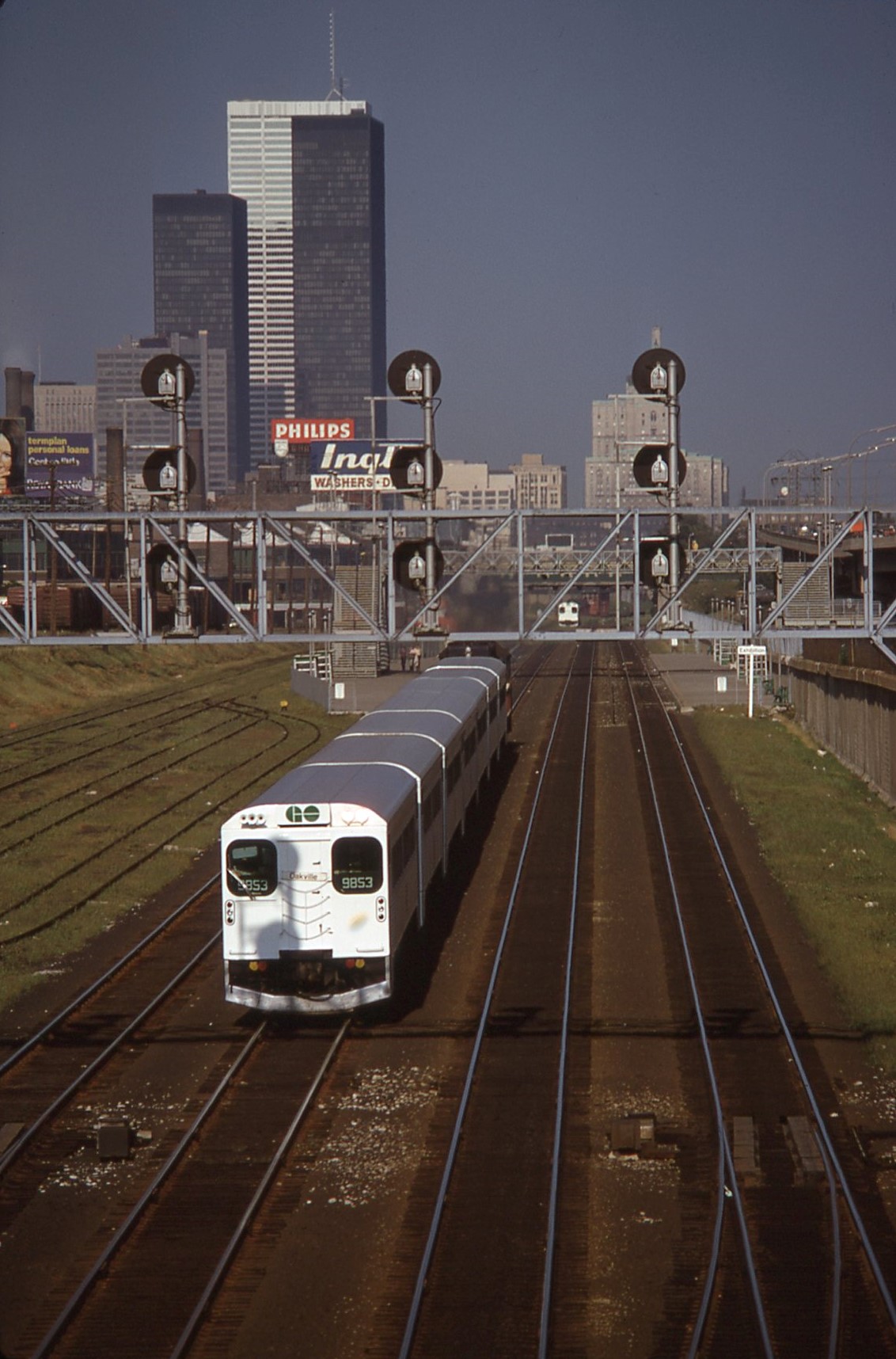
Looking east to GO Exhibition Station from Dufferin Street, August 1972
Verster’s focus is the GO Expansion program. Important though that is, GO is hobbled by the geography of Toronto’s historical, radial railway network. There is only one cross-city line within Toronto (CPR) and one crossing the southern part of York Region (CNR). Both of these are busy freight routes where insertion of passenger services would be challenging, assuming that the railways even agreed to such a scheme, and their locations do not coincide with major population and job centres.
The railway network was created primarily to serve freight, and the early industrial districts of the region lie along rail corridors. The node at Union served not just passenger traffic, but also as an interchange with the harbour. That was very much the case until trucks took over much of the shipping market and highways became the focus for development. GO Transit inherited railway corridors whose locations fit a century-old industrial pattern. Modal interchange shifted to rail and truck terminals in the suburbs, and railways shifted much more to a line-haul role with trucks handling local distribution.
GO’s first half-century was a comparatively easy one taking the low-hanging fruit of existing rail corridors, building massive parking facilities along these lines, and basking in the arrival of thousands of commuters. That model does not work any more because the web of travel demands is much more complex than the legacy railway network. Parking garages are expensive and they occupy valuable real estate at stations.
Parking lots are a quick and relatively cheap way to address the “last mile problem” of linking stations to their customers, and GO is one of the largest operators of parking facilities in North America. As of April 2019, GO transit had 85,055 parking spaces while the rail network carried 219,000 daily boardings (the equivalent of 109,500 round trips). That is almost four parking spaces for every five commuters. (I have ignored the GO bus network here because it is much less dependent on park-and-ride demand.)
That model simply does not scale up, nor does it provide a “network effect” because it is highly dependent on personal vehicles. The system is capacity-constrained by would-be riders’ ability to get to the trains.
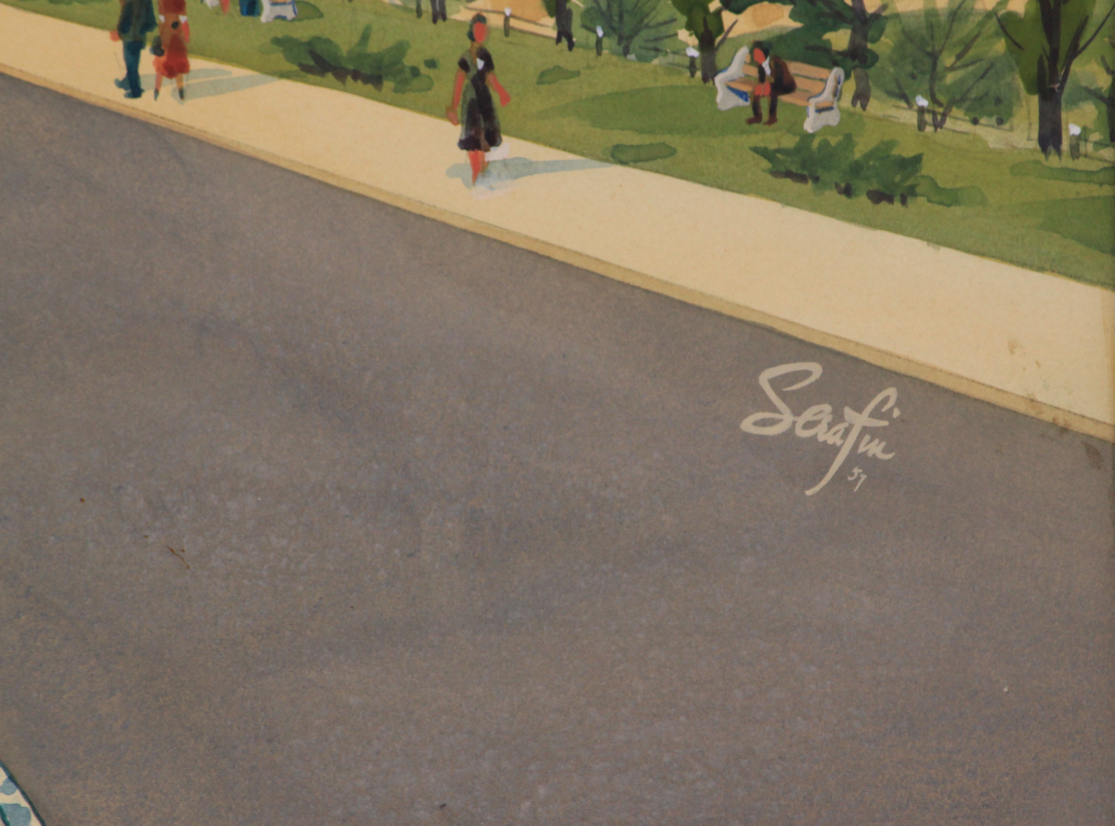
About 50 years ago, there was a housecleaning at TTC’s head office at 1900 Yonge Street. A room in what was then the Advertising Department stuffed with archival material was to be cleared out because they needed the space. A call went to the transit fans interested in preservating things that would otherwise be lost. This included a set of water colours by Sigmund Augustus Serafin who produced images of what subway station designs would look like long before the days of computer graphics.
These date mainly from 1957 when the Bloor-Danforth-University subway was still in the design stage. Few of the stations were built exactly as shown here. The quaint presence of the red “G” trains that ran on BD for only six months is a wonderful touch. Other vehicles include PCC streetcars and GM buses that predate the “New Look” era. Many buildings in the backgrounds no longer exist.
For decades these paintings lived in our family house, but in 2016 with what appeared to be a “friendlier” crew with Andy Byford in charge, I decided that it was time for them to go back to the TTC and the City Archives where they now reside. The TTC had thoughts of publishing them as posters, but that idea never bore fruit. The original mats around the paintings were in less than perfect condition when I received them, but the watercolours were and are almost like new.
Reproductions are on display at Bay Station, but they do not do justice to the originals. In anticipation of the TTC’s 100th birthday on September 1, 2021, here is a gallery of the paintings with photos I took while they were in my hands.
Click on any photo to open a gallery of larger versions.
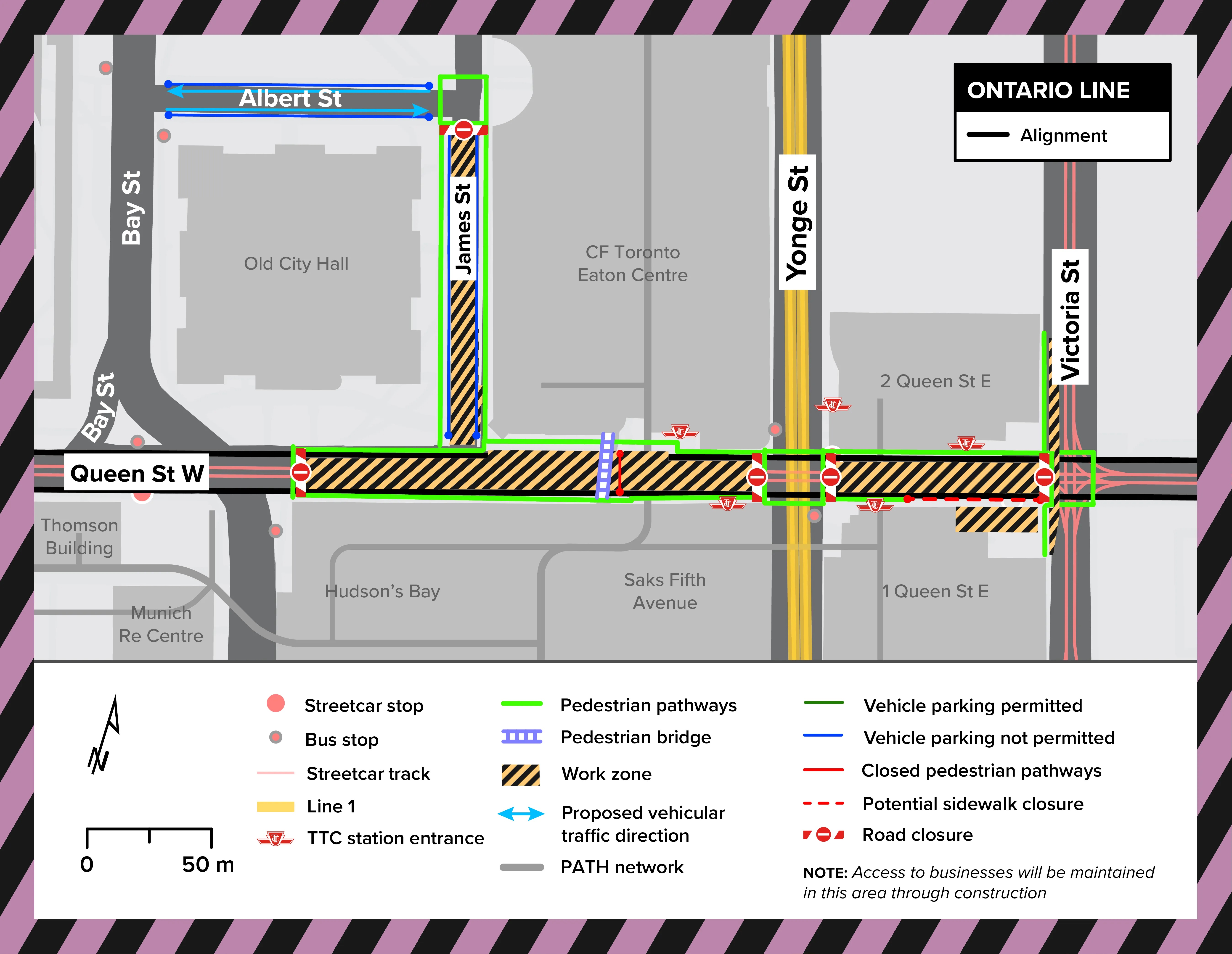
Construction of a new lower level station at Queen and Yonge will close roads in the area for an extended period according to a new blog article from Metrolinx. Between early 2023 for about four and a half years, Queen street will be completely closed from Victoria to James Street.
Source: Metrolinx
James Street will also be closed as well as a portion of the west side of Victoria Street.
Streetcars will divert both ways around the construction site via Church, the Richmond/Adelaide pair, and York. This will require York to become two-way at least south to Adelaide Street (it is two-way only from Queen to Richmond), and new track will have to be installed. Although the map above shows partial occupancy of Victoria Street, it is not clear whether the tracks, long out of use thanks to construction at St. Michael’s Hospital and at Massey Hall, will finally be reactivated.
Source: Metrolinx
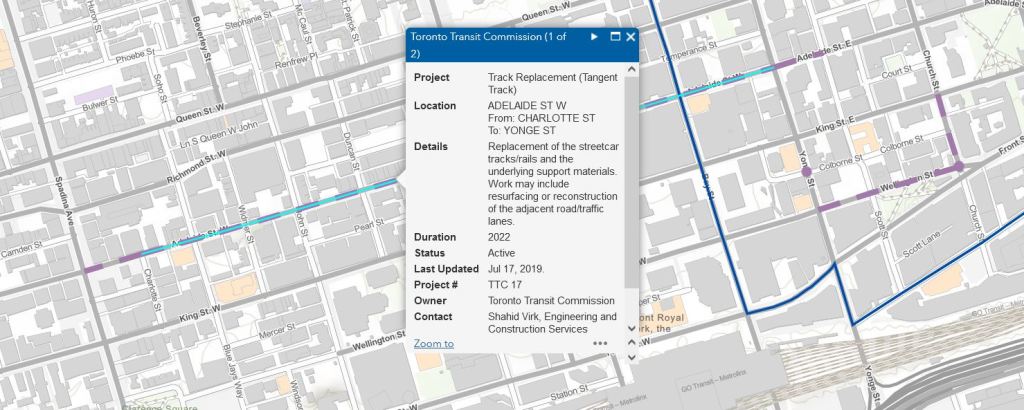
Reconstruction of Adelaide Street is already in the City’s plans for 2022. Originally, when I asked about the scope of work, the feedback I received from the TTC was that this would only involve track removal from Charlotte Street (east of Spadina) to Victoria. However, with these diversion plans it is clear that new track will be required at least to York Street.
An obvious question here is what plans Metrolinx has for Osgoode Station, and whether a Queen diversion west of York will be required. It is conceivable that the Adelaide trackage may yet live again further west. There will also be construction effects at Queen/Spadina and King/Bathurst. I have written to Metrolinx asking when details of these projects will be available so that the entire plan for downtown construction will be clear.
Source: City of Toronto, TOInview
A further issue is that there is a major reconstruction of King Street planned in 2023. This would have to be well out of the way before Queen Street could be closed. If there will be track on Adelaide to which a connection could be provided at York, a new east-to-north curve would be an obvious addition at King.
More generally, there should be a plan for the future use of downtown streetcar track to support the various diversions needed for construction and to restore some of the flexibility in streetcar operations that has been lost over the years as less-used bits of track fall victim to various construction projects. A list of potential locations includes:
Adelaide Street from Charlotte eastward, not just from York, including connecting curves at York.
An east-to-north curve at King and York.
Reactivation of track on Victoria between Queen and Dundas.
Addition of curves in the SE quadrant at Church and Carlton (reconstruction is planned there in 2022).
I have written to the TTC asking what their plans are.
Too often, chances to improve the network have been missed when track is rebuilt “as is”. This is an excellent chance to rectify past oversights.
A further issue in all of this will be the effect of redirected streetcar (and other) traffic on the cycling network downtown. I will seek info about this from the City of Toronto.
I will update this article when I receive additional information from Metrolinx and the TTC.
Metrolinx has an unerring ability, in the name of progress, to propose infrastructure that will not be friendly to its neighbours. Coupled with an organizational arrogance and the pressure to deliver on Ford’s transit dreams, this can produce unhappy relations with areas where they plan to build. It is convenient to portray those objecting to Metrolinx works as misinformed Nimbys, or to gaslight them by suggesting that nobody else in the known universe objects to their plans and to “progress”.
They are so confident that their copious output of publicity includes unintended double entendres such as:
Transit runs both ways. The conversation should too.
Once the progress train gets moving, there’s no stopping it.
The first is advice they could well take themselves, while the second implies that any “conversation” will slam into a brick wall of we-can-do-what-we-want enabled by provincial legislation.
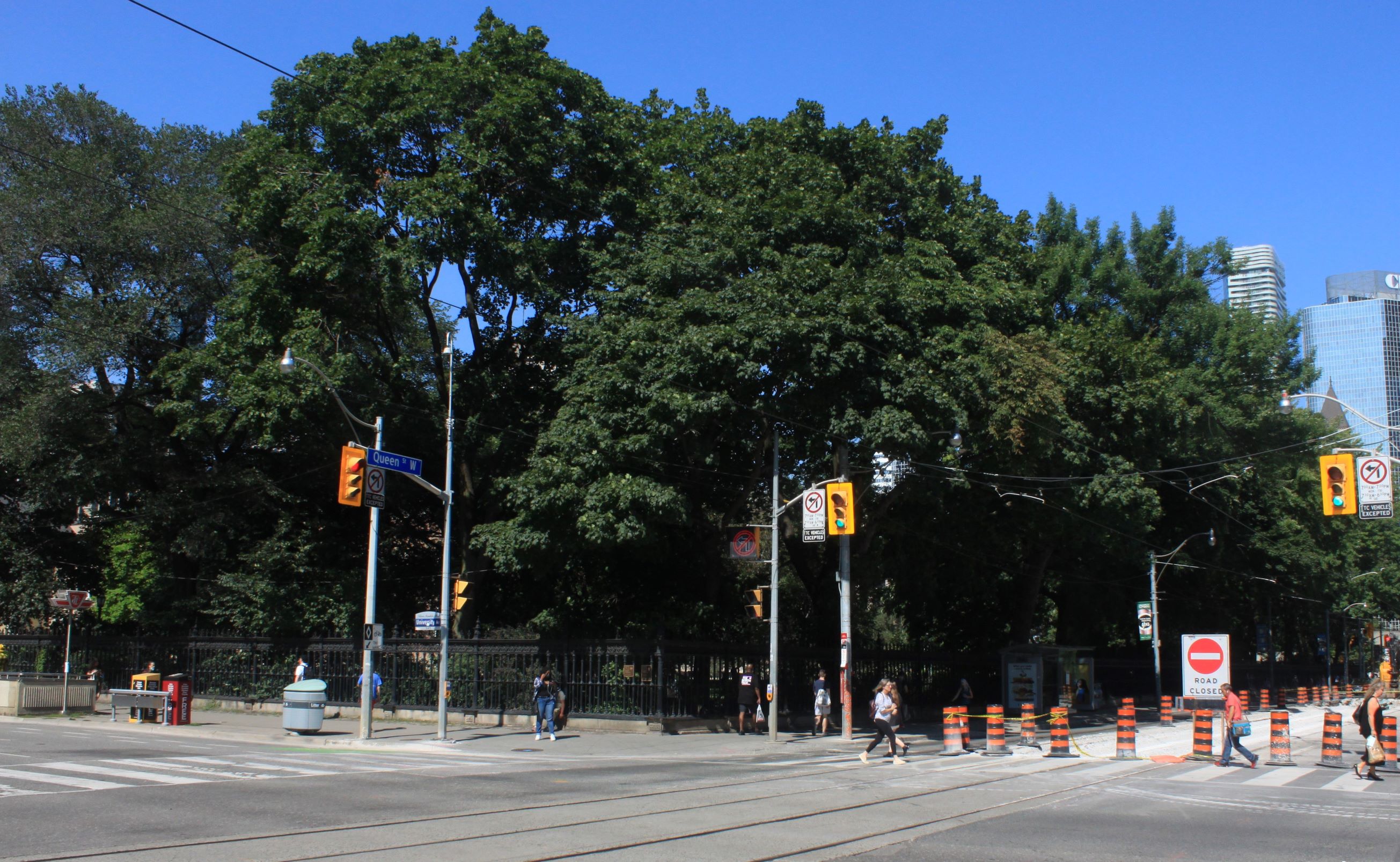
Neighbourhoods along the eastern side of the Ontario Line have received most of the publicity regarding pushback on Metrolinx plans, but one appalling proposal, in the heart of the city, has gone unnoticed: Osgoode Station.
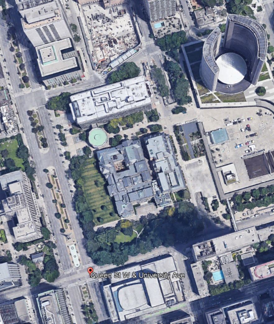
Queen & University, NE Corner, Aug 5/21, Photo by Steve Munro
The proposed Osgoode Station on the Ontario line will be an interchange point with the University Subway. To bring the combined station up to current fire code as required when any major change like this occurs, more entrance capacity is required. Metrolinx proposes to put a new entrance (sitting on top of an access shaft) right on that corner.
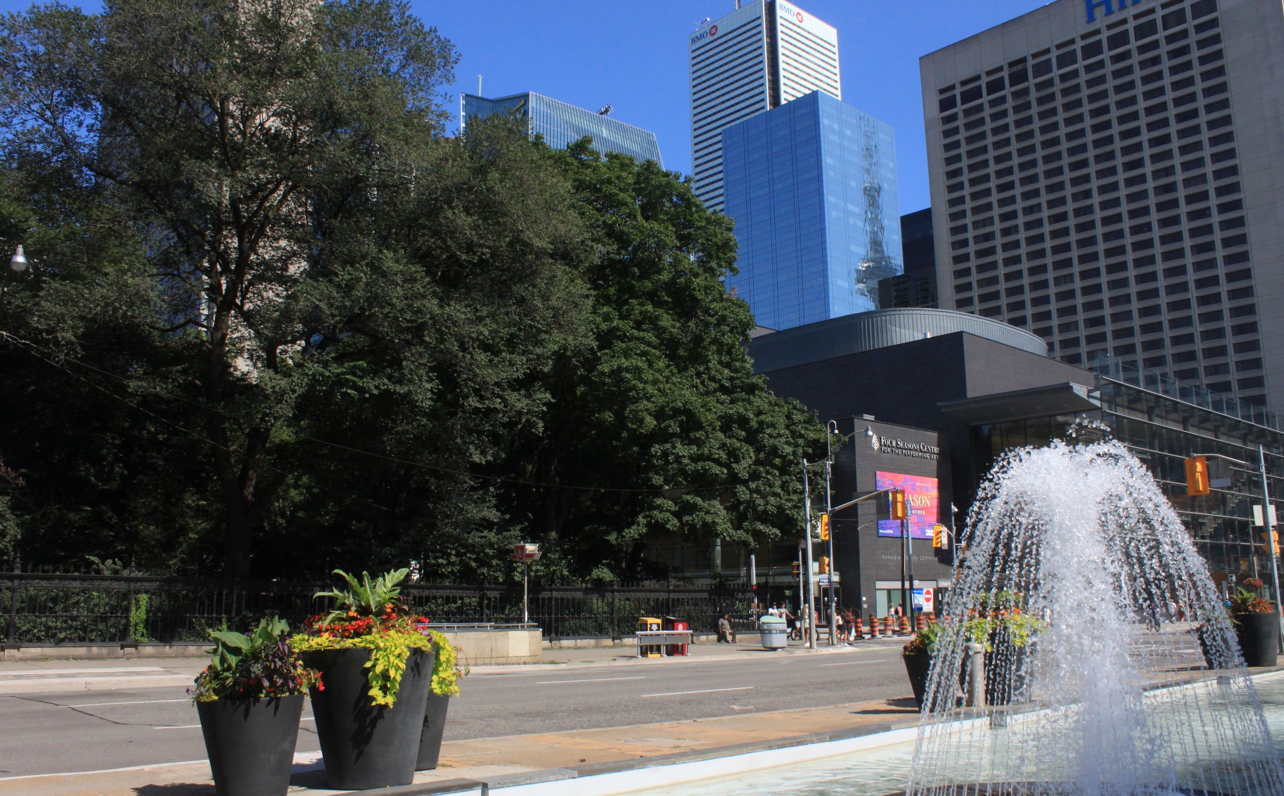
Here is another view looking south on University.
University Ave E Side Looking SE to Queen, Aug 5/21, Photo by Steve Munro
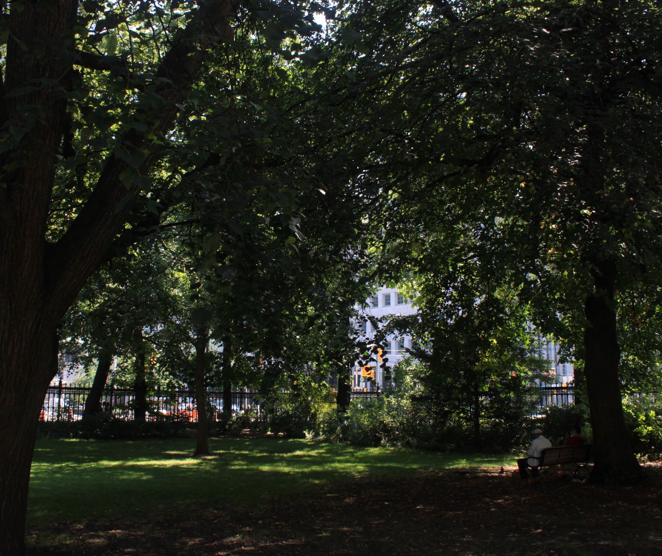
Here is a view from inside the park.
Looking SW Toward Queen & University, Aug 5/21, Photo by Steve Munro
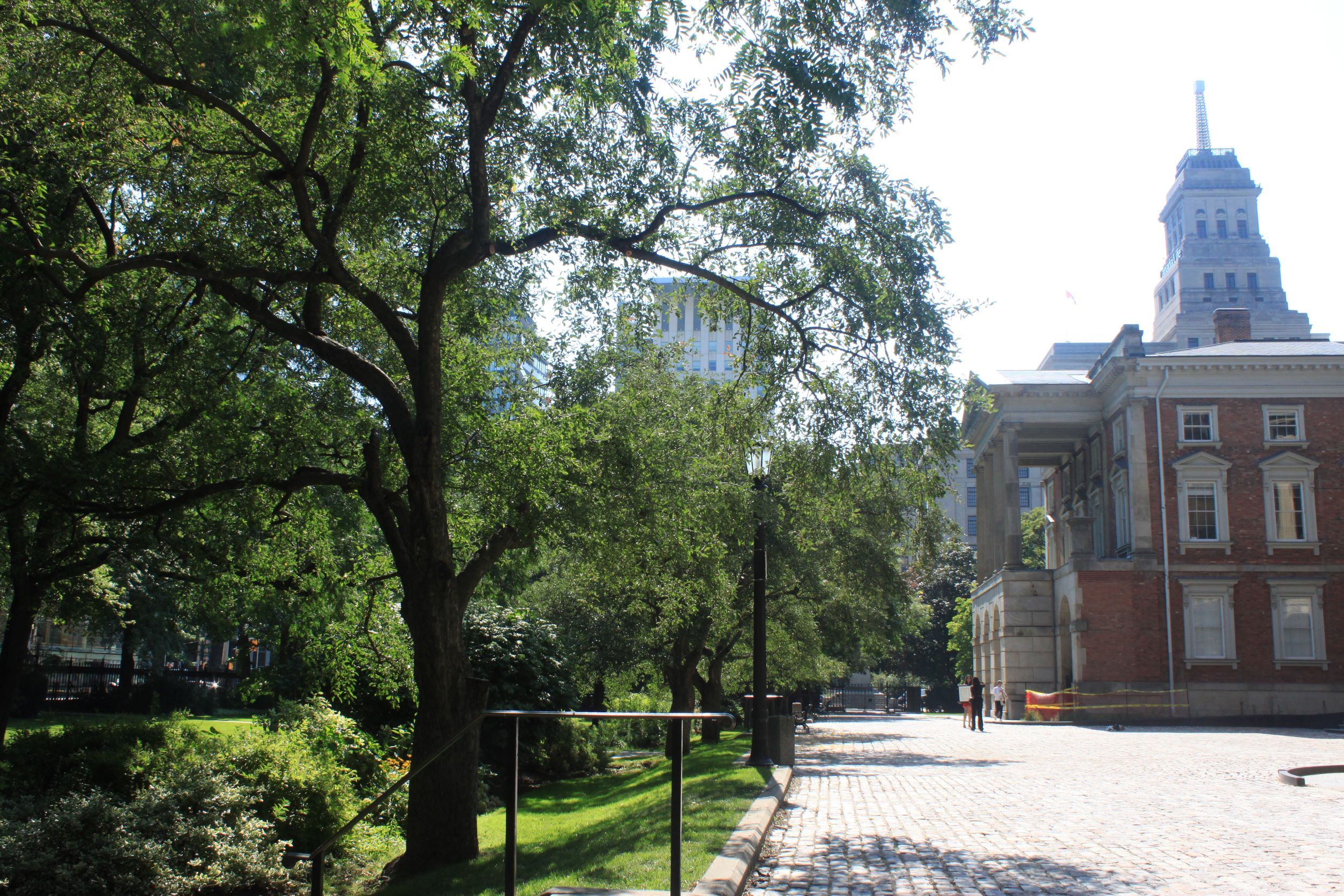
This is not the only park that Metrolinx has in its sights (the grove of trees at Moss Park Station west of Sherbourne will vanish), but this particular forest is part of an historic site going back to the City’s origins. It stands in front of Osgoode Hall dating from 1829.
Looking West Across Osgoode Hall Courtyard, Aug. 5/21, Photo by Steve Munro
Before the Ontario Line was proposed, Osgoode Station would have been the western terminus of the Relief Line and it would have shared the entrance facilities of the existing station. The stairways on the southwest corner of Queen & University would have been replaced by a new entrance through the former Bank of Canada building on that corner.
The secondary entrance, required to provide an alternate exit from the new Relief Line station, would have been at York Street.
Osgoode Station Street Level Plan from Relief Line Design Documents, 2018.
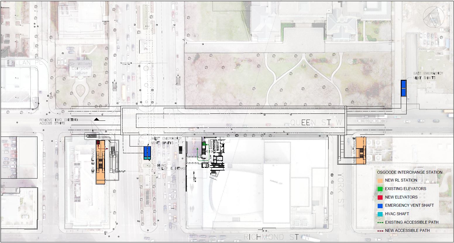
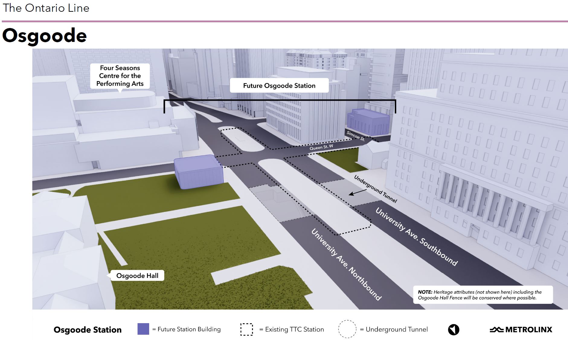
The Ontario Line’s Osgoode Station is sited further to the west. This is the high level view showing the two proposed new entrances to the station at University Avenue (NE) and Simcoe (SW).
The station area, as seen in the satellite view:
Source: Google Earth
Metrolinx shows their property requirements in the drawing below, but this does not include lands required as a “lay down area” for materials for the station project. Note also that their tunnel appears to run under Campbell House (northwest corner, south of the Canada Life Building) when it fact it is supposed to be directly under Queen Street. This is at least partly an error in perspective, but it misrepresents the tunnel’s location.
Source: Metrolinx
A further entrance will be required on University Avenue somewhere north of Queen to provide a second exit from the existing Osgoode Station which does not meet fire code (it has only one path from platform to street level).
A related consideration in the station design is a proposed reconfiguration of University Avenue so that what are now its northbound lanes would shift to the median, and the east side of the street would be an expanded sidewalk and park land. If this scheme proceeds, then both the new entrance and any lay down area needed for the station should be co-ordinated with the reconfiguration of the area around Osgoode Hall. Tearing out part of the park is a quick-and-dirty approach to station design that is totally out of place on this site.
I asked Metrolinx about their planned design.
One of the outstanding issues about Osgoode Station is why or if it is actually necessary to locate an entrance building on the Osgoode Hall lands.
The original Relief Line Station lay between York Street and the west side of University Avenue. It had two entrances: one was at York Street, SE corner, and the other was through a new joint entrance to both stations on the southwest corner through the old Bank of Canada building.
With the shift of the Ontario Line station box westward, the west entrance of the OL station will be through the old bank on the SW corner at Simcoe. The new east entrance is proposed for the Osgoode Hall lands. Why, by analogy to the original design, is this entrance not simply consolidated with the existing station entrance on the NE corner rather than taking a bite out of the historic lands of the Hall?
I know that there is a need for two exit paths under fire code but must they be completely separate from the existing structure? Why would this not have applied equally to the original Relief Line design?
Any significant change in the use of an existing station requires that it be brought to current code. The existing Osgoode Station only has one exit path. Does the additional load the OL interchange represents trigger a need for a second exit from that station too (ie something surfacing in the median of University Avenue from the north end of the station)? There has never been any discussion of this as part of the OL project. Is the OL providing two completely separate entrances to its station to avoid triggering the need for a second exit from the existing Osgoode Station?
Email to Metrolinx July 28, 2021
Metrolinx replied:
Thank you for your email. We also know that transit is sorely needed in Toronto and the broader region. Building a subway through the heart of the largest city in Canada in some of the areas of greatest density was never going to be easy. We know it will have impacts for some, but the necessity of the Ontario Line requires us to make these difficult decisions to build the transit network needed for this region.
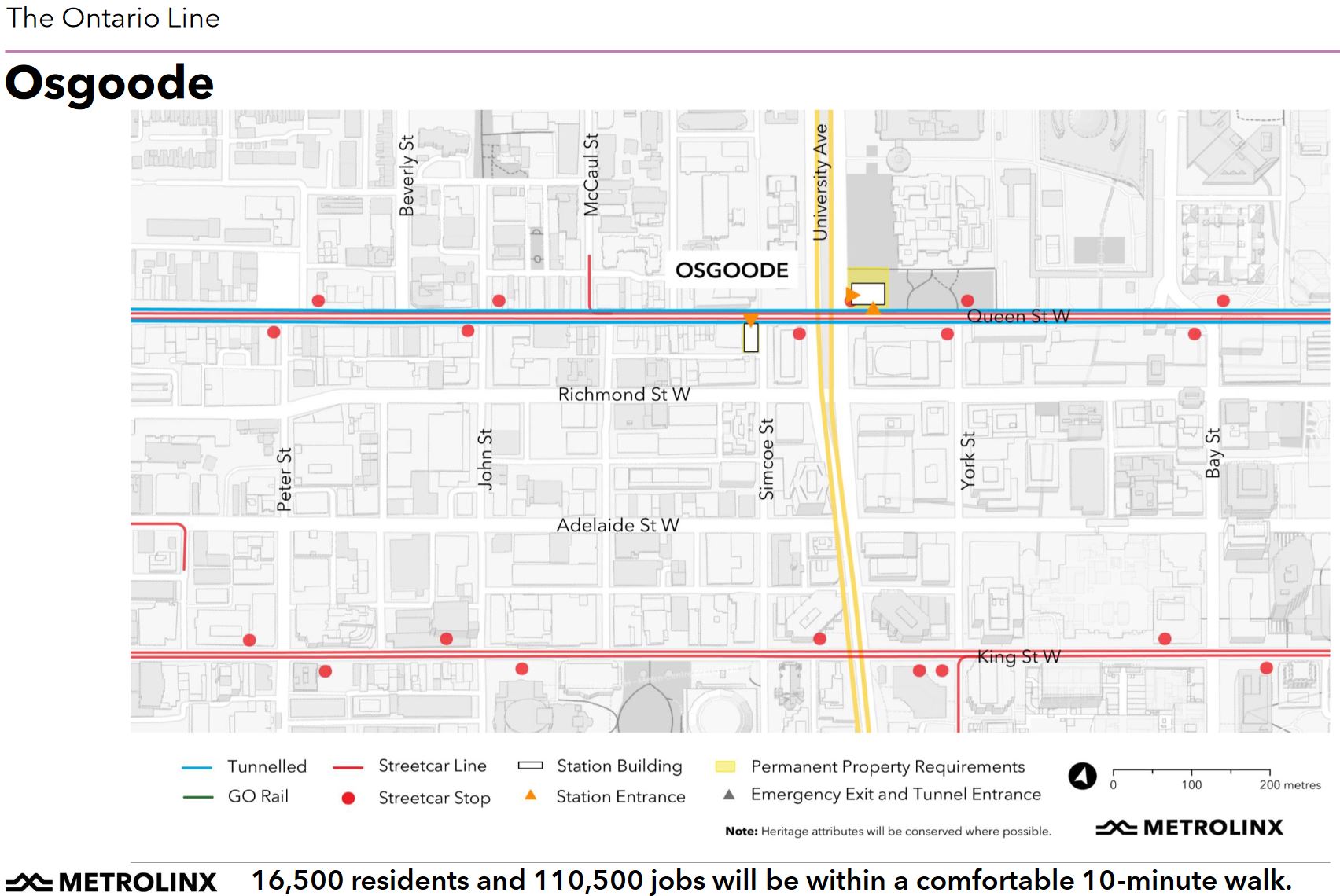
Osgoode Station is one of the four interchange stations the Ontario Line has with the TTC subway network, providing a direct connection to Line 1 Yonge-University. As you know, it will serve an estimated 12,000 riders arriving and departing Ontario Line trains during the AM peak hour alone in 2041, making it the third busiest station on Ontario Line.
The station will be located directly below the existing Line 1 station with a connection to the existing TTC concourse within the same ‘fare paid’ zone below ground. The existing Line 1 concourse level will also need to be expanded to meet fire code requirements as an interchange station. The major challenges involve constructing under, and connecting to, the existing station with minimal disruption to daily operations and minimizing any risk of damaging the structural integrity of the station itself. Within such a highly urbanized area, the work is further constrained by the limited availability of undeveloped land to construct a vertical shaft to access the deep below-grade construction site and for a suitably sized site to accommodate necessary laydown and staging activities on the surface.
In the case of Osgoode station, we know the passenger demand at this station necessitates the need for crowd management provisions and efficient surface network transfers. Two entrances, one at the west and one at the east end, of the new station are required to accommodate the anticipated passenger volumes and to meet safety and fire code requirements.
The TTC’s entrance for the existing Line 1 Osgoode Station does not provide sufficient capacity for the ridership expected when the Ontario Line is in operation. We also looked at various other location options for the Ontario Line Osgoode Station entrance buildings in this area. The proposed locations are the only ones where we can construct the station entrances and meet the necessary safety and code requirements.
We are working to minimize the footprint of Osgoode Station to the greatest extent possible. We will work with the Law Society of Ontario, the City of Toronto’s Heritage Preservation Services and the Ministry of Heritage, Sport, Tourism and Culture Industries to make sure we are not impacting more than we need to here.
Email from Caitlin Docherty, Community Relations & Issues Specialist – Ontario Line, August 9, 2021
Metrolinx is not known for “working with” affected communities preferring to bend any opposition to their predetermined plans. It will be interesting to see how they deal with this site and whether a better approach to Osgoode Station’s design and construction can be achieved that leaves the existing landscape intact.
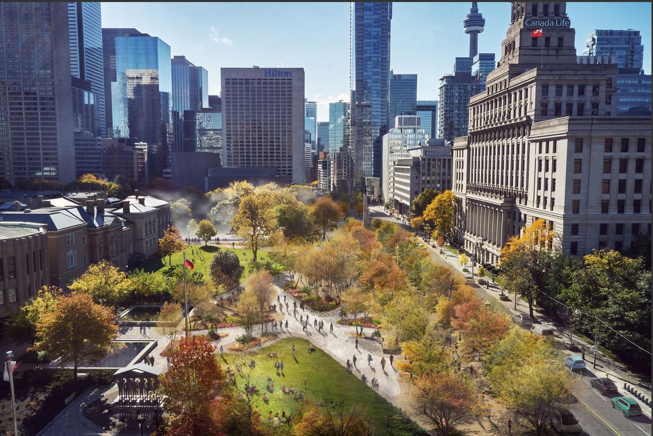
The University Avenue redesign project appears to languish at City Hall while schemes such as the now-defunct Rail Deck Park soak up the political attention. This would be a chance to transform University Avenue from a suburban style arterial born of an era when much of downtown’s streets and built form were treated as expendable. City Council and Mayor Tory should seize this chance to make a grand street in the heart of the City.
Several weeks ago, when Metrolinx began publishing its Neighbourhood Updates and Station Profiles, I asked for a consolidated set of ridership estimates. The material originally presented varied slightly from location to location, depending on each profile’s author. Most importantly, the numbers showed the utilization of each station, but not the projected loads on trains.
The stations might be a nice place to visit, but the real purpose of a transit line is to move people. For that, an important planning question is how many people actually want to ride in the peak period.
Metrolinx has now supplied this info (the have also updated some of their online information), and I present it here for readers’ interest.
The table below combines information from two Metrolinx sources:
The station-by-station projections sent in reply to my request, and
The projected numbers of transfer passengers, population and jobs taken from the station profiles.
To this data I have added a few extra columns to show the degree to which demand originating at each station is in the “inbound” direction heading toward downtown, and the proportion of demand at a station that walks in or out rather than transferring from another route. (Click on the image below for a larger version.)
A few things leap out of this table, notably the variation in usage at each station, and the large variation in whether traffic originates from or transfers to other transit routes, or is “local” to the neighbourhood.
Science Centre Station is particularly striking because 86 per cent of riders boarding or alighting there in the AM peak hour are projected to transfer to or from the Eglinton Crosstown line or from the local bus routes. Considering the scale of development projected for Don Mills and Eglinton, both commercial and residential, 14% for local walking access is a surprisingly low proportion.
Pape Station also has a low proportion of walk-in trade because activity there is dominated by transfers to and from Line 2 Bloor-Danforth.
Transfers to/from GO Transit are projected at 8,600 for East Harbour and 6,300 for Exhibition, and almost all of these are GO-to-Ontario Line given the highly directional nature of GO’s demand. These are the riders that Metrolinx hopes to divert from Union Station.
Metrolinx commonly cites the 14-15k total of GO-OL transfers for the two stations as if this were the benefit for each of them. The Exhibition Station Profile claims:
Giving customers another way to transfer between GO Transit’s regional rail services and the local subway system will take pressure off of Union Station, the country’s busiest transit hub. This new interchange will help reduce crowding at Union by about 14 per cent – or 14,000 fewer people – during rush hour.
Similar text is used for East Harbour Station. Moreover, this claim did not change after the much-vaunted “across the platform” transfer connections and their supposed convenience were dropped from the plans.
Where Are Riders Going?
Published Metrolinx data do not contain cross-tabs of origin-destination pairs and so we cannot see the details of where these riders are going, but one can get an idea of the popular locations by charting the boardings, alightings and accumulated loads on the Ontario Line for each direction of travel.
Westbound demand is the strongest in the AM peak hour accumulating to just over 20k on-train passengers in the peak direction during this hour. The overwhelming sources of riders in this projection are, in declining order:
Line 2 at Pape Station,
Riders boarding at East Harbour, primarily from GO Transit, and
Riders boarding at Science Centre, mainly as transfer traffic from Line 5.
The primary destinations are Queen, Osgoode and Exhibition Stations in that order.
Eastbound traffic will originate mainly at Exhibition Station. This demand is comprised partly of transfers from GO Transit, and partly of walk-in trade from Liberty Village. There is no local transit transfer component.
East Harbour is the principal destination along with the two downtown subway stations.
These charts show how important both the East Harbour development and the anticipated transfer of riders from GO onto the Ontario Line are for counterpeak demand. The inbound traffic is far more oriented to Queen and Osgoode Stations (showing the “relief” function of the corridor) than it is to East Harbour.
The TTC Board met on July 7 with an agenda that did not attract much debate. The two big items were the CEO’s Report which is usually a jumping off point for general questions about the state of the system, and a presentation on the Osgoode Station “near miss” incident.
There have been many Metrolinx consultations recently, and a few common threads appeared sitting through this many hours of their presentations and Q&A sessions. Some of the frustration with Metrolinx comes from the way they present material, and from what appear to be shifting positions on key issues.
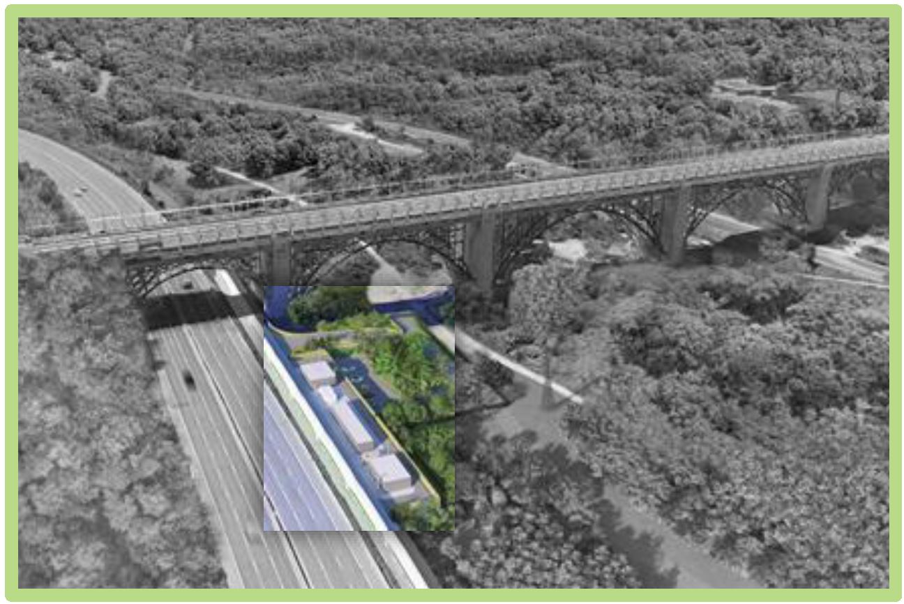
What Is The Don Valley Yard?
As a quick review, this “yard” is in fact a single storage track, the former CPR, now Metrolinx, Don Branch that once connected the CPR mainline at Leaside to Union Station. It is called a yard because the original proposal was for a three track yard south of the Prince Edward Viaduct.
Metrolinx proposes to convert the portion of this line for storage of three trains between the point where the line crosses to the east side of the Don River roughly at Rosedale Valley Road and the high level bridge near the Brick Works. The site is not accessible by public transit, although it is passed on one side by the DVP and on the other by the Don Valley Trail with many cyclists and pedestrians.
Here is the aerial view.
Metrolinx June 29, 2021 Presentation, p. 2
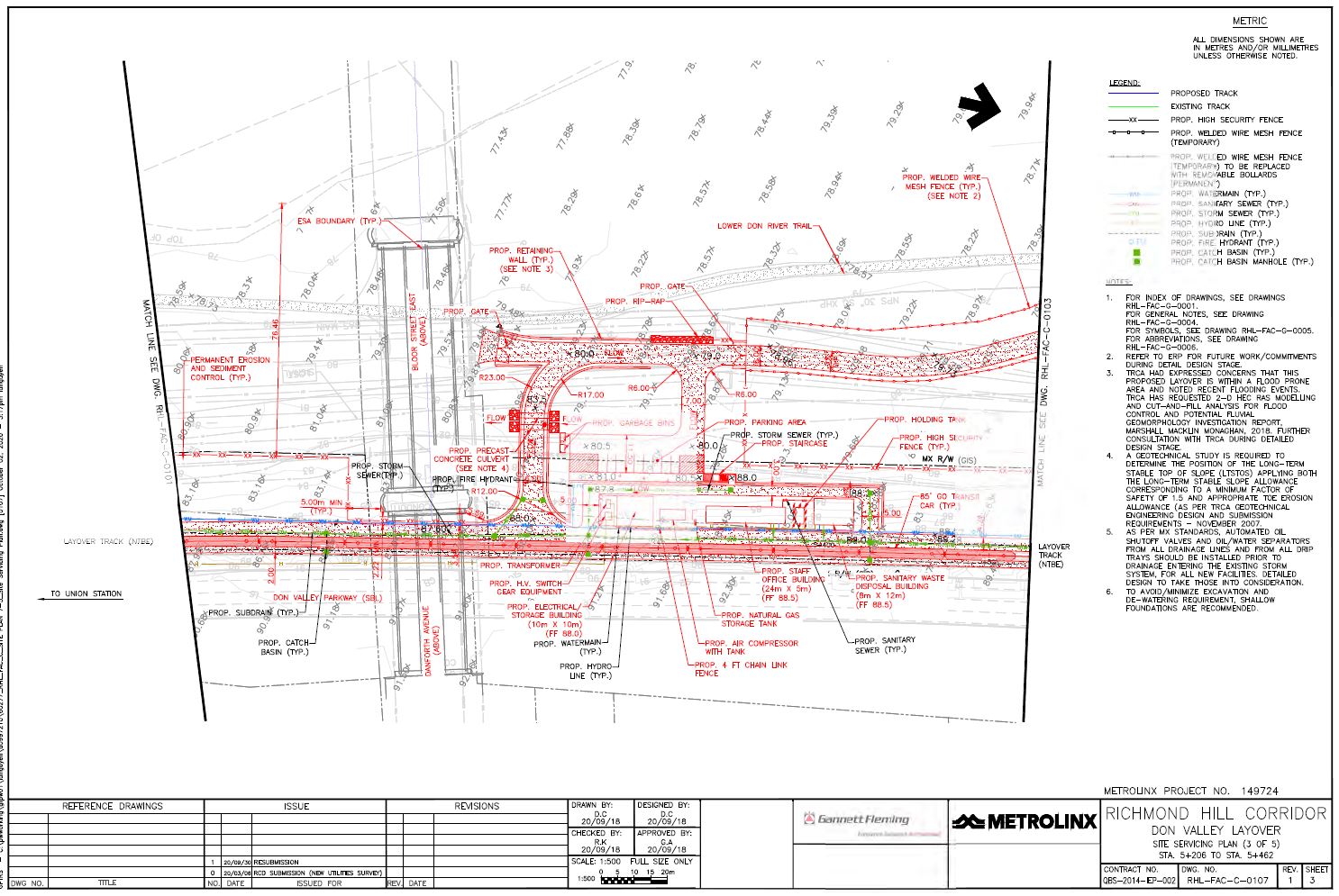
This will require the creation of a service road alongside the track for access to and from stored trains as well as supporting buildings and a small parking lot just north of the Prince Edward Viaduct. The site servicing plan, which includes buildings, roads, utilities and elevations (grey numbers on the diagonal giving the height above sea level in metres) is shown below. The buildings (from south to north) include an electrical building, and air compressor, a staff building and a sanitary waste building.
Click for a higher resolution image.
The valley floor rises gradually to about 80m at the western edge of the Metrolinx site, but the roadway linking the buildings is at about 88m. The parking area shown is on the valley floor, but there is a ramp for vehicles up to the level of the rail corridor. There is also a stairway from the parking up to the staff building. The land owned by Metrolinx is outlined in a broken black line “— – –”. Because of the change in elevation, a retaining wall (yellow in the aerial view) at least 8m high will be required except adjacent to the rail line.
The claimed purpose of the facility is to store three trains between the AM and PM peak periods and, possibly, to perform some light servicing on them. This does not align with the original proposal that clearly talked of a 7×24 operation with three shifts of staff. That might have been an error, a cut-and-paste job from one layover site to another, but the traffic study does speak of arrivals and departures corresponding to shift changes well outside of the midday period.
In any event, there is no provision in the plan for fuelling and Metrolinx claims that they intend to operate here only between the peak periods. We shall see.
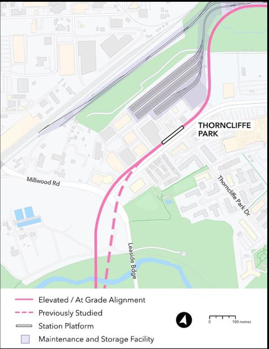
On June 30, Metrolinx held an online consultation for the North Segment of the Ontario Line between Gerrard and Science Centre Stations. Much of the discussion focused on plans for the Maintenance and Storage Facility at Thorncliffe Park.
The presentation deck and video of the session are available for those who want to review the whole thing.
The agenda for the meeting called for a half-hour presentation from Metrolinx, but they ran over by almost double. To their credit they kept the meeting going until they had run out of questions from the online audience.
Since the previous update, there has been a minor change in the alignment near Millwood and Overlea. The Don Valley crossing has been shifted slightly and the entrance to Thorncliffe Park moved to the north side of Overlea Boulevard. This is simpler to build because only Millwood must be crossed, and it moves the structure further away from residences on Leaside Park Drive.
The alignment east of there including the MSF layout is unchanged.
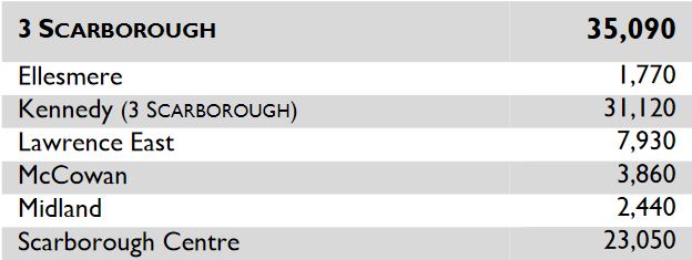
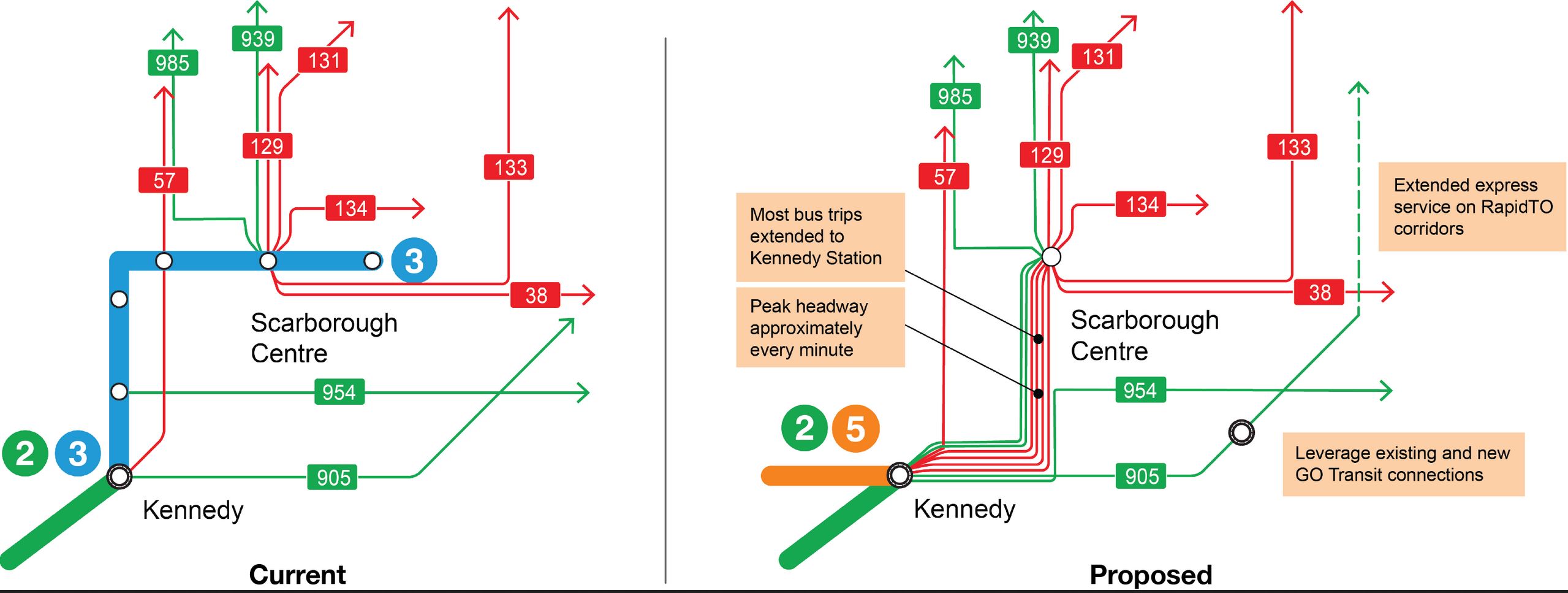
In about two years, July 2023, the Scarborough RT will shut down and be replaced by bus services until a Line 2 Scarborough Subway Extension opens in 2030. For seven years or more, riders will use buses to reach Kennedy terminal on Line 2, a change that will strain both the transit service and roads.
The TTC has a survey underway to July 16, 2021, to find out how riders think the bus service should operate, and to get a sense of how they use the bus network today.
The SRT operates primarily as a link between Scarborough Centre (aka STC) and Kennedy Stations with Lawrence East Station in a distant third place mainly because of transfer traffic from the 54/954 Lawrence East bus services. A replacement service does not have to duplicate the route of the SRT, but rather serve travel patterns between the major nodes.
The TTC plans to extend many routes now terminating at STC to Kennedy, but the challenge lies in the route that they will take. The combined service at peak will be about 1 minute, and that will strain road capacity. A saving grace is that buses will not stop often, and so they will not queue at curbside, but this bring an operational challenge for any mixture of local and express services. A reserved lane works best if buses do not have to pass each other by merging into other traffic.