This thread has been created to hold a string of comments that developed elsewhere about VIA’s less than first rate manner of operation as compared with other railways, even GO Transit.
Comments found elsewhere on this subject will be moved here.

This thread has been created to hold a string of comments that developed elsewhere about VIA’s less than first rate manner of operation as compared with other railways, even GO Transit.
Comments found elsewhere on this subject will be moved here.
Recent discussion about the Downtown Relief Line study and its Terms of Reference sent me back to the TTC’s Downtown Rapid Transit Expansion Study (DTRES) published last year for a look at the demand projections.
What I found there was rather troubling.
The TTC looked at three scenarios to model future shortfall in network capacity by 2031:
The demand model outputs appear in three separate tables within that study, but it is not until we consolidate the information that some anomalies really jump out.
There are four sets of numbers in this table with columns corresponding to the three model networks.
The capacity of the reference network is about 50% greater than the existing one. Note that for the northern GO services, ten-car trains are assumed although 20% could be added to the capacity with 12-car trains on the same presumed schedules. (The model also considered the east-west GO services and their effect in draining trips off of the BD subway that would otherwise contribute to demand south of Bloor Station.)
The modeled demand is also about 50% greater than the demand that the model assigns to the “existing” network configuration. This shows the modeled effect of increased transit service on network demand. However, this also begs the question of where those trips would be if the TTC and GO improvements did not take place. An obvious useful addition to the discussion would be the added road trips, or the trips simply not taken because there was no network capacity to handle them.
The big surprise is that there is almost no difference between the total demand with or without the Richmond Hill extension. Indeed, most changes are re-assignments of trips from GO lines and the University subway in the “reference” network to the Yonge subway in the “reference + YSE” network.
Route                    Without YSE     With YSE
University Subway           25,100        23,500
Yonge S of Bloor            35,800        39,400
Barrie GO                    7,500         7,400
Richmond Hill GO             2,500         2,200
Stouffville GO               8,600         8,000
Total                       79,500        80,500
Why would we spend billions of dollars building a subway to Richmond Hill to carry no more total riders on the network than we do without it?
There are two obvious responses to this question:
This is a rather strange situation considering that the holdup on building the Richmond Hill extension arose from the claim that it would overload the Yonge line. However, in the model, it does this primarily by attracting trips that would otherwise have been on GO or on the extended University subway.
(At this point, I have to wonder whether a similar methodology produced the inflated ridership projections for the Scarborough Subway, but that is another matter.)
The model shows very low ridership on the Richmond Hill line. Indeed, the greatest number of riders (2,900) is obtained with the “existing” network and the value falls even though GO service is improved in the “reference” and “reference + YSE” networks. This implies that the model prefers to assign trips to the “faster” Yonge subway especially when it goes all the way north to Richmond Hill.
On the BD line, although an increased capacity is included in the model (about 27%), ridership only goes up in the section east of Yonge. This implies either that demand from the west is static (difficult to believe) or that it is going somewhere else in the model. Where? Is growth assigned mainly to GO because it competes well with the subway for traffic in Mississauga while to the east Scarborough is poorly served by GO?
There is no question that Toronto needs more capacity into the core area, but the modeled numbers in the DTRES are suspect. If anything, they may understate the problem and the potential benefits of alternatives to stuffing more riders onto the Yonge subway.
The TTC has a long history of downplaying the need for anything beyond Yonge subway capacity expansion (more trains, new signals, bigger stations) to the detriment of long-term planning for better GO service and new TTC subway or LRT services. For many years, all we heard about from TTC was the need for a Richmond Hill subway. Any other project was cold-shouldered because it threatened that favoured scheme. Only when capacity problems could not be ignored did the TTC turn to the “DRL” as a possible solution.
Toronto has been ill-served by this blinkered planning, and coming studies on the future of the transit network (without regard to the paint scheme on the vehicles) must be based on a fair and accurate assessment of how new and improved services will contribute to moving passengers and limiting the growth of congestion in Toronto.
This thread has been created to hold comments about a GO shutdown that have been accumulating in the Eglinton Station thread.
All such comments will be moved here.
The Transit Investment Strategy Advisory Panel has ventured off its supposed path of looking at ways to fund transit growth in the GTHA to at least one proposal for a change to the Metrolinx Big Move plan. This showed up at recent open houses in a handout that is not yet available online.
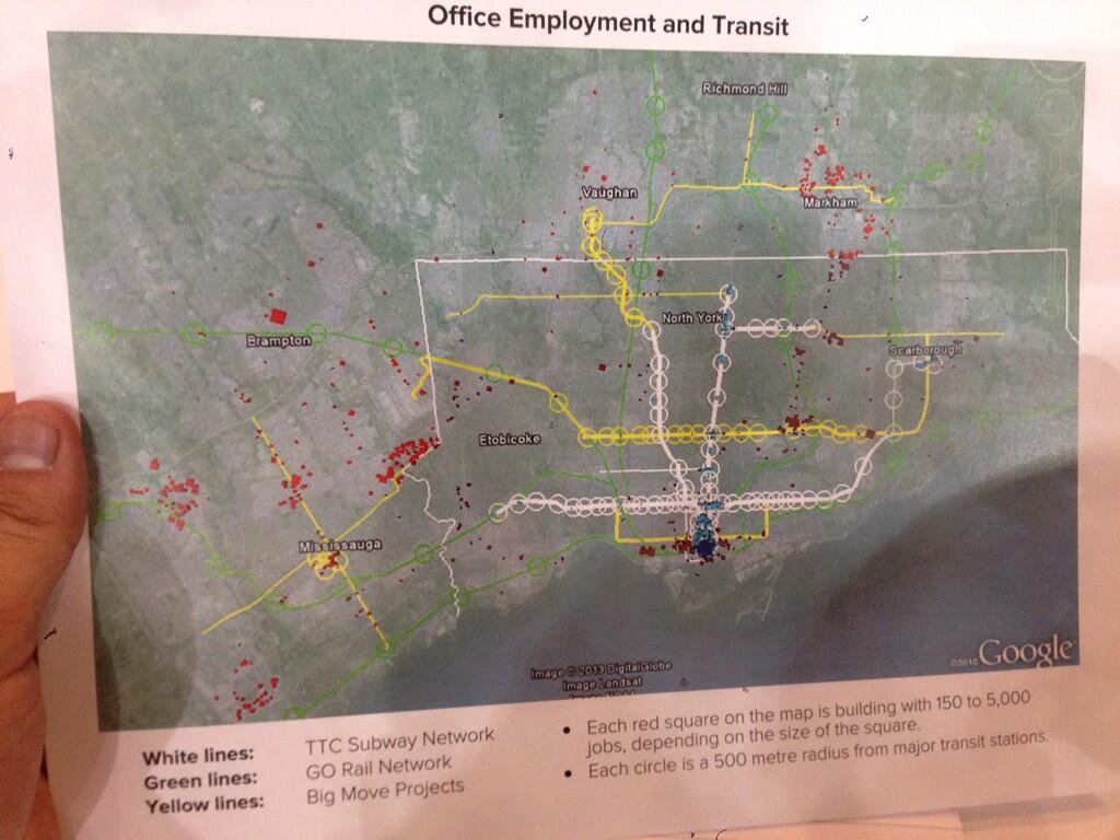
[The image above was posted on Twitter by Rishi L (@CdnEnginerd). Click for full size version.]
The purpose of this map is to show how office employment is not sited along existing or proposed rapid transit lines. With this as a jumping off point, the Panel suggests there is a need for a “Big U”, a much enhanced GO Transit route from Meadowvale, through Union Station and then north via the Uxbridge Subdivision (Stouffville line) to Markham.
A related factoid (one of those handy bits of information whose presence is supposed to silence critics) is that employment concentrations generate far more transit usage than residential ones. It is certainly true that it is much easier to serve a place like downtown Toronto with a transit network that acts like a big funnel, but this does not eliminate the need to serve the residential ends of those trips.
Toronto’s Bloor-Danforth subway and GO’s commuter lines, for example, spend much of their time running through comparatively low-density neighbourhoods, collecting passengers as walk-ins, park-and-rides, and transfers from the surface transit network. Every time a new transit route is proposed, we hear how it will only be viable if stations are surrounded by huge condo developments. This is utter nonsense because any transit route has a catchment area. The problem is to ensure that transit, sidewalks and bike lanes serve that area and deliver riders to a network that will take them where they want to go.
What is missing from the chart above is any indication of where the people who work in those centres actually live. Looking at the Meadowvale end of the line, how many people come from the area that would be served by the GO corridor and a feeder network to it? There is a lot of territory north, west and south of Meadowvale for which a rapid transit line to the east will do absolutely nothing. Similarly, many who work in Markham live west, north and east of the employment centres. Indeed, most of the red dots on that map are well west of the rail corridor.
Much as I sympathize with the Panel’s desire to get people talking about how parts of any network proposal might actually serve the region, I fear that we are seeing a classic example of someone who got out their crayons and drew a map. The job will quickly change from discussing the philosophy of transit planning (and, don’t forget, funding) to defending the specifics of a proposal.
That is precisely why I have been so restrained about getting out my own crayons except in special circumstances. The recent Don Mills Subway discussion needed a line on a map to illustrate how the “downtown” focus needed to change. Well over half of the debate this triggered became a matter of dueling proposals between “my” line and “your” line that added little to the real issue — the need to see what such a line could connect and serve beyond simply diverting trips away from Bloor-Yonge Station.
People would even argue that there wasn’t “enough” development in some locations to justify such a route ignoring what is there today, what is in the pipeline for tomorrow and what could occur with planning and political encouragement. Meanwhile, we build a subway to land that was recently the middle of nowhere, and propose one through miles of low density residential development as a vote-buyer claiming that only with a subway will Scarborough reap the development it “deserves”.
There is one big problem with the “Big U” — it diverts attention from the “little u” otherwise known as the “Downtown Relief Line”. It doesn’t help one bit that the version of the “little u” shown on the map is the Pape-Queen-Roncesvalles alignment, one that is guaranteed to be very expensive and fails to recognize shifting development patterns (ironically, one of the goals of the “Big U”). It ignores the southerly shift of population and jobs, avoids the available Weston rail corridor where we are spending a fortune to intensify transit infrastructure for a Toonerville Trolley to the airport, and it stops at the Bloor-Danforth subway missing the opportunity to reach further north to be more than a “downtown” line.
“Alternatives analysis” is a fine art in many projects, but the real art for many agencies is to ensure that what you always wanted to build is the “preferred” choice. This is often guaranteed by setting up straw man comparisons so that the one you want shines out as the best of breed. Such may be the situation with the DRL where, on darker days, I suspect that the whole idea is to paint as grim a picture as possible so that it will never be built. Remember that the TTC for decades claimed we didn’t need a DRL, that they could stuff everyone into an upgraded Yonge-University line. Expanding YUS capacity on a heroic scale was their “preferred alternative”.
With the Big and little U’s, we risk being trapped into specifics of route designs that looked good on a napkin in a bar, but which need much more thorough discussion as to purpose and specifics. They are good as starting points for discussion, but are most definitely not the final answer in their respective fields. Moreover, they are not alternatives to each other, a point that is often lost as the political imperative says “build in the suburbs, not downtown”.
The Big Move and the Investment Strategy that supports it have one gaping hole. Very little attention is paid to the role of or funding for the feeder network to a regional system. Moreover, the plethora of lines on the map hides the fact that many of them will not have the most frequent service on the planet. Not all “rapid transit” lines are created equal. As a recent Metrolinx report noted, the growth in “rapid transit” recently has mainly been in “BRT Light” for which the infrastructure requirements are minimal along with the service levels. Crowing about progress in bringing transit to the millions ignores the question of how attractive that transit will be and how people will connect from the trunk routes, such as they may be, to their homes, work and other destinations.
This will be an important issue for network design on both the Big and little U’s. One would serve rail corridors and be totally dependent on local service to deliver riders from homes and to employment locations. The other would serve established and growing neighbourhoods and would enjoy an existing, well-developed set of local transit services as feeders. These are not trivial differences, but they show the problems that will arise if the study does not look beyond the edges of station platforms.
This is the real debate the Transit Panel should engage — does The Big Move really serve the market it claims to address? How useful will it be in attracting trips out of cars and onto transit? Can developers and owners of residential and employment properties expect a real improvement in travel to and from their developments, or will their value be strangled by poor access? Underlying all this is the basic question of whether we are spending all of those billions in the “right” place and what benefit each component of the proposed network will achieve. That speaks directly to the concept of spending wisely, not just for the sake of generating construction jobs and photo ops for the next generation of politicians.
Returning to the “little u”, there will be a motion before Council from Councillor Josh Matlow, seconded by Cllr. John Parker (also a member of the TTC Board), to accelerate work on the EA for a “Relief Subway Line”. Moreover, it asks that Council confirm such a route as “Toronto’s next subway expansion priority”. It will be intriguing to see how this motion fares amid the current circus at City Hall, the recent battle over the Scarborough Subway and a faction claiming that downtown “has enough subways” already.
If this proceeds, it will be vital that it not be hamstrung with narrow terms of reference that filter out options before they are even discussed. A major shortcoming of the new “Transit Project Assessment” protocol is that there is no consideration of alternatives because the decision that something is a “good project” is already assumed. Debating alternatives just gums up the works in what is supposed to be an expedited process, but actually winds up as an exercise in selling an already-determined choice. This is precisely the criticism many had of Transit City that compounded the process with less than stellar detailed planning and “sales”. (Moreover, once a project is approved, it can be amended beyond all recognition, even though the original design was the one that “justified” the project in the first place.)
There is no point in doing a study if the underlying desire at the political and staff level is to sell a “Big U” as a replacement for the “Relief” line, whatever we call it. The terms of reference must ensure that all options are reviewed, including cross-jurisdictional issues such as repurposing the Weston corridor’s UPX trackage for rapid transit. We must not prejudge the outcome by requiring one continuous line to serve both legs of the U/u, especially considering that in some variants both western legs run in the same corridor.
Will Toronto Council, Metrolinx and Queen’s Park embrace the need for a full study of these routes without prejudice toward any preconceived doodlings on maps?
Metrolinx has published a study of the proposed subway extension to Richmond Hill updating a Benefits Case Analysis done in 2009. The new report is dated May 2013, but it has only recently been publicly released.
Background information in the study gives an indication of the demand challenges facing the transit network in coming decades. The study itself shows many of the shortcomings of Metrolinx analyses in the selective use of information and limited scope of alternatives comparison.
The study looks at four options for the Richmond Hill line:
Notable by its absence is an option of both a full subway line to Richmond Hill and improved GO service or any analysis of how demand would divide between the two routes.
The study notes that the Metrolinx Board, in response to earlier analyses, requested additional information:
- Possible adjustments in project scope, timing or phasing;
- Consideration of the extent to which improved service levels on the parallel GO Richmond Hill rail corridor off-loads some of the demand on the Yonge Street subway; and
- The cost impacts of the various options on the subway yards strategy, Yonge-Bloor subway station improvements, and a future Downtown Relief Line to bypass the Yonge-Bloor congestion pinch point. [Par. 1.12, page 3]
The 2013 report does not address these requests because it does not include any option where both the subway and improved GO service operate to Richmond Hill. Although parallel studies (such as the TTC’s own subway yards needs analysis) do look at some aspects of the third point above, this information is not integrated into the analysis, nor is there any review of configurations that could avoid some of the cost of increased subway capacity. This should follow in the Metrolinx study now underway of the Relief Line and associated alternatives, but that sort of network-based review is years overdue.
A comment thread developed elsewhere on this site about “Transit Priority Signalling” and what, exactly, this means in Toronto, and more recently in York Region.
I will move the related comments to this post to keep them together.
Updated August 2, 2013 at 6:00am:
André Sorensen has written a commentary in today’s Star expanding on his proposed use of the rail corridor for express airport service and a quasi Downtown Relief line. I’m with him on a more intelligent use of the rail corridor, especially to the northwest of downtown, but not with the premise that this could replace the proposed subway from Don Mills & Eglinton to the core.
The Metrolinx Board met on June 27 with a full agenda.
There is a great deal of duplication between various reports, and I have consolidated information to keep like items together. Some reports are omitted entirely from this article either because the important info is included elsewhere, or because they simply rehash status updates with no real news. Metrolinx has a love for “good news” to the point that each manager stuffs their presentations with information that is already well known, or which parallels other presentations.
Among the more important items in these reports are the following:
Updated June 13, 2013:
Contrary to the originally announced plans, the 31 Greenwood bus will not divert to Donlands Station during reconstruction of the bus loop at its home station. Instead, the buses will loop via Greenwood, Strathmore, Linsmore and Danforth stopping outside of the station.
Major service changes for June 23, 2013 include:
The service budget for September 2013 will be about 3.4% higher than the budget for the corresponding period in 2012, and 1% higher than for March 2013.
Earlier this week, Tess Kalinowski reported in The Star that Halton Region, a fast-growing region west of Toronto, would simply stop approving new developments without more provincial support for transit and other services. Chair Gary Carr wants to see funding for transit – including two-way, all-day GO rail service – not to mention schools, roads and public health.
Halton’s population of half a million is planned to grow by 50% in the coming two decades as new residents pour into the Greater Toronto region, but the infrastructure to support them does not exist. This problem is shared by other municipalities either because they face growth of their own, or because they lie between newer neighbourhoods and downtown and absorb increases in travel through older parts of the GTHA.
Metrolinx had originally slated all-day service for Halton on the Kitchener and Milton GO lines in the first 15 years of its 25-year Big Move transportation plan. But the plan’s updated version pushes the GO expansion to the list of projects in a 16- to 25-year window.
Besides more GO trains to Milton and Georgetown, Carr said the region wants Metrolinx to reinstate plans for another GO station on Trafalgar Rd. and it wants the Lakeshore West GO line electrified so it can deliver 15-minute express service.
Municipalities in the 905 now have (or are planned for) populations and the transportation demands they will create that exceed the capacity of road-oriented development. Even if transit in the 905 (and commuting capacity for 905-to-416 travel) were much better, the land use patterns work against effective transit service. This is not just a question of dispersed work and home locations, but of neighbourhood designs generally where stops to run errands as part of larger trips demand the use of a car. These problems will not be wished away with better bus routes or all-day GO service.
Halton, like many regions, is reacting to proposed new region-wide “revenue tools” with the question “what’s in it for us”, but this is a natural result of the “Big Gap” between the original promise of Metrolinx (and of provincial plans for managing GTHA growth) and what is actually happening on the ground.
Various plans exist for the expansion of GO Transit service, and these have changed from time to time leaving some confusion about what, exactly, will be provided and when service expansions will occur.
