
This article is a follow-up to my review of travel times and speeds on the 512 St. Clair route starting with the completion of the reserved lanes in 2010 and tracking forward to January 2020 just before the onset of the pandemic.
See: The Gradual Slowing of 512 St. Clair
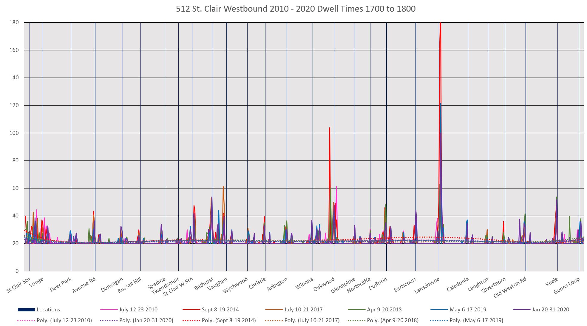
The charts in this article are based on the same six two-week periods used for the travel time analysis.
One issue on not just St. Clair, but on all of the TTC streetcar routes with reserved lanes, farside stops and supposed transit priority signalling is that riders and operators find that “double stopping” is a common event at traffic signals: once on the nearside to await a green, and again on the farside to service the stop. This is something of a mockery of the word “priority” suggesting either that it is not working very well, or that it is not working at all.
This is an important consideration in light of pending TSP proposals in Toronto:
- Both the Eglinton Crosstown and Finch West LRT lines will have “priority”, but it will work similarly to TSP installed on other routes. This does not bode well for speedy travel.
- There is a proposal to change the TSP algorithm (to the extent that it is active at all) so that only streetcars that are “late” to their scheduled times would get any priority treatment. This is counterproductive in a city where schedules are padded, and falling “late” is difficult to achieve. It is a recipe for no priority at all. (Moreover streetcars on diversion and extra service do not have a reference schedule at all, and it is unclear how they would be treated.)
The charts in this article illustrate where along the St. Clair route streetcars actually spend their time.
A few notes about reading these charts:
- The locations on the route are set out left-to-right for east-to-west. Yes, I know that this is the opposite of normal mapping practice where “east” is on the right. Eastbound travel is right-to-left in this chart. (This is a side effect of the way my analytic system “maps” routes with the zero point being at the south or east end of a route.)
- The vertical lines correspond to stop locations. Of particular note are cases where there is a spike on either side of the vertical indicating that cars stop both before and after crossing. Indeed, the “before” spike is sometimes higher than “after” indicating that more time was spent waiting for a green signal than serving the farside stop.
- The minimum value shown is “20” corresponding to the polling interval of the TTC’s now-retired “CIS” tracking system on which most of these data are based. Data from the new Vision system is more granular, but to fit with the CIS data, all times are rounded to the nearest 20 seconds.
- The methodology “counts” a car as being at a location for every 20 second interval through the day. Cars just passing by count for “1” and show up as the baseline of 20. Cars that are stopped count for however many 20 second “ticks” of the clock they are there.
- The horizontal granularity is 10 metres based on GPS data. This is small enough to resolve the east and west side of an intersection.
Here is the eastbound service in the AM peak hour.

Here is the corresponding chart for westbound travel. A few notes about this:
- The “before” side for each stop is now on the left side of the verticals (the east side).
- The spikes east of Dunvegan in 2018 (green) were caused by a delay that held service and created a backlog of vehicles.
- The spike westbound at Lansdowne is caused by cars that short-turned into Earlscourt Loop. Their time in the loop is counted as “westbound”.
- The spike in 2020 (purple) east of Gunns Loop suggest that streetcars were queued outside of the loop because it was already occupied.

Here are charts for midday:


And for the PM peak hour.

Finally, for those who want all of the details, here are the full chart sets on an hourly basis from 6 am to 11 pm.
A distressing part of looking at data over a decade is that the double stop problem has been with us more or less since the beginning, and it undermines the credibility of “LRT”.
Looking at these charts, I realize that a further refinement is possible: count the number of cars and the length of their nearside and farside stops relative to those that do not stop at all. A project for another day.

The next time someone touts unaccountable bureaucrats as a panacea to transit planning and operations… They may turn out to be career pencil pushers who, at best can’t get out of their own box, or worst are more interested in maintaining their own fiefdoms.
LikeLike
I use to be around Gunns Loop around Noon and frequently saw eastbound St.Clair car stopped at the far side stop island waiting for a car ahead to get to and leave stop at Keele which is one short block east. Car moved out of loop to allow arriving car to get into loop since it only holds 2 cars. Even at that a FIFTH car would sometimes to sitting stopped on St.Clair not turning right onto Gunns and dinging his bell. BTW NOT safe to let passengers off account no westbound island on St.Clair. All this while riders were waiting for ONE Runnymede route bus!
When a TTC Inspector was on duty for many months he kept things in good order for the most part by making sure a car did not leave ahead of time etc.
LikeLike
Signal priority based on the gap between vehicles would make a lot more sense then using the schedule for routes with frequent service, and be easier to implement.
LikeLike
Anecdotal of course but I can often miss a EB 512 streetcar at Glenholme that I can see sitting the W side of Dufferin waiting for the light, because the St Clair W traffic lights are prioritized only for cars. The light cycles around E/W and doesn’t change for N/S traffic. So we have an option to stand like fools or run across traffic for the streetcar which is 2 stops away. And we still miss it. TTC should see how Amsterdam prioritizes street lights. It isn’t for cars!
Steve: Yes. There are cases where the traffic signals work against pedestrians who are, after all, the streetcar’s customers. But there are some outrageous examples on BRT corridors in the 905 where riders have to be really dedicated to get to their transit service. Moving vehicles and moving passengers are two very different design challenges.
LikeLike
I am not sure what the problem is with Glenholme. If, after pressing the “I want to cross” button, the pedestrian signal for St Clair counts down and then resets, or cars in the U turn lane get to turn but no pedestrian crossing N-S, then 311 should be notified.
The “no signal for you [lousy pedestrian] if you don’t press the button” is something that Transportation Services needs to be disabused of (good luck!) but the N-S pedestrian signal should change (eventually) to walk after the button is pressed.
Of course, even if the pedestrian signal works, you can still miss your connection depending on the layout. Transferring from a southbound Spadina car to a westbound Queen. S/B car stops for red light, then finally proceeds. You get off on the farside stop. Obviously you can’t leave the platform, because the light is green N-S (because the streetcar just came south through the intersection). So you wait until the light turns green for E-W, and make your way to the east side of Spadina. Then you wait for the N-S signal again. By the time you get it, your W/B Queen car has come and gone.
Farside safety-island stops mean that you can’t get to the stop, or to the curb, pretty much when the streetcar is there, because the pedestrian signal for the island is “Don’t Walk”.
LikeLike