
Toronto City Council recently approved two related projects that, in theory, will help to improve transit operations.
The most striking point about these reports is that almost all of the benefits are in the future, they are confined to only part of the network, and there is no discussion of other factors affecting service such as the underlying capacity and the chronic lack of management and headway discipline.
Nowhere in these reports is there any discussion of the quality and quantity of service the TTC operates today. No mention of irregular headways and missing-in-action line management. No mention of the considerable pool of surplus buses that sit in garages rather than providing service on the street.
Far too much attention is focused on the premise that fixing transit is only possible with some sort of road intervention, and that this magic this will solve all our problems. Alas, that is not true, but the plans provide two rather large fig leaves behind which Council can hide claiming to have “done something”.
It is as if red paint alone will cure chronic problems. Can adverts for a TTC Miracle Tonic be far behind?
If we want less crowded buses now we must have more buses and better spaced buses. This cannot occur without a combination of better attention by the TTC itself to managing what it already has and by Council to budget realities of funding better transit service. Red paint on twenty streets over ten years will be an incremental change over a long period on those streets. It will not make the transit network, as a whole, noticeably better.
For its part, the TTC must not look at priority simply as a mechanism to reduce costs, but also as a way to improve service. This must be accompanied by much better line management and an ethos that makes well-spaced and evenly loaded buses a centrepiece of improved service. This would bring benefits across the city without a long wait for the red paint brigade.
Surface Transit Network Plan
The Surface Transit Network Plan set out to reconcile corridors shown in TTC and City plans for improves priority, as well as new targets that were either missed in previous rounds. The top 20 candidates would be prioritized and scheduled on a preliminary basis. This sounds aggressive in a city like Toronto that is good with pro-transit talk but less inclined to substantial action.
The plan has a $62 million pricetag for its first five years. Although this will be included in future capital budgets, there is no guarantee that it will be funded beyond the level of preliminary studies and consultation, if even that.
Moreover, there will inevitably be pressure for the TTC to show “savings” that can offset the cost of implementation. This endangers the very purpose of the project – the provision of better transit – not just the same level of service running slightly faster. Nobody expects transit costs to go down when a new subway line opens, and both the capital and operating budget investments are seen as a tradeoff for greater mobility and a more attractive service.
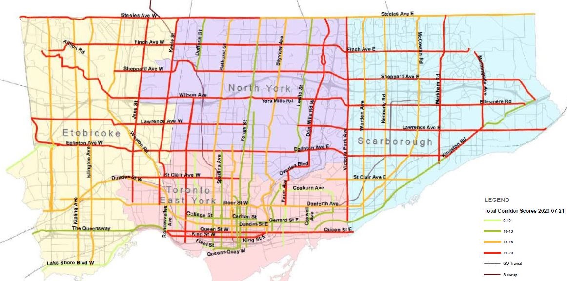
Many streets appear in the list of candidates, far more than 20, and the first task was to identify which of them were the most deserving of better transit facilities.
The map below shows the scored result with the top group in red followed by lower-ranked groups in yellow, dark green and light green.
The scoring included five components:
- Existing (pre-covid) ridership
- Equity
- Connectivity to Higher Order Transit (e.g. subway, LRT, BRT)
- Population and Employment Growth
- Ease of Implementation
Unfortunately for those who like to check the City’s work, the detailed scoring is not included in the report. The report contains a three-page description of the scoring methodology, but only a map summarizing its results [see Appendix 2, pp 17-20].
The King Street transit lanes are cited as the inspiration for this work, but there is a big difference between the core area of that street and most suburban roads in geometry, land use and, very importantly, all day level of transit and pedestrian activity.
“Ease of Implementation” is a particular concern because it will embrace all of the objections to lost parking, property access and congestion on whatever remains to motorists including nearby streets.
“Equity” refers to less well-off neighbourhoods that are more transit dependent, and these score higher for bus priority. There is an implicit assumption that transit dependent riders only use routes that pass through their home neighbourhoods.
An integral component of this plan is implementing transit priority measures that improve transit reliability, speed and reduce transit crowding in neighbourhoods with vulnerable populations, such as persons with low income, women, youth and racialized groups. An enhanced surface transit priority corridor can improve access to economic opportunities, City and other government services and spaces, food, health services and recreation.
Surface Transit Network Plan Update, p. 3
Congestion that might interfere with better transit does not necessarily lie within or originate from low-income residential areas. This can pit motorists who drive through such neighbourhoods against residents who want to see better transit. Moreover, not everyone who is poor is exclusively a transit user if only because some trips are almost impossible to make via that mode. The need for better transit serving such trips is completely outside of this study’s scope.
Most of the Top 20 come from the highest-scored tier although a few of those were omitted for obvious reasons: St. Clair already has a transit right-of-way, and Eglinton West will in time acquire an extension of the Crosstown Line 5. Bus routes into downtown are not part of this plan because there is a separate “Midtown Express Bus Study” covering this topic.

Although the Eglinton-Kingston-Morningside “RapidTO” lanes went into operation in record time, this was possible because much of the corridor is wide enough to take a lane in each direction, and on Eglinton there were already peak period bus lanes. It is also a corridor with few street-facing properties where access and on-street parking would be an issue.
The TTC came under much-deserved fire for the concurrent cutback in stops along the Eglinton corridor. As things turn out, stop removals are responsible for a good deal of the travel time saving. The TTC has wanted to reduce the number of stops on its routes for years, but after cuts on a few streetcar lines, never quite got around to the bus network and the political battles this might entail.
The report describes “transit stop consolidation” as a “feature” that complements transit priority measures. That is hogwash. If the TTC wanted to reduce the number of stops to speed up service, they could do that on any route today. Their usual argument is not transit priority, but safety through the shift of stops away from locations that generate mid-block pedestrian crossing activity. By bundling the stop changes with the BRT rollout, the TTC hoped to kill two birds with one stone. This did not go well.
Residents at affected stops raised serious questions about accessibility with the new wider spacing, especially during the winter when snow clearing on sidewalks is less than ideal. A more serious problem, however, is the lack of consultation because, in this socially distanced era, most of that was done online, a technique not necessarily available or accessible to many residents.
There has been enough pushback that some of the stop removals are on hold pending study of their usage patterns. One might reasonably ask why this information was not already available as part of the implementation study. An important distinction here is that all-day averages, a favourite TTC way to cite stats, could hide peak periods when some of these stops are quite busy. Stops in residential areas have different usage patterns than stops in commercial, educational or mixed-use areas.
In an hilarious “own goal”, the City held the on site media event to launch the project at Cedar Drive, one of the stops that was removed from service.
The implementation of future proposed BRT corridors will involve much more community consultation with two rounds – one to get initial concerns and feedback about each proposal, and one to review the detailed design. Those of us who went through the King Street project know that this can be a detailed, tedious business, but it pays off with better buy-in to the finished work.
Some of the target corridors have narrow stretches where a bus lane would represent half of the road’s capacity. There are issues with parking and access to houses and businesses on streets which are much more significant than on the Eglinton-Kingston-Morningside corridor. It is easy to dismiss critics as the equivalent of Nimbys in the cars-vs-transit debate, but a detailed review will shift the focus to real data about how roads operate and how they might be changed.
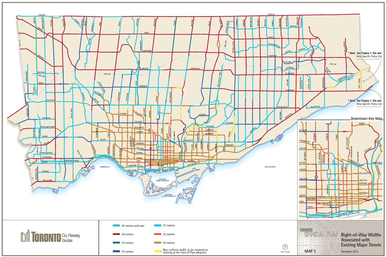
The map below, from the City’s Official Plan, shows the right-of-way widths for all major streets, although it does not show the access patterns. Some of these streets will be challenging as transit corridors especially where service does not operate frequently enough to dominate the road at all hours.
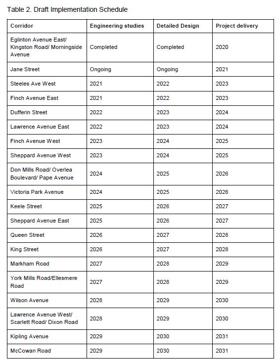
A three year rolling cycle of studies/consultation, design and implementation is proposed with three corridors entering the process each year. Jane Street is in progress already, and the City has already discovered that this is not a corridor where they can just throw down red paint and hold a media event.
At Council, some members raised legitimate concerns about other users of the road including motorists and businesses dependent on vehicle access. This takes us straight into discussions of whether the reserved lanes should be peak only (maybe with a lighter shade of red paint?).
However, some corridors see severe congestion in the off peak, especially on Saturdays when road use is building back to pre-covid levels as shopping traffic returns. Any review of a fully-reserved lane design must consider how the street operates at all hours, and not simply take peak period travel time and vehicle reductions as its goal.
Another design challenge will be support for the growing network of cycling lanes where the coarse arterial grid makes the creation of parallel transit, cycling and auto/truck corridors much more difficult.
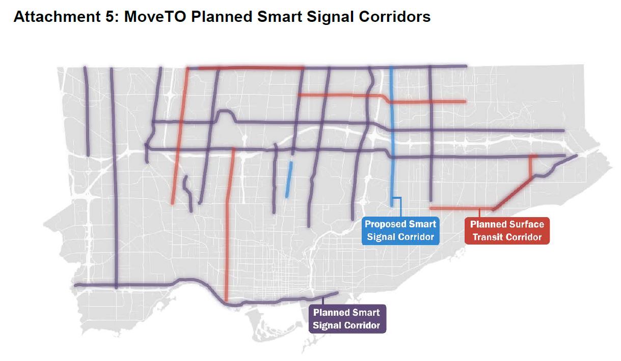
MoveTO 2021-25: Congestion Management Interim Action Plan & Smart Signals
Under the rubric of pandemic recovery, the City plans several changes to its traffic management schemes. Part of this addresses road congestion generally, while part is aimed at improved pedestrian and cycling safety and better transit operations.
In March of 2020, the City’s transportation system experienced the largest drop in transportation demand since traffic volumes have been recorded. As the COVID-19 pandemic was declared and the City as well as the Province moved into states of emergency, demand for travel on the City’s streets fell by more than half. Over the summer and through the various stages of the Provinces re-opening, traffic volumes have begun to increase again. These dramatic changes in demand disrupted decades-long patterns of growth and congestion, requiring a strategic review of operational capabilities to navigate the uncertainty and fluctuations in the number of vehicles on streets and the modal choices of travellers as demand recovers.
MoveTO 2021-25 Interim Action Plan p. 1
A sizeable chunk of this will be a $24 million plan to implement “smart” signals to improve intersection operations and adapt to actual traffic conditions.
This is part of a larger plan, MoveTO. Transit signal priority is a large part of this plan, but not in the 2021 budget.

Recent Traffic Patterns
The decline in traffic across the city has been substantial. In various previous articles, I have tracked the change in bus travel times on various routes including the almost total disappearance of the “peak” periods.
In the two months immediately after COVID-19 pandemic response measures were introduced, delays for motor vehicles were eliminated across the City’s road network. Improvements in city-wide travel times were measured at 37% and 44% during the a.m. and p.m. peak hours, respectively. While travel time delays are still significantly lower relative to those prior to the pandemic, they have gradually increased in recent months as services have reopened and car traffic has partially returned.
By the second week of April, daily car and pedestrian traffic in the downtown core dropped precipitously to 40% and 20% of pre-pandemic volumes, respectively. Cyclist traffic, on the other hand, increased to 130% of pre-pandemic volumes during this same period, in part due to the warming weather, but also as residents turned to cycling as a safe and physically distant travel alternative. Volumes for all three modes of travel have since more than doubled at the time of this report, but car and pedestrian traffic both continue to be well below pre-pandemic levels. All modes of travel have also experienced drastic shifts in time-of-day patterns, including a substantial reduction in the traditional morning peak.
MoveTO 2021-25 Interim Action Plan p. 6
The change in pedestrian patterns downtown was profound as entertainment venues closed and offices shifted to work-from-home.
Downtown pedestrian volumes decreased by an average of 80% by the second week of April, in large part due to the massive reduction of office employees working in the core. The largest percentage changes were observed at intersections within the Financial District (e.g. King and Bay), while those in close proximity to major residential areas (e.g. Richmond and Bathurst) were less affected. Volumes have since slowly recovered in recent months but continue to be significantly lower (an average decrease of 60% relative to pre-pandemic conditions) with large variances (decreases ranging from 40% to 80%) across intersections. It is expected that changes in pedestrian volumes elsewhere in the city are much less extreme given the unique concentration of dense service-based employment in the Financial District and surrounding areas. Reliable data on changes in pedestrian traffic outside of the downtown core is limited due the lack of multimodal monitoring infrastructure.
MoveTO 2021-25 Interim Action Plan p. 7
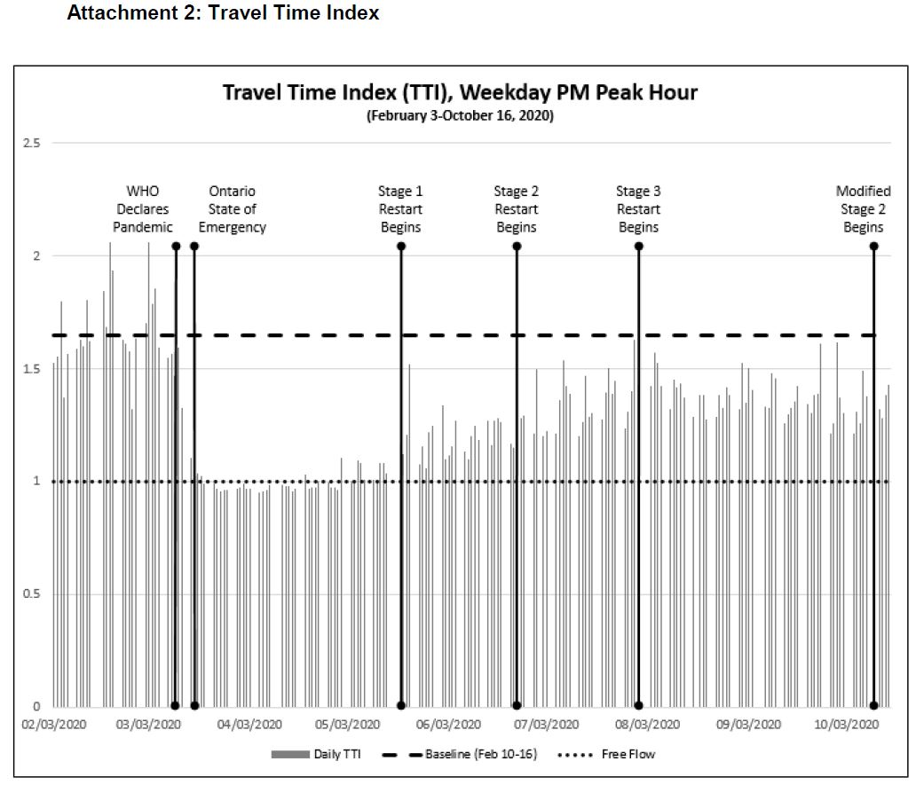
The City calculated a travel time index for its road network to monitor the change in traffic speeds. This is a network-wide value and the effects will vary from one part of the city to another just as they have done on the transit system. Although the index has not grown back to pre-pandemic values, the upward trend through late summer is clear. Recent changes to lockdown rules have blunted this growth, but it is reasonable to expect the trend to resume as the City re-opens.
Smart Signals
The Smart Signal plan envisages installation on many corridors, eventually, but the first two would be parallel to the expressway network where traffic patterns can change substantially depending on events on the expressways. Other streets would see Smart Signals, but not soon.
Based on experience on Sheppard East, the Smart Signals are expected to reduce travel times by 2.6% at peak, 2.5% on weekdays, and 1.0% on weekends. This is not a huge change, and moreover it is a one-time improvement. The real question here is whether Smart Signals will reduce or eliminate growth in travel times as we return to pre-pandemic conditions.
Intelligent Intersections
Intelligent Intersections are a variation on the theme in that they can recognize and provide for pedestrians and cyclists whose behaviour is very different from that of cars and trucks. The City plans to implement 100 locations over the next two years, but the report is silent on where.
By contrast to the Smart Signals program aimed at relief from expressway overflow, the Intelligent Intersections program collects detailed data on the types of activity on roads and paths. It will focus on three types of neighbourhood:
- Key gateways to/from the core area.
- Multimodal routes including cycling corridors.
- Corridors with high crash volumes where data about intersection behaviour can drive redesign.
This has already been operating downtown as part of the King Street project, and the City hopes to extend detailed data collection to other areas.
Advanced Transit Signal Priority
The Advanced Transit Signal Priority program aims to increase the sophistication of traffic signal responses to transit vehicles. The existing system was implemented on the streetcar network using pavement loop-based vehicle detection. This is vulnerable to failure or removal during road and track repairs, and is expensive to fine tune by relocating fixed detection points.
Transit Signal Priority (TSP) is an Intelligent Transportation Systems solution whereby a bus or streetcar is detected approaching an intersection and the traffic signal adjusts the signal timing to improve the operation of the buses or streetcars. TSP has been implemented at approximately 400 intersections in Toronto since 1990, with the City of Toronto and TTC collaborating over the years to develop highly advanced TSP green extension and other features to provide significant benefits to transit vehicles, while allowing impacts to other road users to be mitigated. Based on past surveys in Toronto the typical travel time saving for transit vehicles is up to 16 seconds round-trip per TSP-equipped intersection, which equates to a 10-minute round trip savings on a typical route with 40 TSP-equipped intersections. TSP is generally designed such that the priority would only be given if it was reasonably expected that the transit vehicle would require between 16 and 20 seconds of extension which could increase to a maximum of 30 seconds to account for variability in passenger service time and travel time.
MoveTO 2021-25 Interim Action Plan p. 13
It should be noted that a great deal of the time saving initially achieved on some routes, notably King, has been used to increase scheduled running and recovery times in recent years. One simply does not see transit schedule changes announced for faster service due to transit signal priority. It is important also to note that many of these changes are incremental especially when they target key intersections where transit vehicles are delayed.
The new system takes a different approach.
The new MoveTO Advanced Transit Signal Priority (ATSP) strategy proposes installation at additional intersections. This innovation will leverage the TTC’s new vehicle detection system known as computer-aided dispatch/automated vehicle location (CAD/AVL) to provide more service reliability and vehicle spacing. At the same time, ATSP will mitigate impacts on other traffic by providing priority to TTC vehicles on a conditional basis.
MoveTO 2021-25 Interim Action Plan p. 13
The reference to “a conditional basis” is that ATSP is intended to apply only to vehicles that are running late compared to scheduled times. This is a common approach used in cities that have less frequent transit routes where on-time performance is a key part of line management. This is most definitely not the case in Toronto.
Schedules on many routes are padded for worst case situations so that most trips can be completed without short turns. However, for most vehicles to stay strictly on time, they would have to drive at the speed of the worst-case schedule design. The net effect is that transit will not get priority most of the time.
A further problem arises with off-route vehicles for which the concept of “on time” is meaningless. The current system gives priority to any transit vehicle that shows up.
It is quite clear that a traffic signal could chose to withhold priority from a bus that is running early, but there are limits to how much it could be held back given the need to let other road users get on their way.
Moreover, a separate aspect of transit priority looks to shift stops farside where possible. If buses do not stop nearside, they are less likely to be held by traffic signals and can depart whenever they are ready.
Using TTC vehicles’ real-time GPS location feeds will simplify tracking and decisions on when a transit vehicle is present at an intersection, not to mention fine-tuning and adjusting to changing conditions. However, attempting to keep vehicles “on time” with traffic signals will be counterproductive.
Transit priority will be rolled out on high-volume TTC routes where it can benefit the most riders.
Improvements are possible in Toronto’s management of traffic and transit, and particularly when the technology is used to change tactics in response to actual conditions as they develop. We see shortcomings of the existing system under stressed conditions such as major downtown events, expressway shutdowns and route diversions.
However, there is an underlying assumption that transit only “deserves” priority when it is running late.
This design smells badly of a fundamental misunderstanding of how TTC transit vehicles behave and the premise that if only they would stay “on time”, all would be wonderful. The larger problem is that they do not stay reliably spaced, and this is an abdication of management and an operating culture that tolerates bunching as a routine event.
Technology will not fix a bad corporate culture.

Steve, I’ve spent MANY years going up and down Don Mills (in vehicle or in a TTC bus). What I can tell you is that if I ignore the approach to Eglinton during Line 5 construction years, overall the road operates very well outside of “peak hours (aka. rush hour)”. There will not be much value in making the diamond lane a bus-only lane. I haven’t seen how the new design for the Scar-BRT, but I wonder how people will be making right turns, especially at intersections that don’t have their own separate right-turn lane.
Maybe what they could do is hard-enforce more frequently the 3 or more persons rule for vehicles that are not approaching an intersection and making a right turn. This will allow the buses to move faster. Otherwise the only ways to make them move faster is better “transit signal priority” via sensors in the ground when waiting at a red light (but that won’t work at major intersections like Eglinton/Lawrence/York Mills/Sheppard/Finch which themselves are major thoroughfares that have or will have express bus service themselves) or removal of stops (which makes no sense as there is already the limited stop 925 running to speed up one’s commute). I still think the best way is to hard enforce the 3-or-more persons rule in a non-transit/taxi vehicle.
By building a bus only lane you’re taking a lane away from traffic 24-7 that even pre-Covid did not have any noticeable issues during non-peak hours and congesting the rest of the road which can be used as a primary DVP-diversion route due to its width and proximity to the parkway. I don’t think a one-size-fits-all solution works here, because money can be better spent elsewhere dealing with bus slowdowns on other more problematic routes.
The 2026 timeframe of implementation is not far off the “still optimistic” 2027-29 timeframe of having the Ontario Line operating south of Eglinton (to my dismay of an elevated station at Eglinton).
Also because Don Mills lacks any connection to the 401 there is no buildup of traffic approaching the 401 either those travelling to get on the 401 or those who came off now travelling on Don Mills. The busiest stretch of the street peak/non-peak pre-covid was the approach to Eglinton, especially NB. Saving 3-5 mins from Overlea to Steeles won’t solve anything, in fact it will create more problems, and increase complaints from vehicle owners/drivers who will not see any real “net benefit” to the trade-off of permanently removing a lane of transit to speed up a bus’ travel time. The TTC bus transfer for years said the time difference from Overlea to Steeles was approximately 36 mins (created pre-925 Express)… saving 3 minutes (estimated average between peak/non-peak differences) will not be worth the lane removal and I can foresee a lot of complaints (as I am a primary transit user pre-covid).
LikeLike
The Queensway received a higher corridor score than Lake Shore Blvd west of the Humber. This can’t be on ridership/usage, because the Queen car runs along Lake Shore every 10 minutes (allegedly), while 80 Queensway runs every thirty minutes, with a “peak” of 24 minute service in rush hours. Lake Shore has some lower income areas (apartments in Mimico and New Toronto particularly), while The Queensway passes through a fairly upscale neighbourhood to Royal York, then it’s some condos and a lot of commercial out to Sherway Gardens. And if you want to look at residential growth, see what’s going up at Humber Bay Shores, served exclusively by 501 Queen and 66 Prince Edward (which is almost by definition a local bus once it gets north of The Queensway). As for connection to higher-end transit, The Queensway is half the distance from the Bloor Danforth subway stations that Lake Shore is.
Really makes me wonder what goes into the corridor scores, eh?
Steve: The only explanation I can think of is that because Lake Shore is considered to be part of the larger waterfront study and might someday at least feed into the Waterfront West line, it was pushed down the list. Of course there are pols in that part of the world who think that The Queensway is going to become some sort of main street deserving of much better transit, and they keep trying to get a streetcar/LRT extension west from Humber via Queensway.
I am going to try to get the background document that shows how the scores were calculated.
As for your posting problems, your subnet was one that used to originate a *lot* of spam, and so your posts went into the spam bucket. I have changed the settings.
LikeLike
There are also local residents’ groups who want any LRT to go on The Queensway, rather than upgrading Lake Shore. The idea is that Lake Shore is too narrow, and that the LRT is better in someone else’s back yard.
Well, The Queensway is pretty narrow east of Royal. And Lake Shore has the Long Branch transit hub of Mississauga Transit and GO line. Also, Mississauga is working on a huge redevelopment of the old Ontario Hydro lands just west of the boundary. While Sherway Gardens, the terminus of any Queensway LRT, is a shopping mall and big box centre at the edge of an industrial area. While Mississauga transit runs the frequent 5 Dixie and 23 Lakeshore routes to Long Branch route, their bus at Sherway Gardens is a local route that, when I went through Sherway Gardens on TTC, would be operating with light-duty buses, El Dorados and such.
LikeLike
Much will depend on whether Doug wins re-election or Steve wins his first election as the Liberal leader. If Ford wins, then we will soon get a light rail Ontario Line that is largely above ground and goes to Don Mills & Eglinton but if Steve wins, then Steve will surely go back to full blown subway (a Downtown Relief Line) that would likely never go north of the Danforth. I support Steve’s vision. North of Danforth is better served by existing bus lines.
Steve: For clarity, the “Steve” in question here is Steven Del Duca, leader of the Ontario Liberal Party, not me. Given the financial situation he will inherit, it’s a “wait and see” situation on what he will actually build.
For my money, the line must go to Eglinton, at least. Stopping at Danforth gives all the upheaval and cost of building the expensive downtown section without the relief that a line further north would provide.
And, BTW, there’s always Andrea, as we seem to be on a first name basis with everyone here.
LikeLike
I’m a bit puzzled by the absence of a major improvement in the Eglinton East travel times due to the priority lanes. A 2 min average saving, that’s just 7% or so, and much of that is due to the removal of stops.
Are they not doing those lanes right? Or, is this a sign that the congestion during the baseline period was minimal due to the Covid travel drop, and thus the new priority lanes couldn’t have much impact?
My pre-Covid bus trips mostly happened in North York; I bet that some routes would see a 25% or greater reduction in the average peak travel time if they got priority lanes.
Steve: Back in July, I wrote about the BRT proposals. This article reviewed the drop in travel times on 86 Scarborough and 116 Morningside between the pre- and post-covid era. (Other articles review the changes in the other four proposed BRT corridors.) I plan to update these charts soon when I receive the November tracking data.
The period immediately after the covid-induced drop in traffic levels is a surrogate for the time savings possible under “best case” transit priority lane conditions. It is unreasonable to expect a “BRT” to move faster than traffic on a road when there is no congestion. What was quite striking was that the drop on the Eglinton corridor was small, only a few minutes while other parts of the city showed much stronger effects because the “rush hour peak” simply didn’t exist any more. The TTC recognized this limitation in the relatively small changes they made in scheduled travel times for the corridor.
By contrast, the drop in travel times on 35 Jane was much greater because it actually has a congested peak period.
The political problem here is that Eglinton-Kingston-Morningside was a relatively painless conversion because it was not badly congested to start with. It is busy with lots of bus service, but has nowhere near the kind of peak effects one sees on routes such as Jane or Steeles West. This is a fundamental problem: the “easy” BRT projects make for good photo ops, but they don’t make a huge difference. The “hard” ones require taking road space away from other users where it is already at a premium.
A related issue is the question of whether the lanes should exist 7×24 given competing needs for the space. There is a presumption that congestion is only a peak period problem when there are streets where travel times are extended during midday weekdays and particularly on Saturday afternoons. However, there is less service at these times, and one must ask whether exclusive lanes can be justified for comparatively infrequent service. That standard graphic of the equivalent space occupied by a busload of passengers versus car drivers fails when the bus only runs every 8 minutes.
LikeLike
Vicky, I hope that if Andrea or Steven win that if they go “all tunnel” again in the DRL south segment (presuming they can undo any of the awarded contracts by then) that they at the very least reconsider the portion of the line on Don Mills. I’d rather them dig under the station than put that sloppy-ass terminus platform up in the air. That’s NOT a good way to divert people off of Line 5 and onto the Ontario Line towards downtown than a simpler transfer at Yonge (presuming they don’t care about standing or sitting on Line 1). I bet you the cost difference of that 1.5 km section is no more than $500 million (station plus tunneling costs for cut & cover that short distance vs. current elevated crap)… which is a very wise 500 million to be spent unlike that bloated Scarberia extension.
Steve: That connection at Don Mills Station is particularly amusing considering how much Metrolinx values simple, fast connections, at least when it suits them at locations such as East Harbour.
LikeLike
More bafflegab from Metrolinx touting the advantages of the Ontario Line being built partially above ground. I guess these advantages do not apply to to the western Eglinton X-town extension!
Steve: Commenting on Metrolinx PR efforts is a thankless task. They churn out that sort of stuff with the bright, certain belief that they are correct and will brook no criticism. NIMBYism is the term used for people in Leslieville who don’t want an elevated, but it’s perfectly OK for people in Scarborough and Etobicoke to demand and get a subway when there is room on the surface for LRT.
LikeLike
$500 million is a lot of money. You would be up in arms if an additional $500 million of spending was proposed for Scarborough but you prefer to use the highly offensive term “Scarberia”. There is nothing wrong with elevated structures and stations of the Ontario Line. Elevated structures and stations cost less time and money to build and maintenance is also faster and cheaper. Elevated structures and stations are used in world class cities all over the world including in Scarborough, there is nothing wrong with these, let us build the Ontario Line as is rather than going back to make costly changes which will also cause years of delays.
Steve: The issue at Don Mills and Eglinton is a roundabout transfer that should be much simpler, but which was not designed into the Crosstown station from day one. I asked about this quite some time ago, and the Metrolinx hack looked at me as if I had two heads. They were not looking to add costs to a station considering at that time the idea of a Relief Line (of any flavour) was yet to percolate Metrolinx brains as a good idea.
The big problem in Scarborough that they could have had a network of three LRT lines, but held out for a subway on one.
LikeLike
I agree. My crystal ball is telling me that as soon as the Eglinton Crosstown is opened, there will be a large number of people who want to take the Crosstown and then transfer at Yonge subway station to go downtown. But during the non-Covid AM peak hours there is precisely zero capacity to take any additional passengers.
On the other hand, extending the line beyond Eglinton to Sheppard is also unwise. That involves a considerable expense to extend the line by about 1/3 its length. Demand to go downtown from Sheppard is best accommodated upon the GO train, which is slated for 15 minute service.
This is the Goldilocks principle. To Danforth is not enough. To Sheppard is too much. To Eglinton is just right.
What also makes sense is to co-locate the Oriole GO station with the Leslie subway station to make for an easy transfer.
Steve: And maybe in our lifetimes, Metrolinx will make the connection at Oriole better than it has been for almost 20 years?
LikeLike
Not to mention that the three LRT lines would be in service right now. It will be many, many years before any Scarborough subway is built.
In my opinion, a large part of the problem with transportation planning in Toronto is people, particularly politicians, who have one particular pet technology that they view as the “silver bullet” and want to use where it is inappropriate. The reality is that different tools are appropriate for transportation needs, depending upon transportation demand and land use planning. And being the “guinea pig” for new and unproven technology rarely works out well.
Another thing that rarely works out well is magical thinking about how to finance transportation. Grown-up adults realise that good things cost money that comes from taxes. I was very disappointed that the adult conversations about taxes in 2013 went nowhere. There was a lot of excellent discussion about how to pay for things. For example, this Ontario Chamber of Commerce report.
Endless talk, nothing gets done. Welcome to Toronto!
LikeLike